|
Editions Atlas
Saveurs indiennes
Editions ATLAS 2009 80 pages 18x19x1cm. 2009. Broché. 80 pages.
书商的参考编号 : 100071480

|
|
|
Edit by: Coskun Yilmaz.
III. Selim. Istanbul at a turning point between two centuries.= III. Selim. Iki asrin dönemecinde Istanbul.
As New As New English Original bdg. Dust wrapper. In the publisher's original slip-case. Mint. 4to. (34 x 25 cm). A heavy volume. B/w and color ills. 520 p. In English and Turkish. III. Selim. Istanbul at a turning point between two centuries.= III. Selim. Iki asrin dönemecinde Istanbul.
|
|
|
Edited by Douglas A. McIntyre and Karen S. Hull / foreword by James Atlas
The Harvard Advocate : Anniversary Anthology
Schenkman Books 1987. First edition. Fine and bright pinkish red boards in like dustjacket with crisp bright text throughout. Profusely illustrated in its period time. Contributions from some of the greats of the 20th century from Henry Miller and Ezra Pound to Sylvia Plath and William Burroughs Adrienne Rich Schenkman Books, 1987 hardcover
书商的参考编号 : 62470
|
|
|
Edited by Janel C Atlas
They Were Still Born : Personal Stories about Stillbirth
Paperback. New. The stories in this book are not easily told but for the many thousands of families each year who endure the silent tragedy of a stillbirth they offer a welcome voice of solidarity and guidance. Janel Atlas familiar with the pain of losing a child has selected here the firsthand accounts of not paperback
书商的参考编号 : ria9781442204133_new ???????? : 1442204133 9781442204133

|
|
|
Edited by Janel C Atlas
They Were Still Born : Personal Stories about Stillbirth
Paperback. As New. The stories in this book are not easily told but for the many thousands of families each year who endure the silent tragedy of a stillbirth they offer a welcome voice of solidarity and guidance. Janel Atlas familiar with the pain of losing a child has selected here the firsthand accounts of not paperback
书商的参考编号 : ria9781442204133_rkm ???????? : 1442204133 9781442204133
|
|
|
Edited by ADAM HART-DAVIS.
Tarih atlasi.
New New Turkish Original bdg. HC. In special publisher's box. 4to. (34 x 34 cm). In Turkish. 612 p., color ills. Tarih atlasi. A very heavy volume.
|
|
|
Edited by BÜLENT ÖZÜKAN.
Maps of Istanbul through the ages.= Tarihte Istanbul haritalari [SPECIAL BOXED EDITION]. Texts by Ilber Ortayli, Dogan Uçar, M. Sinan Genim, Ahmet Isik Dogan, Mehmet Perinçek, Mustafa Kaçar, Dogan Kuban, Cahit Kayra, Murat Önes, Misra Erkaya, Celal Sengör.
New English Original cloth bdg. In publisher's special box. Elephant folio. (51,5 x 35 cm). In English and Turkish. 336 p. The book features maps in Italian, Greek, Hungarian, Armenian and Swedish. The collection is compiled from major museums and libraries around the World. This is a follow up to Maps of Turkey Through the Ages published in 2018. Presented by Prof. Cemal Sengör and preface by Ilber Ortayli. Contributed by Ilber Ortayli, Dogan Uçar, M. Sinan Genim, Ahmet Isik Dogan, Mehmet Perinçek, Mustafa Kaçar, Dogan Kuban, Cahit Kayra, Murat Önes, Misra Erkaya, Celal Sengör Ingiliz, Fransiz, Alman ve Rus kartograflarin Istanbul için özel olarak hazirladiklari 14.-19. yüzyillara ait haritalarin çogunlukta oldugu atlasta ayrica Italyanca, Yunanca, Macarca, Ermenice ve Isveççe Istanbul'un tarihteki haritalari yer aliyor. Roma ile ayni yillarda yerlesim alani olarak seçilen Istanbul'un antik dönemine iliskin Homerus'un anlatimina göre 17. ve 18.yüzyillarda çizilen haritalarin detaylarinda MÖ 513-480 yillarinda Istanbul ve Çanakkale Bogazlari üzerinde kurulan Darius Hispastes ve Kserkses köprülerinin anlatim ve çizim detaylari ilk kez Tarihte Istanbul Haritalari kitabinda yer aliyor. Dünya kütüphanelerinden derlenen pek çok harita ve belge ilk kez bu kitapta bir araya getirildi. Türkçe ve Ingilizce olarak hazirlanan Tarihte Istanbul Haritalari atlasi, Tarihte Türkiye Haritalari atlasinin devami niteliginde. Boyut Yayin Grubu'nun Koleksiyon Kitaplar serisinde Bülent Özükan'in hazirlayarak yayinladigi Tarihte Istanbul Haritalari kitabi, Osmanli ve Türk cografyasina iliskin büyük boyda yayinlanan (51.5 x 35 cm) kitaplar serisinin altincisini olusturuyor.
|
|
|
Edited by COSKUN YILMAZ.
Evliya Çelebi atlasi. Project by Bekir Karliga, Özkul Eren.
New New English Original bdg. Dust wrapper. 4to. (30 x 25 cm). In Turkish. 575 p., color and b/w ills., 1 huge folded map. Atlas and guide to travels of Evliya Çelebi, (1611-1682). A very heavy volume. Evliya Çelebi atlasi. Project by Bekir Karliga, Özkul Eren.
|
|
|
Edited by EKMELEDDIN IHSANOGLU.
History of geographical literature during the Ottoman period.= Osmanli cografya literatürü tarihi (History of Ottoman Literature of Science Series: 3). 2 volumes set.
New New Turkish Original bdg. Dust wrapper. Large roy. 8vo. (25 x 18 cm). Text in Turkish with an English preface and it includes first sentences of books in Ottoman script. 2 volumes set: ([Lxxxix], 396 p., 16 color plts.; 397-912 pp., 8 color plates.). This book contains entries for 1629 printed and manuscript works produced on Ottoman lands during the Ottoman period, on scientific subjects relating to geography, cosmography and cartography. The findings of this comprehensive survey show that advances were made in both western-and Eastern-oriented geographical sciences throughout the Ottoman period. Their parallel progress continued until Western-type geographical science became dominant in the 19th century following the establishment of universities which included geography in their curricula. The main center of geographical research was Istanbul.
|
|
|
Edited by IRFAN KÖKDAS et alli.
International Çelebi Research Symposium Proceedings.= Uluslararasi Kâtip Çelebi Arastirmalari Sempozyumu Bildirileri.
New English Paperback. 4to. Articles in English and Turkish. 386 p., ills. International Çelebi Research Symposium Proceedings.= Uluslararasi Kâtip Çelebi Arastirmalari Sempozyumu Bildirileri.
|
|
|
Edited by JEAN-FRANÇOIS PEROUSE, FEZA GÜNERGÜN.
Entre trois mers: Cartographie Ottomane et Française des Dardanelles et du Bosphore.= Üç denizin arasinda: Osmanli ve Fransiz Bogaz haritalari. [Exhibition catalogue]. Curated by Pascal Lebouteiller. Articles by Jean-Louis Bacque-Grammont, Faruk Bilici, A. M. Celâl Sengör, George Tolias, Catherine Hofmann, Emmanuelle Vagnon et alli.
New English Paperback. Small 4to. (25 x 21 cm). In French and Turkish. 267, [3] p., color and b/w ills. Entre trois mers: Cartographie Ottomane et Française des Dardanelles et du Bosphore.= Üç denizin arasinda: Osmanli ve Fransiz Bogaz haritalari. [Exhibition catalogue]. Curated by Pascal Lebouteiller. Articles by Jean-Louis Bacque-Grammont, Faruk Bilici, A. M. Celâl Sengör, George Tolias, Catherine Hofmann, Emmanuelle Vagnon et alli. Between three seas: Ottoman and French Cartography from the Dardanelles to the Bosphorus (17th - 19th centuries). The exhibition, "Between Three Seas: Ottoman and French Cartography from then Dardanelles to the Bosphorus (17th ¿ 19th Centuries)" is a collaboration between Arkas Art Center and French Institute for Anatolian Studies. Included in the exhibition are maps of the Dardanelles and the Bosphorus that are lent by the French National Library and French National Archives for the first time and important maps borrowed from archives and collections in Turkey. The exhibition sheds light on the close relationship between the Ottoman and French states over centuries through showing transportation routes by sea, military and armed force settlements, surrounding rural and agricultural areas, geographic and cultural boundaries. The maps of Turkish and French origin offer a comparative perspective on the Bosphorus and the Dardanelles as well as on Ottoman and French cartography. The exhibition also includes pilot charts, military maps, sketches, calculations, drafts and scribbles that reveal the production process of the maps.
|
|
|
Edited by JEAN-FRANÇOIS PEROUSE, FEZA GÜNERGÜN.
Entre trois mers: Cartographie Ottomane et Française des Dardanelles et du Bosphore.= Üç denizin arasinda: Osmanli ve Fransiz Bogaz haritalari. [Exhibition catalogue]. Curated by Pascal Lebouteiller. Articles by Jean-Louis Bacque-Grammont, Faruk Bilici, A. M. Celâl Sengör, George Tolias, Catherine Hofmann, Emmanuelle Vagnon et alli.
Fine English Paperback. Small 4to. (25 x 21 cm). In French and Turkish. 267, [3] p., color and b/w ills. Entre trois mers: Cartographie Ottomane et Française des Dardanelles et du Bosphore.= Üç denizin arasinda: Osmanli ve Fransiz Bogaz haritalari. [Exhibition catalogue]. Curated by Pascal Lebouteiller. Articles by Jean-Louis Bacque-Grammont, Faruk Bilici, A. M. Celâl Sengör, George Tolias, Catherine Hofmann, Emmanuelle Vagnon et alli. Between three seas: Ottoman and French Cartography from the Dardanelles to the Bosphorus (17th - 19th centuries). The exhibition, "Between Three Seas: Ottoman and French Cartography from then Dardanelles to the Bosphorus (17th ¿ 19th Centuries)" is a collaboration between Arkas Art Center and French Institute for Anatolian Studies. Included in the exhibition are maps of the Dardanelles and the Bosphorus that are lent by the French National Library and French National Archives for the first time and important maps borrowed from archives and collections in Turkey. The exhibition sheds light on the close relationship between the Ottoman and French states over centuries through showing transportation routes by sea, military and armed force settlements, surrounding rural and agricultural areas, geographic and cultural boundaries. The maps of Turkish and French origin offer a comparative perspective on the Bosphorus and the Dardanelles as well as on Ottoman and French cartography. The exhibition also includes pilot charts, military maps, sketches, calculations, drafts and scribbles that reveal the production process of the maps.
|
|
|
Edited by ORHAN SAKIN.; ISTANBUL PTT MUSEUM MAP COLLECTION.
Istanbul PTT Museum Collections map catalog.= Istanbul PTT Müzesi Koleksiyonlari harita katalogu. Prep. by Kenan Bozgeyik, Selahattin Ekinci, Makbule Akyol.
New English Original bdg. HC. Oblong large folio. (31 x 45 cm). In English and Turkish. [198] p., color maps, 4 maps in end-pocket. Istanbul PTT Museum Collections map catalog.= Istanbul PTT Müzesi Koleksiyonlari harita katalogu. Prep. by Kenan Bozgeyik, Selahattin Ekinci, Makbule Akyol. 3000 copies were printed. Contents: Catalogue of maps, sketchs and graphics.; Maps: Ottoman era: Turkish (Old script), Foreign languuage.; Turkish Republic era: Postal maps, road maps, maps of medical department, maps of civilian administration.; Plans and schemas.; Statistical maps.; Graphics.; Military maps: Anatolia, Rumelia, Outside of Turkey.; Additional.; Today PTT [Turkish Post Office].
|
|
|
Edited by RAMAZAN SESEN.
Müslümanlarda tarih - cografya yaziciligi. (Baslangiçtan XIX. yüzyilin sonuna kadar). Presented by Ekmeleddin Ihsanoglu.
Fine English Paperback. Pbo. Demy 8vo. (22 x 16 cm). In Turkish. [6], [xiii], [1], 451, [9] p., 5 b/w maps. Historiography and geographical writing in Muslim peoples. Müslümanlarda tarih - cografya yaziciligi. (Baslangiçtan XIX. yüzyilin sonuna kadar). Presented by Ekmeleddin Ihsanoglu.
|
|
|
Edited by SEFER GÜVENÇ.
Atlas of old and new toponyms of Northern Greece: Before and after the Population Exchange.= Mübadele öncesi ve sonrasi eski ve yeni adlari ile Kuzey Yunanistan yer adlari atlasi.
New English Original bdg. HC. Folio. (34 x24 cm). In English and Turkish. [xx], 170 p., color maps. One of 1000 copies. Atlas of old and new toponyms of Northern Greece: Before and after the Population Exchange.= Mübadele öncesi ve sonrasi eski ve yeni adlari ile Kuzey Yunanistan yer adlari atlasi.
|
|
|
Edited by ZEKI BIYIK, MEHMET MAZAK, FIRAT KARAHAN, HILMI TÜRKMEN.
Images of Üsküdar from the past. The five star book.= Geçmisten Üsküdar suretleri. Besibiryerde.
New English Paperback. Pbo. Roy. 8vo. (24 x 17 cm). In English and Turkish. 254 p., b/w and color ills. Images of Üsküdar from the past. The five star book.= Geçmisten Üsküdar suretleri. Besibiryerde. Compiling the visual odyssey of our beloved borough of Üsküdar, spanning 500 years from the 1420s up until the 1950s, "The golden city" album aims at presenting the pertinent documents of the historical heritage that Üsküdar possesses. The paintings, etchings, photographs, postcards, and maps incorporated into the book all function to adequately and efficiently reflect and convety a semblance of the likeness of the past times pertaining to the "Eternal city" Üsküdar (Scutari) the our present day, and carry them forward to to posterity. Each page of this book-album ensures the remembrance of an exalted glory and an enduring magnificence of the bygone epochs, and, in a sense, successfully attempts to recreate the memory of a living metropolis. Each visual element and image featuring in the album attests to a diverse and rich accumulation, amassed over hundreds of years, as this impressive and exhilarating pictoral feast defines the magical and enchanted atmosphere of Üsküdar, standing out prominently as a "Dreamland" or the "City of fairy-tales and fantasies. (From introduction).
|
|
|
Editions Atlas
Atlas Pratique De La Cuisine Traditionelle
Editions Atlas 2000. Hardcover. Very Good. Disclaimer:A copy that has been read but remains in excellent condition. Pages are intact and are not marred by notes or highlighting but may contain a neat previous owner name. The spine remains undamaged. An ex-library book and may have standard library stamps and/or stickers. At ThriftBooks our motto is: Read More Spend Less.Dust jacket quality is not guaranteed. Editions Atlas hardcover
书商的参考编号 : G272343267XI4N10 ???????? : 272343267X 9782723432672

|
|
|
Editions Atlas
L'Encyclopedie Des Armes Les Forces Armees Du Monde 3 Volumes
Paris: Editions Atlas 1984. First Edition. Paperback. Fine/Very Good. Size=9.5"x12". COLOR Photos. full book description Editions Atlas Paris 1984. 1st PB Edition Fine/VG Paperback Size=9.5"x12" 42pgs. COLOR Photos. 3 volumes in large COLOR decorated folder. Volumes are clean bright and tight. No ink names chips foxing etc. Folder has 1/4 " front cover top edge tear o.w. clean bright and tight. No ink names bookplates etc. 17" x 22" large folding poster. Military Forces; Military Weapons; Main Battle Tanks; Combat Small Arms SELLING WORLDWIDE SINCE 1987. WE ALWAYS PACK WITH GREAT CARE! Editions Atlas paperback
书商的参考编号 : CONROY250446I

|
|
|
Editions Atlas
L'Encyclopedie Des Armes Les Forces Armees Du Monde Vehiclules Blindes La Grande Guerre #31
Paris France: Editions Atlas 1984. First Edition. Paperback. Fine. Size=8.5"x11.". COLOR & B/W Photos. full book description Editions Atlas Paris France 1984. 1st PB Edition Fine Paperback Size=8.5"x11." Pages 601-622. COLOR & B/W Photos. FRENCH TEXT. Clean bright and tight. No ink names tears chips foxing etc. Vehiclules Blindes La Grande Guerre. World War I; First World War; Armored Vehicles; Combat Tanks; Combat Vehicles; French Text; Military History; Illustrated Books SELLING WORLDWIDE SINCE 1987. WE ALWAYS PACK WITH GREAT CARE! Editions Atlas paperback
书商的参考编号 : CONROY245989I

|
|
|
Editions Atlas
L'Encyclopedie Des Armes Les Forces Armees Du Monde Artillerie Tractee Moderne. #39
Paris France: Editions Atlas 1984. First Edition. Paperback. Fine. Size=8.5"x11.". COLOR & B/W Photos. full book description Editions Atlas Paris France 1984. 1st PB Edition Fine Paperback Size=8.5"x11." Pages 761-782. COLOR & B/W Photos. FRENCH TEXT. Clean bright and tight. No ink names tears chips foxing etc. Artillerie Tractee Moderne. Towed Artillery; Modern Artillery; Military Weapons; Field Artillery; French Text SELLING WORLDWIDE SINCE 1987. WE ALWAYS PACK WITH GREAT CARE! Editions Atlas paperback
书商的参考编号 : CONROY245988I

|
|
|
Editions Atlas
Saveurs indiennes
ATLAS. Used - Very Good. Great condition for a used book! Minimal wear. ATLAS unknown
书商的参考编号 : GRP79528095 ???????? : 2723468623 9782723468626
|
|
|
Editions Atlas editors of
THE GENIUSES OF THE ROCK / No. 3: THE SIXTIES
Atlas 1993. French text. Pages unmarked. Stress lines from spine. Binding firm. Paperback. Very Good. Magazine-sized. Atlas Paperback
书商的参考编号 : 108571
|
|
|
Editions Atlas editors of
THE GENIUSES OF THE ROCK / No. 2: THE SIXTIES
Atlas 1993. French text. Pages unmarked. Stress lines from spine. Binding firm. Paperback. Very Good. Magazine-sized. Atlas Paperback
书商的参考编号 : 108570
|
|
|
Editions Atlas editors of
THE GENIUSES OF THE ROCK / No. 1: THE SIXTIES
Atlas 1993. French text. Pages unmarked. Stress lines from spine. Binding firm. Paperback. Very Good. Magazine-sized. Atlas Paperback
书商的参考编号 : 108569
|
|
|
Editor Asim K. Bej; Editor Jackie Aislabie; Editor Ronald M. Atlas
Polar Microbiology: The Ecology Biodiversity and Bioremediation Potential of Microorganisms in Extremely Cold Environments
CRC Press 2009-12-23. Hardcover. Good. CRC Press hardcover
书商的参考编号 : SONG1420083848 ???????? : 1420083848 9781420083842

|
|
|
Editor Caron Atlas
Critical Perspectives: Writings on Art And Civic Dialogue
Americans for the Arts 2005-01-30. Paperback. Good. Americans for the Arts paperback
书商的参考编号 : SONG1879903326 ???????? : 1879903326 9781879903326
|
|
|
Editor David D. Stark; Editor Daniel Vanel; Contributor Scott W. Atlas
Imaging Strategies in Oncology
Wiley-Liss 1993-09. Hardcover. Good. Wiley-Liss hardcover
书商的参考编号 : SONG047159069X ???????? : 047159069X 9780471590699

|
|
|
Editor Eli Pearce; Editor Menachem Lewin; Editor Sheldon M Atlas
Flame-Retardant Polymeric Materials
Plenum Press 1975-11-01. Hardcover. Good. Plenum Press hardcover
书商的参考编号 : SONG0306308401 ???????? : 0306308401 9780306308406
|
|
|
Editor Hammond World Atlas Corporation
The World Almanac Notebook Atlas
Hammond Incorporated 2008-06. Paperback. Good. Hammond Incorporated paperback
书商的参考编号 : SONG0843709731 ???????? : 0843709731 9780843709735
|
|
|
Editor James Atlas
How They See Us: Meditations on America
Atlas 2009-12-29. Paperback. Good. Atlas paperback
书商的参考编号 : SONG1934633100 ???????? : 1934633100 9781934633106

|
|
|
Editor James Atlas
Ten American Poets
Littlehampton Book Services Ltd 1973-09. Hardcover. Good. Littlehampton Book Services Ltd hardcover
书商的参考编号 : SONG0856350486 ???????? : 0856350486 9780856350481

|
|
|
Editor Menachem Lewin; Editor S. M. Atlas; Editor Eli M. Pearce
Flame-Retardant Polymeric Materials Vol. 3
Plenum 1982-06-30. Hardcover. Good. Plenum hardcover
书商的参考编号 : SONG0306408686 ???????? : 0306408686 9780306408687
|
|
|
Editor Ronald M. Atlas; Editor Jim Philp
Bioremediation: Applied Microbial Solutions for Real-World Environment Cleanup
Amer Society for Microbiology 2005-05-30. Hardcover. Good. Excellent customer service. Prompt Customer Service. Amer Society for Microbiology hardcover
书商的参考编号 : SONG1555812392 ???????? : 1555812392 9781555812393

|
|
|
Editor Ronald M. Atlas
Many Faces Many Microbes: Personal Reflections in Microbiology
ASM Press 2000. Paperback. Good. ASM Press paperback
书商的参考编号 : SONG1555811906 ???????? : 1555811906 9781555811907

|
|
|
Editor Scott W. Atlas
Magnetic Resonance Imaging of the Brain and Spine
Raven Pr 1991-01. Hardcover. Good. Raven Pr hardcover
书商的参考编号 : SONG0881676942 ???????? : 0881676942 9780881676945

|
|
|
Editor Scott W. Atlas MD
Reforming America's Health Care System: The Flawed Vision of ObamaCare HOOVER INST PRESS PUBLICATION
Hoover Institution Press 2010-10-22. Hardcover. Good. Hoover Institution Press hardcover
书商的参考编号 : SONG0817912746 ???????? : 0817912746 9780817912741

|
|
|
Editor Sobotta Atlas
Atlas of Anatomy Ullmann
hf ULLMANN 2009-05-15. Hardcover. Good. hf ULLMANN hardcover
书商的参考编号 : SONG3833151927 ???????? : 3833151927 9783833151927

|
|
|
Editorial Board for Lithospheric Dynamics Atlas of China. State Seismological Bureau.
Lithospheric Dynamics Atlas of China.
China Cartographic Publishing House. 1989. Book. Very Good. Hardcover. HARDCOVER; in Chinese w/ English summaries in each section; owner's stamp; corners bumped w/ a couple of small splits in cloth covers at corners; o/w in very good condition. This is a heavy atlas; extra shipping may be required for priority mail or international orders. . China Cartographic Publishing House. Hardcover
书商的参考编号 : 022413 ???????? : 7503105402 9787503105401
|
|
|
Editors Oxford Economic Atlas
School Atlas 1924
Old House Books 2008-08-15. 1924 Facsimile. Hardcover. Used:Good. Old House Books hardcover
书商的参考编号 : DADAX1873590725 ???????? : 1873590725 9781873590720
|
|
|
Editors; Oxford Economic Atlas
School Atlas 1924
Old House Books 2008-08-15. Hardcover. Good. Old House Books hardcover
书商的参考编号 : SONG1873590725 ???????? : 1873590725 9781873590720
|
|
|
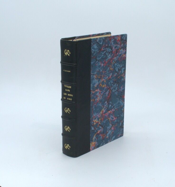
EDMOND , Charles
Voyage dans les mers du nord à bord de la corvette la Reine-Hortense
Paris, Michel Lévy Frères, 1863 , grand in-8 , 536 pp. ,reliure demi chagrin noir , dos à nerfs avec titre, couverture conservée avec son dos ,deuxième édition , illustré de 12 gravures hors-texte , non coupé , bel exemplaire
书商的参考编号 : PHO-1404
|
|
|
Eduard Rothert
Atlas zur Geschichte des Altertums
Archiv-Verlag:Braunschweig.2001. 26 Seiten.28 cm x 31 cm. Original-Pappband mit goldgeprägtem Deckel- und Rückentitel, ohne SU
书商的参考编号 : K42499

|
|
|
EDWARD ATLAS HAROLD A SMITH Additional Contributors
Hoskins Coal and Dock Corporation Petitioner v. Truax Traer Coal Company and United Electric Coal Companies. U.S. Supreme Court Transcript of Record with Supporting Pleadings
Gale U.S. Supreme Court Records 2011-10-28. Paperback. Good. Gale, U.S. Supreme Court Records paperback
书商的参考编号 : SONG1270342592 ???????? : 1270342592 9781270342595
|
|
|
Edwards, Linda; Brocklehurst, Ruth
Mein allererster Bildatlas.
Bindlach, Gondolino, 2004. 29 cm. 48 S., zahlr. Ill., Kt. Pappband, Deckelillustr. guter Zustand.
书商的参考编号 : 17823BB
|
|
|
Edwin L. Atlas
Basketball Visionetics: Mental Preparation for Better Play
2014-01-24. New. Ships with Tracking Number! INTERNATIONAL WORLDWIDE Shipping available. May be re-issue. Buy with confidence excellent customer service! unknown
书商的参考编号 : 1452587051n ???????? : 1452587051 9781452587059

|
|
|
Edwin L. Atlas
Basketball Visionetics: Mental Preparation for Better Play
2014-01-24. Good. Ships with Tracking Number! INTERNATIONAL WORLDWIDE Shipping available. May not contain Access Codes or Supplements. May be re-issue. May be ex-library. Shipping & Handling by region. Buy with confidence excellent customer service! unknown
书商的参考编号 : 1452587051 ???????? : 1452587051 9781452587059

|
|
|
EGGEDE Hans
Description et Histoire Naturelle du Groenland.
Copenhage Et Genève Chez Les Freres C. & A. Philiber 1763 Petit in-8 carré ( 180 X 125 mm ) de ( 2 ff.n.c. )-XXVIII-( 2 ff.n.c. de tables )-171 pages, plein veau fauve marbré, dos lisse orné de caissons et fleurons dorés, pièce de titre en maroquin olive, filet doré sur coupes, toutes tranches marbrées ( Reliure de lépoque ). EDITION ORIGINALE française bien complète de sa carte dépliante et de ses 10 gravures hors-texte. Feuillets roussis, la reliure est très fraîche, Rare.
书商的参考编号 : 382310

|
|
|
Eggers, Willy
Deutsches Land, deutsches Volk und die Welt : ein Kartenwerk. Unter Mithilfe zahlreicher Dienststellen und Erzieher und unter Mitarbeit von Mathias Volkenborn / Harms einheitliches Unterrichtswerk; Historische Atlas-Bibliothek. Nachdruck der Originalausgabe von 1937.
Wolfenbüttel : Melchior-Verlag. 76 S. 32,5*24,5 cm OPappband.
书商的参考编号 : 130585

|
|
|
EGRET FRANCOIS EDITIONS ATLAS ATLAS
LE FOSSE SUIVI DE FLORA DES EMBRUNS
EDITIONS ATLAS 2012 in8. 2012. Cartonné.
书商的参考编号 : 100067107

|
|
|
EGRET FRANCOIS EDITIONS ATLAS ATLAS
LE FOSSE SUIVI DE FLORA DES EMBRUNS
EDITIONS ATLAS 2012 in8. 2012. Cartonné.
书商的参考编号 : 100068133

|
|
 ?????????
 ?????PDF???
 RSS feed


