|
Speed John Gilmer
The horse in America; a practical treatise on the various types common in the United States with something of their history and varying characteristics 1905 Leather Bound
2019. Leather Bound. New. Leather Binding on Spine and Corners with Golden Leaf Printing on round Spine. Reprinted in 2019 with the help of original edition published long back 1905. This book is printed in black & white sewing binding for longer life Printed on high quality Paper re-sized as per Current standards professionally processed without changing its contents. As these are old books we processed each page manually and make them readable but in some cases some pages which are blur or missing or black spots. If it is multi volume set then it is only single volume if you wish to order a specific or all the volumes you may contact us. We expect that you will understand our compulsion in these books. We found this book important for the readers who want to know more about our old treasure so we brought it back to the shelves. Hope you will like it and give your comments and suggestions. Lang: - eng Pages 362. EXTRA 10 DAYS APART FROM THE NORMAL SHIPPING PERIOD WILL BE REQUIRED FOR LEATHER BOUND BOOKS. FOLIO EDITION IS ALSO AVAILABLE. hardcover
Bookseller reference : LB1111005580729
|
|
|
Speed John Gilmer
The horse in America; a practical treatise on the various types common in the United States with something of their history and varying characteristics 1905 Leather Bound
2019. Leather Bound. New. Leather Binding on Spine and Corners with Golden Leaf Printing on round Spine. Reprinted in 2019 with the help of original edition published long back 1905. This book is printed in black & white sewing binding for longer life Printed on high quality Paper re-sized as per Current standards professionally processed without changing its contents. As these are old books we processed each page manually and make them readable but in some cases some pages which are blur or missing or black spots. If it is multi volume set then it is only single volume if you wish to order a specific or all the volumes you may contact us. We expect that you will understand our compulsion in these books. We found this book important for the readers who want to know more about our old treasure so we brought it back to the shelves. Hope you will like it and give your comments and suggestions. Lang: - eng Pages 366. EXTRA 10 DAYS APART FROM THE NORMAL SHIPPING PERIOD WILL BE REQUIRED FOR LEATHER BOUND BOOKS. FOLIO EDITION IS ALSO AVAILABLE. hardcover
Bookseller reference : LB1111006229928
|
|
|
Speed John Gilmer
The horse in America : a practical treatise on the various types common in the United States with something of their history and varying characteristics 1905 Leather Bound
2019. Leather Bound. New. Leather Binding on Spine and Corners with Golden Leaf Printing on round Spine. Reprinted in 2019 with the help of original edition published long back 1905. This book is printed in black & white sewing binding for longer life Printed on high quality Paper re-sized as per Current standards professionally processed without changing its contents. As these are old books we processed each page manually and make them readable but in some cases some pages which are blur or missing or black spots. If it is multi volume set then it is only single volume if you wish to order a specific or all the volumes you may contact us. We expect that you will understand our compulsion in these books. We found this book important for the readers who want to know more about our old treasure so we brought it back to the shelves. Hope you will like it and give your comments and suggestions. Lang: - eng Pages 362. EXTRA 10 DAYS APART FROM THE NORMAL SHIPPING PERIOD WILL BE REQUIRED FOR LEATHER BOUND BOOKS. FOLIO EDITION IS ALSO AVAILABLE. hardcover
Bookseller reference : LB1111005580961
|
|
|
Speed John Gilmer
The horse in America; a practical treatise on the various types common in the United States with something of their history and varying characteristics 1905 Hardcover
2020. Hardcover. New. Lang: - eng Pages 366. Reprinted in 2020 with the help of original edition published long back 1905. This book is Printed in black & white Hardcover sewing binding for longer life with Matt laminated multi-Colour Dust Cover Printed on high quality Paper re-sized as per Current standards professionally processed without changing its contents. As these are old books we processed each page manually and make them readable but in some cases some pages which are blur or missing or black spots. If it is multi volume set then it is only single volume if you wish to order a specific or all the volumes you may contact us. We expect that you will understand our compulsion in these books. We found this book important for the readers who want to know more about our old treasure so we brought it back to the shelves. Any type of Customisation is possible with extra charges. Hope you will like it and give your comments and suggestions. hardcover
Bookseller reference : 1111006229928
|
|
|
Speed John Gilmer
The horse in America : a practical treatise on the various types common in the United States with something of their history and varying characteristics 1905 Hardcover
2020. Hardcover. New. Lang: - eng Pages 362. Reprinted in 2020 with the help of original edition published long back 1905. This book is Printed in black & white Hardcover sewing binding for longer life with Matt laminated multi-Colour Dust Cover Printed on high quality Paper re-sized as per Current standards professionally processed without changing its contents. As these are old books we processed each page manually and make them readable but in some cases some pages which are blur or missing or black spots. If it is multi volume set then it is only single volume if you wish to order a specific or all the volumes you may contact us. We expect that you will understand our compulsion in these books. We found this book important for the readers who want to know more about our old treasure so we brought it back to the shelves. Any type of Customisation is possible with extra charges. Hope you will like it and give your comments and suggestions. hardcover
Bookseller reference : 1111005580961
|
|
|
Speed John Gilmer
The horse in America; a practical treatise on the various types common in the United States with something of their history and varying characteristics 1905 Hardcover
2020. Hardcover. New. Lang: - eng Pages 356. Reprinted in 2020 with the help of original edition published long back 1905. This book is Printed in black & white Hardcover sewing binding for longer life with Matt laminated multi-Colour Dust Cover Printed on high quality Paper re-sized as per Current standards professionally processed without changing its contents. As these are old books we processed each page manually and make them readable but in some cases some pages which are blur or missing or black spots. If it is multi volume set then it is only single volume if you wish to order a specific or all the volumes you may contact us. We expect that you will understand our compulsion in these books. We found this book important for the readers who want to know more about our old treasure so we brought it back to the shelves. Any type of Customisation is possible with extra charges. Hope you will like it and give your comments and suggestions. hardcover
Bookseller reference : 1111005578448
|
|
|
Speed John Gilmer
The horse in America; a practical treatise on the various types common in the United States with something of their history and varying characteristics 1905
2020. Paperback. New. Lang: - eng Pages 366. Reprinted in 2020 with the help of original edition published long back 1905. This book is Printed in black & white sewing binding for longer life with Matt laminated multi-Colour Soft Cover HARDCOVER EDITION IS ALSO AVAILABLE Printed on high quality Paper re-sized as per Current standards professionally processed without changing its contents. As these are old books we processed each page manually and make them readable but in some cases some pages which are blur or missing or black spots. If it is multi volume set then it is only single volume if you wish to order a specific or all the volumes you may contact us. We expect that you will understand our compulsion in these books. We found this book important for the readers who want to know more about our old treasure so we brought it back to the shelves. Any type of Customisation is possible with extra charges. Hope you will like it and give your comments and suggestions. paperback
Bookseller reference : PB1111006229928
|
|
|
Speed John Gilmer
The horse in America : a practical treatise on the various types common in the United States with something of their history and varying characteristics 1905
2020. Paperback. New. Lang: - eng Pages 362. Reprinted in 2020 with the help of original edition published long back 1905. This book is Printed in black & white sewing binding for longer life with Matt laminated multi-Colour Soft Cover HARDCOVER EDITION IS ALSO AVAILABLE Printed on high quality Paper re-sized as per Current standards professionally processed without changing its contents. As these are old books we processed each page manually and make them readable but in some cases some pages which are blur or missing or black spots. If it is multi volume set then it is only single volume if you wish to order a specific or all the volumes you may contact us. We expect that you will understand our compulsion in these books. We found this book important for the readers who want to know more about our old treasure so we brought it back to the shelves. Any type of Customisation is possible with extra charges. Hope you will like it and give your comments and suggestions. paperback
Bookseller reference : PB1111005580961
|
|
|
Speed John Gilmer
The horse in America; a practical treatise on the various types common in the United States with something of their history and varying characteristics 1905
2020. Paperback. New. Lang: - eng Pages 356. Reprinted in 2020 with the help of original edition published long back 1905. This book is Printed in black & white sewing binding for longer life with Matt laminated multi-Colour Soft Cover HARDCOVER EDITION IS ALSO AVAILABLE Printed on high quality Paper re-sized as per Current standards professionally processed without changing its contents. As these are old books we processed each page manually and make them readable but in some cases some pages which are blur or missing or black spots. If it is multi volume set then it is only single volume if you wish to order a specific or all the volumes you may contact us. We expect that you will understand our compulsion in these books. We found this book important for the readers who want to know more about our old treasure so we brought it back to the shelves. Any type of Customisation is possible with extra charges. Hope you will like it and give your comments and suggestions. paperback
Bookseller reference : PB1111005578448
|
|
|
Speed John Gilmer
The horse in America; a practical treatise on the various types common in the United States with something of their history and varying characteristics 1905
2020. Paperback. New. Lang: - eng Pages 362. Reprinted in 2020 with the help of original edition published long back 1905. This book is Printed in black & white sewing binding for longer life with Matt laminated multi-Colour Soft Cover HARDCOVER EDITION IS ALSO AVAILABLE Printed on high quality Paper re-sized as per Current standards professionally processed without changing its contents. As these are old books we processed each page manually and make them readable but in some cases some pages which are blur or missing or black spots. If it is multi volume set then it is only single volume if you wish to order a specific or all the volumes you may contact us. We expect that you will understand our compulsion in these books. We found this book important for the readers who want to know more about our old treasure so we brought it back to the shelves. Any type of Customisation is possible with extra charges. Hope you will like it and give your comments and suggestions. paperback
Bookseller reference : PB1111005580729
|
|
|
Speed John Gilmer
The horse in America; a practical treatise on the various types common in the United States with something of their history and varying characteristics 1905 Hardcover
2020. Hardcover. New. Lang: - eng Pages 362. Reprinted in 2020 with the help of original edition published long back 1905. This book is Printed in black & white Hardcover sewing binding for longer life with Matt laminated multi-Colour Dust Cover Printed on high quality Paper re-sized as per Current standards professionally processed without changing its contents. As these are old books we processed each page manually and make them readable but in some cases some pages which are blur or missing or black spots. If it is multi volume set then it is only single volume if you wish to order a specific or all the volumes you may contact us. We expect that you will understand our compulsion in these books. We found this book important for the readers who want to know more about our old treasure so we brought it back to the shelves. Any type of Customisation is possible with extra charges. Hope you will like it and give your comments and suggestions. hardcover
Bookseller reference : 1111005580729
|
|
|
Speed John Gilmer
The Horse In America inscribed By Publisher
Lexington: Russell Lutes. Very Good. 1982. Softcover. Inscribed by publisher . Russell Lutes paperback
Bookseller reference : 267648
|
|
|
Speed John Gilmer
The Horse in America; a Practical Treatise on the Various Types Common in the United States with Something of Their History and Varying Characteristics With the Rare Dust jacket
New York: McClure Phillips & Co. 1905. First Edition . Hardcover. Near Fine/About Very Good. 8vo. pp. xii 287. Illustrated in black and white color frontispiece. Dust jacket protected in mylar. The dust jacket has minor chips at the top of the spine and corners 1 1/2" closed tear light stain on the front cover and light soiling on the spine but is basically all present after over 100 years. The book has very slight fading of the red cloth binding at one corner and a couple small numbers in ink on the front free end paper otherwise this book would be in fine condition. An unopened copy leaves not cut open. <br/> <br/> McClure, Phillips & Co. hardcover
Bookseller reference : 000182
|
|
|
Speed John Gilmer
The Horse in America; A Practical Treatise on the Various Types Common in the United States With Something of Their History and Varying Characteristics
McClure Phillips & Co 1905-01-01. Hardcover. Good. Library rebound in red buckram cloth with white spine titles; very little wear to exterior; 8vo; no jacket. Ex library with typical stamps and markings; frontispiece in color with tissue guard additional illustrations in black and white; no internal markings; 287 pages. McClure, Phillips & Co hardcover
Bookseller reference : 235558
|
|
|
Speed John Gilmer
The Horse in America: A Practical Treatise
Russell Lutes 1982. Soft cover. Very Good. 287 pp. Very good condition softcover reprint of classic. Light edgewear interior clean and bright. 8vo 8" - 9" tall Professional bookseller for twenty years. Orders shipped daily in cardboard bookfolds. Russell Lutes paperback
Bookseller reference : 3182
|
|
|
SPEED John
The Invasions of England and Ireland
London: Performed by John Speed and are to be solde in Popes head alley by George Humble 1627. with all their civill wars since the conquest. 1627. A map of the United Kingdom noting every time the country has been invaded before the year of the map’s production. John Speed 1552-1629 was the outstanding cartographer of his age. His ‘Theatre of Great Britain’ was the first atlas of the British Isles: Speed prepared the maps himself about two years before they were published. His maps and books dominated the seventeenth-century English market. The present map is taken from the 1627 English edition published by George Humble. Chubb XXV. Performed by John Speed and are to be solde in Popes head alley by George Humble, unknown
Bookseller reference : 11913

|
|
|
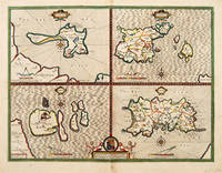
SPEED John.
The Islands.
London. c1646. Size: 430 x 550 mm. Copperplate engraving. Hand coloured. Good condition. Some minor staining to the centrefold and surrounding area. An excellent map by John Speed of the English Islands of: Farne and Holy Island off the Northumbrian coast; and the Channel Islands of Jersey and Guernsey. Each quatered map has a compass rose dividers and a mileage scale. London. unknown
Bookseller reference : 63961
|
|
|
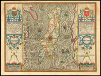
SPEED John
The Isle of Man
London 1627. exactly described and into several parishes divided with every town village baye creke and river therein conteyned. 1627. Engraved map with hand colouring. A beautifully coloured map of the Isle of Man. John Speed 1552-1629 was the outstanding cartographer of his age. His ‘Theatre of Great Britain’ was the first atlas of the British Isles: Speed prepared the maps himself about two years before they were published. His maps and books dominated the seventeenth-century English market. The present map is taken from the 1627 English edition published by George Humble. Chubb XXV. unknown
Bookseller reference : 11783

|
|
|
SPEED John
The Isle of Man
London: to be sold by Roger Rea the Elder and younger at ye Golden Crosse in Cornhill against ye Exchange 1665. Exactly described and into several parishes divided with every Towne Village Baye Creke and River therein conteyned. The bordring Coasts wherewith it is circulated in their situations sett and by the Compase accordigly shewed with their true distance from every place unto this Island by a severall scale observed. Described by Tho Durham Ano. 1595. 1665. Double-page engraved map fine contemporary outline hand colour upper left and right margins skilfully repaired margins reinforced with japan paper. The map bears the imprint of Roger Rea the Elder and Younger. The Reas had purchased the rights to Speed's work form William Garrett in 1589 who had previously purchased them from the widow of William Humble in the same year. Skelton suggests that the father and son intended a new edition of the atlas for the Restoration of 1660. However the atlas would appear not to have been published until 1665. This is borne out by an advertisement in the Term Catalogue by the subsequent owners of the plates Thomas Bassett and Richard Chiswell in 1675:"Mr John Speed's. Geography of the Kingdoms of England Scotland and Ireland. together with his Prospect. all in one entire Volume hath been for seven Years past out of Print the greatest part of an Impression then newly Printed being destroyed by the late dreadful Fire 1666". This is borne out by the rarity of the Rea edition of the atlas. There is evidence that they planned an edition of 1666 as there are impressions of Sussex Buckingham and Derby with Rea's imprint which bear that date. Rea would later sell the plates to Bassett and Chiswell who would publish a new edition in 1676. to be sold by Roger Rea the Elder and younger at ye Golden Crosse in Cornhill against ye Exchange, unknown
Bookseller reference : 1791
|
|
|
Speed John:
The Kingdome of Irland devided into severall Provinces and then again devided into Counties. Newly Described.
London John Sudbury and George Humble 1616. Copper engraving 38.5 x 50.5 cm modern hand colour one or two trivial marginal nicks and tears and a couple of light spots and stains English text on verso. The costumed figures illustrate Speed�s perception of the different degrees of Irish society: �gentle� �civill� and �wilde�. John Speed 1552-1629 Speed had no official status as a cartographer and only limited access to the best available offical maps many of which were in mansucript form. For his general map he does seems to have access to some of Robert Lythe�s surveys of central and southern Ireland made in the 1570s and he also drew heavily on the printed maps by Gerard Mercator of 1595 and Baptista Boazio�s of 1599. It was the most advanced published map of Ireland of its day only fully superseded by William Petty�s in the 1680s. Speed is unquestionably the most significant British map-maker of the seventeenth-century. A brief note from Granger's Bibliographical History of England 1779 contains most of the information we have about Speed's life: "John Speed who was bred a Tailor was by the generosity of Sir Fulk Grevil his patron set free from a manual employment and enabled to pursue his studies to which he was strongly inclined by the bent of his genius. The fruits of them were his Theatre of Great Britain containing an entire set of maps of the counties drawn by himself his History of Great Britain richly adorned with seals coins & medals from the Cotton collection; and his Genealogies of Scripture first bound up with the Bible in 1611 which was the first edition of the present English translation. His maps were very justly esteemed & his History of Great Britain was in its kind incomparably more complete than all the histories of his predecessors put together ." The first edition of Speed's "Theatre" was published in 1612. It was the first full atlas of the British Isles and the first attempt made by an Englishman to match the achievements of the great continental publishing houses - although much of the engraving of the copper plates was performed in Amsterdam by Jodocus Hondius. Speed was an antiquary and intended that his atlas should be read in conjunction with his history of Britain. He managed to include a wealth of historical detail on his 'modern' county maps carefully selected to illustrate a pro-Stuart view of British identity and the inset town plans many surveyed by himself together comprise the first collection of town plans of the British Isles. All in all the �Theatre� is a highly decorative and politically charged volume as well as a useful one. It was a great success and there were editions printed throughout the 17th century. Map unknown
Bookseller reference : 9037
|
|
|
SPEED John
The Kingdome of England
London: and are to be solde by Roger Rea the Elder and younger at ye Golden Crosse in Cornhill against the Exchange 1665. Described by Christopher Saxton augmented by John Speed. 1665. Double-page engraved map fine contemporary outline hand colour upper left and right margin skilfully repaired top margin trimmed to neatline. The map bears the imprint of Roger Rea the Elder and Younger. The Reas had purchased the rights to Speed's work from William Garrett in 1589 who had previously purchased them from the widow of William Humble in the same year. Skelton suggests that the father and son intended a new edition of the atlas for the Restoration of 1660. However the atlas would appear not to have been published until 1665. This is borne out by an advertisement in the Term Catalogue by the subsequent owners of the plates Thomas Bassett and Richard Chiswell in 1675:"Mr John Speed's. Geography of the Kingdoms of England Scotland and Ireland. together with his Prospect. all in one entire Volume hath been for seven Years past out of Print the greatest part of an Impression then newly Printed being destroyed by the late dreadful Fire 1666". This is borne out by the rarity of the Rea edition of the atlas. There is evidence that they planned an edition of 1666 as there are impressions of Sussex Buckingham and Derby with Rea's imprint which bear that date. Rea would later sell the plates to Bassett and Chiswell who would publish a new edition in 1676. Skelton 81. and are to be solde ,by Roger Rea the Elder and younger at ye Golden Crosse in Cornhill against the Exchange unknown
Bookseller reference : 1717

|
|
|
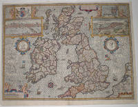
SPEED John
The Kingdome of Great Britaine and Ireland.
London: Are to be sold by Roger Rea the Elder and younger at the Golden Crosse in Cornhill against the Exchange 1665. 1665. Double-page engraved map fine contemporary outline hand colour upper left and right margins skilfully repaired. The map bears the imprint of Roger Rea the Elder and Younger. The Reas had purchased the rights to Speed's work from William Garrett in 1589 who had previously purchased them from the widow of William Humble in the same year. Skelton suggests that the father and son intended a new edition of the atlas for the Restoration of 1660. However the atlas would appear not to have been published until 1665. This is borne out by an advertisement in the Term Catalogue by the subsequent owners of the plates Thomas Bassett and Richard Chiswell in 1675:"Mr John Speed's. Geography of the Kingdoms of England Scotland and Ireland. together with his Prospect. all in one entire Volume hath been for seven Years past out of Print the greatest part of an Impression then newly Printed being destroyed by the late dreadful Fire 1666". This is borne out by the rarity of the Rea edition of the atlas. There is evidence that they planned an edition of 1666 as there are impressions of Sussex Buckingham and Derby with Rea's imprint which bear that date. Rea would later sell the plates to Bassett and Chiswell who would publish a new edition in 1676. Skelton 81. Are to be sold by Roger Rea the Elder and younger at the Golden Crosse in Cornhill against the Exchange unknown
Bookseller reference : 1716

|
|
|
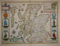
Speed John:
The Kingdome of Scotland
London: Basset & Chiswell 1676. Copper engraving 38.5 x 51.5 cms recent hand-colour light crease in the lower right hand corner but generally a very good example; English text on verso. Cartographically Speed follows Mercator but his is one of the most distinctive and decorative early maps of Scotland. The portraits in the borders originally represented James VI and I and his family including a young Prince Charles. The royal family was burnished from the copper plate during the Interregnum and replaced with the �commoners� seen here: a �Scotch� man and woman and a �Highland� man and woman notable as early depictions of tartan. John Speed 1552-1629 is unquestionably the most significant British map-maker of the seventeenth-century. A brief note from Granger's Bibliographical History of England 1779 contains most of the information we have about Speed's life: "John Speed who was bred a Tailor was by the generosity of Sir Fulk Grevil his patron set free from a manual employment and enabled to pursue his studies to which he was strongly inclined by the bent of his genius. The fruits of them were his Theatre of Great Britain containing an entire set of maps of the counties drawn by himself his History of Great Britain richly adorned with seals coins & medals from the Cotton collection; and his Genealogies of Scripture first bound up with the Bible in 1611 which was the first edition of the present English translation. His maps were very justly esteemed & his History of Great Britain was in its kind incomparably more complete than all the histories of his predecessors put together ." The first edition of Speed's "Theatre" was published in 1612. It was the first atlas of the British Isles and the first attempt made by an Englishman to match the achievements of the great continental publishing houses - although much of the engraving of the copper plates was performed in Amsterdam by Jodocus Hondius. Speed was an antiquary and intended that his atlas should be read in conjunction with his history of Britain. He managed to include a great deal of historical detail on his 'modern' county maps and the inset town plans some surveyed by himself together comprise the first collection of town plans of the British Isles all in all making the Theatre a highly decorative as well as a useful volume. It was a great success and there were editions printed throughout the seventeenth-century. Map Basset & Chiswell unknown
Bookseller reference : 7572
|
|
|
Speed John
THE KINGDOME OF GREAT BRITAINE AND IRELAND
London: c. 1614. second edition. Right margin trimmed close with thick tape also verso of margins otherwise a fine impression. 14-3/4 x 19-3/4-37.4 x 50.1 cm. Shirley British Isles 1477-1650#343; Skelton #10 A lovely early view of Great Britian Scotland and Ireland. Insets of London after an earlier view by Visscher upper left and Edinburgh and the Orkney islands upper right Two medallion portraits featuring Britannia and King Coel flank either side. The text has been reset from the earlier 1611 edition
Bookseller reference : 1264
|
|
|
Speed John Gilmer
The National Academy of Design Volume 1 1893 Leather Bound
2019. Leather Bound. New. Leather Binding on Spine and Corners with Golden Leaf Printing on round Spine. Reprinted in 2019 with the help of original edition published long back 1893. This book is printed in black & white sewing binding for longer life Printed on high quality Paper re-sized as per Current standards professionally processed without changing its contents. As these are old books we processed each page manually and make them readable but in some cases some pages which are blur or missing or black spots. We expect that you will understand our compulsion in these books. We found this book important for the readers who want to know more about our old treasure so we brought it back to the shelves. Hope you will like it and give your comments and suggestions. Lang: - eng Vol: - Volume 1 Pages 16. EXTRA 10 DAYS APART FROM THE NORMAL SHIPPING PERIOD WILL BE REQUIRED FOR LEATHER BOUND BOOKS. FOLIO EDITION IS ALSO AVAILABLE. Volume 1 hardcover
Bookseller reference : LB1111001660001
|
|
|
SPEED John
The North and East Ridins of Yorkshire
London: John Speed 1627. Map. Hand colored engraving. 16" x 21" This beautifully colored map of the North and East Ridings of Yorkshire has incredible detail. Cities towns mountains rivers and lakes are labeled clearly and colored accordingly. There are also illustrations of ships and ocean animals depicted in the water. There are insets of the cities of Hull and Richmond in opposite bottom left and top right corners respectively. On the right side and at the top Coats of Arms for numerous noble families are illustrated. Light staining lower right. John Speed 1552-1629 born in Cheshire and a tailor by profession until he was 50 is widely considered to be the most famous English cartographer of the 17th century. He is noted for placing England in the mainstream of map publishing an industry which was at the time dominated by the Dutch. John Speed unknown
Bookseller reference : 285022

|
|
|
Speed John:
The Province of Connaugh with the Citie of Galwaye described .
London John Sudbury and George Humble 1616. Copper engraving 38.5 x 51.5 cm inset view of Galway modern hand colour nicks and tears to lower margin with some loss not affecting engraved area closed centrefold split old paper repairs on verso a couple of small stains in the lower margin English text on verso. The plan of Galway is the earliest printed map of the city and Speed was also the first to include individual maps of the four Irish provinces in an atlas of the British Isles. His �Theatre� was carefully constructed to illustrate his �History� and to support a particular pro-Stuart view of British identity of which Ireland had become an integral part. Decorative coats of arms of distinguished local figures from the past historical notes and battle scenes on his English county maps contributed towards the same goal being carefully chosen to contrast the anarchy and upheavals of the past with the peace and prosperity of the Tudor and Stuart present. The omissions and silences on the Irish maps raise intriguing questions of their own. Speed seems to have little or no access to the best recent official maps such as those prepared by the unfortunate Richard Bartlett. As reported by the poet and politician John Davies 'when he came to Tyrconnell the inhabitants took off his head because they would not have their country discovered' a reminder that map-making can be a hazardous occupation. Speed had no official status and no right to access maps such as Bartlett's but he also made no efforts to update his Irish maps after 1610 for example to show the new plantation towns of Ulster or even to correct minor errors which is a good indication that few of Speed's early readers had first-hand knowledge of the province or used his maps to find their way around. Map unknown
Bookseller reference : 9034
|
|
|
SPEED John
The Province of Connaugh
London: Performet by John Speed and are to be sold in Popes Head Alley against the Exchange by John Sudbury and George Humble 1627. with the citie of Galwaye described. 1627. Engraved map with hand colouring. A map of Connaught with an inset map of Galway. John Speed 1552-1629 was the outstanding cartographer of his age. His ‘Theatre of Great Britain’ was the first atlas of the British Isles: Speed prepared the maps himself about two years before they were published. His maps and books dominated the seventeenth-century English market. The present map is taken from the 1627 English edition published by George Humble. Chubb XXV. Performet by John Speed and are to be sold in Popes Head Alley against the Exchange by John Sudbury and George Humble, unknown
Bookseller reference : 11811

|
|
|
SPEED John
The province of Mounster
London: Performed by Iohn Speed and are to be sould in Popes head Alley by I. Sudbury and Georg. Humble 1627. 1627. Engraved map with hand colouring. A map of Munster with inset maps of Cork and Limerick. John Speed 1552-1629 was the outstanding cartographer of his age. His ‘Theatre of Great Britain’ was the first atlas of the British Isles: Speed prepared the maps himself about two years before they were published. His maps and books dominated the seventeenth-century English market. The present map is taken from the 1627 English edition published by George Humble. Chubb XXV. Performed by Iohn Speed, and are to be sould in Popes head Alley by I. Sudbury and Georg. Humble, unknown
Bookseller reference : 11813

|
|
|
Speed John Gilmer
The Right of Privacy Volume 163 1896 Leather Bound
2019. Leather Bound. New. Leather Binding on Spine and Corners with Golden Leaf Printing on round Spine. Reprinted in 2019 with the help of original edition published long back 1896. This book is printed in black & white sewing binding for longer life Printed on high quality Paper re-sized as per Current standards professionally processed without changing its contents. As these are old books we processed each page manually and make them readable but in some cases some pages which are blur or missing or black spots. We expect that you will understand our compulsion in these books. We found this book important for the readers who want to know more about our old treasure so we brought it back to the shelves. Hope you will like it and give your comments and suggestions. Lang: - eng Vol: - Volume 163 Pages 12. EXTRA 10 DAYS APART FROM THE NORMAL SHIPPING PERIOD WILL BE REQUIRED FOR LEATHER BOUND BOOKS. FOLIO EDITION IS ALSO AVAILABLE. Volume 163 hardcover
Bookseller reference : LB1111001650186
|
|
|
Speed John
The Temple Dancer: A Novel of India Novels of India
St. Martin's Griffin 2007-07-24. Mass Market Paperback. Like New. St. Martin's Griffin paperback
Bookseller reference : 0312325495-1-18728438 ISBN : 0312325495 9780312325497

|
|
|
Speed John
The Temple Dancer: A Novel of India Novels of India
St. Martin's Griffin. Used - Very Good. Very Good condition. St. Martin's Griffin unknown
Bookseller reference : T08B-03188 ISBN : 0312325495 9780312325497
|
|
|
Speed John
The Temple Dancer: A Novel of India
St. Martin's Griffin. Used - Very Good. Former Library book. Great condition for a used book! Minimal wear. St. Martin's Griffin unknown
Bookseller reference : GRP114564376 ISBN : 0312325495 9780312325497
|
|
|
Speed John
The Temple Dancer: A Novel of India
St. Martin's Press. Used - Very Good. Ships from the UK. Great condition for a used book! Minimal wear. 100% Money Back Guarantee. Your purchase also supports literacy charities. St. Martin's Press unknown
Bookseller reference : GRP114554516 ISBN : 0312325487 9780312325480

|
|
|
Speed John
The Temple Dancer: A Novel of India Novels of India
St. Martin's Griffin. Used - Good. Good condition. St. Martin's Griffin unknown
Bookseller reference : S06B-02272 ISBN : 0312325495 9780312325497
|
|
|
Speed John
The Temple Dancer: A Novel of India
St. Martin's Press. Used - Very Good. Great condition for a used book! Minimal wear. St. Martin's Press unknown
Bookseller reference : GRP98623664
|
|
|
Speed John
The Temple Dancer: A Novel of India
U.S.A.: St. Martin's Press 2006. First Edition . Hardcover. As New/As New. 1st Edit 1st print very lightly used hardcover with dust jacket in excellent condition no marks or writing binding tight dust jacket not price-clipped is bright and glossy. <br/> <br/> St. Martin's Press hardcover
Bookseller reference : 902454 ISBN : 0312325487 9780312325480
|
|
|
Speed John
The Temple Dancer: A Novel of India
St. Martin's Press. Used - Good. Ships from Reno NV. Shows some signs of wear and may have some markings on the inside. 100% Money Back Guarantee. Shipped to over one million happy customers. Your purchase benefits world literacy! St. Martin's Press unknown
Bookseller reference : GRP88440886
|
|
|
Speed John
The Temple Dancer: A Novel of India
St. Martin's Griffin. Used - Good. Shows some signs of wear and may have some markings on the inside. St. Martin's Griffin unknown
Bookseller reference : GRP10691520 ISBN : 0312325495 9780312325497
|
|
|
Speed John
The Temple Dancer: A Novel of India
St. Martin's Press. Used - Very Good. Great condition for a used book! Minimal wear. St. Martin's Press unknown
Bookseller reference : GRP29678575 ISBN : 0312325487 9780312325480
|
|
|
SPEED JOHN
The Theatre of the Empire of Great Britaine: presenting an exact geography of the Kingdomes of England Scotland Ireland and the Iles adioyning. WITH A Prospect of the most famous parts of the World
London: John Sudbury & George Humble; John Dawson for George Humble 1611. 1st Edition. Hardcover. Very Good. THE EARLIEST ATLAS OF THE BRITISH ISLES AD THE EARLIEST WORLD ATLAS BY AN ENGLISHMAN. FIRST EDITION of "The Theatre"; 1611 bound with the second edition 1631 of the "Prospect" "The Theatre of the Empire of Great Britaine. was the earliest English attempt at producing an atlas on a grand scale with the first detailed maps of the provinces of Ireland the first set of county maps consistently attempting to show the boundaries of territorial divisions and the first truly comprehensive set of English town plans-a notable contribution to British topography. Perhaps as many as fifty of the seventy-three towns had not previously been mapped and about fifty-one of the plans were probably Speed's own work. A balance is struck between the modern and historical with information placed on the edges of the maps about antiquarian remains and sites and vignettes of famous battles together with arms of princes and nobles. This additional information is one of the Theatre's most significant contributions" Dictionary of National Biography. The "Theatre" is complete with engraved architectural title engraved Royal Achievements by Jodocus Hondius dated 1611 letterpress list of kingdoms and woodcut royal arms three letterpress section titles with woodcut borders three woodcut royal arms 67 double-page engraved maps most by Jodocus Hondius woodcut head- and tail-pieces and initials mounted on guards throughout. The "Prospect" was intended as a supplement to the "Theatre" and includes 22 maps of different parts of the world including the famous world map presumably by Abraham Goos and the map of America both showing California as an island. With engraved portrait frontispiece bound before "Theatre". NOTE: The "Prospect" is lacking "Invasions" but with 'Canaan' bound in its place and lacking the final text leaf on 'Civill Warres'. Also with portrait trimmed to platemark and laid down. Provenance: J.B. Speed Art Museum Louisville Kentucky bookplate. London: John Sudbury & George Humble; John Dawson for George Humble 1611; 1631. Folio 414x287mm 19th-century full calf with elaborately gilt-decorated spine. Joints repaired small chip to label. Some offsetting including on the world map some marginal repaired closed tears some maps closely cropped. Most maps including the world map with good strong impressions. John Sudbury & George Humble; John Dawson for George Humble hardcover
Bookseller reference : 956

|
|
|
SPEED John 1552 1629.
The Theatre of the Empire of Great Britaine. as also A Prospect of the most famous Parts of the World
London: Thomas Bassett and Richard Chiswell 1676. 5 parts making 2 volumes in one. Folio 17 x 12 2/8 inches. Letterpress general title-page printed in red and black 4 sectional title-pages. Engraved additional title-page and arms of Charles II the "Theatre" with 68 double-page engraved maps of the Counties of England Wales Scotland and Ireland most by Jodocus Hondius after Christopher Saxton; the "Prospect" with 28 double-page engraved maps of various parts of the world some light mostly marginal browning throughout. FINE modern black morocco gilt to an 17th-century style by Trevor Lloyd. Provenance: With the near contemporary signature of Don Murray at the head of the title-page "The 1676 edition of John Speed's famous atlas marked the high point of its publishing history" Burden. "'The Theatre of the Empire of Great Britaine' followed the model of Ortelius's 'Theatrum orbis terrarum'-first published in English in 1606-in its title and its format with map sheets backed by historical and geographical texts and gazetteers of place names. This was the earliest English attempt at producing an atlas on a grand scale with the first detailed maps of the provinces of Ireland the first set of county maps consistently attempting to show the boundaries of territorial divisions and the first truly comprehensive set of English town plans-a notable contribution to British topography. Perhaps as many as fifty of the seventy-three towns had not previously been mapped and about fifty-one of the plans were probably Speed's own work. In 1606 Speed might have been helped by his son John in surveying towns. A balance is struck between the modern and historical with information placed on the edges of the maps about antiquarian remains and sites and vignettes of famous battles together with arms of princes and nobles. This additional information is one of the 'Theatre''s most significant contributions. Scotland is covered in less detail as Timothy Pont was surveying there. Individual maps for the Theatre were prepared from about 1602 plates were engraved by Jodocus Hondius-noted for his skills in decoration-from 1607 George Humble was granted a privilege to print the 'Theatre' for twenty-one years from 1608 and the 'Theatre' and 'History' were published together in 1611-12. They were an immediate success: three new editions and issues of each appeared during Speed's lifetime and a miniature version was first published about 1619-20. The maps in the 'Theatre' became the basis for subsequent folio atlases until the mid-eighteenth century. By 1625 Speed had lost his sight. Nevertheless in 1627 he published A Prospect of the most Famous Parts of the World which shared a title-page with the 1627 edition of the Theatre. 'THE PROSEPCT' THE EARLIEST WORLD ATLAS BY AN ENGLISHMAN though not the first to be published in England" Sarah Bendall for DNB. 'The Prospect' includes the World map showing California as an Island Continents and 6 maps of America 4 of which appear for the first time including: "A Map of New England and New York" Burden 455; "A Map of Virginia and Maryland" Burden 456 "A new Description of Carolina" Burden 457. Chubb XXVII; Wing S4886; Skel Catalogued by Kate Hunter. London: Thomas Bassett and Richard Chiswell, 1676. unknown
Bookseller reference : 72lib618
|
|
|
SPEED John
The West Riding of Yorkeshyre
London: Performed by Iohan Speede And are to be sold in Popes heade Alley against the Exchange by Iohn Sudbury and George Humbell at the white horse 1627. with the most famous and fayre citie Yorke described. 1627. Engraved map with hand colouring. A beautifully coloured map of the West Riding of Yorkshire with an inset map of the city of York. John Speed 1552-1629 was the outstanding cartographer of his age. His ‘Theatre of Great Britain’ was the first atlas of the British Isles: Speed prepared the maps himself about two years before they were published. His maps and books dominated the seventeenth-century English market. The present map is taken from the 1627 English edition published by George Humble. Chubb XXV. Performed by Iohan Speede, And are to be sold in Popes heade Alley, against the Exchange, by Iohn Sudbury and George Humbell at unknown
Bookseller reference : 11779

|
|
|
Speed John:
The West Ridinge of Yorkeshire with the most famous and fayre citie Yorke described
London Roger Rea the elder and younger c. 1665. Copper engraving 38.5 x 51 cm inset plan of York modern hand-colour small areas of marginal discoloration where previously tabbed into a mount English text on verso. The map bears the relatively scarce imprint of Roger Rea the Elder and Younger. The rights to Speed's work remained within the Humble family until 1659 when they were purchased by William Garret. Within months he had sold them to the Reas who appear to have planned a new edition to commemorate the Restoration of Charles II in 1660. In the event publication seems to have been delayed until at least 1665 and three county maps bear the newly engraved date 1666 which suggests that it had been pushed back still further. Rea sold the copper printing plates to Richard Bassett and Thomas Chiswell who claimed in the preface to their edition of 1676 which does survive in reasonable numbers that the bulk of the Reas' edition had been destroyed in the Great Fire. John Speed 1552-1629 is unquestionably the most significant English map-maker of the seventeenth-century. A brief note from Granger's Bibliographical History of England 1779 contains most of the information we have about Speed's life: "John Speed who was bred a Tailor was by the generosity of Sir Fulk Grevil his patron set free from a manual employment and enabled to pursue his studies to which he was strongly inclined by the bent of his genius. The fruits of them were his Theatre of Great Britain containing an entire set of maps of the counties drawn by himself his History of Great Britain richly adorned with seals coins & medals from the Cotton collection; and his Genealogies of Scripture first bound up with the Bible in 1611 which was the first edition of the present English translation. His maps were very justly esteemed & his History of Great Britain was in its kind incomparably more complete than all the histories of his predecessors put together ." The first edition of Speed's "Theatre" was published in 1612. It was the first atlas of the British Isles and the first attempt made by an Englishman to match the achievements of the great continental publishing houses - although much of the engraving of the copper plates was performed in Amsterdam by Jodocus Hondius. Speed was an antiquary and intended that his atlas should be read in conjunction with his history of Britain. He managed to include a great deal of historical detail on his 'modern' county maps and the inset town plans some surveyed by himself together comprise the first collection of town plans of the British Isles all in all making the Theatre a highly decorative as well as a useful volume. It was a great success and there were editions printed throughout the seventeenth-century. Map unknown
Bookseller reference : 8925
|
|
|
SPEED John 1552 1629
Theatre of the Empire of Great Britaine. Surrey Described and Divided into Hundreds.
London: Bassett & Chiswell 1676. Single sheet 15 x 20 inches Full margins showing the plate mark slight browning to edge light watermark top centerfold. An excellent county map of Surrey; as part of Speed's world acclaimed Theatre of the Empire of Great Britaine. Engraved by Jodocus Hondius in his workshop in Amsterdam this map is a prime example of the level of craft and detail found in the Theatre of the Empire of Great Britaine. "Jodocus Honius caelavit Anno Domini 1666". An elegant title cartouche presents Surrey. The county of Surrey is a wealthy populous 'home county' situated near London. It is well known for having many noted nature spots and woodlands; as marked shown elegantly in this map. It is particularly interesting to see Speed chose two royal palaces to engrave rather than the more customary county town plan. The first engraving is Nonsuch palace. This palace was built by King Henry VIII in 1538 just after his son Edward was born. It is thought that Nonsuch palace got its name from the expression 'that no such palace could ever be its equal'. The other engraving is of Richmond Palace. This palace was built by Henry VIII's father King Henry VII. The palace took its name from one of his many titles in this case; the Earl of Richmond. Speed adorns his map with the arms of the county nobility from the Norman Conquest to the then present time. The last entry has been curiously left blank. Speed drew on the work of John Norden for this map of Essex: "Described by the travills of John Norden. Augmented and performed by Iohn Speede". "Are to be solde by Tho. Bassett in Fleetstret and Richard Chiswell in St Pauls Churchyard." The county maps found in the Theatre of the Empire of Great Britaine were the first consistent attempt to show territorial divisions but it was mainly Speed's town plans that were the major innovation and probably his greatest contribution to British cartography. Together they formed the first printed collection of town plans of the British Isles and for at least 50 of the 73 included in the Theatre it was the first time these towns had been mapped. While being the first English atlas of the British Isles Speed's Atlas was also one of the first attempts to accurately survey Ireland and to incorporate a comprehensive list of their town plans into the maps. The 1676 edition of Speed's atlas never came with original color. The examples of this map of Surrey should always be uncolored and never colored. Born in Cheshire John Speed developed his interest in maps in the 1580s after moving to London to pursue his passions outside of tailoring. He there joined the Society of Antiquaries where his enthusiasm for cartography won him the attention of William Camden Robert Cotton and Sir Fulke Greville. By working with these figures Speed was able to do a large amount of research for his own work. In 1596 Greville bequeathed Speed with an unlimited allowance to research and then later write the Historie of Great Britaine. It was during this project which Speed had the encouragement to add a cartographic supplement to the work - what we today know as his most famous atlas. After being first published in 1611-1612 the 'Theatre of Great Britain' dominated the seventeenth-century English map market going through many reprints and editions. Thanks to the Atlas' success Speed earned the title of England's most well-known Stuart period cartographer and his work became the blueprint for folio atlases until the mid-18th century. Historically Speed is also noted for placing England into the mainstream of map publishing which had been dominated by the Dutch since the late sixteenth century. This map of Surrey is an excellent part of the Theatre of the Empire of Great Britaine and would be an outstanding addition to all map collections. For more information on this map or a warm welcome to see other maps and books of our collection at 72nd Street NYC please contact Natalie Zadrozna. . London: Bassett & Chiswell unknown
Bookseller reference : 72NZ10
|
|
|
SPEED John 1552 1629
Theatre of the Empire of Great Britaine. The North and East Ridins of Yorkshire.
London:Bassett & Chiswell 1676. Single sheet 15 x 20 inches Full margins showing the plate mark slight edge browning light rubbing spot left. An elegantly uncolored map of the North and East Riding of Yorkshire; a highly sought after element of John Speed's Theatre of the Empire of Great Britaine. It was elaborated engraved by Jodocus Hondius in his workshop in Amsterdam in 1610. Hondius left no part of this map uncovered; filling it with waters and sea monsters; land and trees; and detailing. A title cartouche introduces us to this map accompanied by the coat of arms of Charles I. The North and East are divided by a thicker border; providing the viewer with markings of towns parks and significant buildings. The inset plans depict the towns of Richmond and another of Hull. The latter is shown with its coat of arms; a guided listing of areas observed corresponding to the numbered streets. The outskirts of Hull are a pastoral background with men working the fields and windmills grinding grain. The town plan of Richmond shows a larger metropolis. The Richmond Castle and its town square claiming most of the space. Speed adds a small curious addition of a tunnel running under a river into the castle. A framed collection of coat of arms from the ruling Earls and Dukes over the ages covers the upper North portion of the map. The bottom section depicts an elegant Scale of Miles adorned with winged cherubim and a pair of dividers. The county maps found in the Theatre of the Empire of Great Britaine were the first consistent attempt to show territorial divisions but it was mainly Speed's town plans that were the major innovation and probably his greatest contribution to British cartography. Together they formed the first printed collection of town plans of the British Isles and for at least 50 of the 73 included in the Theatre it was the first time these towns had been mapped. While being the first English atlas of the British Isles Speed's Atlas was also one of the first attempts to accurately survey Ireland and to incorporate a comprehensive list of their town plans into the maps. The 1676 edition of Speed's atlas never came with original color. The uncolored editions of Speed's maps are classic and highly sought after; as they reflect the true quality of Speed's work unhindered by colorists. The examples of this map of the North and East Ridings of Yorkshire should always be left uncolored. Born in Cheshire John Speed developed his interest in maps in the 1580s after moving to London to pursue his passions outside of tailoring. He there joined the Society of Antiquaries where his enthusiasm for cartography won him the attention of William Camden Robert Cotton and Sir Fulke Greville. By working with these figures Speed was able to do a large amount of research for his own work. In 1596 Greville bequeathed Speed with an unlimited allowance to research and then later write the Historie of Great Britaine. It was during this project which Speed had the encouragement to add a cartographic supplement to the work - what we today know as his most famous atlas. After being first published in 1611-1612 the 'Theatre of Great Britain' dominated the seventeenth-century English map market going through many reprints and editions. Thanks to the Atlas' success Speed earned the title of England's most well-known Stuart period cartographer and his work became the blueprint for folio atlases until the mid-18th century. Historically Speed is also noted for placing England into the mainstream of map publishing which had been dominated by the Dutch since the late sixteenth century. This map of the North and East Ridings of Yorkshire is an excellent part of the Theatre of the Empire of Great Britaine and would make an outstanding addition to all map collections. For more information on this map or a warm welcome to see other maps and books of our collection at 72nd Street NYC please contact Natalie Zadrozna. . London:Bassett & Chiswell unknown
Bookseller reference : 72NZ13
|
|
|
SPEED John 1552 1629.
Theatre of the Empire of Great Britaine. �Breknoke Both Shyre and Town described. Anno Domini 1610�.
London: Bassett & Chiswell 1676. Single sheet 15 x 20 inches Full margins showing the plate mark slight browning to edge light foxing offsetting small spot left A handsome uncolored 1676 edition map of Breknokeshire Brecknockshire; as part of the renowned Theatre of the Empire of Great Britaine by English cartographer John Speed. The plates for Speed�s maps were engraved by Jodocus Honius a great Dutch mapmaker in 1610. These maps are highly sought after for their beautiful accuracy detailing and embellishments. This map of Breknokeshire is one of the finest available of the county exhibiting the true variety of the region with mountains hills and rivers. Hondius filled this map with elaborate cartouches for his presentation of the coats of arms of King Charles II and Wales. The heraldic badge of the Price of Wales is also depicted. The 1676 edition of the map adds the shield of James Butler 1st Earl of Brecknock and 1st Duke of Ordmonde 1661 which will not be found printed on some earlier maps. An inset of the town of Breknoke graces the upper right corner. The plan is embellished with the town�s coat of arms and an elegant compass rose. The town is most known for being a part of the thirteen historic counties in Wales. The plan depicts an older royal Castle and one of the only towns hosting a College. The other significant roads and buildings are marked with a letter to be used with the corresponding key. It is also worth mentioning that this town was mapped by Speed himself as indicated by his signature �Scale of Pases�. A highly desirable aspect of the maps are their vignettes depicting important battles and events of Britain. The moment captured on the map of Breknoke shows the fight in Bluit involving the death of Leolin the last reigning Prince of Brittany and Roger Strongbow who hath slain him in 1282. The county maps found in the Theatre of the Empire of Great Britaine were the first consistent attempt to show territorial divisions but it was mainly Speed�s town plans that were the major innovation and probably his greatest contribution to British cartography. Together they formed the first printed collection of town plans of the British Isles and for at least 50 of the 73 included in the Theatre it was the first time these towns had been mapped. While being the first English atlas of the British Isles Speed�s Atlas was also one of the first attempts to accurately survey Ireland and to incorporate a comprehensive list of their town plans into the maps. The 1676 edition of Speed's atlas never came with original color. The examples of this map of Breknokeshire should always be uncolored and never colored. Born in Cheshire John Speed developed his interest in maps in the 1580s after moving to London to pursue his passions outside of tailoring. He there joined the Society of Antiquaries where his enthusiasm for cartography won him the attention of William Camden Robert Cotton and Sir Fulke Greville. By working with these figures Speed was able to do a large amount of research for his own work. In 1596 Greville bequeathed Speed with an unlimited allowance to research and then later write the Historie of Great Britaine. It was during this project which Speed had the encouragement to add a cartographic supplement to the work � what we today know as his most famous atlas. After being first published in 1611-1612 the 'Theatre of Great Britain' dominated the seventeenth-century English map market going through many reprints and editions. Thanks to the Atlas� success Speed earned the title of England�s most well-known Stuart period cartographer and his work became the blueprint for folio atlases until the mid-18th century. Historically Speed is also noted for placing England into the mainstream of map publishing which had been dominated by the Dutch since the late sixteenth century. This map of Breknokeshire is an excellent part of the Theatre of the Empire of Great Britaine and would be an outstanding addition to all map collections. For more information on this map or a warm welcome to see other maps and books of our collection at 72nd Street NYC please contact Natalie Zadrozna. London: Bassett & Chiswell unknown
Bookseller reference : 72NZ26
|
|
|
SPEED John 1552 1629.
Theatre of the Empire of Great Britaine. "The Countye of Monmouth wih the situation of the Shire-towe Described Ann 160"
London: Bassett & Chiswell 1676. Single sheet 15 x 20 inches Full margins showing the plate mark slight browning to edge some foxing light offsetting creasing An elegant uncolored map of Monmouthshire; taken from the famous Theatre of the Empire of Great Britaine by English cartographer John Speed. These 17th century plates were engraved in Amsterdam by the great Dutch mapmaker Jodocus Hondius. They exhibit the highest level of craftsmanship and artistic embellishment from the strapwork cartouches mast ships Mannerist figures and striking detailing. A highly mountainous and hilly region Monmouthshire stretches its borders with several other Shires within Wales. The map dutifully bares two coat of arms: those of the ruling King Charles II; and those of Wales. Each of these arms is beautifully framed in an elegant cartouche. The heraldic badge of the Prince of Wales represented by three white feathers emerging from a gold coronet is presented in the lower left corner. The town plan of Monmouth is inset depicting a bustling town complete with its coat of arms. A letter guide and key provide a guide to the significant roads and buildings. This plan was mapped by John Speed himself as indicted by the �Scale of Pases� and dividers. Monmouth a traditional county market town within Monmouthshire was also the birthplace of King Henry V 1387. This is highlighted by a circular frame baring his portrait below the town plan. The 1676 edition also carries some additional shields most previously printed on some maps. This includes James Scot 1st Duke of Monmouth 1663; and that of Robert Carey 1st Earl of Monmouth 1626. The county maps found in the Theatre of the Empire of Great Britaine were the first consistent attempt to show territorial divisions but it was mainly Speed�s town plans that were the major innovation and probably his greatest contribution to British cartography. Together they formed the first printed collection of town plans of the British Isles and for at least 50 of the 73 included in the Theatre it was the first time these towns had been mapped. While being the first English atlas of the British Isles Speed�s Atlas was also one of the first attempts to accurately survey Ireland and to incorporate a comprehensive list of their town plans into the maps. The 1676 edition of Speed's atlas never came with original color. The examples of this map of Monmouthsire should always be uncolored and never colored. Born in Cheshire John Speed developed his interest in maps in the 1580s after moving to London to pursue his passions outside of tailoring. He there joined the Society of Antiquaries where his enthusiasm for cartography won him the attention of William Camden Robert Cotton and Sir Fulke Greville. By working with these figures Speed was able to do a large amount of research for his own work. In 1596 Greville bequeathed Speed with an unlimited allowance to research and then later write the Historie of Great Britaine. It was during this project which Speed had the encouragement to add a cartographic supplement to the work � what we today know as his most famous atlas. After being first published in 1611-1612 the 'Theatre of Great Britain' dominated the seventeenth-century English map market going through many reprints and editions. Thanks to the Atlas� success Speed earned the title of England�s most well-known Stuart period cartographer and his work became the blueprint for folio atlases until the mid-18th century. Historically Speed is also noted for placing England into the mainstream of map publishing which had been dominated by the Dutch since the late sixteenth century. This map of Monmouthsire is an excellent part of the Theatre of the Empire of Great Britaine and would be an outstanding addition to all map collections. For more information on this map or a warm welcome to see other maps and books of our collection at 72nd Street NYC please contact Natalie Zadrozna. London: Bassett & Chiswell unknown
Bookseller reference : 72NZ27
|
|
|
Speed John 1552 1629
Theatre of the Empire of Great. County Map of Berkshire
London: John Sudbury & George Humble Single sheet 15 x 20 inches full margins showing the plate mark two inch tear top right corner very thin 6.5 inch early crease line bottom left. A wonderful uncolored engraved map of the royal county of Berkshire stretching from the border with Wiltshire in the west to the county of Surrey in the east. Engraved by Jodocus Hondius in Amsterdam in 1610 this map displays the aesthetic quality for which he is renowned. The best example of this on the map is the inset view of Windsor Castle as it would have been seen from over the river in the neighbouring village of Eton. The map was printed as part of Speeds revered atlas 'Theatre of the Empire of Great Britaine'. The map was part of the earliest English attempt at producing an atlas on a grand scale as part of 'The Theatre of the Empire of Great Britain' the work for which Speed is best known. This celebrated Atlas contained the first set of county maps consistently attempting to show the boundaries of territorial divisions and the first truly comprehensive set of English town plans-a notable contribution to British topography. After 15 years assembling the Atlas it was published to immediate success: three new editions and issues appeared during Speed's lifetime and the work remained popular into the eighteenth century. Indeed the maps of this Atlas remain one of the most popular with map collectors around the world. John Speed was born in the Cheshire village of Farndon and from his youth pursued his father's profession of tailoring. He later moved to London to continue this trade though Speed's real passions lay elsewhere namely in the fields of antiquity and cartography. He joined the Society of Antiquaries where his enthusiasm soon attracted the attention of notables such as William Camden and Sir Fulke Greville. In 1596 Greville provided Speed with a full time allowance to write a 'Historie of Great Britaine'. It was during this project that Speed decided to add a cartographic supplement to the work and it was from this that his famous atlas 'The Theatre of the Empire of Great Britaine' was born. The individual maps of this Atlas are among the best known and among the most sought-after of all county maps. With a decorative cartouche and an intricate compass rose this is a particular fine county map.The map also sports a depiction of the battle of Radcott bridge which occurred on the Berkshire and Oxfordshire border where the kings troops where defeated by the armies of disaffected magnates including the Earl of Derby. The maps themselves were derived from the best and most up- to-date sources available. We are unaware of any 1676 edition of this map in original color. When it was published it would have been studied by nobles and officials without colour and we feel this same experience is strongly preferable to other maps with more recent colouring. This map of the royal county is truly a both beautiful and fascinating item. Description prepared for Arader Galleries by Jack Rogers Eton College Oxford University Geography Undergraduate. John Sudbury & George Humble unknown
Bookseller reference : 72JR6
|
|
|
Speed John 1552 1629
Theatre of the Empire of Great Britaine. County Map of Cornwall
London: John Sudbury & George Humble Single sheet 15 x 20 inches full margins showing the plate mark two very small 1/4 inch tears on bottom margin an inch either side of the crease line. An appealing uncolored engraved map of Cornwall stretching the border with Devon in the east to Lands End England's most westerly point. Engraved by Jodocus Hondius in Amsterdam in 1610 this is one of the most famous and decorative of all English county maps. Because of Cornwall's long and thin dimensions Hondius had a great deal of sea area to use which he filled with an inset view of Launceston a large title cartouche with the Royal Arms four local antiquities eight coats of arms and several galleons and sea-monsters.The map was printed as part of Speeds revered atlas 'Theatre of the Empire of Great Britaine'. The map was part of the earliest English attempt at producing an atlas on a grand scale as part of 'The Theatre of the Empire of Great Britain' the work for which Speed is best known. This celebrated Atlas contained the first set of county maps consistently attempting to show the boundaries of territorial divisions and the first truly comprehensive set of English town plans-a notable contribution to British topography. After 15 years assembling the Atlas it was published to immediate success: three new editions and issues appeared during Speed's lifetime and the work remained popular into the eighteenth century. Indeed the maps of this Atlas remain one of the most popular with map collectors around the world. John Speed was born in the Cheshire village of Farndon and from his youth pursued his father's profession of tailoring. He later moved to London to continue this trade though Speed's real passions lay elsewhere namely in the fields of antiquity and cartography. He joined the Society of Antiquaries where his enthusiasm soon attracted the attention of notables such as William Camden and Sir Fulke Greville. In 1596 Greville provided Speed with a full time allowance to write a 'Historie of Great Britaine'. It was during this project that Speed decided to add a cartographic supplement to the work and it was from this that his famous atlas 'The Theatre of the Empire of Great Britaine' was born. The individual maps are the best known and among the most sought-after of all county maps. The map of Cornwall was particularly desirable as shown by the fact it was one of the few county maps selected to be printed as individual sheets as well as part of Atlas. The maps themselves were derived from the best and most up- to-date sources available. We are unaware of any 1676 edition of this map in original color. When it was published it would have been studied by nobles and officials without colour and we feel this same experience is strongly preferable to other maps with more recent colouring. This map is a key piece in the history of one of England's most famous counties and is very desirable indeed. Description prepared for Arader Galleries by Jack Rogers Eton College Oxford University Geography Undergraduate . John Sudbury & George Humble unknown
Bookseller reference : 72JR5
|
|
 Receive by email
 Download as PDF document
 RSS feed


