|
SPEED John
Britain
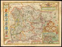
London : Performed by Iohn Speede & are to be sold by John Sudbury & George Humble in Popes head alley at London 1627. as it was devided in the time of the Englishe Saxons especially during their Heptarchy. 1627. Engraved map with hand colouring. A map of Great Britain during the Heptarchy the name given to the period when it was popularly supposed that the island was divided into seven kingdoms: East Anglia Sussex Wessex Northumbria Mercia Kent and Essex. The borders are filled with scenes from the lives of famous British rulers. On the right Peada of Mercia is stabbed through the connivance of his own wife at Easter after converting to Christianity to marry her; at the upper left the semi-mythical Hengist appears who betrayed Vortigern King of the Britons and led the Anglo-Saxon invasion; at the upper right Ethelbert of Kent listens to the preaching of St Augustine who eventually converted him to Christianity. John Speed 1552-1629 was the outstanding cartographer of his age. His ‘Theatre of Great Britain’ was the first atlas of the British Isles: Speed prepared the maps himself about two years before they were published. His maps and books dominated the seventeenth-century English market. The present map is taken from the 1627 English edition published by George Humble. Chubb XXV. Performed by Iohn Speede & are to be sold by John Sudbury & George Humble in Popes head alley at London, unknown
Bookseller reference : 11810

|
|
|
SPEED John
Britain As It Was Devided in the tyme of the Englishe Saxons especially during their Heptarchy
London: are to be sold by Roger Rea ye Elder and younger at ye Golden Crosse in Cornhill against ye Exchange 1665. Performed by Iohn Speede. 1665. Double-page engraved map fine contemporary outline hand colour upper left and right margin skilfully repaired. The map bears the imprint of Roger Rea the Elder and Younger. The Reas had purchased the rights to Speed's work from William Garrett in 1589 who had previously purchased them from the widow of William Humble in the same year. Skelton suggests that the father and son intended a new edition of the atlas for the Restoration of 1660. However the atlas would appear not to have been published until 1665. This is borne out by an advertisement in the Term Catalogue by the subsequent owners of the plates Thomas Bassett and Richard Chiswell in 1675:"Mr John Speed's. Geography of the Kingdoms of England Scotland and Ireland. together with his Prospect. all in one entire Volume hath been for seven Years past out of Print the greatest part of an Impression then newly Printed being destroyed by the late dreadful Fire 1666". This is borne out by the rarity of the Rea edition of the atlas. There is evidence that they planned an edition of 1666 as there are impressions of Sussex Buckingham and Derby with Rea's imprint which bear that date. Rea would later sell the plates to Bassett and Chiswell who would publish a new edition in 1676. Skelton 81. are to be sold by Roger Rea ye Elder and younger at ye Golden Crosse in Cornhill against ye Exchange, unknown
Bookseller reference : 1718

|
|
|
SPEED John 1552 1629.
Britain As It Was Devided in the tyme of the Englishe Saxons especially during their Heptarchy The Theatre of the Empire of Great Britain
London: John Sudbury & George Humble 1676. Single sheet 15 x 20 inches full margins showing the plate mark. A fine uncolored engraved map of Great Britain stretching from the Scottish outer Hebrides in the north west to the coast of France in the south east. Each of the seven Anglo-Saxon kingdoms each decorated with its coat-of-arms are clearly shown on the map. The map was engraved by Jodocus Hondius who is noted for his skills in decoration as demonstrated by the elaborate cartouche and compass rose this map bares. Two columns of vignettes flank the map on each side: the left shows the first king of each Saxon region; the right shows the conversion or their successors to Christianity - through violence inspiration debate and sermons. This map strikes a pleasing balance between the scientific techniques of the time and a historical artistic license. The map was part of the earliest English attempt at producing an atlas on a grand scale as part of Speeds 'The Theatre of the Empire of Great Britain'. This well-known Atlas contained the first detailed maps of the provinces of Ireland the first set of county maps consistently attempting to show the boundaries of territorial divisions and the first truly comprehensive set of English town plans-a notable contribution to British topography. They were an immediate success: three new editions and issues of each appeared during Speed's lifetime and a miniature version was first published about 1619-20. This particular map is a fine example of the array of illustrative features and cartographic detail for which Speed a well-known legend of English cartography is so famous. This map is one of the most desired and recognizable maps on Britain and was later revised and copied by Blaeu and Jansson becoming the basis for subsequent folio atlases until the mid-eighteenth century. Description prepared for Arader Galleries by Jack Rogers Eton College Oxford University Geography Undergraduate . John Sudbury & George Humble unknown
Bookseller reference : 72JR2
|
|
|
Speed John
Britain's Tudor Maps: County by County
B T Batsford Ltd 2017. Hardcover. New. 160 pages. 12.50x17.00x0.50 inches. B T Batsford Ltd hardcover
Bookseller reference : __1849943842 ISBN : 1849943842 9781849943840

|
|
|
SPEED John
Britain's Monarchy. The History of Great Britain Under the Conquests of the Romans Saxons Danes and Normans.
London 1623. old mottled sheep crudely rebacked in black cloth. Binding repaired as noted; some soiling and shallow chipping to the edges of the first few leaves. Folio. Engraved vignettes of British seals etc. This copy lacks the title page; an alternate title page is supplied in pen facsimile in red and black with the date Ann. MDCXI. hardcover
Bookseller reference : 64730
|
|
|
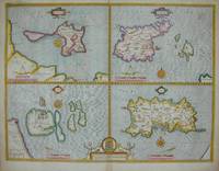
Speed John:
British Islands Holy Island Farne Guernsey Jersey.
London: Basset & Chiswell 1676. Copper engraving 38.5 x 51 cms modern hand-colour four maps on one sheet English text to verso. Islands around the British coast were often grouped in various cominations by early mapmakers. John Speed 1552-1629 is unquestionably the most significant English map-maker of the seventeenth-century. A brief note from Granger�s Bibliographical History of England 1779 contains most of the information we have about Speed�s life: �John Speed who was bred a Tailor was by the generosity of Sir Fulk Grevil his patron set free from a manual employment and enabled to pursue his studies to which he was strongly inclined by the bent of his genius. The fruits of them were his Theatre of Great Britain containing an entire set of maps of the counties drawn by himself his History of Great Britain richly adorned with seals coins & medals from the Cotton collection; and his Genealogies of Scripture first bound up with the Bible in 1611 which was the first edition of the present English translation. His maps were very justly esteemed & his History of Great Britain was in its kind incomparably more complete than all the histories of his predecessors put together �� The first edition of Speed�s �Theatre� was published in 1612. It was the first atlas of the British Isles and the first attempt made by an Englishman to match the achievements of the great continental publishing houses � although much of the engraving of the copper plates was performed in Amsterdam by Jodocus Hondius. Speed was an antiquary and intended that his atlas should be read in conjunction with his history of Britain. He managed to include a great deal of historical detail on his �modern� county maps and the inset town plans some surveyed by himself together comprise the first collection of town plans of the British Isles all in all making the Theatre a highly decorative as well as a useful volume. It was a great success and there were editions printed throughout the seventeenth-century. Map Basset & Chiswell unknown
Bookseller reference : 5122
|
|
|
Speed John F.
British Motor Cars
G.T.Foulis 1952 first edition. No dust jacket the book is in good condition. Red cloth boards marked and bumped. The front hinge is starting to crack owner inscription. Includes "British Cars That Have Made Motoring History" "Some Thoughts On Choosing A Car" "The Role Of The English Small Car" plus eleven other articles and an alphabetical list of British cars. 172 pp. Member of the Independent Online Booksellers Association. G.T.Foulis hardcover
Bookseller reference : # 001038

|
|
|
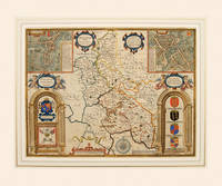
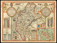
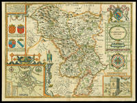
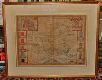
SPEED John
Buckingham Both Shyre and Shire: towne describ.
London: to be sold by Roger Rea ye Elder and younger at ye Golden Crosse in Cornhill against ye Exchange 1665. 1665. Double-page engraved map fine contemporary outline hand colour upper left and right margins skilfully repaired margins reinforced with japan paper. The map bears the imprint of Roger Rea the Elder and Younger. The Reas had purchased the rights to Speed's work from William Garrett in 1589 who had previously purchased them from the widow of William Humble in the same year. Skelton suggests that the father and son intended a new edition of the atlas for the Restoration of 1660. However the atlas would appear not to have been published until 1665. This is borne out by an advertisement in the Term Catalogue by the subsequent owners of the plates Thomas Bassett and Richard Chiswell in 1675:"Mr John Speed's. Geography of the Kingdoms of England Scotland and Ireland. together with his Prospect. all in one entire Volume hath been for seven Years past out of Print the greatest part of an Impression then newly Printed being destroyed by the late dreadful Fire 1666". This is borne out by the rarity of the Rea edition of the atlas. There is evidence that they planned an edition of 1666 as there are impressions of Sussex Buckingham and Derby with Rea's imprint which bear that date. Rea would later sell the plates to Bassett and Chiswell who would publish a new edition in 1676. to be sold by Roger Rea ye Elder and younger at ye Golden Crosse in Cornhill against ye Exchange, unknown
Bookseller reference : 1769

|
|
|
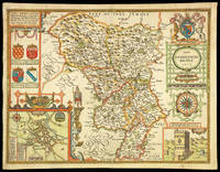
SPEED John.
BUCKINGHAM Both Shyre and Shire towne describ.
Theatre of the Empire of Great Britain. Roger Rea. 1662-1665 English edition. Copper engraving. Later colour. Good condition. Cut close at left and right hand sides but enough added margin for mounting and framing. Top margin strengthened. A closed tear 3 inches runs from the bottom up to the shield of Thomas of Wodstoke on the right. This has an old repair and is scarcely noticeable. Size: 50 x 38 cm. 19½ x 15 inches A beautiful map of Buckinghamshire from Speed's Theatre. Inset plans of the market towns of Buckingham and Redding the latter being a strange choice given that it lies in the county of Berkshire - an indication that the other market towns in Buckinghamshire were not large or prosperous. Embellished with cartouches cherubs and coats of arms belonging to the titled families of the county. Decorated scale at bottom with dividers above and compass rose to the right. Theatre of the Empire of Great Britain. Roger Rea. unknown
Bookseller reference : 54995
|
|
|
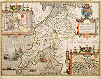
SPEED John
Caermarden
London: Performed by John Speede And are to be sold in Popes head alley against the exchange by John Sudbury and George Humble 1627. Both Shyre and Towne described 1627. Engraved map with hand colouring. A beautifully coloured map of Carmarthenshire with an inset map of Carmarthen. John Speed 1552-1629 was the outstanding cartographer of his age. His ‘Theatre of Great Britain’ was the first atlas of the British Isles: Speed prepared the maps himself about two years before they were published. His maps and books dominated the seventeenth-century English market. The present map is taken from the 1627 English edition published by George Humble. Chubb XXV. Performed by John Speede And are to be sold in Popes head alley against the exchange by John Sudbury and George Humble, unknown
Bookseller reference : 11788

|
|
|
Speed John
Caermarden Carmarthenshire - Both Shyre and Towne Described
John Sudbury & George Humble 1627. Map. Very Good. Soft cover. brightly hand coloured engraved map of 1610 this copy dating from c 1627 inset town plan of Carmarthen large strapwork cartouche compass rose and mileage scale central fold strengthened on verso English text on verso 15" x 20" framed and double glazed ie glazed to front and rear avery good example. Please note if this map is purchased by an overseas buyer it will only be sent out minus frame and glazing. John Sudbury & George Humble Paperback
Bookseller reference : 181593

|
|
|
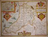
SPEED John.
Caernarvonshire.
London. c1627. Size: 420 x 525 mm. Copperplate engraving with later hand colour. Fair to good condition. Repair to lower centrefold. Margins slim and 'chipped'. John Speed 1552-1629 is arguably the most famous name in early English cartography. In 1610 he published his wonderful and historic atlas 'The Theatre of Great Britain'. In 1627 he published another edition entitled 'A Prospect of The Most Famous Parts of The World' published in London by John Sudbury and George Humble. Speed based his maps on the earlier works done by Christopher Saxton and John Norden. His maps have always been keenly sought after as include many decorative features. Examples include: compass roses cherubs coats of arms mannerist style decoration prominent town plans stylish calligraphy and well defined regional physical features. John Speed's maps proved so popular that they were issued for many years after his death. This decorative and attractive example is of the Welsh county of Caernarvonshire. London. unknown
Bookseller reference : 64225
|
|
|
Speed John:
Cardigan Shyre described with the due forme of the Shiretown as it was surveyed by J.S. Anno 1610.
London: Basset & Chiswell 1676. Copper engraving 39 x 51.5 cms recent hand-colour inset of Cardigan very minor staining on the right-hand side of the map English text on verso. John Speed 1552-1629 is unquestionably the most significant English map-maker of the seventeenth-century. A brief note from Granger's Bibliographical History of England 1779 contains most of the information we have about Speed's life: "John Speed who was bred a Tailor was by the generosity of Sir Fulk Grevil his patron set free from a manual employment and enabled to pursue his studies to which he was strongly inclined by the bent of his genius. The fruits of them were his Theatre of Great Britain containing an entire set of maps of the counties drawn by himself his History of Great Britain richly adorned with seals coins & medals from the Cotton collection; and his Genealogies of Scripture first bound up with the Bible in 1611 which was the first edition of the present English translation. His maps were very justly esteemed & his History of Great Britain was in its kind incomparably more complete than all the histories of his predecessors put together ." The first edition of Speed's "Theatre" was published in 1612. It was the first atlas of the British Isles and the first attempt made by an Englishman to match the achievements of the great continental publishing houses - although much of the engraving of the copper plates was performed in Amsterdam by Jodocus Hondius. Speed was an antiquary and intended that his atlas should be read in conjunction with his history of Britain. He managed to include a great deal of historical detail on his 'modern' county maps and the inset town plans some surveyed by himself together comprise the first collection of town plans of the British Isles all in all making the Theatre a highly decorative as well as a useful volume. It was a great success and there were editions printed throughout the seventeenth-century. Map Basset & Chiswell unknown
Bookseller reference : 5645
|
|
|
Speed John
Counties of Britain : A Tudor Atlas
London U.K: Pavilion 1988. Unopened unclipped. First Edition Thus. Cloth. As New/As New. 4to - over 9�" - 12" tall. Hardback. Pavilion Hardcover
Bookseller reference : 022664 ISBN : 1851451315 9781851451319
|
|
|
Speed John
COUNTIES OF BRITAIN: A Tudor Atlas
Pavilion Books 1992. New edition. Hardcover. Used; Very Good. <p><i><strong>Fast Dispatch. Expedited UK Delivery Available. Excellent Customer Service. </strong></i> <br/><br/>Bookbarn International Inventory #3343341</p> Pavilion Books hardcover
Bookseller reference : 3343341 ISBN : 1851451315 9781851451319
|
|
|
Speed John
Counties of Britain : A Tudor Atlas: Introduction By Nigel Nicolson
GB: Pavilion / British Library 1988. Book is in nearly fine condition with only slightest signs of wear and/or age. Top edge slightly spotted. Dustwrapper/dustjacket is creaed in places with one or two tears. SPECIAL POSTAL RATES APPLY Packed weight. 1600g. 2nd Impression. Hardback. nrFine/VG- DW. Pavilion / British Library Hardcover
Bookseller reference : a015B.003 ISBN : 1851451315 9781851451319
|
|
|
Speed John; Nicolson Nigel Introduction
COUNTIES OF BRITAIN: A Tudor Atlas by John Speed
Pavilion Books 1992-04-09. Hardcover. Very Good/Very Good Jacket. Illustrated. 288 pages Robust recyclable packaging. 1st class post to the UK Airmail worldwide Pavilion Books hardcover
Bookseller reference : 164331 ISBN : 1851451315 9781851451319

|
|
|
Speed John
Counties of Britain: A Tudor Atlas The
US: Trafalgar Square Publishing 1995. 2nd . Softcover. Very Good/None. 288 pages. Extensive color illustrations throughout. Illustrated frontispiece. Slight musty odor. Rubbing to bottom edge. Otherwise clean tight copy. Record # 466897 Trafalgar Square Publishing paperback
Bookseller reference : 466897 ISBN : 1857936124 9781857936124

|
|
|
Speed John
Counties of Britain: A Tudor Atlas
USA: Thames & Hudson 1989. Book is in very good condition with minor signs of wear and/or age. Dustwrapper/dustjacket is in good plus condition with quite noticeable signs of wear and/or age. Clean tight text pages.SPECIAL POSTAGE RATES APPLY GB �5. Packed weight 1650g. Hardback. VG/G DW. Thames & Hudson Hardcover
Bookseller reference : sp003.005 ISBN : 0500251045 9780500251041
|
|
|
SPEED John
Cumberland
London: to be sould by Roger Rea the Elder and younger at the Golden Cross in Cornhill against the Exchange 1665. and the Ancient Citie Carlile Described with Many Memorable Antiquities Therein Found Observed. 1665. Double-page engraved map fine contemporary outline hand colour upper left and right margins skilfully repaired margins reinforced with japan paper. The map bears the imprint of Roger Rea the Elder and Younger. The Reas had purchased the rights to Speed's work form William Garrett in 1589 who had previously purchased them from the widow of William Humble in the same year. Skelton suggests that the father and son intended a new edition of the atlas for the Restoration of 1660. However the atlas would appear not to have been published until 1665. This is borne out by an advertisement in the Term Catalogue by the subsequent owners of the plates Thomas Bassett and Richard Chiswell in 1675:"Mr John Speed's. Geography of the Kingdoms of England Scotland and Ireland. together with his Prospect. all in one entire Volume hath been for seven Years past out of Print the greatest part of an Impression then newly Printed being destroyed by the late dreadful Fire 1666". This is borne out by the rarity of the Rea edition of the atlas. There is evidence that they planned an edition of 1666 as there are impressions of Sussex Buckingham and Derby with Rea's imprint which bear that date. Rea would later sell the plates to Bassett and Chiswell who would publish a new edition in 1676. to be sould by Roger Rea the Elder and younger at the Golden Cross in Cornhill against the Exchange, unknown
Bookseller reference : 1789
|
|
|
SPEED John
Cumberland
London: Performed by Iohn Speed and are to be sould in Popes head Alley by I. Sudbury and Georg. Humble 1627. and the ancient citie Carlile described with many memorable antiquities therein found observed. 1627. Engraved map with hand colouring. A beautifully coloured map of Cumberland now Cumbria. John Speed 1552-1629 was the outstanding cartographer of his age. His ‘Theatre of Great Britain’ was the first atlas of the British Isles: Speed prepared the maps himself about two years before they were published. His maps and books dominated the seventeenth-century English market. The present map is taken from the 1627 English edition published by George Humble. Chubb XXV. Performed by Iohn Speed, and are to be sould in Popes head Alley by I. Sudbury and Georg. Humble, unknown
Bookseller reference : 11762

|
|
|
SPEED John
Darbieshire described
London: to be sold by Roger Rea the Elder and younger at ye Golden Crosse in Cornhill against ye Exchange 1665. 1665. Hand-coloured double-page engraved map upper left and right margins skilfully repaired margins reinforced with japanned paper. The map bears the imprint of Roger Rea the Elder and Younger. The Reas had purchased the rights to Speed's work form William Garrett in 1589 who had previously purchased them from the widow of William Humble in the same year. Skelton suggests that the father and son intended a new edition of the atlas for the Restoration of 1660. However the atlas would appear not to have been published until 1665. This is borne out by an advertisement in the Term Catalogue by the subsequent owners of the plates Thomas Bassett and Richard Chiswell in 1675:"Mr John Speed's. Geography of the Kingdoms of England Scotland and Ireland. together with his Prospect. all in one entire Volume hath been for seven Years past out of Print the greatest part of an Impression then newly Printed being destroyed by the late dreadful Fire 1666". This is borne out by the rarity of the Rea edition of the atlas. There is evidence that they planned an edition of 1666 as there are impressions of Sussex Buckingham and Derby with Rea's imprint which bear that date. Rea would later sell the plates to Bassett and Chiswell who would publish a new edition in 1676. to be sold by Roger Rea the Elder and younger at ye Golden Crosse in Cornhill against ye Exchange, unknown
Bookseller reference : 1781
|
|
|
SPEED John
Darbieshire
London: Performed by John Speede and are to be sold in popes head Alley by Iohn Sudbury and G. Humble 1627. described 1610. 1627. Engraved map with hand colouring. A beautifully coloured map of Derbyshire with insets of the city of Derby and the springs at Buxton. John Speed 1552-1629 was the outstanding cartographer of his age. His ‘Theatre of Great Britain’ was the first atlas of the British Isles: Speed prepared the maps himself about two years before they were published. His maps and books dominated the seventeenth-century English market. The present map is taken from the 1627 English edition published by George Humble. Chubb XXV. Performed by John Speede, and are to be sold in popes head Alley by Iohn Sudbury and G. Humble, unknown
Bookseller reference : 11763
|
|
|
Speed John
De aqua marina commentarius 1755 Leather Bound
2020. Leather Bound. New. Leather Binding on Spine and Corners with Golden Leaf Printing on round Spine extra customization on request like complete leather Golden Screen printing in Front Color Leather Colored book etc. Reprinted in 2020 with the help of original edition published long back 1755. This book is printed in black & white sewing binding for longer life Printed on high quality Paper re-sized as per Current standards professionally processed without changing its contents. As these are old books we processed each page manually and make them readable but in some cases some pages which are blur or missing or black spots. If it is multi volume set then it is only single volume if you wish to order a specific or all the volumes you may contact us. We expect that you will understand our compulsion in these books. We found this book important for the readers who want to know more about our old treasure so we brought it back to the shelves. Hope you will like it and give your comments and suggestions. Lang: - lat Pages 40. EXTRA 10 DAYS APART FROM THE NORMAL SHIPPING PERIOD WILL BE REQUIRED FOR LEATHER BOUND BOOKS. COMPLETE LEATHER WILL COST YOU EXTRA US$ 25 APART FROM THE LEATHER BOUND BOOKS. FOLIO EDITION IS ALSO AVAILABLE. hardcover
Bookseller reference : LB1111017030522
|
|
|
Speed John
De aqua marina commentarius 1755
2020. Softcover. New. Lang: - lat Pages 40. Reprinted in 2020 with the help of original edition published long back 1755. This book is Printed in black & white sewing binding for longer life with Matt laminated multi-Colour Soft Cover HARDCOVER EDITION IS ALSO AVAILABLE Printed on high quality Paper re-sized as per Current standards professionally processed without changing its contents. As these are old books we processed each page manually and make them readable but in some cases some pages which are blur or missing or black spots. If it is multi volume set then it is only single volume if you wish to order a specific or all the volumes you may contact us. We expect that you will understand our compulsion in these books. We found this book important for the readers who want to know more about our old treasure so we brought it back to the shelves. Any type of Customisation is possible. Hope you will like it and give your comments and suggestions. paperback
Bookseller reference : PB1111017030522
|
|
|
Speed John
De aqua marina commentarius 1755 Full Leather Bound
2020. SUPER DELUXE EDITION. New. Antique look with Golden Leaf Printing and embossing with round Spine completely handmade bindingextra customization on request like Color Leather Colored book special gold leaf printing etc. Reprinted in 2020 with the help of original edition published long back 1755. This book is printed in black & white sewing binding for longer life Printed on high quality Paper re-sized as per Current standards professionally processed without changing its contents. As these are old books we processed each page manually and make them readable but in some cases some pages which are blur or missing or black spots. If it is multi volume set then it is only single volume if you wish to order a specific or all the volumes you may contact us. We expect that you will understand our compulsion in these books. We found this book important for the readers who want to know more about our old treasure in old look so we brought it back to the shelves. Hope you will like it and give your comments and suggestions. Lang: - lat Pages 40. EXTRA 10 DAYS APART FROM THE NORMAL SHIPPING PERIOD WILL BE REQUIRED. Normal Hardbound Edition is also available on request. unknown
Bookseller reference : SD1111017030522
|
|
|
Speed John
De Aqua Marina Commentarius: Authore J. Speed M.d. Latin Edition
Nabu Press 2012-01-18. Paperback. Good. Nabu Press paperback
Bookseller reference : SONG127251756X ISBN : 127251756X 9781272517564
|
|
|
SPEED John
Denbighshire
London: Performed by Iohn Speede and are to be solde in Popes head Alley against the exchange by Iohn Sudbury and George Humble 1627. 1627. Engraved map with hand colouring. A beautifully coloured map of Denbighshire with an inset map of Denbigh. John Speed 1552-1629 was the outstanding cartographer of his age. His ‘Theatre of Great Britain’ was the first atlas of the British Isles: Speed prepared the maps himself about two years before they were published. His maps and books dominated the seventeenth-century English market. The present map is taken from the 1627 English edition published by George Humble. Chubb XXV. Performed by Iohn Speede and are to be solde in Popes head Alley against the exchange by Iohn Sudbury and George Humble, unknown
Bookseller reference : 11789

|
|
|
SPEED John
Denmarke
London: Are to be sold in popes-head alley by G. Humble 1631. 1631. Engraved map with hand colouring. A map of Denmark parts of Poland and Norway. The upper border contains views of Copenhagen Helsingør Ribe Schleswig and Hamburg. There are two portrait medallions of Christian IV of Denmark and Norway and his son the Prince-Elect Christian although Speed appears to have amalgamated the Prince-Elect with his younger brother Frederik. The German city of Hamburg is included because of its proximity and thus its position in trade to Denmark. The side borders contain local figures wearing native dress. John Speed 1552-1629 was the outstanding cartographer of his age. His ‘Theatre of Great Britain’ first published in 1611 or 1612 was the first atlas of Great Britain: Speed prepared the maps himself about two years before they were published. This map is from the ‘Prospect of the Most Famous Parts of the World’ produced in collaboration with Speed to accompany the ‘Theatre’ and published in a joint edition by George Humble in 1631. Many of the maps were anglicized versions of works by Dutch makers who introduced the carte-à -figure style with borders of figures in local costume and city views. Chubb XXV. Are to be sold in popes-head alley by G. Humble, unknown
Bookseller reference : 11417

|
|
|
SPEED John
Devonshire with Excester Described
John Sudbury & George Humble 1623. A early edition of Speed's map of Devon. Fabulous later full wash hand colouring. A couple of minor paper flaws add character to this wonderful map which is nearly four hundred years old. Framed and double-glazed to show text on verso in a lovely antique gold style frame. Batten & Bennett 6.4. it may not be possible to post this item in it's frame. English Text Edition. Map. Near Fine. 505 x 380mm. Book. John Sudbury & George Humble
Bookseller reference : 000267
|
|
|
SPEED JOHN:
Dorsetshyre. Original engraved antique map of Dorset. With the Shyre town Dorchester described as also the Armes of such noble families as have bene honored with the Titles thereof since the Normans Conquest to this present Anno 1662 sic.
Published Bassett & Chiswell. Ca 1662. Engraved map with later hand colouring. With printed description of the County of Dorset on back. In hogarth black frame gilt frame with glass to front and back. Double glazed English text on verso. Frame Size 57cm x 44cm. Map size 52cm x 42cm In good condition in good frame. Center fold has a few light creases with small loss lower edge small piece of old tape repair lower rear center fold. Faint colouring. Two small tears with minor loss lower left margin. Map lightly tanned. Frame has a small chip lower right corner. -- Map of Dorset from 1662 with town plan of Dorchester and coats of arms. From John Speed’s ‘Theatre of the Empire of Britain’ originally engraved by Jodocus Hondius with a brief description and history of Dorset with list of Divisions and Hundreds on the back. Published Bassett & Chiswell. Ca 1662 unknown
Bookseller reference : 81350

|
|
|
Speed John:
Dorsetshyre with the Shyre-towne Dorchester described as also the Armes of such noble families as have bene honored with the Titles there of since the Normans conquest to this present.
London c. 1630. Copper engraving 38.5 x 51 cms engraved by Jodocus Hondius modern hand-colour inset plan of Dorchester English text on verso; the date 1662 added by Roger Rea appears on subsequent editions. John Speed 1552-1629 is unquestionably the most significant English map-maker of the seventeenth-century. A brief note from Granger's Bibliographical History of England 1779 contains most of the information we have about Speed's life: "John Speed who was bred a Tailor was by the generosity of Sir Fulk Grevil his patron set free from a manual employment and enabled to pursue his studies to which he was strongly inclined by the bent of his genius. The fruits of them were his Theatre of Great Britain containing an entire set of maps of the counties drawn by himself his History of Great Britain richly adorned with seals coins & medals from the Cotton collection; and his Genealogies of Scripture first bound up with the Bible in 1611 which was the first edition of the present English translation. His maps were very justly esteemed & his History of Great Britain was in its kind incomparably more complete than all the histories of his predecessors put together ." The first edition of Speed's "Theatre" was published in 1612. It was the first atlas of the British Isles and the first attempt made by an Englishman to match the achievements of the great continental publishing houses - although much of the engraving of the copper plates was performed in Amsterdam by Jodocus Hondius. Speed was an antiquary and intended that his atlas should be read in conjunction with his history of Britain. He managed to include a great deal of historical detail on his 'modern' county maps and the inset town plans some surveyed by himself together comprise the first collection of town plans of the British Isles all in all making the Theatre a highly decorative as well as a useful volume. It was a great success and there were editions printed throughout the seventeenth-century. Map unknown
Bookseller reference : 7090

|
|
|
SPEED John.
England Wales Scotland and Ireland Described and Abridged.
London: J. Dawson sould by Georg Humble 1627. Landscape octavo 107 x 162 mm. Recently bound using old vellum tawed leather ties. Housed in a black flat-back cloth box by the Chelsea Bindery. Engraved decorative title engraved "Catalogue of all the Shires" 63 maps complete 2 folding. A few marginal annotations in a 17th-century hand; neat restorations to title map of Northumberland and last leaf paper flaw at fore margin of O4 a couple of maps shaved 3 with early hand-colour Sussex Dorset Essex a couple of leaves a little ragged at fore-edge a few old pale marginal stains yet a very good copy with decent margins and strong impressions of the maps. Second miniature edition of Speed's atlas of Great Britain and Ireland following the edition of 1620. The "farr larger Voulume Done by John Speed" is a reference to the famous Theatre of the Empire of Great Britaine 1611 issued in folio. Thomas Chubb explains that for the first miniature edition of 1620 "forty of the maps are reprints of Peter Keer's maps of 1599 issued at Amsterdam in 1617 for William Camden's Viri clarissimi Britannia. Sixteen are newly engraved maps of some of the English counties which in the earlier editions of 1599 and 1617 were grouped together seven are additional maps". The publisher George Humble was "granted a privilege to print the Theatre for twenty-one years from 1608Â… Speed's Theatre and History of Great Britain were an immediate success: three new editions and issues of each appeared during Speed's lifetime and a miniature version was first published about 1619-20" ODNB. A delightful edition showing the mapped landscape of Britain as it would have been known to Shakespeare. Chubb XII; STC 23035 A2 verso line 14 of text ends "for our". [London: J. Dawson] sould by Georg Humble, hardcover
Bookseller reference : 115052

|
|
|
SPEED John
Essex
London: Described by Iohn Norden augmented by I. Speede And are to be solde by G. Humble 1627. devided into Hundreds with the most antient and fayre Towne Colchester Described and other memorable Monuments observed. Anno 1610. 1627. Engraved map with hand colouring. A map of Essex with an inset map of Colchester and reproductions of three Roman coins or medallions showing Constantine the Great in his dual role as chief priest and emperor and his mother Saint Helena. Saint Helena is the patron saint of Colchester; some British medieval sources claimed she was British and that Constantine was born in the city. Colchester’s coat of arms shown at the upper right corner of the inset map show the relics of the True Cross and the crowns of the Magi which she supposedly found in Jerusalem. John Speed 1552-1629 was the outstanding cartographer of his age. His ‘Theatre of Great Britain’ was the first atlas of the British Isles: Speed prepared the maps himself about two years before they were published. His maps and books dominated the seventeenth-century English market. The present map is taken from the 1627 English edition published by George Humble. Chubb XXV. Described by Iohn Norden, augmented by I. Speede, And are to be solde by G. Humble, unknown
Bookseller reference : 11799

|
|
|
SPEED John
Essex
London: to be solde by Roger Rea ye elder & younger at ye Golden Crosse in Cornhill agt. ye Exchang 1665. devided into Hundreds with the most antient and fayre Towne Colchester Described and other memorable Monuments observed. 1665. Double-page engraved map fine contemporary outline hand colour upper left and right margins skilfully repaired margins reinforced with japan paper. The map bears the imprint of Roger Rea the Elder and Younger. The Reas had purchased the rights to Speed's work from William Garrett in 1589 who had previously purchased them from the widow of William Humble in the same year. Skelton suggests that the father and son intended a new edition of the atlas for the Restoration of 1660. However the atlas would appear not to have been published until 1665. This is borne out by an advertisement in the Term Catalogue by the subsequent owners of the plates Thomas Bassett and Richard Chiswell in 1675:"Mr John Speed's. Geography of the Kingdoms of England Scotland and Ireland. together with his Prospect. all in one entire Volume hath been for seven Years past out of Print the greatest part of an Impression then newly Printed being destroyed by the late dreadful Fire 1666". This is borne out by the rarity of the Rea edition of the atlas. There is evidence that they planned an edition of 1666 as there are impressions of Sussex Buckingham and Derby with Rea's imprint which bear that date. Rea would later sell the plates to Bassett and Chiswell who would publish a new edition in 1676. to be solde by Roger Rea ye elder & younger at ye Golden Crosse in Cornhill agt. ye Exchang, unknown
Bookseller reference : 1761
|
|
|
SPEED John.
Four continents: Africa America Asia Europe.
London. 1627. Engraved maps of the four known continents Framed size: 650 x 755 mm each. Copperplate engraving. Hand coloured. Very good condition slight browning; Africa with central fold tear only affecting margin; America miniscule surface loss to upper left borderline; Europe with minor split and very small loss at foot of central vertical fold. Magnificent set of maps of the four known continents each map dated 1626 but America actually 1631. "Africae described the manners of their habits and buildinge; newly done into English by IS and published at the charges of G Humble" with five national costume figures to both sides and cities to top border title cartouche top right elephants lions hyena ostriches and monkey ships and sea monsters. "America with those known parts in the unknown Worlde" 1st state 2nd issue showing California as an island with five native tribal figures to each side eight panels of city views above with inset map of Greenland upper left title cartouche lower left ships and sea monsters; English text verso with extended fleuron header replacing page no. 9. "Asia with the Islands Adjoining Described" with five national costume figures to each side eight panels of city views above title cartouche upper left the Great Wall of China and an elephant ships and sea monsters. "Europe and the Cheife Cities Contained therein" the continent showing part of Greenland Asia Minor and North Africa with the mythical island of Frisland off Iceland ships and sea monsters; five panels of various national costume figures to each side eight panels of city views above. Set of four maps engraved by Abraham Goos English texts on verso. Published in the 'Prospect of the Most Famous Parts of the World'.998 London. unknown
Bookseller reference : 52184

|
|
|
SPEED John:
Hantshire Described and Divided. Original Antique Engraved Hand Coloured Map of Hampshire. With Plan of Winchester Arms of Nobles and Description of County on rear. Double-Glazed.
London Fleet Street Thomas Bassett 1676. Framed size approx 28 x 23 inches. Engraved surfaces approx 20 x 15 ins. Double-glazed in gold wood frame with ivory mount behind glass. Front and Back. In very good condition. Some darkening/tanning to paper vertical centre crease. Some slight fading to print in some areas. Lovely bright crisp colouring. Very small tear to top l/h corner. Centre fold and edges darkened on rear side. Else a beautiful clean example. Original engraved map with hand colouring. Coloured letterpiece on rear side. London, Fleet Street, Thomas Bassett, 1676 unknown
Bookseller reference : 78599
|
|
|
SPEED John
Hartfordshire
London: Performed by Iohn Speede and are to be sold in Popes head alley by Iohn Sudbury and George Humbell 1627. described the situations of Hartford and the most ancient towne St Albane with such memorable actions as have happened. 1627. Engraved map with hand colouring. A map of Hertfordshire with inset maps of Hertford and the Roman settlement of Verolanium now St Albans. The text underneath refers to Cassivellaunus an Ancient British king who was popularly supposed to have used Verolanium as a stronghold and his defeat by Julius Caesar. John Speed 1552-1629 was the outstanding cartographer of his age. His ‘Theatre of Great Britain’ was the first atlas of the British Isles: Speed prepared the maps himself about two years before they were published. His maps and books dominated the seventeenth-century English market. The present map is taken from the 1627 English edition published by George Humble. Chubb XXV. Performed by Iohn Speede and are to be sold in Popes head alley by Iohn Sudbury and George Humbell, unknown
Bookseller reference : 11800

|
|
|
SPEED John
Herefordshire described
London: to be solde by Roger Rea the Elder and younger at the Golden Crosse in Cornhill against the Exchange 1665. With the true plot of the Citie Hereford as alsoe the Armes of thos Nobles that have bene intituled with that Dignitye. 1665. Double-page engraved map fine contemporary outline hand colour upper left and right margins skilfully repaired margins reinforced with japan paper. The map bears the imprint of Roger Rea the Elder and Younger. The Reas had purchased the rights to Speed's work from William Garrett in 1589 who had previously purchased them from the widow of William Humble in the same year. Skelton suggests that the father and son intended a new edition of the atlas for the Restoration of 1660. However the atlas would appear not to have been published until 1665. This is borne out by an advertisement in the Term Catalogue by the subsequent owners of the plates Thomas Bassett and Richard Chiswell in 1675:"Mr John Speed's. Geography of the Kingdoms of England Scotland and Ireland. together with his Prospect. all in one entire Volume hath been for seven Years past out of Print the greatest part of an Impression then newly Printed being destroyed by the late dreadful Fire 1666". This is borne out by the rarity of the Rea edition of the atlas. There is evidence that they planned an edition of 1666 as there are impressions of Sussex Buckingham and Derby with Rea's imprint which bear that date. Rea would later sell the plates to Bassett and Chiswell who would publish a new edition in 1676. to be solde by Roger Rea the Elder and younger at the Golden Crosse in Cornhill against the Exchange, unknown
Bookseller reference : 1772

|
|
|
SPEED John
Herefordshire
London: Performed by Iohn Speede And are to be solde in Popes head alley against the Exchange by Iohn Sudbury and George Humbell 1627. described with the true plot of the citie of Hereford as alsoe the armes of those nobles that have been intitled with that dignity. 1627. Engraved map with hand colouring. A beautifully coloured map of Herefordshire with an inset of the city of Hereford and a vignette of the Battle of Mortimer’s Cross a key battle in the Wars of the Roses. The picture shows the omen seen before the battle: three suns a phenomenon known as a sundog or parhelion appeared in the sky. John Speed 1552-1629 was the outstanding cartographer of his age. His ‘Theatre of Great Britain’ was the first atlas of the British Isles: Speed prepared the maps himself about two years before they were published. His maps and books dominated the seventeenth-century English market. The present map is taken from the 1627 English edition published by George Humble. Chubb XXV. Performed by Iohn Speede, And are to be solde in Popes head alley against the Exchange by Iohn Sudbury and George Humbell, unknown
Bookseller reference : 11766

|
|
|
SPEED John
Holy Iland; Garnsey; Farne; Jarsey
London: Performed by John Speede and are to be sold by Iohn Sudb. and G. Humbell 1627. Channel Islands 1627. Engraved map with hand colouring. A beautifully coloured map of the Channel Islands. John Speed 1552-1629 was the outstanding cartographer of his age. His ‘Theatre of Great Britain’ was the first atlas of the British Isles: Speed prepared the maps himself about two years before they were published. His maps and books dominated the seventeenth-century English market. The present map is taken from the 1627 English edition published by George Humble. Chubb XXV. Performed by John Speede and are to be sold by Iohn Sudb. and G. Humbell, unknown
Bookseller reference : 11782

|
|
|
SPEED John
Ireland
London: Sudbury and Humble 1627. 1627. Engraved map with hand colouring. A map of Ireland with pictures showing the costume of different levels of society including a pair of “wilde†Irish who wear dyed skins. John Speed 1552-1629 was the outstanding cartographer of his age. His ‘Theatre of Great Britain’ was the first atlas of the British Isles: Speed prepared the maps himself about two years before they were published. His maps and books dominated the seventeenth-century English market. The present map is taken from the 1627 English edition published by George Humble. Chubb XXV. Sudbury and Humble, unknown
Bookseller reference : 11807

|
|
|
Speed John:
Italia Newly augmented by I: Speede and Are to bee sold in Pops - head aley by George Humble. 1626
2013. George Hulmble auf Leinen aufgezogene Papierplatten Faksimilierte handkolorierte Italien Karte von John Speed verlegt von George Humble 1626 Abmessungen: ca 90 x 70 cm Auf Leinen aufgezogen. Es handelt sich um eine hochwertige dekorative faksimilierte handkolorierte Speed Karte. John Speed 1551 oder 1552 � 28 Juli 1629 war ein Englischer Kartograph und Historiker. Er ist der bekannteste Kartenhersteller der Stuart Periode. Er wird auch der "Englische Mercator" genannt. Sourc. Wik. Landkarten unknown
Bookseller reference : 2

|
|
|
Speed John
John Speed's England. Part IV. Lincolnshire Nottinghamshire . Durham . Northumberland
London: Phoenix House Limited. VG : in very good condition without dust jacket. Light shelfwear. Occasional foxing. 1954. Facsimile edition. Half cloth hardback with decorated paper covered boards. 470mm x 310mm 19" x 12". 40pp. Colour reproductions of the 1611 edition. . Phoenix House Limited hardcover
Bookseller reference : e8002d

|
|
|
SPEED JOHN.
John Speed's England. A coloured Facsimile of the Maps and text from the Theatre of the Empire of Great Britaine. First Edtion 1611.
London Phoenix House Limited 1953-54. Folio. 4 orig. hcloth all in orig. slicase. Fine and clean. Text and fine facsimile-maps in colour. hardcover
Bookseller reference : 49146
|
|
|
Speed John
John Speed's Atlas of Wales: Part II
S.R. Publishers 1970. First Edition. Hardcover. Very Good/Very Good. Publisher's hardback in very good condition: firm square and tight with no snags or splits just a trifle rubbed. Complete with original dustjacket: in decent shape just slightly rubbed and moderately edge-worn. Contents sound and clean; no pen-marks. Not from a library so no such stamps or labels. Thus a tidy book in presentable condition. S.R. Publishers hardcover
Bookseller reference : 086839 ISBN : 0854096140 9780854096145
|
|
|
Speed John
John Speed's England. A coloured facsimile of the first edition. Edited by John Arlott. Parts One Three and Four ONLY
London: Phoenix House Limited 1954. First edition. Illustrated. 3 vols. Folio. Three-quarter cloth patterned boards paper labels. Near Fine 3 in slipcases. First edition. Illustrated. 3 vols. Folio. Phoenix House Limited unknown
Bookseller reference : 223986
|
|
|
Speed John / EGR. Taylor intro. & description E. G.
John Speed's Atlas of England & Wales
London: King Penguin 1951. Very minor soiling to dust jacket - no tears. The book within is pristine. Fine/Near Fine. King Penguin unknown
Bookseller reference : 805
|
|
|
SPEED John
Kent
London: and Are to be sold by Roger Rea the Elder and younger at ye Golden Crosse in Cornhill aga.st ye Exchange 1665. with her Cities and Earles described and observed. Performed by Iohn Speede 1665. Double-page engraved map fine contemporary outline hand colour upper left and right margin skilfully repaired top margin trimmed to neatline. The map bears the imprint of Roger Rea the Elder and Younger. The Reas had purchased the rights to Speed's work from William Garrett in 1589 who had previously purchased them from the widow of William Humble in the same year. Skelton suggests that the father and son intended a new edition of the atlas for the Restoration of 1660. However the atlas would appear not to have been published until 1665. This is borne out by an advertisement in the Term Catalogue by the subsequent owners of the plates Thomas Bassett and Richard Chiswell in 1675:"Mr John Speed's. Geography of the Kingdoms of England Scotland and Ireland. together with his Prospect. all in one entire Volume hath been for seven Years past out of Print the greatest part of an Impression then newly Printed being destroyed by the late dreadful Fire 1666". This is borne out by the rarity of the Rea edition of the atlas. There is evidence that they planned an edition of 1666 as there are impressions of Sussex Buckingham and Derby with Rea's imprint which bear that date. Rea would later sell the plates to Bassett and Chiswell who would publish a new edition in 1676. and Are to be sold by Roger Rea the Elder and younger at ye Golden Crosse in Cornhill aga.st ye Exchange, unknown
Bookseller reference : 1750

|
|
|
SPEED John
Kent
London: Performed by IOhn Speede and Are to be sold by G. Humble in popes head Alley 1627. with her cities and earles described and observed. 1627. Engraved map with hand colouring. A map of Kent with inset maps of Rochester and Canterbury. John Speed 1552-1629 was the outstanding cartographer of his age. His ‘Theatre of Great Britain’ was the first atlas of the British Isles: Speed prepared the maps himself about two years before they were published. His maps and books dominated the seventeenth-century English market. The present map is taken from the 1627 English edition published by George Humble. Chubb XXV. Performed by IOhn Speede and Are to be sold by G. Humble in popes head Alley, unknown
Bookseller reference : 11801

|
|
 Receive by email
 Download as PDF document
 RSS feed


