|
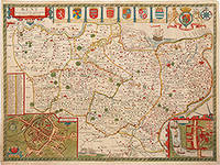
SPEED John; Jodocus Hondius engr.
Kent with her Cities and Earles described and observed.
The Theatre of the Empire of Great Britain. T Bassett & R Chiswell. 1676. Copper engraving. Hand coloured. Very good condition. Sheet size: 395 x 510 mm. Mount size: 590 x 705 mm A beautiful map of Kent based on the work of Philip Symonson. Insets of the cathedral cities of Canterbury and Rochester and seven coats of arms. Due to Kent's extensive coastline and proximity to France and the Netherlands it had unrivalled advantages for trade thus making its defence imperative. Dover Castle had long been a linchpin in the defence of the realm but most other castles in Kent were made redundant when a series of modern artillery forts like Deal and Walmer were constructed in the 1540's by Henry VIII. These were to protect the anchorage of the Downs which the Navy had recently taken to using. The adoption of other fleet-anchorages along the Thames and the Medway and the establishment of dockyards at Deptford and Woolwich by Henry VIII and at Chatham by Elizabeth I turned Kent into the best defended area in the kingdom throughout the Tudor and early Stuart periods. Ref. Nigel Nicolson: A Tudor Atlas by John Speed. Nigel Nicolson A Tudor Atlas by John Speed The Theatre of the Empire of Great Britain. T Bassett & R Chiswell. unknown
Bookseller reference : 80193
|
|
|
SPEED John
Leicester
London: Performed by John Speede and are to be sold in popes head Alley by John Sudbury and George Humble 1627. both county and citie described the honourable families that have the titles of Earls thereof with other accidents therein observed. 1627. Engraved map with hand colouring. A beautifully coloured map of Leicestershire with an inset map of Leicester and a vignette with text showing the Battle of Bosworth the climatic engagement of the Wars of the Roses in 1485. John Speed 1552-1629 was the outstanding cartographer of his age. His ‘Theatre of Great Britain’ was the first atlas of the British Isles: Speed prepared the maps himself about two years before they were published. His maps and books dominated the seventeenth century English market. The present map is taken from the 1627 English edition published by George Humble. Chubb XXV. Performed by John Speede, and are to be sold in popes head Alley by John Sudbury and George Humble, unknown
Bookseller reference : 11768

|
|
|
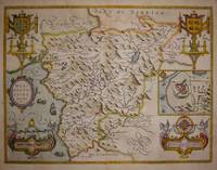
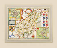
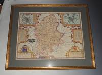
SPEED John.
Merionethshire.
London. c1627. Size:420 x 545 mm. Copperplate engraving with later hand colour. Fair condition. Map has had repairs to lower centrefold and margin. General toning. John Speed 1552-1629 is arguably the most famous name in early English cartography. In 1610 he published his wonderful and historic atlas 'The Theatre of Great Britain'. In 1627 he published another edition entitled 'A Prospect of The Most Famous Parts of The World' published in London by John Sudbury and George Humble. Speed based his maps on the earlier works done by Christopher Saxton and John Norden. His maps have always been keenly sought after as include many decorative features. Examples include: compass roses cherubs coats of arms mannerist style decoration prominent town plans calligraphy and well defined regional physical features. John Speed's maps proved so popular that they were issued for many years after his death. This example is of the Welsh county of Merionethshire. London. unknown
Bookseller reference : 64226
|
|
|
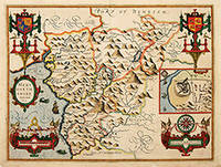
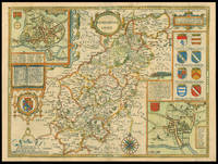
Speed John:
Merionethshire
London: Basset & Chiswell 1676. Copper engraving 39 x 51.5 cms recent hand-colour inset town-plan of Harlech light waterstaining to the upper part of the map English text on verso. John Speed 1552-1629 is unquestionably the most significant English map-maker of the seventeenth-century. A brief note from Granger's Bibliographical History of England 1779 contains most of the information we have about Speed's life: "John Speed who was bred a Tailor was by the generosity of Sir Fulk Grevil his patron set free from a manual employment and enabled to pursue his studies to which he was strongly inclined by the bent of his genius. The fruits of them were his Theatre of Great Britain containing an entire set of maps of the counties drawn by himself his History of Great Britain richly adorned with seals coins & medals from the Cotton collection; and his Genealogies of Scripture first bound up with the Bible in 1611 which was the first edition of the present English translation. His maps were very justly esteemed & his History of Great Britain was in its kind incomparably more complete than all the histories of his predecessors put together ." The first edition of Speed's "Theatre" was published in 1612. It was the first atlas of the British Isles and the first attempt made by an Englishman to match the achievements of the great continental publishing houses - although much of the engraving of the copper plates was performed in Amsterdam by Jodocus Hondius. Speed was an antiquary and intended that his atlas should be read in conjunction with his history of Britain. He managed to include a great deal of historical detail on his 'modern' county maps and the inset town plans some surveyed by himself together comprise the first collection of town plans of the British Isles all in all making the Theatre a highly decorative as well as a useful volume. It was a great success and there were editions printed throughout the seventeenth-century. Map Basset & Chiswell unknown
Bookseller reference : 5646
|
|
|
SPEED John
Midle-Sex
George Humble. First. unbound. Miniature Map. Engraving. 3 1/4" x 4 1/4" Rare undated first edition of John Speed's map of Middlesex County from "Theatre" in miniature. Includes lovely rendering of London. John Speed 1552-1629 born in Cheshire and a tailor by profession until he was 50 is widely considered to be the most famous English cartographer of the 17th century. He is noted for placing England in the mainstream of map publishing an industry which was at the time dominated by the Dutch. His atlas "The Theatre of the Empire of Great Britaine" contained the first set of individual county maps of England and Wales as well as significant town plans that are in many cases the first visual records of their subjects. George Humble unknown
Bookseller reference : 279246

|
|
|
Speed John after Norden John
MIDLE-SEX DESCRIBED WITH THE MOST FAMOUS CITIES OF LONDON AND WESTMINSTER
<p>London: c. 1627. A fine impression. 15†x 20â€-38.1 x 50.8 cm. Skelton #17 A classic early view of the county of Middlesex from the first comprehensive atlas of English town plans. Insets of Westminster and London upper left and right respectively after Keere. Lower left is a view of Saint Peters and lower right Saint Pauls. Textural description of both cathedrals are whimsically engraved in vignettes of books.</p>
Bookseller reference : 1250

|
|
|
SPEED John
Montgomery
London: Described by Christopher Saxton augmented and published by John Speed and are to be sold in Popes head alley against the Exchange of London by John Sudbury and George Humbell 1627. 1627. Engraved map with hand colouring. A beautifully coloured map of the historic county of Montgomeryshire with an inset map of Montgomery. John Speed 1552-1629 was the outstanding cartographer of his age. His ‘Theatre of Great Britain’ was the first atlas of the British Isles: Speed prepared the maps himself about two years before they were published. His maps and books dominated the seventeenth-century English market. The present map is taken from the 1627 English edition published by George Humble. Chubb XXV. Described by Christopher Saxton, augmented and published by John Speed, and are to be sold in Popes head alley against the Excha unknown
Bookseller reference : 11793

|
|
|
Speed John; Elstrack Renold
Norfolk a Countie Florishing & Populous Desccribed and Devided with the Armes of Such Noble Familes as Have Borne the Titles Therof; Discribed by Christopher Saxton; Augmented by I. Speede map
London: George Humble 1627. Map. Very Good. "Are to be sold in popes head Alley by J. S. & G. H." "R. Elstrack sculpsit." 1 hand-colored copperplate engraving 41 x 55 cm. from Book One of John Speed's Theatre of the Empire of Great Britaine London: George Humble 1627. See: STC 2nd ed. 23042. A detailed map of Norfolk County with inset illustrations of a battle in the Peasant's Revolt in 1381 and of the town of Norwich. The town plan of Norwich includes a guide to 24 locations in the town. Above the map is the royal coat of arms of the United Kingdom; along one side are seven coats of arms of Norfolk families. text on the reverse describes Norfolk and lists the hundreds. In Very Good Condition: minor loss along upper edge not impacting image; just starting to separate at lower end of center fold; colors are bright; a clean and crisp map. <br/><br/> George Humble unknown
Bookseller reference : 006728
|
|
|
SPEED John.
Northamptonshire
Theatre of the Empire of Great Britain published by Bassett and Chiswell. c.1627. Copper engraving. Hand coloured. Fine condition; wide margins. Mounted size: 71.5 x 60 cm Size: 51 x 38.5 cm. 20 x 15 inches A highly decorative Speed's map with coats of arms of all the families that were made earls of Northampton following the Norman conquest. Insets showing a townplan of Northampton with related text and plan of Peterborough and a vignette of the Battle of Egdecot in 1469 together with a section of text First published in 1611 today the work of John Speed is regarded highly by map collectors historians and artists due to the intricate nature and artistic beauty of the maps. Theatre of the Empire of Great Britain, published by Bassett and Chiswell. unknown
Bookseller reference : 57317
|
|
|
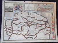
SPEED John
Northamtonshire
London: to be sold by Roger Rea the Elder and younger at the Golden Crosse in Cornhill against ye Exchange 1665. 1665. Double-page engraved map fine contemporary outline hand colour upper left and right margins skilfully repaired margins reinforced with japan paper. The map bears the imprint of Roger Rea the Elder and Younger. The Reas had purchased the rights to Speed's work from William Garrett in 1589 who had previously purchased them from the widow of William Humble in the same year. Skelton suggests that the father and son intended a new edition of the atlas for the Restoration of 1660. However the atlas would appear not to have been published until 1665. This is borne out by an advertisement in the Term Catalogue by the subsequent owners of the plates Thomas Bassett and Richard Chiswell in 1675:"Mr John Speed's. Geography of the Kingdoms of England Scotland and Ireland. together with his Prospect. all in one entire Volume hath been for seven Years past out of Print the greatest part of an Impression then newly Printed being destroyed by the late dreadful Fire 1666". This is borne out by the rarity of the Rea edition of the atlas. There is evidence that they planned an edition of 1666 as there are impressions of Sussex Buckingham and Derby with Rea's imprint which bear that date. Rea would later sell the plates to Bassett and Chiswell who would publish a new edition in 1676. to be sold by Roger Rea the Elder and younger at the Golden Crosse in Cornhill against ye Exchange, unknown
Bookseller reference : 1775

|
|
|
SPEED John
Northamtonshire
London: Performed by Iohn Speede and are to be sold by George Humble in ye Popes head alley 1627. 1627. Engraved map with hand colouring. A beautifully coloured map of Northamptonshire with inset maps of Northampton and Peterborough and a vignette with text of the Battle of Edgecote Moor where Richard Neville Duke of Warwick defeated Edward IV during the Wars of the Roses. John Speed 1552-1629 was the outstanding cartographer of his age. His ‘Theatre of Great Britain’ was the first atlas of the British Isles: Speed prepared the maps himself about two years before they were published. His maps and books dominated the seventeenth-century English market. The present map is taken from the 1627 English edition published by George Humble. Chubb XXV. Performed by Iohn Speede and are to be sold by George Humble in ye Popes head alley, unknown
Bookseller reference : 11770
|
|
|
SPEED JOHN:
Original Engraved Hand Coloured Map of Shropshire. Described the Sittuation of Shrowesbury shewed With the Arms of thos Earles and other things observed.
Speed / George Humbell 1611 1st edition. Original Engraved Hand Coloured Double-Sided Map. Mounted and framed in double glazed gold frame glass front and back. Map size 20 x 15 inches. Total size 29 x 24 inches. In very good condition. Vertical crease to centre. Some very light browning to l/h side with a couple of marks to margin. Else a very clean and bright 1st edition map. 1st edition shows dotting around the decorative paragraph header on verso. Beautifully hand coloured with description and list of Towns to verso. Speed / George Humbell 1611 1st edition unknown
Bookseller reference : 76834

|
|
|
SPEED JOHN:
Original Engraved Hand Coloured Map of Stafford. Countie and Towne with the Ancient Citie LITCHFIELD described.
Speed / George Humble ca1610-1614. Original Engraved Hand Coloured Double-Sided Map. Mounted and framed in double glazed gold frame glass front and back. Map size 20 x 15 inches. Total size 26 x 21 inches. In very good condition. Vertical crease to centre. A very clean and bright example. Beautifully hand coloured with description and list of Towns to verso. Speed / George Humble ca1610-1614 unknown
Bookseller reference : 76833
|
|
|
SPEED John.
Oxfordshire.
London. 1627. Size: 395 x 535 mm. Copperplate engraving with later hand colouring. Fair condition. Some old repairs to lower central fold. Slight discolouration to the central fold. A handsome early Sudbury and Humble edition of John Speed's map of Oxfordshire in colour. Towns and cities are highlighted in red decorative college arms and the supposed years of their foundation are found on either side of the map. A detailed inset map of the city of Oxford is in the upper right corner with a separate key with 28 listed city landmarks. The arms of the earl of Oxford to the right. Two academic university figures are seen standing with a pair of compass dividers either side of a striking globe representing the scale of miles. A strapwork border design and the royal coat of arms complete this map wonderfully well. London. unknown
Bookseller reference : 64885

|
|
|
SPEED John
Persia
London: Are to be sold in Pops-head alley by G. Humble 1631. The Kingdome of Persia with the chief cities and Habites described 1631. Engraved map with hand colouring. A map of the Middle East with a decorative border showing the costumes of different regions and views of principal cities. John Speed 1552-1629 was the outstanding cartographer of his age. His ‘Theatre of Great Britain’ first published in 1611 or 1612 was the first atlas of Great Britain: Speed prepared the maps himself about two years before they were published. This map is from the ‘Prospect of the Most Famous Parts of the World’ produced in collaboration with Speed to accompany the ‘Theatre’ and published in a joint edition by George Humble in 1631. Many of the maps were anglicized versions of works by Dutch makers who introduced the carte-à -figure style with borders of figures in local costume and city views. Chubb XXV. Are to be sold in Pops-head alley by G. Humble, unknown
Bookseller reference : 11405

|
|
|
SPEED John
Set of the world and continents
London: George Humble 1631. 1631. Engraved maps with hand colouring. A set of five maps comprising a world map and maps of the four known continents. The world map is on a double hemispheric projection in a simple strapwork border with two smaller celestial maps between. The centre is decorated with personifications of the four elements and the corners with astronomical information and diagrams. Four cartouches hold portraits of famous explorers with an English bias: Sir Francis Drake Ferdinand Magellan Thomas Cavendish and Olivier van Noort. Each of the continent maps is surrounded by a border containing views of the principal cities and local people in native costume. John Speed 1552-1629 was the outstanding cartographer of his age. His ‘Theatre of Great Britain’ first published in 1611 or 1612 was the first atlas of Great Britain: Speed prepared the maps himself about two years before they were published. These maps are from the ‘Prospect of the Most Famous Parts of the World’ produced in collaboration with Speed to accompany the ‘Theatre’ and published in a joint edition by George Humble in 1631. Many of the maps were anglicized versions of works by Dutch makers who introduced the carte-à -figure style with borders of figures in local costume and city views. Chubb XXV. George Humble, unknown
Bookseller reference : 11414

|
|
|
Speed John
Shropshyre Described: The Situation of Shrowesbury Shewed with the Armies of Thos Earles and Other Memorable Things Observed
Publisher Not Stated. Undated facsimile reprint of map of Shropshire originally issued in the early 1600s. . Very Good. Folded Map. Facsimile Reprint. Publisher Not Stated unknown
Bookseller reference : 134965
|
|
|
Speed John Gilmer
Signed dated MS JG Speed to Dodd Mead & Company 6/20/1883
New York: Speed & Dodd Mead 1883. 8vo. Single Page Very Good with small tear minor creasing rubbing edge wear & some stains. New York: Speed & Dodd Mead, 1883 unknown
Bookseller reference : 15-5100
|
|
|
SPEED John & Henry Overton.
Somerset-shire.
London. c1713-43. Mount size: 560 x 680 mm. Copperplate engraving. Good condition slighty age toned slight tear to engraved surface. Henry Overton acquired the famous John Speed county map copperplates from Christopher Browne sometime before 1713. Soon after he re-engraved the maps using his own imprint of "Sold by Henry Overton at the White Horse without Newgate London" and re-issued the maps under the atlas title of "England fully described in a compleat sett of mapps of ye count's of England". Apart from the new imprint the most obvious changes made by Overton was the addition of engraving major county roads. This is his example of Somerset. London. unknown
Bookseller reference : 69944

|
|
|
SPEED John
Spaine
London: Are to be sould by George Humble in pops-head alley against the Exchange 1631. 1631. Engraved map with colouring. A map of Spain with a decorative border containing depictions of Spaniards in regional costume. The Balearics appear marked as the ‘Pyne Ilands’. John Speed 1552-1629 was the outstanding cartographer of his age. His ‘Theatre of Great Britain’ first published in 1611 or 1612 was the first atlas of Great Britain: Speed prepared the maps himself about two years before they were published. This map is from the ‘Prospect of the Most Famous Parts of the World’ produced in collaboration with Speed to accompany the ‘Theatre’ and published in a joint edition by George Humble in 1631. Many of the maps were anglicized versions of works by Dutch makers who introduced the carte-à -figure style with borders of figures in local costume and city views. Chubb XXV. Are to be sould by George Humble in pops-head alley against the Exchange, unknown
Bookseller reference : 11413

|
|
|
SPEED John. Engraved by HONDIUS Jodocus.
SUFFOLKE described and divided into Hundreds
The Theatre of the Empire of Great Britain. T Bassett & R Chiswell. 1676. Copper engraving. Hand coloured. Fine condition good margins but some slight offsetting. Mounted size: 72 x 60 cm. Size: 51 x 38 cm. 20 x 15 inches. A very attractive map of Suffolk with inset of Ipswich enclosed in an elegant border. On the right of this is a pictorial reference to Bodicia Queen of the Iceni who occupied the area today known as East Anglia. On the left stands a Roman General. Numerous coats of arms of the Dukes and Earles of Suffolk and Clare adorn either side. At the bottom left a cherub holds dividers over the scale on the right a cupid holds a wind rose. The Theatre of the Empire of Great Britain. T Bassett & R Chiswell. unknown
Bookseller reference : 53206

|
|
|
SPEED John
Surrey
London: Are to be solde in popes-head Alley against the exchange by John Sudbury and George Humble 1627. described and divided into hundreds. 1627. Engraved map with hand colouring. A map of Surrey with inset views of the palaces of Richmond and Nonsuch both royal Tudor residences which were demolished by the end of the seventeenth century. Nonsuch was given by Charles II to Barbara Countess of Castlemaine who then tore it apart to pay gambling debts; Richmond was sold by Parliament after the execution of Charles I. John Speed 1552-1629 was the outstanding cartographer of his age. His ‘Theatre of Great Britain’ was the first atlas of the British Isles: Speed prepared the maps himself about two years before they were published. His maps and books dominated the seventeenth-century English market. The present map is taken from the 1627 English edition published by George Humble. Chubb XXV. Are to be solde in popes-head Alley against the exchange by John Sudbury and George Humble, unknown
Bookseller reference : 11803

|
|
|
SPEED John
Surrey Described and Divided into Hundreds
London: to be solde by Roger Rea the elder and younger at the Golden Crosse in Cornhill against the Exchange 1665. 1665. Double-page engraved map with fine contemporary outline hand colour upper left and right margins skilfully repaired margins reinforced with japan paper. The map bears the imprint of Roger Rea the Elder and Younger. The Reas had purchased the rights to Speed's work from William Garrett in 1589 who had previously purchased them from the widow of William Humble in the same year. Skelton suggests that the father and son intended a new edition of the atlas for the Restoration of 1660. However the atlas would appear not to have been published until 1665. This is borne out by an advertisement in the Term Catalogue by the subsequent owners of the plates Thomas Bassett and Richard Chiswell in 1675:"Mr John Speed's. Geography of the Kingdoms of England Scotland and Ireland. together with his Prospect. all in one entire Volume hath been for seven Years past out of Print the greatest part of an Impression then newly Printed being destroyed by the late dreadful Fire 1666". This is borne out by the rarity of the Rea edition of the atlas. There is evidence that they planned an edition of 1666 as there are impressions of Sussex Buckingham and Derby with Rea's imprint which bear that date. Rea would later sell the plates to Bassett and Chiswell who would publish a new edition in 1676. to be solde by Roger Rea the elder and younger at the Golden Crosse in Cornhill against the Exchange unknown
Bookseller reference : 1753

|
|
|
SPEED John
Sussex
London: Described by Iohn Norden Augmented by John Speede And are to be sole in popes head Alley against the Exchange by I.S. and George Humble 1627. described and divided into rapes with the situation of Chichester the chiefe citie thereof and the armes of Nobles as have bene dignified with the title of Earles since the conquest and other accidents therein observed. 1627. Engraved map with hand colouring. A map of Sussex with an inset map of Chichester and a vignette of and text about the Battle of Hastings between Harold Godwinsson and William the Conqueror to whom Speed gives the earthier name of William the Bastard. William’s fleet is visible in the Channel. John Speed 1552-1629 was the outstanding cartographer of his age. His ‘Theatre of Great Britain’ was the first atlas of the British Isles: Speed prepared the maps himself about two years before they were published. His maps and books dominated the seventeenth-century English market. The present map is taken from the 1627 English edition published by George Humble Chubb XXV. Described by Iohn Norden, Augmented by John Speede And are to be sole in popes head Alley against the Exchange by I.S. and Georg unknown
Bookseller reference : 11804

|
|
|
SPEED John
Sussex
London: And are to be sold by Roger Rea the Elder and younger at the Golden Crosse in Cornhill against the Exchange 1665. Described and divided into Rapes with the situation of the Chichester the cheife citie thereof. And the armes of such Nobles as have bene dignified with the title of Earles since the conquest and other accidents therein observed. Described by Iohn Norden. Augmented by Iohn Speede 1665. Double-page engraved map fine contemporary outline hand colour upper left and right margins skilfully repaired. The map bears the imprint of Roger Rea the Elder and Younger. The Reas had purchased the rights to Speed's work from William Garrett in 1589 who had previously purchased them from the widow of William Humble in the same year. Skelton suggests that the father and son intended a new edition of the atlas for the Restoration of 1660. However the atlas would appear not to have been published until 1665. This is borne out by an advertisement in the Term Catalogue by the subsequent owners of the plates Thomas Bassett and Richard Chiswell in 1675:"Mr John Speed's. Geography of the Kingdoms of England Scotland and Ireland. together with his Prospect. all in one entire Volume hath been for seven Years past out of Print the greatest part of an Impression then newly Printed being destroyed by the late dreadful Fire 1666". This is borne out by the rarity of the Rea edition of the atlas. There is evidence that they planned an edition of 1666 as there are impressions of Sussex Buckingham and Derby with Rea's imprint which bear that date. Rea would later sell the plates to Bassett and Chiswell who would publish a new edition in 1676. And are to be sold by Roger Rea the Elder and younger at the Golden Crosse in Cornhill against the Exchange, unknown
Bookseller reference : 1751

|
|
|
SPEED John:
THE COUNTIES OF BRITAIN.
London. Pavilion. 1995. Large format paperback. Fine in a fine papercover. No markings or inscriptions. London. Pavilion. 1995. paperback
Bookseller reference : 9143
|
|
|
SPEED John
The Bishopric and Citie of Durham
London 1627. 1627. Engraved map with hand colouring. A beautifully coloured map of County Durham with an inset of the city of Durham and a tableau and text cartouche explaining the battle of Neville’s Croft in 1346 when David II of Scotland was prevented from advancing into England. John Speed 1552-1629 was the outstanding cartographer of his age. His ‘Theatre of Great Britain’ was the first atlas of the British Isles: Speed prepared the maps himself about two years before they were published. His maps and books dominated the seventeenth-century English market. The present map is taken from the 1627 English edition published by George Humble. Chubb XXV. unknown
Bookseller reference : 11765

|
|
|
Speed John George Kohler Collection of British Poetry
The borderer's leap : and other poems 1869 Leather Bound
2019. Leather Bound. New. Leather Binding on Spine and Corners with Golden Leaf Printing on round Spine. Reprinted in 2019 with the help of original edition published long back 1869. This book is printed in black & white sewing binding for longer life Printed on high quality Paper re-sized as per Current standards professionally processed without changing its contents. As these are old books we processed each page manually and make them readable but in some cases some pages which are blur or missing or black spots. If it is multi volume set then it is only single volume if you wish to order a specific or all the volumes you may contact us. We expect that you will understand our compulsion in these books. We found this book important for the readers who want to know more about our old treasure so we brought it back to the shelves. Hope you will like it and give your comments and suggestions. Lang: - eng Pages 94. EXTRA 10 DAYS APART FROM THE NORMAL SHIPPING PERIOD WILL BE REQUIRED FOR LEATHER BOUND BOOKS. FOLIO EDITION IS ALSO AVAILABLE. hardcover
Bookseller reference : LB1111001703647

|
|
|
Speed John George Kohler Collection of British Poetry
The borderer's leap : and other poems 1869
2020. Paperback. New. Lang: - eng Pages 94. Reprinted in 2020 with the help of original edition published long back 1869. This book is Printed in black & white sewing binding for longer life with Matt laminated multi-Colour Soft Cover HARDCOVER EDITION IS ALSO AVAILABLE Printed on high quality Paper re-sized as per Current standards professionally processed without changing its contents. As these are old books we processed each page manually and make them readable but in some cases some pages which are blur or missing or black spots. If it is multi volume set then it is only single volume if you wish to order a specific or all the volumes you may contact us. We expect that you will understand our compulsion in these books. We found this book important for the readers who want to know more about our old treasure so we brought it back to the shelves. Any type of Customisation is possible with extra charges. Hope you will like it and give your comments and suggestions. paperback
Bookseller reference : PB1111001703647
|
|
|
Speed John George Kohler Collection of British Poetry
The borderer's leap : and other poems 1869 Hardcover
2020. Hardcover. New. Lang: - eng Pages 94. Reprinted in 2020 with the help of original edition published long back 1869. This book is Printed in black & white Hardcover sewing binding for longer life with Matt laminated multi-Colour Dust Cover Printed on high quality Paper re-sized as per Current standards professionally processed without changing its contents. As these are old books we processed each page manually and make them readable but in some cases some pages which are blur or missing or black spots. If it is multi volume set then it is only single volume if you wish to order a specific or all the volumes you may contact us. We expect that you will understand our compulsion in these books. We found this book important for the readers who want to know more about our old treasure so we brought it back to the shelves. Any type of Customisation is possible with extra charges. Hope you will like it and give your comments and suggestions. hardcover
Bookseller reference : 1111001703647
|
|
|
Speed John
The Counter-Scuffle. Whereunto is Added the Counter-Rat Written By R.S
London: for R. Scot T. Baffet 1680. LATER EDITION. Small 4to. 54pp.i disbound recto of title-page repaired illustrated with two engravings one of which is a title-page vignette foredge of title-page chipped not affecting image or text. The poem celebrates a brawl in the Wood Street Compter or debtors' prison. The title-page vignette a copperplate illustrates a brawl; the other plate a full-page woodcut shows a scene at the gate of the prison. The date of the first edition of this work is uncertain but circa 1628 is guessed.rnWing S4896; Lowndes 2164; Grolier Whither to Prior 771. London: for R. Scot, T. Baffet, unknown
Bookseller reference : mon0000023721

|
|
|
Speed John
The Counties of Britain: A Tudor Atlas
Pavilion Books. Used - Like New. Ships from Reno NV. Book in almost Brand New condition. 100% Money Back Guarantee. Shipped to over one million happy customers. Your purchase benefits world literacy! Pavilion Books unknown
Bookseller reference : GRP117302425 ISBN : 1851451315 9781851451319
|
|
|
Speed John
The Counties of Britain: A Tudor Atlas.
Pavilion Books 1988. Hardcover. Good. Disclaimer:A copy that has been read but remains in clean condition. All pages are intact and the cover is intact. The spine may show signs of wear. Pages can include limited notes and highlighting and the copy can include previous owner inscriptions. At ThriftBooks our motto is: Read More Spend Less.Dust jacket quality is not guaranteed. Pavilion Books hardcover
Bookseller reference : G1851451315I3N00 ISBN : 1851451315 9781851451319

|
|
|
Speed John
The Counties of Britain: A Tudor Atlas.
Pavilion Books 1988. Hardcover. As New. Disclaimer:An apparently unread copy in perfect condition. Dust cover is intact; pages are clean and are not marred by notes or folds of any kind. At ThriftBooks our motto is: Read More Spend Less.Dust jacket quality is not guaranteed. Pavilion Books hardcover
Bookseller reference : G1851451315I2N00 ISBN : 1851451315 9781851451319

|
|
|
Speed John
The Counties of Britain: A Tudor Atlas
Pavilion Books. New edition. Hardcover. Used; Acceptable. Dust jacket is damaged Simply Brit Shipped with Premium postal service within 24 hours from the UK with impressive delivery time. We have dispatched from our book depository; items of good condition to over ten million satisfied customers worldwide. We are committed to providing you with reliable and efficient service at all times. 04/09/1992 Pavilion Books hardcover
Bookseller reference : 2955123 ISBN : 1851451315 9781851451319
|
|
|
Speed John 1552 1629
The counties of Britain: a Tudor atlas
London : Published in association with British Library by Pavilion Books 1988. First Edition. Near fine cloth copy in a fine dust-wrapper now mylar-sleeved. Remains particularly and surprisingly well-preserved overall; tight bright clean and strong. Physical description; 288 p. : illustrations some color color maps ; 32 cm. Subjects; Speed John 1552-1629 The theatre of the empire of Great Britain 1558-1625. Early maps ; Facsimiles. Historical geography Maps. London : Published in association with British Library [by] Pavilion Books hardcover
Bookseller reference : 276533 ISBN : 1851451315 9781851451319

|
|
|
Speed John and Alasdair Hawkyard
The Counties of Britain - A Tudor Atlas By John Speed
New York: Thames and Hudson 1989 Intro by Nigel Nicolson. County Commentaries by Alasdair Hawkyard. 288 pages. Black boards stamped in gilt on spine. Single or double full page color reproductions of the 1616 county maps by John Speed. Clean. Tightly bound. Price clipped dust jacket. Like new/ Very Good. . Thames and Hudson hardcover
Bookseller reference : 027026 ISBN : 0500251045 9780500251041
|
|
|
Speed John 1552 1629
The counties of Britain: a Tudor atlas / by John Speed ; introduction by Nigel Nicolson ; county commentaries by Alasdair Hawkyard
London : Published in association with British Library by Pavilion Books 1988. First Edition. Near fine cloth copy in a near-fine very slightly edge-nicked and dust-dulled dust-wrapper now mylar-sleeved. Remains particularly and surprisingly well-preserved overall; tight bright clean and strong. Previous owner's bookplate. Physical description; 288p. : illsome col. coats of armscol.mapsports.some col. ; 31cm. Subjects; Speed John 1552-1629 — The theatre of the empire of Great Britain. Early maps — Facsimiles. Historical geography — Maps. London : Published in association with British Library [by] Pavilion Books hardcover
Bookseller reference : 274921 ISBN : 1851451315 9781851451319

|
|
|
SPEED John
The Countie Westmorland And Kendale the Cheif Towne Described
London: to be sold by Roger Rea the Elder ad younger at the Golden Crosse in Cornhill against the Exchange. 1665. With the Armes of such Nobles as have bene Earles of either of them. 1665. Double-page engraved map fine contemporary outline hand colour upper left and right margins skilfully repaired margins reinforced with japan paper. The map bears the imprint of Roger Rea the Elder and Younger. The Reas had purchased the rights to Speed's work form William Garrett in 1589 who had previously purchased them from the widow of William Humble in the same year. Skelton suggests that the father and son intended a new edition of the atlas for the Restoration of 1660. However the atlas would appear not to have been published until 1665. This is borne out by an advertisement in the Term Catalogue by the subsequent owners of the plates Thomas Bassett and Richard Chiswell in 1675:"Mr John Speed's. Geography of the Kingdoms of England Scotland and Ireland. together with his Prospect. all in one entire Volume hath been for seven Years past out of Print the greatest part of an Impression then newly Printed being destroyed by the late dreadful Fire 1666". This is borne out by the rarity of the Rea edition of the atlas. There is evidence that they planned an edition of 1666 as there are impressions of Sussex Buckingham and Derby with Rea's imprint which bear that date. Rea would later sell the plates to Bassett and Chiswell who would publish a new edition in 1676. to be sold by Roger Rea the Elder ad younger at the Golden Crosse in Cornhill against the Exchange. unknown
Bookseller reference : 1788

|
|
|
SPEED John
The Counti of Warwick The Shire Towne and Citie of Coventre described
London: to be solde by Roger Rea the Elder and younger at the Golden Crosse in Cornhill agains the Exchange 1665. 1665. Double-page engraved map with fine contemporary outline hand colour upper left and right margins skilfully repaired margins reinforced with japan paper. The map bears the imprint of Roger Rea the Elder and Younger. The Reas had purchased the rights to Speed's work from William Garrett in 1589 who had previously purchased them from the widow of William Humble in the same year. Skelton suggests that the father and son intended a new edition of the atlas for the Restoration of 1660. However the atlas would appear not to have been published until 1665. This is borne out by an advertisement in the Term Catalogue by the subsequent owners of the plates Thomas Bassett and Richard Chiswell in 1675:"Mr John Speed's. Geography of the Kingdoms of England Scotland and Ireland. together with his Prospect. all in one entire Volume hath been for seven Years past out of Print the greatest part of an Impression then newly Printed being destroyed by the late dreadful Fire 1666". This is borne out by the rarity of the Rea edition of the atlas. There is evidence that they planned an edition of 1666 as there are impressions of Sussex Buckingham and Derby with Rea's imprint which bear that date. Rea would later sell the plates to Bassett and Chiswell who would publish a new edition in 1676. to be solde by Roger Rea the Elder and younger at the Golden Crosse in Cornhill agains the Exchange, unknown
Bookseller reference : 1774

|
|
|
SPEED John
The Countie Pallatine of Lancaster Described and Divided into Hundreds
London: to be solde by Roger Rea ye Elder and younger at ye Golden Crosse in Cornhill against the Exchange 1665. 1665. Double-page engraved map upper left and right margins skilfully repaired margins reinforced with japan paper. The map bears the imprint of Roger Rea the Elder and Younger. The Reas had purchased the rights to Speed's work from William Garrett in 1589 who had previously purchased them from the widow of William Humble in the same year. Skelton suggests that the father and son intended a new edition of the atlas for the Restoration of 1660. However the atlas would appear not to have been published until 1665. This is borne out by an advertisement in the Term Catalogue by the subsequent owners of the plates Thomas Bassett and Richard Chiswell in 1675:"Mr John Speed's. Geography of the Kingdoms of England Scotland and Ireland. together with his Prospect. all in one entire Volume hath been for seven Years past out of Print the greatest part of an Impression then newly Printed being destroyed by the late dreadful Fire 1666". This is borne out by the rarity of the Rea edition of the atlas. There is evidence that they planned an edition of 1666 as there are impressions of Sussex Buckingham and Derby with Rea's imprint which bear that date. Rea would later sell the plates to Bassett and Chiswell who would publish a new edition in 1676. to be solde by Roger Rea ye Elder and younger at ye Golden Crosse in Cornhill against the Exchange, unknown
Bookseller reference : 1785

|
|
|
SPEED John
The Countie of Nottingham described The Shire Townes Situation and the Earls thereof observed
London: to be sold by Roger Rea the Elder and younger at the Golden Crosse in Cornhill against the Exchange 1665. 1665. Double-page engraved map upper left and right margins skilfully repaired margins reinforced with japan paper. The map bears the imprint of Roger Rea the Elder and Younger. The Reas had purchased the rights to Speed's work from William Garrett in 1589 who had previously purchased them from the widow of William Humble in the same year. Skelton suggests that the father and son intended a new edition of the atlas for the Restoration of 1660. However the atlas would appear not to have been published until 1665. This is borne out by an advertisement in the Term Catalogue by the subsequent owners of the plates Thomas Bassett and Richard Chiswell in 1675:"Mr John Speed's. Geography of the Kingdoms of England Scotland and Ireland. together with his Prospect. all in one entire Volume hath been for seven Years past out of Print the greatest part of an Impression then newly Printed being destroyed by the late dreadful Fire 1666". This is borne out by the rarity of the Rea edition of the atlas. There is evidence that they planned an edition of 1666 as there are impressions of Sussex Buckingham and Derby with Rea's imprint which bear that date. Rea would later sell the plates to Bassett and Chiswell who would publish a new edition in 1676. to be sold by Roger Rea the Elder and younger at the Golden Crosse in Cornhill against the Exchange, unknown
Bookseller reference : 1780

|
|
|
SPEED John
The countie of Leinster
London: Performed by John Speed and are to be sold by John Sudbury and George Humble in Popes-head Alley against the Exchange 1627. with the citie Dublin described 1627. Engraved map with hand colouring. A map of Leinster with an inset map of Dublin. John Speed 1552-1629 was the outstanding cartographer of his age. His ‘Theatre of Great Britain’ was the first atlas of the British Isles: Speed prepared the maps himself about two years before they were published. His maps and books dominated the seventeenth-century English market. The present map is taken from the 1627 English edition published by George Humble. Chubb XXV. Performed by John Speed, and are to be sold by John Sudbury and George Humble in Popes-head Alley against the Exchange, unknown
Bookseller reference : 11812

|
|
|
SPEED John
The countie and citie of Lyncolne Described with the Armes of Them that have Bene Earles Thereof since the Conquest.
London: to be sold by Roger Rea the Elder and younger at ye Golden Crosse in Cornhill against ye Exchange 1665. 1665. Double-page engraved map upper left and right margins skilfully repaired margins reinforced with japan paper. The map bears the imprint of Roger Rea the Elder and Younger. The Reas had purchased the rights to Speed's work from William Garrett in 1589 who had previously purchased them from the widow of William Humble in the same year. Skelton suggests that the father and son intended a new edition of the atlas for the Restoration of 1660. However the atlas would appear not to have been published until 1665. This is borne out by an advertisement in the Term Catalogue by the subsequent owners of the plates Thomas Bassett and Richard Chiswell in 1675:"Mr John Speed's. Geography of the Kingdoms of England Scotland and Ireland. together with his Prospect. all in one entire Volume hath been for seven Years past out of Print the greatest part of an Impression then newly Printed being destroyed by the late dreadful Fire 1666". This is borne out by the rarity of the Rea edition of the atlas. There is evidence that they planned an edition of 1666 as there are impressions of Sussex Buckingham and Derby with Rea's imprint which bear that date. Rea would later sell the plates to Bassett and Chiswell who would publish a new edition in 1676. to be sold by Roger Rea the Elder and younger at ye Golden Crosse in Cornhill against ye Exchange, unknown
Bookseller reference : 1779

|
|
|
Speed John
The Counties of Britain: A Tudor Atlas.
London: Pavilion 1992. Collectible - Acceptable. Collectible - Acceptable. Acceptable dust jacket. Coat of Arms illustration cut from page 6. London: Pavilion 1992. unknown
Bookseller reference : O05F-00050 ISBN : 1851451315 9781851451319
|
|
|
Speed John
The Counties of Britain: A Tudor Atlas
London: Pavilion Books 1992. Hardcover. Very Good/Very Good. Small Quarto. 288 pages. Hardcover with colour illustrated dust jacket. DJ is rubbed. Spine of DJ is slightly glazed on lower third. Text is clean and sound. <br/> <br/> Pavilion Books hardcover
Bookseller reference : 033467 ISBN : 1851451315 9781851451319
|
|
|
Speed John; Nicolson Nigel Introduction
The Counties of Britain: A Tudor Atlas
Pavilion Books 1995-04-20. Paperback. Good. Illustrated in colour and in monochrome. 228 pages Robust recyclable packaging. 1st class post to the UK Airmail worldwide Pavilion Books paperback
Bookseller reference : 138401 ISBN : 1857936124 9781857936124

|
|
|
Speed John
The Counties of Britain: A Tudor Atlas
New York: Thames and Hudson 1989. 288pp. Light wear DJ: wear extremities. Hb. VG/VG-. Thames and Hudson Hardcover
Bookseller reference : 237072 ISBN : 0500251045 9780500251041
|
|
|
Speed John; Nicolson Nigel intro.
The Counties of Britain. A Tudor Atlas by John Speed
London: Pavilion. VG : in Very good condition with dust jacket. 1988. First Edition. Black hardback cloth cover. 310mm x 210mm 12" x 8". 288pp. Beautifully reproduced double-page colour maps of each county; additional b/w engravings from the period. . Pavilion hardcover
Bookseller reference : j3254 ISBN : 1851451315 9781851451319

|
|
|
Speed John
The Counties of Britain: A Tudor Atlas
Pavilion Books. New edition. Hardcover. Used; Good. Simply Brit Shipped with Premium postal service within 24 hours from the UK with impressive delivery time. We have dispatched from our book depository; items of good condition to over ten million satisfied customers worldwide. We are committed to providing you with reliable and efficient service at all times. 04/09/1992 Pavilion Books hardcover
Bookseller reference : 1242139 ISBN : 1851451315 9781851451319
|
|
 Receive by email
 Download as PDF document
 RSS feed


