|
|
|
LE MENE Jh-M
TOPOGRAPHIQUE HISTORIQUE DE VANNES. 3e édition.
Vannes Imprimerie Galles 1925. In-16 broché 95pp. Avec 3 plans hors texte.
Bookseller reference : GIT00ad2
|
|
|
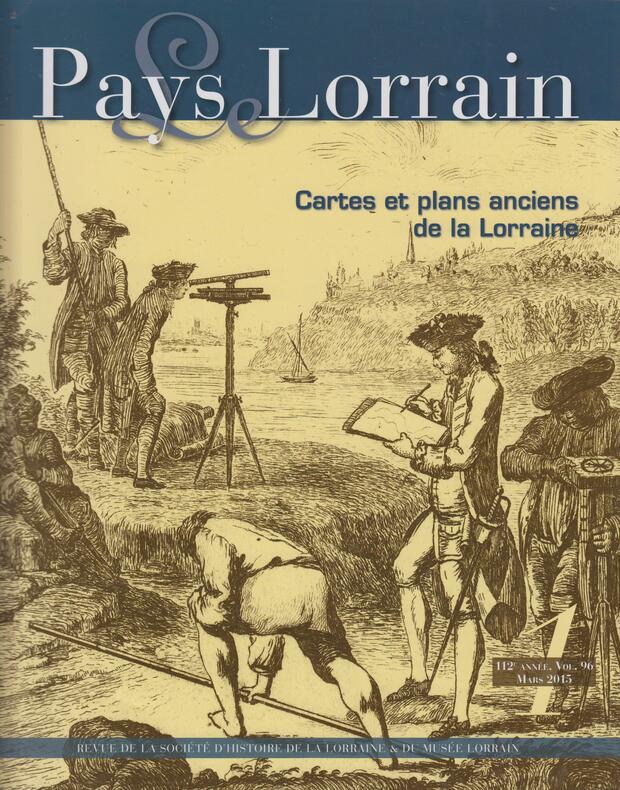
LE PAYS LORRAIN / Mars 2015 (112e année - volume 96).
CARTES ET PLANS ANCIENS DE LA LORRAINE.
Nancy : Société d'Archéologie Lorraine / Musée Historique Lorrain, 2015. Revue 27,5x22cm, couverture illustrée en noir, 103 pages illustrées en noir et couleur.
Bookseller reference : SPN-943
|
|
|
LEAKE W.R.M.
Gilkes and Dulwich 1885-1914. A Study of a Great Headmaster. REMARKABLY BRIGHT, CLEAN COPY
8vo., First Edition, with portrait frontispiece; blue cloth, upper board and backstrip blocked and lettered in gilt, a very good, bright, clean copy. VERY SCARCE IN THIS CONDITION.
|
|
|
Leake William Martin
Topographie Athens. Zweite Ausgabe. Uebersetzt von J.G. Baiterund H. Sauppe. Mit acht tafeln.
In 8° grande; VIII, 469, (3) pp. e 8 c. di tav. alcune più volte ripiegate. Legatura novecentesca in mezza-tela con piatti foderati con carta marmorizzata coeva. Qualche leggerissima fioritura ininfluente in alcune pagine, dovuta alla qualità della carta e presente in tutti gli esemplari ma nel complesso, esemplare in buone condizioni di conservazione. La più celebre opera dedicata ad Atene dal famoso antiquario, numismatico e diplomatico inglese, William Martin Leake (Londra, 14 gennaio 1777 - Brighton, 6 gennaio 1860). L'opera qui presentataè considerato, il primo tentativo di trattare in maniera scientifica lo studio topografico di una città per comprenderne le varie stratificazioni storiche ed i cambiamenti avvenuti duranti i secoli. La precisione e attinenza storica di questo studio lo fece ritenere il migliore sull'argomento eseguito, sotto diversi aspetti, per lunghissimo tempo. A lui si deve anche la mappatura delle coste dell'Albania e della Morea. "Nel 1807, in seguito allo scoppio della guerra tra Turchia e Inghilterra, fu fatto prigioniero a Salonicco; ma, ottenuta la sua liberazione nello stesso anno, fu inviato in missione diplomatica presso Alì Pascià di Ioannina, di cui conquistò la fiducia, e con cui rimase per più di un anno come rappresentante britannico". Good copy.

|
|
|
LEARMONTH Bob
The First Croydon Airport 1915-1928. BRIGHT, CLEAN COPY
8vo., First Edition, with photographs and maps in the text, small neat personal stamp on title; original pictorial wrappers, a very good, clean copy.

|
|
|
LEBECH, MOGENS.
Gamle Skibe, Gamle Huse - en bog fra Christianshavn.
Kbhvn., 1959. 4to. Orig. hshirtbd. 210 pp., rigt illustr., delvis i farve.
|
|
|
LEBECH, MOGENS.
Gamle Skibe, Gamle Huse - en bog fra Christianshavn.
Kbhvn., 1959. 4to. Orig. hshirtbd. 210 pp., rigt illustr., delvis i farve.
Bookseller reference : 23730
|
|
|
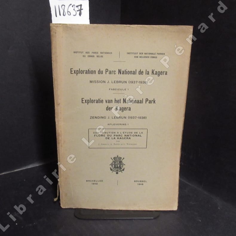
LEBRUN, J. - TATON, A. - TOUSSAINT, L.
Contribution à l'étude de la flore du parc national de la Kagera. Exploration du Parc National de la Kagera, Mission J. Lebrun (1937-1938), Fascicule 1. Exploratie van het National Park der Kagera, Zendig J. Lebrun (1937-1938), Aflevering 1.
1948 Institut des Parcs Nationaux du Congo Belge / Instituut der Nationale Parken van Belgisch Congo - 1948 - In-8, broché - 160 p. - Planches hors texte en N&B en fin d'ouvrage - Ouvrage non coupé (jamais lu)
Bookseller reference : 118637
|
|
|
Lechner, R
Innsbruck und Achen-See. Zone 16 Col. V. Maßstab 1 : 75 000. Topographische Detailkarten. Specialkarte von Österreich - Ungarn.
Wien, Lechner, 1893, Nachtrag 1909. 1 Bll., auf 8 Segmenten, coloriert, 38 x 51 cm OLeinen
Bookseller reference : 155297

|
|
|
Lechner, R
Sterzing und Franzensfeste. Zone 18 Col. V. Maßstab 1 : 75 000. Topographische Detailkarten. Specialkarte von Österreich - Ungarn.
Wien, Lechner, 1892, Nachtrag 1909. 1 Bll., auf 8 Segmenten, coloriert, 38 x 51 cm OLeinen
Bookseller reference : 155298

|
|
|
LECOINTRE, Georges - F. de LAPPARENT, Albert (Sous la direction de)
La Touraine. Tome IV. Actualités scientifiques et industrielles. 1027. Géologie régionale de la France.
1947 Editions Hermann & Cie, Paris - 1947 - In-4 broché - 250 pages - 49 figures dont 1 carte dépliante en N&B et rouge - 4 planches en N&B in fine - Feuillets non coupés (jamais lu)
Bookseller reference : 122799

|
|
|
LECONFIELD Lord
Sutton and Duncton Manors. NEAR FINE COPY IN DUSTWRAPPER
8vo., Sole Edition, on laid paper, with a plate, 2 sketch-maps in the text and 2 large folding maps; cloth, gilt back, a near fine copy in the dustwrapper. A companion volume to the author's 'Petworth Manor in the Seventeenth Century'

|
|
|
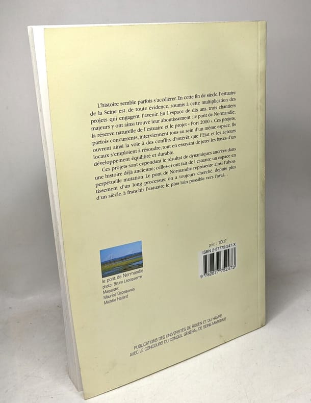
Lecoquierre Bruno
L'estuaire de la Seine: espace et territoire
PU ROUEN 2000 16x1 2x23 8cm. 2000. Broché.
Bookseller reference : 100131863 ISBN : 287775247
|
|
|
Lecotté (Roger)
Recherches sur les cultes populaires dans l'actuel Diocèse de Meaux (département de Seine-et-Marne).
Paris Mémoires de la Fédération folklorique d'Ile-de-France 1953 Un volume in-4 demi chagrin rouge, dos à nerfs, titre doré, couverture conservée, 383 pages. Dépigmentation de deux caissons au dos, bel exemplaire néanmoins.
Bookseller reference : 14454
|
|
|
LECOY F. ( Félix )
MÉTHODE SIMPLE ET FACILE POUR LEVER LES PLANS, suivie d'un traité du nivellement, d'un abrége des règles du lavis et des éléments de trigonométrie rectiligne
Paris Chez Duponcet, libraire 1813 in 8 (19,5x11,5) 1 volume reliure pleine basane havane granitée de l'époque, dos lisse orné, pièces de titre de maroquin rouge, XXIV et 116 pages [1], avec 12 planches dépliantes dont 9 aquarellées. Félix Lecoy. Exemplaire bien complet des 12 planches gravées, dont 9 très finement aquarellées à l'époque. Très bel exemplaire, très frais ( Photographies sur demande / We can send pictures of this book on simple request )
Bookseller reference : 44946
|
|
|
LEDOUX (Robert)
A L'Échelle Manuel du Topographe Amateur.
Dessin de A. Boekholt, P. Joubert et D. Ragonneau. Hors-texte gravés par l'Institut National de Géographie. 2 ème édition revue. Cahors, A. Coueslant, «Éclaireurs Unionistes de France», 1942. In-8 (21,7x14cm) broché, couverture illustré d'un paysage. 83pp.
Bookseller reference : WOC-1675

|
|
|
LEDOUX Robert
A L'ECHELLE manuel du topographe amateur
1935 plaquette in-octavo (booklet in-octavo), dos marron imprimé (brown spine printed), première de couverture verte imprimée et illustrée (green front cover printed and illustrated), quatrième de couverture muette (back cover without text), toutes tranches lisses (all smooth edges), page de faux-titre (half title page), illustrations : 47 figures explicatives in texte et hors-texte (illustrations : 47 explanatory pictures in text and full page engraving) - dessins de (drawings of) A. Boekholt - Pierre Joubert et (and) D. Ragonneau, 80 pages, 1935 à Courbevoie les Editions La Flamme 78 quai du Maréchal Joffre,
Bookseller reference : 15066
|
|
|
LEERBECH, HANS.
Forsøg til en Beskrivelse af Ringe Sogn.
Odense, 1826. 4to. Lidt senere velbevaret hldrbd. (8),130,(1) pp.
|
|
|
LEERBECH, HANS.
Forsøg til en Beskrivelse af Ringe Sogn.
Odense, 1826. 4to. Lidt senere velbevaret hldrbd. (8),130,(1) pp.
Bookseller reference : 7883
|
|
|
LEERBECH, HANS.
Forsøg til en Beskrivelse over Ringe Sogn.
Odense, 1826. 4to. Smukt privat hldrbd. i brun oaseged, bred ryg og hjørner(Axel Jensen). (8),130,(1) pp. Brunplettet.
|
|
|
LEERBECH, HANS.
Forsøg til en Beskrivelse over Ringe Sogn.
Odense, 1826. 4to. Smukt privat hldrbd. i brun oaseged, bred ryg og hjørner(Axel Jensen). (8),130,(1) pp. Brunplettet.
Bookseller reference : 14626
|
|
|
LEFERT Paul
Aide-mémoire d'anatomie topographique, pour la préparation du troisième examen.
Paris, Librairie Baillière et Fils, 1894. 10 x 18, 298 pp., cartonnage d'édition, bon état (nombreux soulignages au crayon et annotations).
Bookseller reference : 30361
|
|
|
LEFEVRE Leon
Notions élémentaires sur les erreurs dans les opérations topographiques
Bruxelles, De Boeck 1946 66pp., brochure originale, 21cm., bon état, A26795
Bookseller reference : A26795
|
|
|
LEFF Vera
The Story of Tower Hamlets. IN ORIGINAL WRAPPERS
8vo., First Edition, with photographs in the text; pictorial wrappers, wrappers lightly chafed edges else a good, clean copy. With numerous trade advertisements throughout.

|
|
|
LEFRANC, Georges:
Guide de la navigation de plaisange sur le Léman. Tome 1 & tome II.
Thono les Bains, Librairie Pellissier, 1926, in-8vo oblong, 104 p., avec 35 cartes, 24 vues, 13 plans + une planche (carte) dépl. du Léman / 282 p. ill.,, brochure originale illustrée.
Bookseller reference : 94057aaf
|
|
|
LEFÈVRE Léon
Notions élémentaires sur les erreurs dans les opérations topographiques
66pp.
|
|
|
LEGER-GORDON D. St.
The County Books. Devonshire. NEAR FINE COPY IN UNCLIPPED DUSTWRAPPER
8vo., First Edition, with frontispiece, 48 plates and large folding map; original series binding of decorative green cloth gilt, gilt back, a near fine copy in unclipped dustwrapper, the latter with minor loss (affecting lettering) at tail of backstrip. Published in Hale's seminal 'County Books' series. SCARCE IN THIS CONDITION.

|
|
|
LEGRIS (Louis).
LA NOUVELLE MECANIQUE AGRICOLE, ou l'art de rendre l'agriculture une fois plus productive avec moins de travaux de la part des hommes; suivi de la manière de faire mécaniqueemnt, par des moteurs fournis par la nature, le tracé des routes, des canaux de navigation, de dessèchemens et d'irrigations, le creusement des rivières, des carrières, des mines, des fortifications passagères et permanentes, etc., etc. Et d'un supplément à la mécanique agricole.Ouvrage contenant plus de deux cents inventions jusqu'alors inconnues.
Paris, Maurice, 1825, 1 demi basane, dos orné, tranches marbrées. in-8 de (4)-495 pp. + 2 grandes planches dépliantes de 102 figures ;
Bookseller reference : 15972
|
|
|
LEHMANN John
Holborn. An Historical Portrait of a London Borough. NEAR FINE COPY IN UNCLIPPED DUSTWRAPPER
8vo., First Edition, with plates and endpaper maps; blue cloth, gilt back, a near fine copy in unclipped dustwrapper.
|
|
|
LEIGH-ON-SEA
Leigh-on-Sea. A Town Guide. FINE COPY
8vo., First Edition, with coloured and monochrome illustrations, and double-page plan; pictorial wrappers, wire-stitched as issued, a fine copy. With numerous trade advertisements.

|
|
|
LEJOSNE Louis-Antoine (& AYMARD R., ed.)
Dictionnaire topographique du département des Hautes-Pyrénées
6 + xxii + 204pp. + 1 grande carte dépliante, dictionnaire rédigé en 1865 et révisé et annoté par R. Aymard, 24cm., brochure originale, bon état, G103437
|
|
|
LEJOSNE Louis-Antoine (& AYMARD R., ed.)
Dictionnaire topographique du département des Hautes-Pyrénées
Pau, 1992 6 + xxii + 204pp. + 1 grande carte dépliante, dictionnaire rédigé en 1865 et révisé et annoté par R. Aymard, 24cm., brochure originale, bon état, G103437
Bookseller reference : G103437
|
|
|
Lemper, Ernst Heinz
Adolf Traugott von Gersdorf (1744-1807). Naturforschung und soziale Reformen im Dienste der Humanität.
Berlin. VEB Deutscher Verlag der Wissenschaften, 1974. 415 Seiten 8° , Original Leinen mit Schutzumschlag ( Schutzumschlag mit geklebtem Einriss)
Bookseller reference : 12259

|
|
|
Lendenfeld, R. v
Der Tasman-Gletscher und seine Umrandung. [Hrsg.:] Behm, Ernst. [Mittheilungen [Mitteilungen] aus Justus Perthes' Geographischer Anstalt über wichtige neue Erforschungen auf dem Gesammtgebiete [Gesamtgebiete] der Geographie. Ergänzungsheft. Nr. 75].
Gotha, Justus Perthes 1884. 4°. 80 pp., 1 Tafel, 10 Textabbildungen, 2 mehrfarbige Karten in Imperial-Folio [So komplett]. Neuere Interimsbroschur. Vom Schnitt her etwas angestaubt.
Bookseller reference : 6045983
|
|
|
Lendenfeld, R. v
Forschungsreisen in den Australischen Alpen. [Hrsg.:] Supan, Alexander. [Mittheilungen [Mitteilungen] aus Justus Perthes' Geographischer Anstalt über wichtige neue Erforschungen auf dem Gesammtgebiete [Gesamtgebiete] der Geographie. Ergänzungsheft. Nr. 87].
Gotha, Justus Perthes 1887. 4°. 37 pp., 3 Karten auf 2 Tafeln [So komplett]. Neuere Interimsbroschur. Vom Schnitt her etwas angestaubt.
Bookseller reference : 6045994
|
|
|
LENOX-CONYNGHAM G.H.
Lavenham Church and Town. [Second Edition].
8vo., Second Edition, with 4 plates; original printed wrappers, wire-stitched as issued, uncut, a very good, bright, clean copy. First issued in 1927. Uncommon. Steward 6385.
|
|
|
Lentner, Friedrich, Ludwig Steub und Georg Mayr
Malerische Ansichten von Süd- und Nord-Tirol Nach der Natur gezeichnet von F[riedrich] Würthle, in Stahl gestochen von denselben u. Andern, nebst erklärenden Texten; begonnen von J[oseph Friedrich] Lentner, Ludwig Strub und Georg Mayr. Reprint der Ausgabe Salzburg, Baldi 1852
Tausch, Innsbruck, 1982. quer 42x30 cm, 2 Bl., 40 Blatt kolorierte Ansichten und 40 Blatt erläuternder Text, 2 Blatt Weinroter Originalleinenband mit originalgetreuer Gold- u. Blindprägung im Originalschuber. Folio 42 x 31cm
Bookseller reference : 289156

|
|
|
LENÆUS, KNUT NILSSON.
Delsboa illustrata, eller Delsbo socken i norra Helsingland, i sådan måtto ljusliga beskrefwen, at de förelagde fyra och fyratio frågor, dem framledne högwördige dom-probsten i Wäxiö, herr doctor Sven Bælter, då han år 1736 ännu war philosophiæ candid...
Stockholm, Nyströms & Stopes, 1764. 8vo. In a later half calf binding with gilt lettering and ornamentation to spine. Brownspottet throughout. (14), 256, (2) pp. + 1 folded map and numerous woodcuts in the text.
Bookseller reference : 61193
|
|
|
LEOMINSTER
The Priory Church, Leominster. A Brief Survey, Historical and Architectural. NEAR FINE COPY
8vo. First Edition with photographs (a number full-page) in the text and a full-page plan in red and black; original printed wrappers wire-stitched as issued photograph mounted on upper cover yapped edges a near fine copy. SCARCE

|
|
|
LEONARDO RICCI - MARINELLI
CENNI SULLA COSTRUZIONE E LA LETTURA DELLE CARTE TOPOGRAFICHE - GEOGRAFIA - IL NUOVO MONDO
In 4. cm 27,5x19. Pp. 28+(2)+VII+141+VII+234+256+39+(1). Raccolta di cinque opere di geografia raccolte insieme in un unico volume. La prima del 1924 è un manuale con alcuni cenni sulla costruzione e lettura delle carte topografiche e geografiche ed esecuzione degli schizzi di Leonardo Ricci.<BR>La seconda, la terza e la quarta del 1922 di geografia per il ginnasio di Marinelli e Ricci. Rispettivamente riguardano l'Italia, l'Europa e il nuovo mondo (quest'ultimo privo di frontespizio).<BR>L'ultima opera di Olinto Marinelli è un quadro politico statistico del mondo in particolare dell'Italia.<BR>Numerose illustrazioni (es. Porto di Camogli, Gran Assaly, Lago di Garda, Gran Sasso, Gennargentu, Mantova, Venezia, Cascata delle Marmore, Londra, Avila, Luneburgo, Amsterdam, TRansilvania, Ragusa, Berat, Atene ecc..), cartine (es. Torino, Milano, Venezia, Trieste, Bologna, La Spezia, Genova, Firenze, Livorno, Ancona, Roma, Napoli, Brindisi, Taranto, Messina, Palermo, Siracusa, Cagliari ecc..), e mappe <BR>In buone condizioni. Copertina in mezza tela in buone condizioni con usure e parti mancanti ai marginie dorso. Legatura in buone condizioni con qualche rottura. Pagine in buone condizioni con rare fioriture. Alcune usure marginali. Colelction of five works of geography collected together in a unique volume.<BR>The first one of1924 is a manual with some information about drawing and readings of maps by Leonardo Ricci. The second one, third one and fourth one of 1922 of geography for high school by Marinelli and Ricci. They relate Italy, Europe and the new World (this last one without title page).<BR>The last work of Olinto Marinelli is a statystical frame relating Italy in particular.<BR>Different illustrations (es. Porto di Camogli, Gran Assaly, Lago di Garda, Gran Sasso, Gennargentu, Mantova, Venezia, Cascata delle Marmore, Londra, Avila, Luneburgo, Amsterdam, TRansilvania, Ragusa, Berat, Atene ecc..), maps of cities (es. Torino, Milano, Venezia, Trieste, Bologna, La Spezia, Genova, Firenze, Livorno, Ancona, Roma, Napoli, Brindisi, Taranto, Messina, Palermo, Siracusa, Cagliari ecc..), and maps In good conditions. Half cloth cover in good general conditions slightly worn in the edge and spine. Binding in poor conditions with cracks. Pages in good conditions with occasional foxings. Some tears in the edges.

|
|
|
Leone Antonio
Ambiente e pianificazione. Uso del suolo e processi di sostenibilità
br. Il saggio esplora i processi per capire specificità e diversità dell'ambiente fisico, la struttura di base degli habitat di piante, animali e uomini. Ne scaturiscono le analisi dei possibili impatti dell'uso del suolo, con lo scopo di trovare gli strumenti per prevenire gli squilibri, piuttosto che curarli a posteriori, che è lo scopo fondamentale della pianificazione sostenibile. Per quest'ultima la questione del paesaggio, ormai liberata dai canoni esclusivamente estetico-percettivi, è prioritaria. Il primo capitolo è dedicato a questo tema, strategico sia per la dimensione regionale e territoriale dei piani paesaggistici, sia perché il paesaggio è prodotto dall'interazione fra natura e cultura e il fulcro della sostenibilità non può che essere qui. Seguono due capitoli "di servizio", dedicati al quadro normativo italiano ed alla lettura del territorio, quindi, nei successivi tre ("Aria", "Suolo" e "Acqua"), si analizzano i processi dell'ambiente fisico in termini di correlazione fra i suoi caratteri intrinseci e gli impatti generati dall'azione antropica, ovvero l'uso del suolo. L'impostazione dell'analisi deriva da una riflessione sulla massima di Alfred Korkybski: «la mappa non è il territorio»; essa trae origine dall'astrazione, che è la caratteristica tipica di questo modo di conoscere. La mappa però è statica, è una fotografia della realtà, che invece è dinamica e complessa, motivo per cui è utile il modello di simulazione dei processi; anch'esso "non è il territorio", ma ha il pregio di aggiungere alla mappa la valutazione preventiva di scenari e l'impatto ambientale. Questa nuova edizione del testo illustra tali processi, con una focalizzazione più netta sull'uso del suolo, per cui, quando necessario, propone i cosiddetti modelli di simulazione "manageriali", orientati a definire scenari, anticipando e chiarendo al pianificatore le possibili conseguenze delle decisioni.

|
|
|
LEPAGE Henri
Dictionnaire topographique du département de la Meurthe.
Dictionnaire topographique du département de la Meurthe. Rédigé sous les auspices de la société d’archéologie lorraine par Henri LEPAGE In 4 broché, titre, XXVII 213 pages, non coupé, texte sur 2 colonnes sur vergé. Paris imprimerie impériale MDCCCLXII. Dos factice. Un petit manque au deuxième plat de couverture.
Bookseller reference : 12847

|
|
|
LEPAGE Henri.
DICTIONNAIRE TOPOGRAPHIQUE DU DEPARTEMENT DE LA MEURTHE, comprenant les noms de lieu anciens et modernes, rédigé sous les auspices de la Société d'Archéologie Lorraine.
Paris, Imprimerie Impériale, M DCCC LXII, reliure demi-basane rouge, dos à 5 nerfs, titre doré, 23x28cm, XXVII+213 pages, impression sur 2 colonnes, bon état (photo par mail sur demande).
Bookseller reference : 1757
|
|
|
LESAGE Christiane & THIEBAUT Jacques [DE CROY]
Albums de Croÿ. Tome VII (7): Comté de Hainaut IV : Prévôté de Valenciennes et châtellenie de Bouchain
Bruxelles, Crédit Communal de Belgique 1987 275pp., avec 109 illustrations pleine-page en couleurs, reliure cart. d'éditeur, jaquette illustrée, 34cm., bel état, poids: 2.5kg., B119085
Bookseller reference : B119085
|
|
|
LESAGE Christiane [DE CROY]
Albums de Croÿ, Tomes XII-XIII: Chatellenies de Lille, Douai, Orchies. Ie partie: Généralités, abbayes, villes et villages, IIe partie: villages [2 volumes]
Bruxelles, Crédit Communal de Belgique 1985-1986 Tomes 12-13, 232 + 241pp., avec 194 planches en couleurs pleine-page, reliures cart. d'éditeur, jaquettes, 34cm., très bon état, poids: 4.5 kg., B119081
Bookseller reference : B119081
|
|
|
LETHABY W.R.
London before the Conquest. [First and Sole Edition]. LONDON BETWEEN ROMANS AND NORMANS
8vo., First Edition, with frontispiece map, very numerous illustrations (3 full-page) and 2 full-page maps in the text, free endpapers mildly browned; red buckram gilt, gilt back, uncut, backstrip lightly sunned as often else a very good, bright, fresh, clean copy. With 2pp publisher's advertisement bound in at end. The first authoritative treatment of the topography of the capital between the Romans and the Conquest.

|
|
|
LETHBRIDGE Richard
Tiverton Staghounds. [Second Edition]. SIGNED BY THE AUTHOR
8vo., Second Edition, with 32 coloured plates on 16 and very numerous monochrome photographs and facsimiles in the text; original ivory pictorial cloth, upper board and backstrip blocked and lettered in brown, cream endpapers, a near fine copy in unclipped dustwrapper. SIGNED BY THE AUTHOR ON HALF-TITLE. Published two months after the first edition. Extremely scarce

|
|
|
Lettau Heinz H., Davidson Ben.
EXPLORING THE ATMOSPHERE'S FIRST MILE. Volume I: Instumentation and data evalutation - Volume II: Site description and data tabulation.
(Codice AV/1073) Set of 2 volumes in 8° (235x165 mm) XIV-578 pp. First edition. Illustrated with many figures and photographs. Editorial cloth, gilted titles, dust jackets. A fine copy. ~~~ SPEDIZIONE IN ITALIA SEMPRE TRACCIATA

|
|
|
Leuckfeld, Johann Georg
Antiquitates Halberstadenses, Oder Historische Beschreibung des vormahligen Bischoffthums Halberstadt, und deren darinnen gelebten Bischöffe... (Teil 1: Alles Erschienene): Von Anno 814 an bis Anno 1122 nach Christi Gebuhrt. Wolfenbüttel, Freytag, 1714. Gestochenes Frontispiz, Titel in Rot und Schwarz, 6 n.n. Bll., 715 SS., 18 n.n. Bll.
o.J. 4°, brauner Kalbslederband der Zeit mit goldgepr. Rückenschild und reicher Rückenvergoldung. Die Vergoldung etwas verblichen. Unteres Kapital fehlend, linke obere Ecke des Vorderdeckels mit kl. Wurmspur.
Bookseller reference : 22317
|
|
|
Leuckfeld, Johann Georg
Antiquitates Poeldenses. Oder Historische Beschreibung des vormahligen Stiffts Poelde/ Præmonstratenser Ordens/: Worinnen von dieses Closters Nahmen/ Stifftungs-Zeit/ Landes-Gegend/... wie auch unterschiedenen bey solchem Closter ehemahls gelebten/ ... Gräfl. und Edlen Geschlechtern/ insonderheit aber von der noch florirenden Hohen/ Adelichen Wurmischen Familie außführlich gehandelt wird; Welchen auch noch unterschiedene alte bisher unedirte Fundations-Brieffe/ Käyserl. Privilegia und Diplomata von denen Clöstern Marienrode/ Jlsenburg/ Neuenstadt/ Bischoffthum Würtzburg/ und Goslarischen Dom-Kirche beygefüget / ... zusammen getragen/ und mit dienlichen Anmerckungen erläutert.
Wolffenbüttel, Gottfried Freytag, 1707. Titel in Rot-Schwarz, Kupferfrontispiz, [2] Bl., 156 S., [5] gefalt. Genealogie-Taf.; S.[205]-273 [i.e. 311] S., [4] Bl. (Addenda ad Antiquates Poeldenses...). Mit Holzschnitt-Schlußvignette. Kl.-4to (21 cm). Gehefteter Buchblock im Interimsumschlag (dieser schadhaft).
Bookseller reference : 97194

|
|
|
 Receive by email
 Download as PDF document
 RSS feed


