|
Japan
Landkarte im Maßstab 1:3,168.000.
Ldn., Edward Stanford o. J. (um 1890). Flächenkol., lithogr. Landkarte in 20 Teile zerschnitt. u. auf Leinen aufgezogen, in Leporellofaltung, Ln.-Mappe m. aufkasch. Deckelbildchen der Fa. George Philip & Son, London, eine Teilkartenrückseite u. Innendeckel m. gefedertem Vorsatzpapier beklebt, am Einbd. geringe Gebrauchsspuren, am re. Kartenrand Klebeet. d. Fa. George Philip & Son, Map, Chart, and Geographical Depot London, Karte in sehr gutem Zustand.
Referenz des Buchhändlers : KART0060

|
|
|
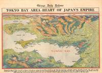
JAPAN TOKYO WORLD WAR II MAP GFROERER CURT ARTIST.
Tokyo Bay Area - Heart of Japan's Empire.
Chicago.: Chicago Daily Tribune. 28 July1945. Colour bird's eye view map 22.4 x 39.3 cms on a newspaper leaf trimmed to a half sheet 29.8 x 41.6 cms including caption slight toning at an old central fold the map in very good condition. <br>Unrelated black and white photographic illustrations on the verso "Pre-flight Trainers used in Chicago to give ground instruction to would-be pilots" and "New rekindled Montauk Light Long Island N.Y." Map published in the Chicago Daily Tribune days before the bombing of Hiroshima on August 61945. <br>"Perspective map of Tokyo bay and contiguous land and sea areas showing Tokyo Yokohama the Yokosuka naval base industrial sections and other features .In this map north is at the right instead of at the top - an expedient adopted to show all of the bay as large as possible in half page space." caption . Chicago Daily Tribune. unknown
Referenz des Buchhändlers : 209335
|
|
|
Japan, Travel & Maps
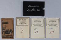
Pre-War Japan Travel Photo Album 1930s
1930. Japan Travel & Maps Japan photo album at the wake of economic expansion during the 1930s taken by elite Western tourists.Album measures 8.5" x 12" and images measure 5" x 7". The album begins with portraits of a well-dressed white American family —in tailored Western clothing posing in front of Buddhist temples and residential gates. These early photos indicate the album was compiled by or for a member of this family most likely a man pictured later in a sweater and bowtie suggesting they were wealthy expatriates diplomatic guests or elite tourists. The bulk of the album captures a wide array of architectural religious and theatrical scenes: richly ornamented temple facades in Nikko and Akashi; the dramatic cascades of Takao; and a Kabuki-style revue performance at Osaka’s Shochiku-za theatre complete with dancers in flamboyant headdresses and stage makeup. The album also includes a rare image labeled “Korea†depicting seated women in hanbok taken during Japan’s occupation of Korea 1910–1945. This image places the album firmly in the context of Japan’s imperial expansion and tourist circuits as Korea was increasingly marketed as an extension of Japanese heritage during the 1930s.Comprising of 22 silver gelatin prints this album captures an elite transnational family’s travels across imperial Japan during a decade of political expansion militarism and heightened nationalist aesthetics. The photographs are mounted one per page on thick black paper with neat white ink captions including "Nikko" "Kyoto" "Shochiku-za" "Koya San" "Akashi" "Takao" and "Korea." Album bound in textured beige cloth boards with four vertical red stripes and a braided cord tie. Three of the photos are studio portraits of the Western family while the other 19 are shown of Japan.<br /> <br /> In the 1930s Japan was undergoing a period of growing authoritarianism territorial expansion into Manchuria beginning with the 1931 Mukden Incident and cultural consolidation under the banner of the Emperor and the “Japanese spirit†Yamato-damashii. At the same time the state promoted a carefully curated image abroad presenting Japan as a land of picturesque tradition and modern efficiency. Wealthy Westerners—often from diplomatic missionary academic or industrial backgrounds—traveled through Japan during this era drawn to its “exotic†temples vibrant urban centers and reliable infrastructure. Culturally this period marked a dual movement: while Japan embraced modern technologies and urban sophistication it simultaneously institutionalized a revival of “pure†Japanese aesthetics from Shinto shrines and Noh drama to kabuki theater and traditional crafts all folded into an ideology of cultural nationalism. The nation’s growing empire—encompassing Korea Taiwan and parts of China—was increasingly presented to foreigners as an extension of this national identity. Tourism was filtered through a lens of nostalgic tradition often obscuring the violence of imperial rule. This album reflects those intersecting colonial and touristic gazes balancing reverence for the beauty of Japanese religious architecture with the spectacle of staged performance and a foreign fascination with cultural otherness. Photographs are of excellent clarity and overall great condition. A vivid nuanced visual record of elite Western travel in imperial Japan on the cusp of global conflict reflecting transnational interactions under the shadow of rising fascism and empire. unknown
Referenz des Buchhändlers : 22302
|
|
|
Japanese Hand Coloured Wood Block Printing; Maps and Atlases; Tokyo Map Hyoshiya Ichirobe
A WOODBLOCK HAND-COLOURED MAP OF TOKYO; JAPAN EIRI EDO OEZU Illustrated Edo
Edo Tokyo: Hyoshiya Ichirobe Hayashi-shi Yoshinaga First month 1684 But Third month 1680. A large woodcut map of Edo Tokyo with fine handcolouring on joined and folded paper. The map is breathtaking in its detail and features many paintings of important landmarks temples bridges and people who are often pictured working or fishing from boats on the waterways running through Tokyo. A stunning and very rare woodblock map beautifully and unusually handcoloured. Roads blocks buildings open areas canals and waterways are all vividly laid out on this huge and most impressive map. 123.5 by 149.5 cm. folded within paper covers folds to 28 by 18 cm now preserved in a fine clamshell box. A remarkably well preserved and very rare item with some light rubbing due to age and as to be expected. A bit of old worming or light soiling and occasional small repairs but in all quite astonishing in its quality and beautifully preserved with bright and vivid colour and detail. AN EXTRAORDINARY ITEM REMARKABLE FOR BOTH ITS CARTOGRAPHIC DETAIL AND ITS ARTISTIC BEAUTY. The wood block printing shows land tenures of Daimyo and Hatamoto. It also shows temples and shrines includes a distance chart and descriptive listing of Daimyo showing crests and halberds. There is also a inset of the eastern portion of Edo. Hyoshiya Ichirobe (Hayashi-shi Yoshinaga) unknown
Referenz des Buchhändlers : 24285

|
|
|
Jason, David with Edworthy, Niall
David Jason - In His Element
No marks or inscriptions. No creasing to covers or to spine. A lovely clean crisp very tight copy with bright unmarked boards and no bumping to corners. Dust jacket not price clipped or torn or creased. 160pp. David Jason takes the reader to some of the most exotic locations on the planet as he indulges in his passion for diving.

|
|
|
JAVA MOTOR CLUB THREE FOLDING LITHOGRAPH MAPS OF JAVA.
Automobielkaart van Java en Madoera Samengesteld en Uitgegeven Door de Koninklijke Vereeniging.
Semarang.: Hoofdkantoor. Circa1935. 3 folding colour lithographed maps on linen in a cloth covered slipcase lettered in white on the upper cover. Scale 1:500000. Each map has been signed and has been numbered 1 to 3 by a prior owner on the reverse of the map. Sheets measure 55.5 x 83.4cm; 56 x 90cm and 56 x 82.3cm. The first map is a little stained on the reverse but the stains are not visible on the map itself. Very good copies in like slipcase. TOGETHER WITH Afstands Tabellen 1928 a separate 62pp booklet accompanies the folder of maps spine repaired with washi tissue. . Hoofdkantoor. hardcover
Referenz des Buchhändlers : 219096
|
|
|
JAÏS Pierre et LAHANA Henri
"Bridge simple et moderne; enfin l'espéranto du bridge : la méthode de la longue d'abord."
Paris, René Julliard, 1970. 14 x 21, 277 pp., cartonnage d'édition + jaquette, bon état.
Referenz des Buchhändlers : 34019
|
|
|
JAÏS Pierre et LEBEL Michel
La majeure cinquième, la nouvelle bible du bridge. Collection les bases du bridge moderne.
Editions du Rocher, 1976. 13 x 20, 409 pp., très nombreux exemples, broché, bon état.
Referenz des Buchhändlers : 21215
|
|
|
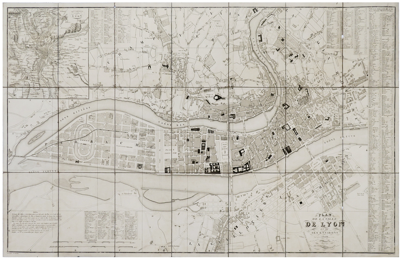
JEAN (Pierre).
[LYON] Plan de la ville de Lyon et de ses environs.
Paris, Jean, 1840. En 21 sections montées sur toile et pliées, formant un plan de 582 x 905 mm ; étiquette au dos avec titre manuscrit.
Referenz des Buchhändlers : LBW-6111
|
|
|
Jean-Pierre Seguin et Cécile de Jandin (Catalogue rédigé par) ; Julien Cain et Jean Adhémar (introduction de)
Cinq siècles de cartes à jouer en France. Bibliothèque nationale Galerie Mansart Septembre- Octobre 1963
Paris, bulletin du Vieux Papier / Fascicule 205 , 1963 0 un fascicule in-4°, 93 pp., couverture illustrée. (pages légèrement cornées). 423 n° décrits. Quelques illustrations en noir. Complet du feuillet d'errata. Peu courant.
Referenz des Buchhändlers : 024951
|
|
|
Jean-René Vernes
Le Bridge
Hatier 1982 1982. L'ouvrage 'Le Bridge' de Jean-René Vernes et Henri Samouiloff publié chez Hatier en 1982 présente une méthode d'évaluation des mains au bridge basée sur une étude statistique rigoureuse des donnes de compétition. Ce livre technique s'adresse aux bridgeurs cherchant à appliquer une approche systématique et théorique au jeu
Referenz des Buchhändlers : 500318405

|
|
|
Jean-Marie LHOTE
Les TAROTS
Un ouvrage de 89 pages, format 200 x 295 mm, illustré, relié cartonnage couleurs, publié en 1978, Editions Atlas, bon état
Referenz des Buchhändlers : LFA01368
|
|
|
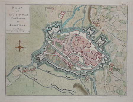
JEFFERYS (Thomas);
[ABBEVILLE] Plan of the city and fortifications of Abbeville.
London 1774 187 x 251 mm.
Referenz des Buchhändlers : LBW03d46
|
|
|
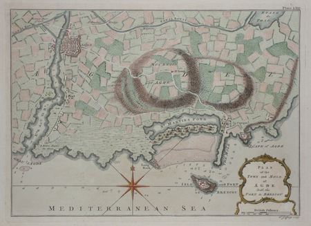
JEFFERYS (Thomas);
[AGDE] Plan of the town and mole of Agde with the fort de Brescou.
London 1774 197 x 276 mm.
Referenz des Buchhändlers : LBW03d43
|
|
|
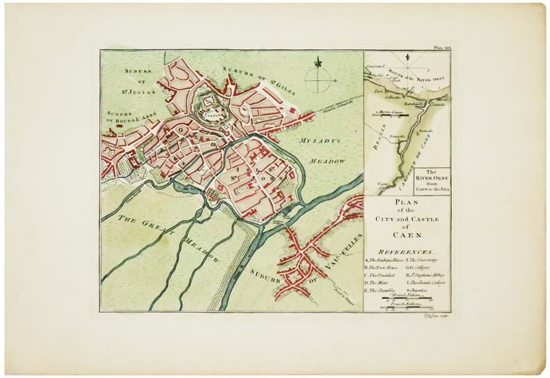
JEFFERYS (Thomas).
[CAEN] Plan of the city and castle of Caen.
[London, 1774]. 187 x 251 mm.
Referenz des Buchhändlers : LBW03d3d
|
|
|
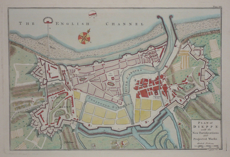
JEFFERYS (Thomas);
[DIEPPE] Plan of Dieppe with the new fortifications and projected works.
London 1774 209 x 312 mm.
Referenz des Buchhändlers : LBW03d47
|
|
|
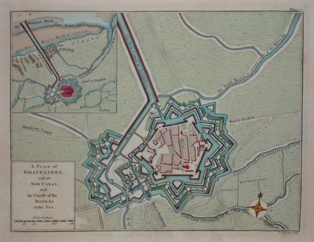
JEFFERYS (Thomas);
[GRAVELINES] A plan of Gravelines, with the new canal and the course of the river Aa to the sea.
London 1774 189 x 250 mm.
Referenz des Buchhändlers : LBW03d42
|
|
|
JEFFERYS (Thomas).
[LA CIOTAT] Plan of the town & harbour of La Ciotat.
[Londres, Thomas Jefferys, 1761]. 188 x 245 mm.
Referenz des Buchhändlers : LBW-8976

|
|
|
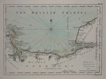
JEFFERYS (Thomas);
[NORMANDIE] 5th chart of the coast of France, from Fécamp to Cape Barfleur.
London 1774 180 x 248 mm.
Referenz des Buchhändlers : LBW03d48
|
|
|
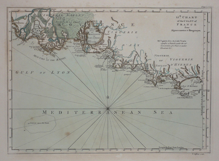
JEFFERYS (Thomas).
[PROVENCE] 15th chart of the coast of France from Aigues Mortes to Brégançon.
London, 1774. 180 x 248 mm.
Referenz des Buchhändlers : LBW03d44
|
|
|
Jefford, Andrew
Peat Smoke and Spirit : A Portrait of Islay and Its Whiskies
No marks or inscriptions. A very clean very tight copy with unmarked black cloth boards and no bumping to corners. Dust jacket not price clipped or marked or torn or creased with minor traces of storage. 406pp. History of the Scottish Isle of Islay and its whisky. The Island is home to seven of the world's most widely admired malt whisky distilleries on its shores and this study provides a most detailed analysis of Scotch malt whisky production. Maps on end papers.

|
|
|
Jenichen Balthasar (attivo dal 1560, morto nel 1599)
Roma
La rarissima veduta aerea di Roma di Balthasar Jenichen, pubblicata a Norimberga. La veduta di Jenichen deriva a sua volta da una xilografia della Cosmographia di Sebastian Münster (Basilea, 1550), che raffigura Roma così com'era intorno al 1490 (Per la veduta di Münster si veda A. Frutaz, Le piante di Roma, XCVIII)."Orientata con nord in basso. A proiezione obliqua; veduta prospettica. È una ripetizione del panorama comparso la prima volta col Bergomensis (1490) e, con lievi modificazioni, ripetuto poi nello Schedel, nel Munster e in altre edizioni tutte inspirate al panorama, detto di Mantova, e che rappresenta Roma sotto il Pontificato di Alessandro VI. Forse lo Jenicken ricalca un vecchio rame senza mai aver visto Roma, sicché non riesce ad interpretare la linea della cupola del Pantheon, colloca l'Aventino presso la Porta del Popolo e qua e là dissemina altri errori topografici. L'assenza del Colosseo ricollega la presente pianta più direttamente al Munster" (cfr. Scaccia Scarafoni, p. 74)."In alto a sinistra legenda con lettere di rimando in veduta (A-Z). È noto un solo altro esemplare con iscrizioni in caratteri gotici conservato al Paul Getty Museum ed un altro con iscrizioni in caratteri romani conservato presso la BVE. Si tratta pertanto di una pianta di estrema rarità e peraltro graficamente assai raffinata" (cfr. Marigliani p. 121, che erroneamente raffigura e attribuisce la copia con caratteri gotici allo Jenichen).Il lettering del nostro esemplare è in latino, mentre esiste una copia con caratteri gotici, di dimensioni ridotte. Un esempio (ex collezione Pecci-Blunt) si trova al Getty Museum, un altro è pubblicato su Marigliani, altro ancora è descritto da Scaccia Scarafoni alla Biblioteca Nazionale di Roma.La veduta dello Jenichen è sconosciuta a Frutaz, mentre Hollstein ne descrive solo 2 esemplari nelle collezioni dei gabinetti delle stampe di Berlino e Monaco. Scaccia Scarafoni descrive l'esemplare presso la Biblioteca Nazionale di Roma; Jenichen è stato il principale editore tedesco di carte topografiche. Insieme al connazionale Matthias Zündt si interessarono particolarmente alle cosiddette carte d'occasione - nate per documentare avvenimenti - e ne produssero diverse sulla scia e nella tradizione di quelle dei loro omologhi editori italiani. Data la loro natura effimera, sono tutte rare o introvabili.La veduta di Roma, priva di data, può essere ricondotta la periodo 1562-1590 in base alle informazioni sul periodo di attività dell'artista. Una datazione intorno al 1570 ci sembra più compatibile con alcuni dei lavori topografici - datati - dell'artista.Acquaforte e bulino, impressa su carta vergata coeva priva di filigrana, con margini, in perfetto stato di conservazione. Rarissima.BibliografiaScaccia Scarafoni, Le Piante di Roma, pp. 74-75, n. 129; Marigliani, Le piante di Roma nelle collezioni private, p. 121, n. 17; Hollstein XL B, p. 54, n. 150; G.K. Nagler, Lexicon, VI, p. 439, n. 2; Andresen II, Nr. 279; Passavant IV, p. 429, n. 27; Le Blanc, II, p. 429, n. 27. The very rare Balthasar Jenichen's etched bird's-eye view of Rome, published in Nuremberg. Jenichen's view in turn derived from a woodcut in Sebastian Münster's Cosmographia (Basel, 1550), which depicts Rome as it was about 1490 (For Münster's view, see A. Frutaz, Le piante di Roma, XCVIII).Münster's table with lettered names keyed to buildings and monuments on the view has been shifted from the foot to the upper left-hand corner in Jenichen and the present view. In its place at foot are eight quatrains of German verse on the rulers of Rome, the last line of which reads: Das spricht Balthasar Jenichen. Lettering in the present view is Latin, while there is a copy with Gothic lettering, reduced in size. One example (ex Pecci-Blunt collection's) is at the Getty Museum, another one is published in Marigliani - who erroneously attributes the copy with Gothic characters to Jenichen. Unknown by Frutaz; Hollstein describes only 2 example of this very rare work. Scaccia Scarafoni listed the further example at the Biblioteca Nazionale di Roma (that own also the copy with Gothic text).Jenichen was the leading German publisher of news-sheet maps. Jenichen and compatriot Matthias Zündt took particular interest in the conflict and produced views and maps of it that equaled and surpassed those of their Italian counterparts. Given their ephemeral nature, all are rare and desirable.The view of Rome, undated, can be traced back to the period 1562-1590 according to the artist's period of activity. A dating around 1570 seems to us to be more compatible with some of the artist's topographical and dated works.Etching and engraving, printed on contemporary laid paper, with margins, perfect condition.LiteratureScaccia Scarafoni, Le Piante di Roma, pp. 74-75, n. 129; Marigliani, Le piante di Roma nelle collezioni private, p. 121, n. 17; Hollstein XL B, p. 54, n. 150; G.K. Nagler, Lexicon, VI, p. 439, n. 2; Andresen II, Nr. 279; Passavant IV, p. 429, n. 27; Le Blanc, II, p. 429, n. 27.

|
|
|
Jenkinson, Michael; illustrated with photographs by Karl Kernberger, and maps
WILD RIVERS OF NORTH AMERICA
New York NY: E. P. Dutton & Company. G/G. 1973. First Edition. Cloth. Descriptions of some 115 wilderness waterways with indepth biographies of eight wild rivers and a voyagers' route. Seven appendices containing a select bibliography on river running; sources and information by states and provinces; conservation societies and whitewater organizations and boat builders and distributors. . 8vo. 413pp. Corner gently bumped rear hinge slightly shaken edge stains; dj frayed and torn . E. P. Dutton & Company hardcover
Referenz des Buchhändlers : BOOKS238999 ISBN : 0876900996 9780876900994

|
|
|
JERUSALEMS TEMPEL -
Jerusalems tempel Såsom thet syntes öster uth Medh alla sine Föreårdar eller Chorer, efter Ben. Ariae Montani Afritning.
(Stockholm, 1703). (33 x 42 cm.). Kobberstukket kort over Tempelgården i perspektiv. En ganske lille reparation nederste i midterfolden. I passpartou.
Referenz des Buchhändlers : 53195
|
|
|
JERUSALEMS TEMPEL -
Jerusalems tempel Såsom thet syntes öster uth Medh alla sine Föreårdar eller Chorer, efter Ben. Ariae Montani Afritning.
(Stockholm, 1703). (33 x 42 cm.). Kobberstukket kort over Tempelgården i perspektiv. En ganske lille reparation nederste i midterfolden. I passpartou.
|
|
|
JESSUP Frank W.
A History of Kent. with Maps and Pictures. BRIGHT, CLEAN COPY IN UNCLIPPED DUSTWRAPPER
8vo., First Edition, with 30 plates on 16 and 15 maps in the text; green cloth, gilt back, a very good, bright, clean copy in unclipped dustwrapper, the latter lightly frayed at extremities. Bennett p.184.

|
|
|
Jeu des Poètes
S.l. Delachaux et Niestlé s.d. [ca 1922] 80 cartes (11,5 x 7, 4 cm) présentées dans une boîte en carton avec étiquette illustrée au couvercle et règle du jeu contrecollée à l'intérieur
Referenz des Buchhändlers : 39844

|
|
|
JEU DE CARTES
Déclaration du Roy, donnée à Versailles au mois de mars 1703, portant que le droit de dix-huit deniers, ordonné être établi sur chacun ieu de cartes ou tarots, sera réduit et modéré à douze deniers, à commencer au mois d'avril prochain
Grenoble Alexandre Giroud 1703 in-4 dérelié
Referenz des Buchhändlers : 36185
|
|
|
JEUX - CARTES] WOESTYN Eugène
Le Livre des Amusements de la veillée contenant Les Tours de Cartes, Les Propriétés mystérieuses des nombres, les tours de physique, les problèmes amusants, etc., etc
Paris Ch. Ploche 1852 petit in-8 broché, couverture muette papier bleu moderne, rousseurs
Referenz des Buchhändlers : 39858
|
|
|
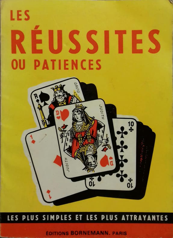
JEUX DE CARTES
Les réussites ou patiences.
Couverture rigide. Broché. 48 pages.
Referenz des Buchhändlers : 140082
|
|
|
JEUX DE CARTES
Règle du je de Piquet - Piquet ordinaire - Piquet à écrire - Piquet normand - Piquet voleur - Lois et conventions.
Paris, Delarue, sd (v. 1890) ; in-12, broché, couverture jaune illustrée. 36 pp.Bel exemplaire.
Referenz des Buchhändlers : 35503465
|
|
|
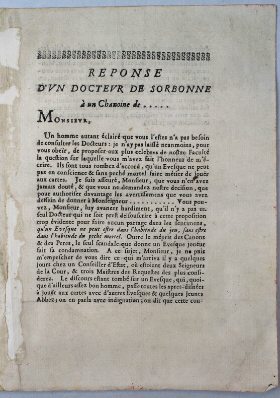
JEUX DE CARTES
Réponse d'un docteur de Sorbonnne à un chanoine de ...
(vers 1700).
Referenz des Buchhändlers : 18195
|
|
|
Jeux de societe & de Cartes, Editions
Le Baccalauréat - Le Jeu ! - Carnet de grilles à remplir avec vos meilleurs thèmes !: Bloc de 100 feuilles quadrillées vierges pour jouer au jeu le plus simple et amusant ! Jusqu'à 10 thèmes à insérer
Independently published 2020. Paperback. New. 100 pages. French language. 11.69x8.27x0.23 inches. Independently published paperback
Referenz des Buchhändlers : 2-165825015X ISBN : 165825015X 9781658250153
|
|
|
Jeux de societe & de Cartes Editions
Le Baccalauréat - Le Jeu ! - Carnet de grilles AVEC THEMES !: Bloc note de 100 feuilles de score pour jouer au jeu le plus simple et amusant ! De 5 à 99 ans en famille ou entre amis !
Independently published 2020. Paperback. New. 100 pages. French language. 11.69x8.27x0.23 inches. Independently published paperback
Referenz des Buchhändlers : 2-1658563115 ISBN : 1658563115 9781658563116
|
|
|
Jeux de societe & de Cartes, Editions
On se fait un TAROT ou quoi : Carnet de 100 grilles de score pour jeu de table / Tarot
Independently published 2020. Paperback. New. 100 pages. French language. 9.00x6.00x0.23 inches. Independently published paperback
Referenz des Buchhändlers : 2-165869029X ISBN : 165869029X 9781658690294
|
|
|
Jim Perry, Blank Endpaper FORMER OWNER STAMP, Illustrated By Photos Maps b/w
Stars Beyond The a Biographical Graveside Guide cemeteryS of Theda Bara Humphrey Bogart Bob Crane Marion Davies Sharon Tate Rudolph Valentino Peter Lorre Marilyn Monroe Bela Lugosi Errol Flynn Walt Disney Zazu Pitts Rosalind Russell ETC
Manhattan Beach CA Self-Published J. E. Perry 1978. Oblong Pictorial Paperback in B/W light creases Cover 1978 1st Edition Interior nice tight UNDERLINing Thruout VG/Good SOFTCOVER few notes in ink couple dog eared pgs . First Edition. Soft Cover. Manhattan Beach, CA Self-Published J. E. Perry paperback
Referenz des Buchhändlers : 23100
|
|
|
Jo Sturges and Denise Laing (editors)
The Pub Guide 2004
No marks or inscriptions. No creasing to covers or to spine. A very clean very tight copy with bright unmarked boards, minor traces of storage to front cover and no bumping to corners. 704pp. The state of play with pubs which were open in 2004.

|
|
|
JOANNE Paul
DAUPHINE ET SAVOIE 1883
1883 cart. éd. toil. verte in-12, 5 cartes, 2 plans, 3 panoramas, 462 p., 1883 hachette éd.,
Referenz des Buchhändlers : 751
|
|
|
JOANNE Adolphe
FRANCE NORMANDIE
1886 cart. toil. éd. in-8, 7 cartes repliées / onglet et 4 plans, 580 p., 1886 hachete éd.,
Referenz des Buchhändlers : 717
|
|
|
JOANNE (Adolphe)
Géographie du département de l'Ariège
Paris, Librairie Hachette, 1896, 66pp. in-12, rel. carto. édit, dos toilé bleu, ill. h.t 12 grav. et une carte coloriée h.t dépl.
Referenz des Buchhändlers : 3794
|
|
|
JOANNE (Adolphe)
Géographie du Lot
Paris, Librairie Hachette, 1879, 58 pp. in-12, rel. carto. édit, dos toilé bleu, ill. h.t 8 grav. et une carte coloriée h.t dépl.
Referenz des Buchhändlers : 3796
|
|
|
JOANNE (Adolphe)
Géographie de La Somme
Paris, Librairie Hachette, 1903, 68 pp. in-12, rel. carto. édit, dos toilé bleu, ill. h.t 11 grav. et une carte coloriée h.t dépl.
Referenz des Buchhändlers : 3797
|
|
|
JOANNE (Adolphe)
Géographie du Loiret
Paris, Librairie Hachette, 1903, 68 pp. in-12, rel. carto. édit, dos toilé bleu, ill. h.t 27 grav. et une carte coloriée h.t dépl.
Referenz des Buchhändlers : 3798
|
|
|
JOANNE (Adolphe)
Géographie du Tarn-et-Garonne
Paris, Librairie Hachette, 1885, 60 pp. in-12, rel. carto. édit, dos toilé bleu, ill. h.t 8 grav. et une carte coloriée h.t dépl.
Referenz des Buchhändlers : 3802
|
|
|
JOANNE (Adolphe)
Géographie de l'Oise
Paris, Librairie Hachette, 1902, 60 pp. in-12, rel. carto. édit, dos toilé bleu, ill. h.t 13 grav. et une carte coloriée h.t dépl.
Referenz des Buchhändlers : 3804
|
|
|
JOANNE (Adolphe)
Géographie du Nord
Paris, Librairie Hachette, 1904, 60 pp. in-12, rel. carto. édit, dos toilé bleu, ill. h.t 17 grav. et une carte coloriée h.t dépl.
Referenz des Buchhändlers : 3805
|
|
|
JOANNE (Adolphe)
Géographie de l'Allier
Paris, Librairie Hachette, 1908, 66 pp. in-12, rel. carto. édit, dos toilé bleu, ill. h.t 24 grav. et une carte coloriée h.t dépl.
Referenz des Buchhändlers : 3807
|
|
|
JOANNE (Adolphe)
Géographie du Maine-et-Loire
Paris, Librairie Hachette, 1908, 70 pp. in-12, rel. carto. édit, dos toilé bleu, ill. h.t 17 grav. et une carte coloriée h.t dépl.
Referenz des Buchhändlers : 3809
|
|
|
JOANNE (Adolphe)
Géographie des Hautes-Pyrénées
Paris, Librairie Hachette, 1897, 74 pp. in-12, rel. carto. édit, dos toilé bleu, ill. h.t 13 grav. et une carte coloriée h.t dépl.
Referenz des Buchhändlers : 3811
|
|
|
JOANNE (Adolphe)
Géographie du Puy-de-Dôme
Paris, Librairie Hachette, 1911, 82 pp. in-12, rel. carto. édit, dos toilé bleu, ill. h.t 21 grav. et une carte coloriée h.t dépl.
Referenz des Buchhändlers : 3813
|
|
 Per e-mail erhalten
 Als pdf-Dokument herunterladen
 RSS feed


