|
LOBO ,(Père Geronimo) ,LEGRAND (Abbé Joachim , Trad.)
Relation historique d'Abissinie.
Paris, veuve Coustelier, 1728, In-4, XIV-2ff.-514pp.-4ff.(table), illustré d’un frontispice et de 2 cartes dépliantes , relié plein cuir époque , dos à nerfs avec pièce de titre ,cachet, reliure frottée , charnières fendues, coins et coiffes usés .
Bookseller reference : PHO-1369

|
|
|
Lobsenz, Norman M.
West Germany
8vo, 88 pages, illustrated with photographs. Ex public library copy. Tape marks to the endpapers. eng
|
|
|
LOCHES
Carte au 1/80 000?.
Une feuille 87x60 cm. Dos toil?. Rousseurs.
|
|
|
LOCHES...
Carte au 1/80 000e. Loches (S-O).
Une feuille 42x62 cm. D?fra?chie. Annot?e au crayon.
|
|
|
LOCHOM Michel van (1601-1647)
Romanum Imperium Ex Abrahami Ortelii
Rara carta geografica dell'Impero Romano incisa da Henry le Roy per Michael van Lochom. Si basa, come enunciato nel titolo sulla carta che Abraham Ortelius realizza per il sul atlante storico, il Parergon. Michel van Lochom (Anversa, 1601 - Parigi, 1647) è un incisore ed editore fiammingo. Michel van Lochom nacque il 28 aprile 1601 ad Anversa, dove fu battezzato il 5 maggio. È il figlio di Hans van Lochom, anche lui incisore, e di Clara Janssens. Divenne membro della Gilda di San Luca di Anversa nel 1613, dove fu allievo di Abraham van Merlen. Divenne libero maestro della corporazione nel 1621. Si trasferì a Parigi nel 1625, dove fu attivo come incisore ed editore di stampe fino al 1647. Sposò Marguerite Lenoir, figlia di un libraio, il 12 novembre 1625, dopo aver rinunciato alla sua fede protestante. Ha inciso principalmente scene religiose e ritratti. Lochom divenne anche l'incisore del re per la calcografia. Morì a Parigi il 23 gennaio 1647. Sebbene priva di data la carta può essere ricondotta al periodi 1640-47. Acquaforte, stampata su carta vergata coeva, irregolarmente rifilata al rame con parziale o totale perdita della cornice ornamentale, in ottimo stato di conservazione. Molto rara. Rare map of the Roman Empire engraved by Henry le Roy for Michael van Lochom. It is based, as stated in the title on the map that Abraham Ortelius made for his historical atlas, the Parergon. Michel van Lochom (Antwerp, 1601 - Paris, 1647) is a Flemish engraver and publisher. Michel van Lochom was born on April 28, 1601 in Antwerp, where he was baptized on May 5. He is the son of Hans van Lochom, also an engraver, and Clara Janssens. He became a member of the guild of Saint Luke of Antwerp in 1613, where he was a pupil of Abraham van Merlen. He became freemaster of the guild in 1621. He moved to Paris in 1625, where he was active as an engraver and print editor until 1647. He married Marguerite Lenoir, daughter of a bookseller, on November 12, 1625, after renouncing his Protestant faith. He mainly engraved religious scenes1 and portraits4. Lochom became the king's engraver for the engravings. Michel van Lochom died in Paris on January 23, 1647. Although undated the map can be traced to the 1640-47 period. Etching, printed on coeval laid paper, irregularly trimmed to copper with partial or total loss of the ornamental frame, in excellent condition. Very rare.

|
|
|
LOCKE, ELSIE & DAWSON, KEN & OATES, JEAN (Illus) & BROWN, CATH (Maps)
The Boy With the Snowgrass Hair
Whitcoulls Publishers 1976. Octavo hardcover VG in d/w VG; all our specials have minimal description to keep listing them viable. They are at least reading copies complete and in reasonable condition but usually secondhand; frequently they are superior examples. Ordering more than one book may reduce your overall postage costs Whitcoulls Publishers 1976 hardcover
Bookseller reference : 289268
|
|
|
Lockley, R. M.
Britain in Colour
No marks or inscriptions. A lovely clean very tight copy with bright unmarked boards and no bumping to corners. Price clipped dust jacket not marked or torn with light creasing/rubbing to edges. 143pp. The British Isles as it looked forty years ago.

|
|
|
LODDÈRE (J. de).
Le riz d'Indochine.
[Paris], Havas, [1932]. 393 x 595 mm marges comprises.
Bookseller reference : LBW-8575

|
|
|
Lodge, Eric (compiled by)
Yorkshire Dales Official Guide & Map
No marks or inscriptions. Small crease to upper corner of front cover. A very clean very tight copy with slightly dusty covers and page edges and no bumping to corners. Large fold out map at rear in excellent condition. 118pp. Detailed description dale by dale,-village by village, site of interest by site of interest through all the Yorkshire Dales. Undated ca 1960.

|
|
|
Lodge, Eric (editor)
Holidays in Yorkshire : The White Rose Shire
No marks or inscriptions to contents. Slight creasing to covers. Clean pages in a tight binding with very slightly marked slightly rubbed boards, and no bumping to corners. Covers secured to book with brown paper tape. 128pp. Very scarce.

|
|
|
Lofthouse, Jessica
Countrygoers' North
No marks or inscriptions. A very clean very tight copy with bright unmarked boards, bump to top of spine and n bumping to corners. Dust jacket not price clipped or marked or torn with creasing to spine ends and slight sunning to rear. 240pp. The well-known Lancashire travel writer concentrates here on the lesser known parts of north Lancashire, west Yorkshire, Westmorland and Cumberland.

|
|
|
Lofthouse, Jessica
North Wales for the Countrygoer
No marks or inscriptions. A very clean very tight copy with bright unmarked boards and no bumping to corners. Dust jacket not price clipped or marked or torn or creased. 291pp. A delightful mix of history, national pride, countryside, walks, buildings and the wild places of North Wales.

|
|
|
Lofthouse, Jessica
The Curious Traveller Through Lakeland (Signed By Author)
Signed by author on front end paper. Also small neat sticker from previous owner on front end paper. No other marks or inscriptions. A very clean very tight copy with bright unmarked boards and no bumping to corners. Price clipped dust jacket not marked or torn or creased with traces of storage. 199pp.

|
|
|
Loftie, W. J.
LONDON. Historic Towns. Third Edition.
pp. x, 223, 24 [Publisher's catalogue] + folding map and two full page maps of London in various time periods. XLib stamp on title page. Engraved XLib bookplate. Text foxed. 8vo. Original full purple cloth binding. Faded gold lettered spine. Gilt decoration on front cover with embossed lettering in blind. Hardbound. Though XLib, this is still a nice copy. TRAVEL/1
|
|
|
Logan Clendening, MD. with 25 illustrations & 2 Maps M. D.
A Handbook to Pickwick Papers whoever loves Charles Dickens immortal Story will find pleasure & instruction in this Guide in which is included a delightful memoir of a Pickwickian Journey a History Reflections on Reading it ETC
Alfred a. Knopf. HBDJ 1936 stated 1st Limited edition 2000 copies DJ minor rub wear & tiny chips & small mended Tears DJ Grey cloth Boards with red spine decorated Gold Gilt Minor cover Wear with tiny chips Ex tremities PC 156 pgs Interior Nice Tight Clean F. Alfred a. Knopf hardcover
Bookseller reference : 9976
|
|
|
LOGEROT (Auguste).
Nouveau plan routier de la ville de Paris ou Guide exact de cette capitale divisée en XII arrondissemens avec leurs mairies et en 48 quartiers. Par A. L.
Paris, Rosselin, 1831. En 32 sections montées sur toile et pliées, formant un plan de 0,75 x 1,02 m.
Bookseller reference : LBW-6853

|
|
|
Logiadou-Platonos, Sosso
Crete : Archaeological and Historical Sites scenery Traditional Costumes
Athens: Mathioulakis 1980 Book. Fine. French Wraps. Locally produced guidebook well illustrated. French wraps 32p. text 96 p. plates with descriptions in Greek English German and French No date c. 1980. Mathioulakis paperback
Bookseller reference : 040335
|
|
|
Logiadou-Platonos, Sosso
Crete : Archaeological and Historical Sites ,scenery, Traditional Costumes
Locally produced guidebook, well illustrated. French wraps 32p. text + 96 p. plates (with descriptions in Greek, English, German and French) No date (c. 1980?) Book
|
|
|
LOGVINENKO (M.)
Vaucluse. Carte départementale dessinée par Mr Logvinenko.
1950 dans sa pochette. carte depliante, 530 x 710 mm., en couleurs. Avignon J. Y. Baud ca. 1950
Bookseller reference : 17160
|
|
|
Lohéac-Ammoun Franck
Tous les jeux de cartes. règles techniques conseils
Solar 1987 294 pages 14 9cm x 23 2cm x 2 6cm. 1987. Cartonnage éditeur - illustratio. 294 pages.
Bookseller reference : 14564
|
|
|
LOIRE INFERIEURE
Carte routi?re d?partementale au 1/320 000?.
Une feuille 58x38 cm.
|
|
|
LOIRET
Atlas cantonal. Carte couleurs au 1/10 000e du canton de Chatillon sur Loire.
Une feuille. 55x75 cm. R?par?e.
|
|
|
LOIRET
Carte d?partementale au 1/200 000?. Sans date.
Une feuille repli?e. 75x56 cm.
|
|
|
LONDON - CRUCHLEY, (GEORGE FREDERICK).
Cruchley's New Plan of London Shewing all the New and Intended Improvements to the Present Time. Published May 1st 1827 - A new Edition, Improved to 1st January 1833.
London, Cruchley map Seller, (1833). (42,5 x 60 cm.) Fine engraved and handcoloured map of London. Updated to 1833. The street- indexes engraved in the margins. The map is in fine condition, plain and not folded.
Bookseller reference : 49661

|
|
|
LONDON - CRUCHLEY, (GEORGE FREDERICK).
Cruchley's New Plan of London Shewing all the New and Intended Improvements to the Present Time. Published May 1st 1827 - A new Edition, Improved to 1st January 1833.
London, Cruchley map Seller, (1833). (42,5 x 60 cm.) Fine engraved and handcoloured map of London. Updated to 1833. The street- indexes engraved in the margins. The map is in fine condition, plain and not folded.
|
|
|
LONDON.
Index to the Streets and Places contained in the Map of London published in the Post Office Directory for 1918. BRIGHT, CLEAN COPY IN PUBLISHER'S WALLET WITH RETAINER
8vo., Index of 68pp facing large folding coloured map mounted on linen, measuring 30 x 44 ins (approx. 76 x 112 cms) folding in 36 panels to 7.5 x 5.5 ins (19 x 14 cms); the whole housed in publisher's red cloth wallet, upper board framed in blind and lettered in gilt with black retaining band (stretched through use and somewhat loose), a very good, bright, clean copty The map (scale: 4 inches to 1 mile) extends to Hampstead and Hackney in the north, Bromley and Greenwich in the east, Kennington and Walham Green in the south, and Brondesbury and Kensal Green in the west. EXTREMELY SCARCE IN THIS CONDITION.

|
|
|
Long, Peter
Hidden Inns of East Anglia
Second edition. No inscriptions or marks. Minor crease to rear cover and last four pages, none to front or to spine. A lovely clean very tight copy with bright unmarked boards and no bumping to corners. 228pp. A fully illustrated guide to the more secluded traditional Inns and Pubs in Suffolk, Norfolk, Essex and Cambridgeshire.

|
|
|
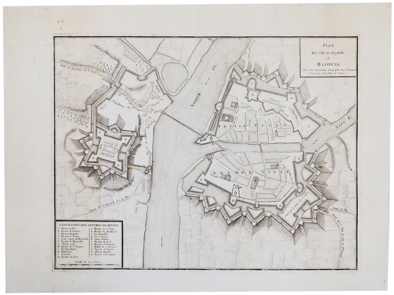
LONGCHAMPS (Sébastian G.).
[BAYONNE] Plan des ville et citadelle de Bayonne.
Paris, Longchamps, [circa 1750]. 355 x 457 mm.
Bookseller reference : LBW-5502
|
|
|
LONGUET.
Département de la Seine Inférieure - Extrait de la Carte topographique de la France, levée par les officiers d'Etat-Major et gravée au Dépôt général de la Guerre sous la direction du Lt. Général Baron Pelet, pair de France, publié avec l'autorisation du ministre de la Guerre.
Paris, Longuet, succ. de Simonneau, 1841. Ensemble complet de quatre grandes cartes (99 X 70 chacune) , échelle 1/80000e, en feuilles et contrecollées sur toile écrue (rousseurs à la toile). La première porte de grands cartouches : division, population, territoire; état indicatif du nombre et du tonnage des batiments entrés dans les ports du département (bureaux principaux des douanes, Le Havre, Rouen, Fécamp, Dieppe). Très bon état pour l'ensemble. Dans son étui de cartonnage en papier marbré, titre en long sur papier rouge. Usagé.
Bookseller reference : 20608

|
|
|
Loose, Hans-Dieter
Hamburg um 1690. NACHDRUCK nach einem kolorierten Kupferstich aus der Werkstatt von Peter Schenk für dem "Atlas Minor sive Tabulae Geographicae praecipuorum Regnorum Regionum, Insularum, Provinciarum etc. Per Carolum Allard", Amsterdam um 1696.
Braunschweig, Archiv-Derlag, [ca. 1985]. Mehrf. gefalt. farb. Plan über einem Panorama der Stadt, von der Elbseite gesehen (Blattgröße ca. 47 x 61 cm; Bildgröße ca. 45,5 x 59,5 cm).
Bookseller reference : 99391
|
|
|
LOPEZ (Don Tomas)
Mapa de la M.N.Y.M.L. Provincia de Guipuzcoa… Madrid, 1770. Une feuille pliée et toilée de 38 x 39 cm.
Madrid, 1770. Une feuille pliée et toilée de 38 x 39 cm
Bookseller reference : 8696
|
|
|
LOPEZ (Don Tomas)
Mapa geografico de una Parte de la provincia de Burgos. Madrid, 1784. Une feuille pliée et toilée de 84 x 87 cm.
Madrid, 1784. Une feuille pliée et toilée de 84 x 87 cm.
Bookseller reference : 8700
|
|
|
LOPEZ (Don Tomas)
Mapa geografico del Partido de Carrion.Madrid, 1785. Une feuille pliée et toilée de 37 x 40 cm.
Madrid, 1785. Une feuille pliée et toilée de 37 x 40 cm.
Bookseller reference : 8699
|
|
|
LOPEZ (Don Tomas)
Mapa geografico del Reyno de Granada.Madrid, 1795. Une feuille pliée et toilée de 75 x 87 cm.
Madrid, 1795. Une feuille pliée et toilée de 75 x 87 cm.
Bookseller reference : 8704
|
|
|
LOPEZ (Don Tomas)
Mapa geografico del Reyno de Jaen.Madrid, 1787. Une feuille pliée et toilée de 37 x 40 cm.
Madrid, 1787. Une feuille pliée et toilée de 37 x 40 cm.
Bookseller reference : 8703
|
|
|
LOPEZ (Don Tomas)
Mapa geografico que comprehende el partido de Santo Domingo de la Calzada y el de Logroño. Madrid, 1787. Une feuille pliée et toilée de 38 x 41 cm.
Madrid, 1787. Une feuille pliée et toilée de 38 x 41 cm.
Bookseller reference : 8701
|
|
|
LOPEZ y VARGAZ MACHUCA (Tomas).
[CASTILLE] Mapa geografico de la provincia de Soria.
Madrid, 1783. En 20 sections gravées, montées sur toile bleue et pliées, formant une carte de 845 x 865 mm.
Bookseller reference : LBW004df
|
|
|
Lord, Walter; b/w photos/maps [Illustrator]
Day of Infamy Pearl Harbor
Henry Holt & Co 1957. Hardcover. Very Good. Henry Holt & Co hardcover
Bookseller reference : 211004140
|
|
|
LOSADA, Juan Cayetano (1766-1846).
Breves Tratados de Esfera y Geografía Universal, con algunas noticias históricas, en especial en lo perteneciente a España, y un Apéndice de Geografía Antigua y otro de Cronología, para instrucción de la juventud.
Madrid, Imprenta de Don Eusebio Aguado, 1839. 8vo. menor; 4 hojas, 246 pp., 1 h. Figuras entre el texto, un estado plegado "Distancia respectiva y número de habitantes de Madrid y de las principales capitales de provincia de España" y 6 mapas plegados coloreados de época. Encuadernación de época en piel.
|
|
|
LOT
Carte d?partementale couleurs au 1/200 000?me. Sans date.
Une feuille. 56x76 cm.
|
|
|
LOT ET GARONNE
Carte d?partementale.
Une feuille 60x80 cm repli?e.
|
|
|
LOT ET GARONNE
Carte d?partementale. Sans date.
1 feuille 50x65 cm repli?e.
|
|
|
Lot, Ferdinand J. J. Gruber, [maps] (illustrator)
Les Invasions barbares et le peuplement de l Europe. Introduction a l intelligence des derniers traites de paix.
Payot Paris 1942 Payot Paris 1942 paperback 349 lightly tanned pp text in French J. J.Gruber maps illustrator light soiling/wear to covers but still in good tight clean reading order. Full refund if not satisfied. 24 hour dispatch. If not pictured in this listing a scan of the actual book is available on request. Soft cover. Fair. Payot, Paris, paperback
Bookseller reference : abc4512
|
|
|
LOTTER (Tobias Conrad).
Planisphærium cœleste secundum restitutionem Hevelianam et Hallejanam.
Augsbourg, Tobias Conrad Lotter, [circa 1760]. 485 x 570 mm.
Bookseller reference : LBW-8679

|
|
|
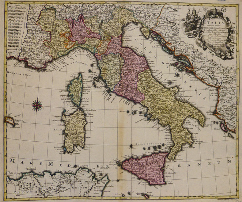
LOTTER (Tobias Conrad);
Italia annexis insulis Sicilia, Sardinia et Corsica.
Augsbourg 1758 476 x 568 mm.
Bookseller reference : LBW-935
|
|
|
Lotter, Gebr.:
Karte von West-Russland. Von 2 Platten gedruckt und in Hochformat zusammengesetzt. Altkolorierte Kupferstichkarte.
Format (Blattgröße): 69 x 48 cm. *Im linken unteren Viertel mit 2 alten Tintenflecken (1 weiterer am Unterrand). Ansonsten sauber und gut erhalten Landkarten de
|
|
|
Lotter, Tobias Conrad
Marchionatus Lusatiae Superioris Felicissimo Polaniae, Regis, Electoris Saxoniae, sceptro florens, Dynastiis et Praefecturis suis distributus nova accuratione Tob. Conradi Lotter Geogr. delineatus in Augusta. [Altkolorierter Original-Kupferstich / original colored copper engraving].
o.J. Tobias Conrad Lotter, geboren 1717, gestorben am 14. Juli 1777. Kupferstecher, Kartograph und Verleger in Augsburg. [2 Warenabbildungen]
Bookseller reference : 12064DB

|
|
|
Lotter, Tobias Conrad
Theatrum belli Rußorum Victoriis illustratum sive Nova et accurata Turcicarum et Tartaricum ... [Altkolorierter Original-Kupferstich / original colored copper engraving].
o.J. [2 Warenabbildungen] Tobias Conrad Lotter, geboren 1717, gestorben am 14. Juli 1777. Kupferstecher, Kartograph und Verleger in Augsburg.
Bookseller reference : 13188DB

|
|
|
Lotter, Tobias Conrad (1717 - 1777):
"Novissimum Astronomiae, Geographiae, ac Gnomonicae compendium theoreticum. Altkolorierter Kupferstich von M. Seutter.
49 x 58 cm. Blatt: 52 x 66 cm. Theoretische und pratische Erklärung: in der Unterhalfte zwei Abb. von einer "Quadranten Uhr" und einer "Äquinoctial oder dem Mittel=kreis gleich ebene Universal Uhr" (je 24:24 cm), daruber der umfangreiche gestochene Erläuterungstext (in Latein). Zwischen den Abb. und dem Text in 2 Kolumnen sind Abb. von Instrumenten. - Unterrand knapp beschnitten, sonst breitrandig. Sauber und sehr gut erhalten. Graphiken de
|
|
|
Lotter, Tobias Conrad:
Nova et accuratißima Ducatus Wurtenbergici cum territoris conterminis. Kupferstichkarte des Herzogtums Württemberg von Tobias Lotter.
Format 50 x 57,5 cm. Blattgröße: 52 x 66 cm. *Mit Grenzkolorit und Markierung der Städte - die Kartuschen nicht koloriert. - Gut erhalten. Landkarten de
|
|
 Receive by email
 Download as PDF document
 RSS feed


