|
LHOTE Jean-Marie
kleber et Marie-Louise
Hachette. 1979. In-4. Relié toilé. Bon état, Couv. convenable, Dos satisfaisant, Intérieur frais. 90p, illustré de reproduction de cartes postales dans le texte, relié toilé noir.. Avec Jaquette. . . Classification Dewey : 741.68-Illustrations des cartes postales
Bookseller reference : RO20017149
|
|
|
Libaek, Ivan and Oivind Stenersen; Color Photos, Maps and Charts [Illustrator]
History of Norway from the Ice Age to the Oil Age
Grondahl & Son Forlag 1991-01-01. Hardcover. New. In shrink wrap. Looks like an interesting title! Grondahl & Son Forlag hardcover
Bookseller reference : Q-8250418522 ISBN : 8250418522 9788250418523
|
|
|
LIBRAIRIE LE BAIL
PORTRAITS DE LA FRANCE ET DU MONDE . Cartes et vues de villes du XVIè au XIXè siècle
LIBAIRIE LE BAIL . 2010 . 117 pages . Broché
Bookseller reference : 8905
|
|
|
Liddell Hart, B. H. & Illus. with Maps
The Real War 1914-1918
Atlantic - Little Brown. Very Good- in Good dust jacket. 1930. early printing;possible 1st. Hardback-. Green clOTH Hb ; gilt lettering; 1930 ande "c" on copyright page; "$6.50" dustjacket price ; jacket in archival mylar; 508 pages . Atlantic - Little, Brown hardcover
Bookseller reference : 1036135
|
|
|
Liechtenstern, Joseph Marx von.
Allgemeine Charte des Kaiserthums Oesterreich, nebst einem grossen Theile Deutschlands, der Schweiz, Italiens, der Türkey, Russlands und Preussens. Wien, Joseph Riedl, 1816.
1410 x 1755 mm. Grenzkolorierte Kupferstichkarte in 9 Blättern, Maßstab ca. 1:900.000. Jedes Blatt in 12 Segmenten auf Leinen aufgezogen. Blatt 9 mit dem Plan "Wien mit seinen Umgebungen". Gefaltet in zeitgenöss. marmoriertem Umschlag und Originalschuber des Verlags mit goldgepr. Rückenschildchen "Kaiserthum Oesterreich". Letzte Auflage dieser ausgezeichneten, erstmals 1809 erschienenen monumentalen Gesamtkarte der Habsburgermonarchie - der "bis dahin weitaus größte[n] gedruckte[n] Karte der Österreichischen Monarchie" (Austria Picta). In dieser Auflage neu dargestellt sind die "im Münchner Vertrag festgelegten Grenzen zwischen Bayern und Österreich" (Dörflinger, S. 607). In ihrem grundlegenden Umfang noch 1805 entworfen, wurde die Karte vom Pressburger Frieden am 26. Dezember 1805 und dann von einem langen Streit zwischen Kartograph und Verlag überholt, sodass die neun Blätter "jenen Raum dar[stellen], der bis Dezember 1805 zur Österreichischen Monarchie gehörte - also auch Tirol und Vorarlberg, Venetien und Dalmatien sowie die Vorlande, wobei sich diese Territorien noch zusätzlich durch ihre dichte Topographie von den angrenzenden nicht-österreichischen Gebieten optisch deutlich abheben [...] Von ganz ausgezeichneter Qualität [ist] der Stich von Joseph Stöber, der die stellenweise Überfüllung mit Einzelheiten weitgehend mildert. Den Großteil von Blatt 9 nimmt die Nebenkarte 'Wien mit seinen Umgebungen' (Maßstab ca. 1:90.000) ein, die das Gebiet zwischen Korneuburg und Vöslau/Ebreichsdorf bzw. zwischen Langenlebarn/Breitenfurt und Fischamend/Ebergassing - also vor allem den südlichen und südöstlichen Teil des Umlandes von Wien - abbildet" (ebda., S. 605f.). - Umschlag und Schuber gering berieben. Vereinzelt kleine Randläsuren an den einzelnen Segmenten. Insgesamt wohlerhalten. Dörflinger 603ff., KIC 31. Vgl. Austria Picta 34.4 (Aufl. von 1811).
|
|
|
Lieutenant-Colonel ROUSSET
La Guerre au jour le jour. 6 volumes : Vol 1: août 1914 - avril 1915 - Vol 2 : avril à décembre 1915 - Vol 3 : Janvier à septembre 1916 - Vol 4 : septembre 1916 à juin 1917 - Vol 5 : juin 1917 à mai 1918 - Vol 6 : juin 1918 au 28 juin 1919. Avec 480 photographies ou dessins, 52 cartes et plans : 50 portraits, 378 scènes de batailles et vues panoramiques. Ouvrage augmenté des récits officiels et des principaux faits de guerre (6 VOLUMES)
1920 A Paris, Société d'Editions et de Publications, Librairie Jules Taillandier - 1920 - 6 vol Grand in-8, demi percaline rouge à coins. 647 + 653 + 653 + 674 + 589 + 587 pages. 480 photographies ou dessins, 52 cartes et plans : 50 portraits, 378 scènes de batailles et vues panoramiques. Ouvrage augmenté des récits officiels et des principaux faits de guerre - PREVOIR AUGMENTATION DE FRAIS DE PORT
Bookseller reference : 81275

|
|
|
Lign
La sarthe. il y a bientot 100 ans
SUTTON 2026 116 pages 24 6x1 8x34 8cm. 2026. Reliure Editeur avec jaquette. 116 pages. L'ouvrage 'La Sarthe' d'André Ligné est un récit historique qui évoque la vie dans le département de la Sarthe au milieu du XXe siècle notamment entre 1944 et 1952. L'auteur historien passionné par son département utilise des photographies et cartes postales anciennes souvent inédites pour illustrer l'évolution des modes de vie des méthodes d'éducation et des perspectives d'avenir avant l'ère du numérique
Bookseller reference : 9432

|
|
|
LILLE
Carte couleurs (de Londres ? Mons et d'Amiens ? Ipswich). Sans date.
Une feuille toil?e 68x51 cm.
|
|
|
LILLE
Plan de poche.
Broch?. 11 pages. Plan 75x56 cm.
|
|
|
LILLE. MANUSCRIT.
Plan de la ville et citadelle de l’Isle.
[circa 1730]. 367 x 496 mm.
Bookseller reference : LBW-540

|
|
|
LILLE...
Nouveau plan de Lille et ses environs. Avec indication des rues, monuments, ?tablisements publics, curiosit?s. Sans date.
Broch?. 24 pages et 1 plan d?pliant hors texte
|
|
|
Lim (8), Mind Maps Journal
Mind Maps Journal: Blank Mind Map BookBrainstorm Notebook Help You Organize Your Thoughts & Take Notes 100 Pages
Independently published 2019. Paperback. New. 102 pages. 11.00x8.50x0.23 inches. Independently published paperback
Bookseller reference : 2-1713091461 ISBN : 1713091461 9781713091462
|
|
|
Lim (?), Mind Maps Journal
Mind Maps Journal: Blank Mind Map BookBrainstorm Notebook Help You Organize Your Thoughts & Take Notes 100 Pages
paperback. Good. Access codes and supplements are not guaranteed with used items. May be an ex-library book. paperback
Bookseller reference : 1713091461.G ISBN : 1713091461 9781713091462
|
|
|
Lim ? Mind Maps Journal
Mind Maps Journal: Blank Mind Map BookBrainstorm Notebook Help You Organize Your Thoughts & Take Notes 100 Pages
paperback. Good. Access codes and supplements are not guaranteed with used items. May be an ex-library book. paperback
Bookseller reference : 1713091569.G ISBN : 1713091569 9781713091561
|
|
|
Limoges, Michel
Objectif : Chalon-sur-Saone
No marks or inscriptions. A lovely clean very tight copy with bright unmarked boards and no bumping to corners. Dust jacket not price clipped or marked or torn or creased with slight traces of handling. 96pp. culture, sport, art, architecture and much more about this area of the Saone in Western France. All text in French. Printed on fine quality paper. Very well illustrated with colour photographs.

|
|
|
Lindbergh Anne Morrow; Lindbergh Charles A. maps by;
North to the Orient
New York: Harcourt Brace and Company 1935. First Edition. Hardcover. 10mo; pp 255; G/Poor; blue spine with ivory text; dust jacket has noticeable chips to edges; some toning to exterior; mylar wraps; cloth has slight wear to exterior; minor wear to corners; strong boards; text block has age toned exterior edges; illustrated endpapers; previous owner's name to verso of ffep; frontispiece; illustrated; interior clean;. 1319874. FP New Rockville Stock. Harcourt, Brace and Company hardcover books
Bookseller reference : 1319874
|
|
|
Lindbergh, Anne Morrow Foreword and maps by Charles A. Lindbergh
Listen! the Wind
London: Chatto and Windus 1938. 1st Edition 1st Printing. Hardcover. Very Good. 8vo - over 7¾ - 9¾" tall. Lindbergh Charles A. maps. First edition first printing. Octavo hardback xii 275 pp. Maps Blue cloth gilt decoration. Very slight foxing on outer edge of page block otherwise Very Good condition No inscriptions <br/> <br/> Chatto and Windus hardcover
Bookseller reference : 093886
|
|
|
Lindbergh, Ann Morrow maps & foreword: Charles A. Lindbergh
LISTEN! THE WIND
New York NY: Harcourt Brace & Company. Good/Fair. 1938. First Edition. Hardcover w/DJ. 8vo. 275 pp. DJ rubbed frayed chipped page toning . Harcourt, Brace & Company hardcover
Bookseller reference : BOOKS334566
|
|
|
Lindbergh, Anne Morrow; Lindbergh, Charles A. [maps]
NORTH TO THE ORIENT Inscribed
New York: Harcourt Brace and Company 1935. First Edition Fourth Printing. Hardcover. Octavo 255 pages. In Very Good minus condition and lacking issued dust jacket. Bound in dark blue cloth with silver gilt lettering on spine. First edition fourth printing as stated on copyright page. Foxing to boards with light fraying to cloth along edges. Top edge of textblock dyed dark blue though faded. Toning to interior pages and tanning to pastedowns. Inscribed by Anne Morrrow Lindbergh on second endpaper in Spanish. Shelved in Case 9. 1395167. Shelved Dupont Bookstore. Harcourt, Brace and Company hardcover
Bookseller reference : 1395167
|
|
|
Lindbergh, Anne Morrow [Charles Lindbergh (maps)]
North to the Orient
New York: Harcourt Brace & Company 1935. 1st edition. Very Good. octavo. orig. cloth 255pp. frontis. b/w pls. maps appendix In 1931 Charles A. Lindbergh flew together with his wife Anne Morrow Lindbergh who acted as radio operator to China. He used a single engined Lockheed Sirius on floats. They flew from Washington D.C. across Canada & Alaska to Japan and then into China. Front hinge tender o/w VG copy Harcourt, Brace & Company hardcover
Bookseller reference : 64623
|
|
|
Lindbergh, Anne Morrow.
NORTH TO THE ORIENT. WITH MAPS BY CHARLES A. LINDBERGH.
255p. + Photo frontis. Text and endpaper maps by Charles A. Lindbergh. Endpapers browned. First few leaves foxed. 8vo. Original full cloth binding, decorated and lettered in white. Binding slightly worn. Hardbound. Tenth printing. AIR/1
|
|
|
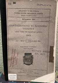
Lindgren, Waldemar & Maps
Contributions to Economic Geology 1911 Part I Short Papers and Preliminary Reports Part 1 Metals and Non Metals Except Fuels
Washington D. C.: Government Printing Office 1913. First Edition. Softcover. Fair with no dust jacket. Unmarked except for stamps and stickers on front cover. Spine is reinforeced with black tape and title is written on spine. Covers are worn on edges and have nicks and missing corners. Well bound otherwise. ; Book Description; Pages are clean and not marred by notes or folds. Covers are square with wear as noted. Ships Safe and Fast. ; U. S. Geological Survey Bulletin; Textbook; Vol. 530; B&W Illustrations; 8vo 8" - 9" tall; 400 pages DC4. Government Printing Office unknown
Bookseller reference : 18831
|
|
|
LIOZU (Jacques).
[ALSACE/LORRAINE] Alsace - Lorraine.
Paris, Odé, 1951. 490 x 330 mm.
Bookseller reference : LBW-6307

|
|
|
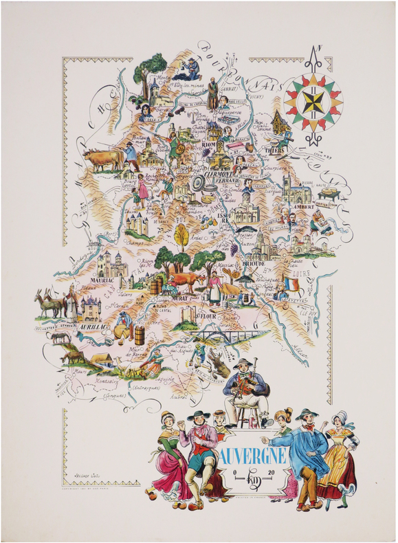
LIOZU (Jacques).
[AUVERGNE] Auvergne.
Paris, Odé, 1951. 483 x 340 mm.
Bookseller reference : LBW-7564
|
|
|
LIOZU (Jacques).
[BOURGOGNE] Bourgogne.
Paris, Odé,. 1951 478 x 339 mm.
Bookseller reference : LBW-7538

|
|
|
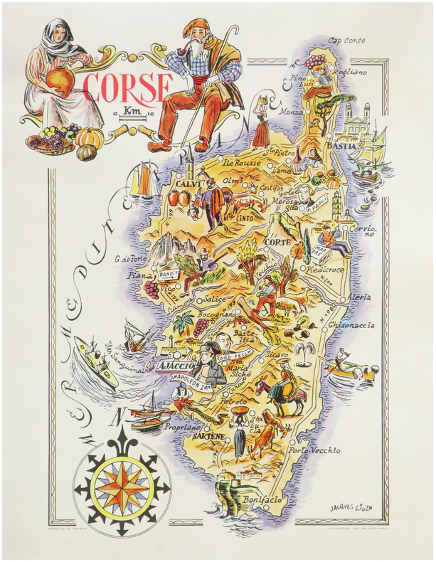
LIOZU (Jacques).
[CORSE] Corse.
Paris, Odé, 1951. 410 x 295 mm.
Bookseller reference : LBW-7360
|
|
|
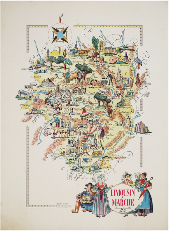
LIOZU (Jacques).
[LIMOUSIN] Limousin et Marche.
Paris, Odé, 1951. 493 x 335 mm.
Bookseller reference : LBW-7563
|
|
|
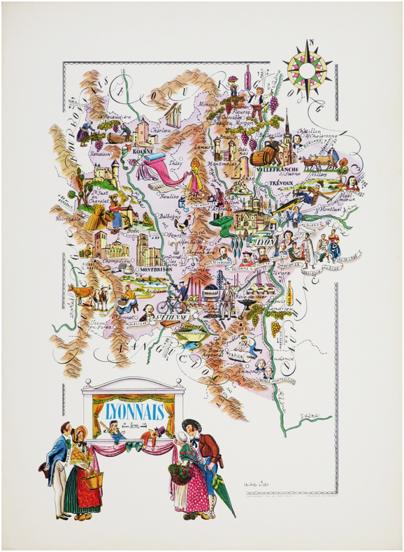
LIOZU (Jacques).
[LYONNAIS] Lyonnais.
Paris, Odé, 1951. 490 x 330 mm.
Bookseller reference : LBW-7027
|
|
|
LIOZU (Jacques).
[NORD] Provinces du Nord.
Paris, Odé, 1951. 320 x 484 mm.
Bookseller reference : LBW-7552

|
|
|
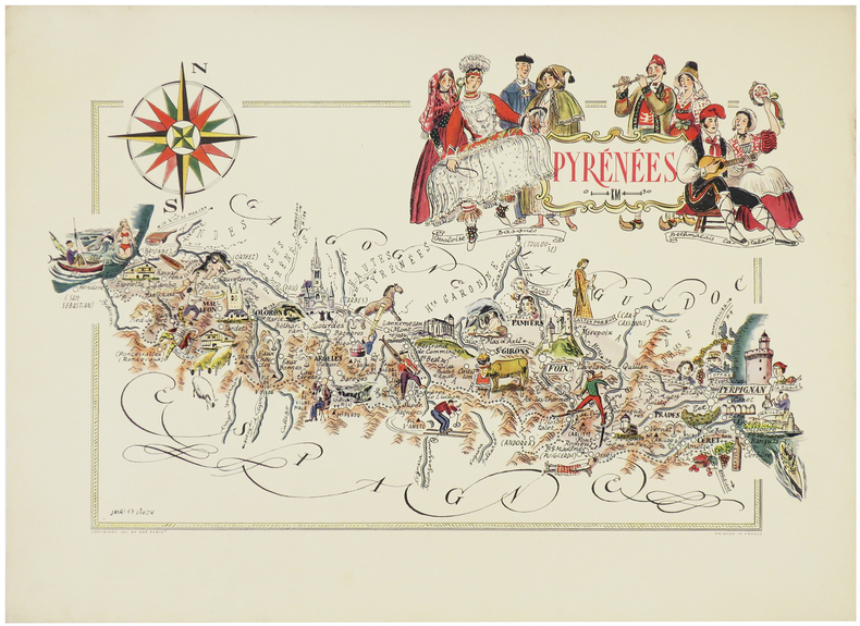
LIOZU (Jacques).
[PYRÉNÉES] Pyrénées.
Paris, Odé, 1951. 312 x 495 mm.
Bookseller reference : LBW-6301
|
|
|
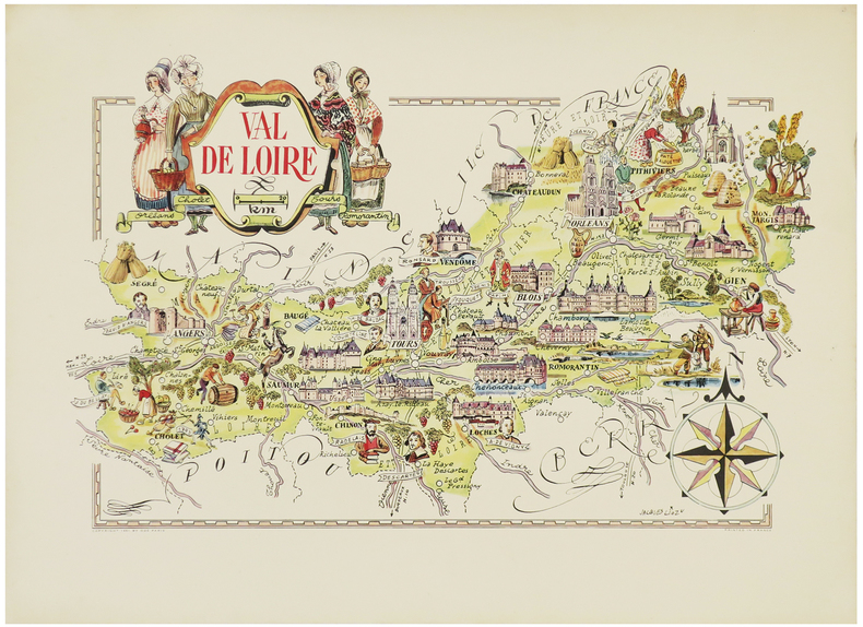
LIOZU (Jacques).
[Val de LOIRE] Val de Loire.
Paris, Odé, 1951. 310 x 490 mm.
Bookseller reference : LBW-6305
|
|
|
LIOZU (Jacques).
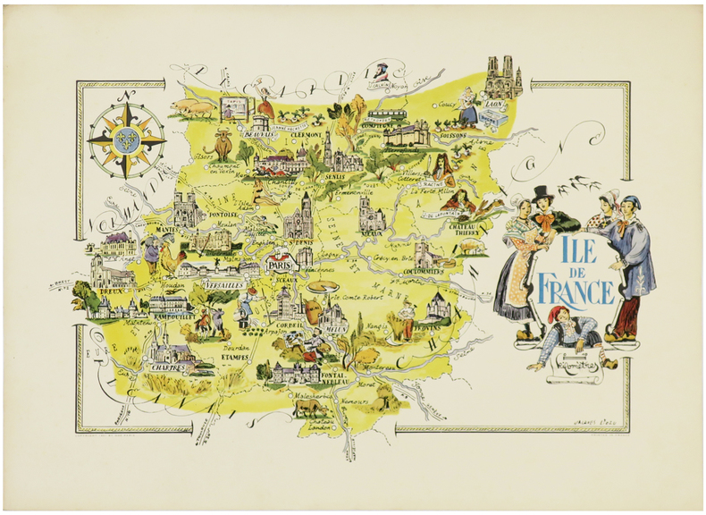
[ÎLE-de-FRANCE] Île de France.
Paris, Odé, 1951. 330 x 484 mm.
Bookseller reference : LBW-6302
|
|
|
LIOZU (Jacques).
Amérique du Sud.
Paris, Odé, 1951. 485 x 390 mm.
Bookseller reference : LBW-7562

|
|
|
LIOZU (Jacques).
Europe centrale & orientale.
Paris, Odé, 1951. 488 x 356 mm.
Bookseller reference : LBW-7561

|
|
|
List of clan names Index of family crests and related maps
Japan's famous families by region 10 Shikoku edition
new person oraisha 1988. Soft Cover. Fine. Volume: 1 new person oraisha paperback
Bookseller reference : 2083002117402793
|
|
|
List of clan names Index of family crests and related maps
The history of the rise and fall of Chinese noble families Japan's noble families by region 9
new person oraisha 1989. Soft Cover. Fine. The book is in fine condition. new person oraisha paperback
Bookseller reference : 2083002117402765
|
|
|
Littérature Policière - Rivages / Noir
Série complète 12 cartes postales publicitaires pour la collection Rivages/Noir ( Neuf, scellé ).
Editions Rivages sans date. Magnifique série complète de 12 cartes postales publicitaires pour la collection Rivages/Noir au format 10 x 15 cm. Reproductions de couvertures de roman de James Ellroy, James Lee Burke, Sean Doolittle, Robert Bloch, Tony Hillerman, Bill James, Louis Sanders, David Goodis, Donald Westlake, Paco Ignacio Taibo II, Barouk Salamé & David Peace. Edition originale hors commerce. Etat de neuf sous blister.
Bookseller reference : 22029

|
|
|
Livingston, Helen
Hampshire, The New Forest and The Isle of Wight
No marks or inscriptions. No creasing to covers or to spine. A lovely clean very tight copy with bright unmarked boards and no bumping to corners. 128pp.

|
|
|
LIVINGSTONE David
Explorations dans l’intérieur de l’Afrique Australe et voyage à travers le continent de Saint-Paul de Loanda à l’embouchure du Zambèze de 1840 à 1856.
Ouvrage traduit de l’anglais avec l’autorisation de l’auteur par Mme H.LOREAU.In 8 demi-chagrin rouge époque titre,fer,roulette filet dorés, filets à froid.Faux-titre, grande vue dépliante(chute du Zambèze)en frontispice, titre,1 page,1 portrait de l’auteur,688 pages,un appendice de 4 pages:situation des lieux visités par le docteur LIVINGSTONE.Nombreuses gravures Hors-texte, une coupe idéale du centre de l’Afrique Australe(dépliante.Une grande carte dépliante,détaillée de l’itinéraire suivi par le Dr LIVINGSTONE.Une carte dépliante de l’Afrique Australe indiquant les voyages du révérend docteur LIVINGSTONE. Hachette & Cie 1877.Très bon état,pratiquement sans rousseurs.
Bookseller reference : 5665

|
|
|
LIVINGSTONE David et Charles
Explorations du Zambèze et des ses affluents et découverte des Lacs CHIROUA et HYASSA 1858-1864
ouvrage traduit de l’anglais avec l’autorisation des auteurs par Mme H.LOREAU in 8 demi-chagrin rouge époque, titre,roulette,filets dorés,filets à froid.Faux-titre, titre IV 588 pages,47 gravures hors-texte,complet des quatre cartes dépliantes en fin de volume.Hachette & Cie 1881.Rousseurs éparses,sinon Très bon état 262 LIVINGSTONE David révérend docteur Explorations dans l’intérieur de l’Afrique Australe et voyage à travers le continent de Saint-Paul de Loanda à l’embouchure du Zambèze de 1840 à 1856. Ouvrage traduit de l’anglais avec l’autorisation de l’auteur par Mme H. LOREAU. In 8 demi -chagrin rouge époque titre, fer, roulette filet dorés, filets à froid. Faux-titre, grande vue dépliante (chute du Zambèze) en frontispice, titre, 1 page, 1 portrait de l’auteur, 688 pages, un appendice de 4 pages : situation des lieux visités par le docteur LIVINGSTONE. Nombreuses gravures Hors-texte, une coupe idéale du centre de l’Afrique Australe (dépliante). Une grande carte dépliante, détaillée de l’itinéraire suivi par le Dr LIVINGSTONE. Une carte dépliante de l’Afrique Australe indiquant les voyages du révérend docteur LIVINGSTONE. Hachette & Cie 1877. Très bon état, pratiquement sans rousseurs. 250€
Bookseller reference : 5664

|
|
|
LIVINGSTONE David et Charles:
Explorations du Zambèse et de ses affluents et découverte des lacs Chiroua et Nyassa en 1858 - 1864. Traduit de l'anglais avec l'autorisation de l'auteur par Mme H. Loreau.
Paris, Librairie de L. Hachette et Cie, 1866. In-8 de [8]-580 pages, demi-percaline verteà coins, à la Bradel, étiquette de titre en maroquin brun, non rogné, couvertures et dos conservés.
Bookseller reference : 20538
|
|
|
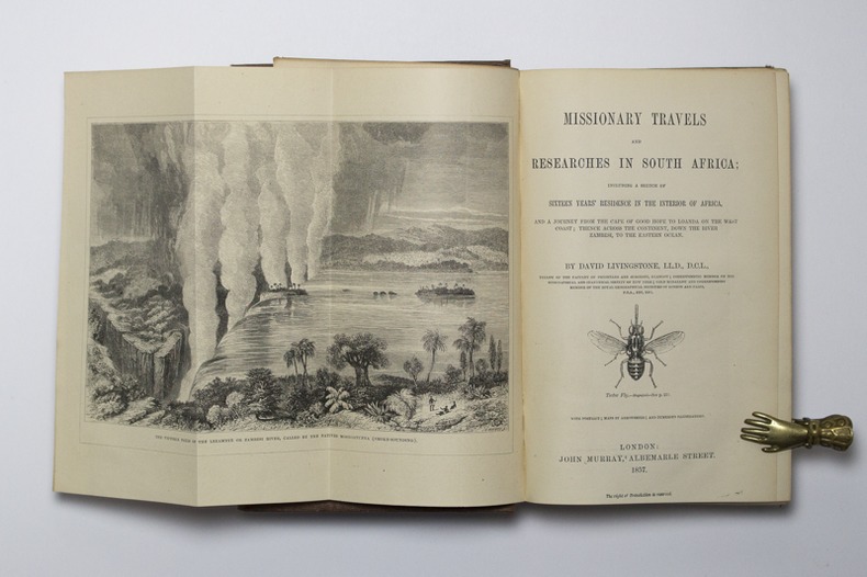
LIVINGSTONE David:
Missionary Travels and Researches in South Africa; including a Sketch of Sixteen Years' Residence in the Interior of Africa, and a Journey from the Cape of Good Hope to Loanda on the West Coast; thence across the Continent, down the River Zambezi, to the Eastern Ocean.
London, John Murray, 1857. Petit in-4 de IX-[1]-687-8 pages, pleine percaline brune décorée à froid. Etiquette de la librairie Desrogis, à Genève (de l'époque de la publication de l'ouvrage). Infime fente à la coiffe supérieure. Etiquette du relieur: Edmonds & Remnants.
Bookseller reference : 14921
|
|
|
Livingstone, W. (editor)
The Sunny South Holiday Guide 1965
No marks or inscriptions. No creasing to covers, creases to spine. A very clean crisp very tight copy with bright unmarked very slightly sunned boards and no bumping to corners. 696pp. Very detailed work covering almost 90 resorts across the south of England. How to 'holiday' in 1965.

|
|
|
Ljapidus, L. V. Petrenko, J. F. ; Glav. upravlenije geodezii i kartografii pri Sovete ministrov SSSR.
Politiko-Administrativnaja karta CCCP
1 multi-fold, multi-color map housed in stiff pink printed wraps/ Scale: 1: 8,000,000 mapa : 134 x 202 cm. In Russian. Finely detailed map of the former Union of Soviet Socialist Republics (USSR). Very large ( approx 2 x 4.5 feet)
|
|
|
LLOPIS LLADÓ, N. - COLL, Xavier
SERRA DEL CADÍ - Granollers 1958 - Mapa
Granollers, Editorial Alpina, 1958. Pedraforca - Serra Pedregosa - Tancalaporta - Cadinell - Costa Freda. Mapa topográfico y notas explicativas. Escala 1:25.000. Mapa entelado y plegado. Buen ejemplar.
|
|
|
LLOPIS, N.
MOIXARÓ - Granollers 1958 - Mapa
Granollers, Editorial Alpina, 1958. Mapa topográfico excursionista. Escala 1:25.000. Mapa entelado y plegado. Buen ejemplar. Tossa d Alp - La Moixa - El Pendís - Coll de la Bauma - Gisclareny
|
|
|
LLOPIS, R.
ANDORRA III. BAIX VALIRA - Granollers s/f- Mapa
Granollers, Editorial Alpina, s/f. Mapa topográfico excursionista. Escala 1:25.000. Mapa entelado y plegado. Muy buen ejemplar.
|
|
|
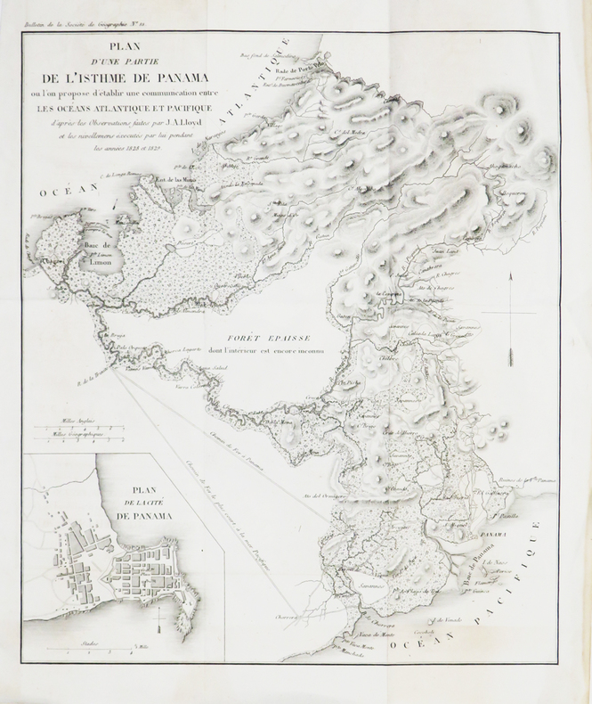
LLOYD (John Augustus).
[CANAL de PANAMA] Plan d'une partie de l'isthme de Panama où l'on propose d'établir une communication entre les océans Atlantique et Pacifique.
[1830]. 287 x 201 mm.
Bookseller reference : LBW-4815
|
|
|
LLOYD Général Henry, Humphrey, Evans:
Introduction à l’histoire de la guerre en Allemagne, en M. DCC. LVI. entre le Roi de Prusse, et l’Impératrice-Reine avec ses alliés. Ou Mémoires militaires et politiques du général Lloyd.
Londres, Chez A.F. Pion, 1784. In-4 de LXXII-218-[2]-V pages, plein veau marron, dos à nerfs orné. Dos frotté, mors fendus, coiffes manquantes, plats frottés avec manque au 2nd plat.
Bookseller reference : 1652

|
|
|
Lloyd, Nancy
Observing Our Peninsula's Past: The Age of Legends Through 1931, Volume One of the Chinook Observer Centennial Project
A clean, unmarked book with a tight binding. 10 3/4"w x 8 3/8"h. 168 pages. Many b&w illustrations and photographs.

|
|
 Receive by email
 Download as PDF document
 RSS feed


