|
:
Carte de France de l'Etat-Major au 1/80,000. Feuille 11. ABBEVILLE.
Very detailed lithographed topographical map, 52x83.5cm + margins, dissected and mounted on linen, folding back into orig. blind-stamped cloth covers of 20.5x12.8cm. Very good.
|
|
|
:
Carte géologique de France. Echelle 1:80,000. Feuille 84. MIRECOURT.
Chromolithographed map, 50x80cm, dissected and mounted on linen, floding back to 8vo size. Few traces of handling, some light foxing.
|
|
|
:
Carte géologique de l'Algérie. Troisième édition, rectifiée et complétée par la Service de la Carte géologique de l'Algérie [...].
Chromolithographed map, scale 1:800,000, in 4 sheets of 49x66cm + broad margins each, dissected and mounted on linen, folding back to 21.5x20.5cm. Very good. - Final edition of the first large-scale general geological map of Algeria, first published in 1881 as "Carte géologique provisoire"by Pomel and Pouyanne.
|
|
|
:
Carte géologique et agronomique du Département du Haut-Rhin à l'échelle du 1/100.000.
Coloured map, 103x73cm + margins. Folded. With booklet of explanat. text of 31 pp. 4to. Orig. wrs.
|
|
|
:
Forstliche Übersichtskarte des Königreichs Bayern diesseits des Rheins in sechs Blättern.
Very detailed (rivers, villages, wooded areas) lithographed map, scale 1:200,000, in six sheets of 68x92cm each. Some small repairs to blank verso (mostly to margins) not affecting printed area, some dust- or finger-marking, folded vertically one time; over all a good set. The map was intended to be coloured but this is a set in uncoloured state. Rare.
|
|
|
:
Geologische Kaart van Nederland. Schaal 1:50 000. 62 Heerlen. Kwartblad I, II, III, IV.
Coloured geological map in 4 sheets, each 40x55cm, incl. colour key in side margins and col. section in lower margin, dissected and mounted on linen, folding back to 25x10cm. Fine.
|
|
|
:
Lugano e dintorni. / Lugano und Umgebung. Überdruck aus dem Siegfried-Atlas. 1:25,000.
Very detailed chromolithographed map, 58x58cm, mounted on linen, dissected and folding back to size of 20x12cm. Printed front and rear cover mounted on front and back of folded-in stale.
|
|
|
[ BULLET, J.-B. ]
RECHERCHES HISTORIQUES SUR LES CARTES A JOUER, par l'auteur des mémoires sur la langue celtique
Lyon 1757 in 12 (17,5x11) 1 volume reliure pleine basane fauve granitée de l'époque, dos lisse orné, pièce de titre de cuir vert, 163 pages [1]. Ex-libris gravé illustré de J.-B. Mercier (daté 1902). Bel exemplaire de ce très rare ouvrage
Bookseller reference : 16807
|
|
|
[ Holscher, Georg]. Andrew Mitchell
A Guide To Cologne.
Koln Am Rhein: Hoursch & Bechstedt 1904 circa. 20th Improved edition. Paperback. Good. 16mo 60 iv pages coloured folding map at rear; lower corners of margins of final two leaes of ads torn away; clothbacked pictorial chromolithographed wrappers. Scarce. <br/><br/>This edition has more pages than any other located edition. WorldCat does not cite a copy of this edition but dates the 21st edition to 1906. Thus Koln as it was before both world wars. Note: Uknown No Copy Located Elsewhere. Translated by Andrew Mitchell. Hoursch & Bechstedt paperback
Bookseller reference : 0006848
|
|
|
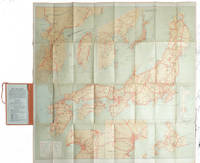
[1920S TOURIST MAP - JAPAN, KOREA AND TAIWAN].
Travelers' Map of Japan Chosen Korea Taiwan Formosa with Brief Descriptions of the Principal Tourist Points in Japan. 1927.
Tokyo.: Japanese Government Railways. Circa1927. Large folding colour map 78.5 x 80 cm of Japan and Korea 6 inset maps one of which shows Taiwan scale 1:1640000 for Hondo Shikoku and Kyushu 1:2340000 for Chosen; tipped into the original orange cloth covered case with orange ties text in 31 panels on the verso one a little age-toned a few very small fold splits without loss a very good copy. Attractive tourist map for the English-speaking traveller issued by the Japanese Government Railways with extensive notes for tours and points of interest on the verso short descriptions of cities and sites to visit principal theatres with suggestions for cafes restaurants and department stores. . Japanese Government Railways. hardcover
Bookseller reference : 215711
|
|
|
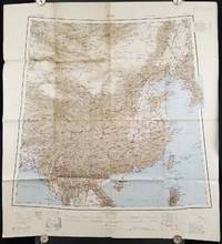
[1945 MAP OF CHINA]
China.
Calcutta: Compiled and drawn by the Survey of India. Second Edition. 1945. Large folding colour map 77.5 x 80cm; 95.5 x 86.2cm sheet including legend and small inset showing adjoining maps light toning and wear to upper margins and at corners and folds; but in very good condition. Very large clear map of China printed in 1945. The projection is noted as the "Lambert Conical Orthomorphic" a polyconic projection employed by the exhaustive Survey of India and the map includes surrounding countries: Taiwan Korea French Indo-China with a small inset key to Korean place-name abbreviations. As is typical of maps of this period Arunachal Pradesh is shown as Tibetan territory.The legend lists borders and provinces railways roads and canals with topography indicated with colouration. . Compiled and drawn by the Survey of India. unknown
Bookseller reference : 206545
|
|
|
[Absinthe]
Absinthe. grande carte postal façon plaque émaillée.
Carte postale sur plaque métal, avec système de suspension. Format 15 x 21 cm., toute neuve sous emballage d'origine.
Bookseller reference : 21299

|
|
|
[Affiche]
La carte à jouer, donation Paul Marteau. Bibliothèque nationale, du 17 janvier au 11 février 1967.
Paris Bibliothèque nationale 1967 aucune reliure Paris, Bibliothèque nationale, 1967. Aucune mention d'imprimeur. 55 x 41,5 cm, affiche en couleurs entièrement faite au pochoir.
Bookseller reference : 4441

|
|
|
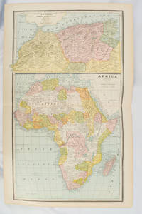
[AFRICA - MAP] CRAM, GEORGE F.
Africa and N. W. Africa Morocco Algeria & Tunis.
Chicago.: Geo. F. Cram. 1894. Chromolithographed maps 54.3 x 34.1 cm sheet central fold a few small edge tears and marginal age toning but in very good condition. Detailed maps prepared for George F. Cram's 1894 "Standard American Atlas": one of the first American firms to publish a world atlas. Maps of Oceania and South Africa printed on the verso. . Geo. F. Cram. unknown
Bookseller reference : 177068
|
|
|
[AFRICA - MAP].
Africa and the Adjacent Islands.
New York.: Ivison Blakeman Taylor & Co. circa1877. Printed colour map 27.5 x 21.7 cm large inset of Northern Africa and a smaller of Southern Africa two small edge tears lower corner neatly strengthened the sheet toned but the map in good condition unrelated text printed on the verso. Map of Africa as a whole before the Imperial race for colonies in the 1880s with interesting insets of Northern and Southern Africa. . Ivison, Blakeman, Taylor & Co. unknown
Bookseller reference : 177229
|
|
|
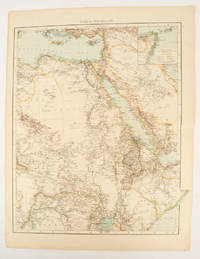
[AFRICA - MAP].
Africa North-East.
London.: Times Atlas of the World. 1895. Double-page folding map printed in colour 46.5 x 36.5 cm. edges gilt central fold with an inset map of Somaliland Somalia and the island of Sokotra key to European possessions outlined in colour small edge fold tears affecting the margin only and two other small edge tears slight toning at the edgaes but in very good condition. Attractive and detailed map prepared for the first edition of "The Times Atlas of the World". . (Times Atlas of the World). unknown
Bookseller reference : 175108
|
|
|
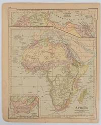
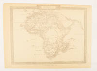
[AFRICA - MAP]. RAPKIN, J.
Africa.
London.: The London Printing and Publishing Company. Circa1880s. Printed map 24 x 32.1 cm decorative border two original vertical folds paper toned mainly at the edges inner margin of the sheet ragged but in good order. A late edition of the map used for the well-known Tallis map this without the characteristic vignettes and on thinner paper. . The London Printing and Publishing Company. unknown
Bookseller reference : 174956
|
|
|
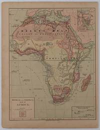
[AFRICA - PRE-COLONIAL ERA MAP]
Physical and Political Map of Africa.
New York.: Harper & Brothers. circa1877. Chromolithographed map with outlne handcolour 27.1 x 21 cm major towns marked with a red cross relief by hachures ocean currents marked two inset maps of the Suez canal and Mascarene Island two very small marginal edge tears not affecting the map slight toning unrelated text on the verso prepared for "Harper's School Geography" in very good condition Interesting map of Africa before the escalation of the European race for colonial possessions from 1880. The map shows: the European possessions of the Cape Colony Transvaal Republic Orange River Republic and Natal; regions of the continent as fertile belts and desert belts; and indicates agricultural and other production such as palm oil ivory skins and cattle. Major cities are shown with important trade centers highlighted with a red cross. Prepared for US students in "Harper's School Geography" longitude is shown from the Greenwich prime meridian at the head of the map and from the Washington prime meridian at the foot. A small outline map of Ohio is included for relative scale. . Harper & Brothers. unknown
Bookseller reference : 176015
|
|
|
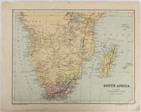
[AFRICA - MAP].
South Africa.
Edinburgh & London.: W. & A. K. Johnston. circa1877. Printed colour map 25 x 32.5 cm edge tears one affecting the lower border only two small chips from the upper margin corner repaired the map in very good condition. Map of North America with a small inset of the British Isles on the verso. Map of Southern Africa before the Scramble for Africa in the late 19th Century. . W. & A. K. Johnston. unknown
Bookseller reference : 177228
|
|
|
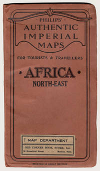
[Africa Maps]; Philip George
PHILIPS' AUTHENTIC IMPERIAL MAP FOR TOURISTS & TRAVELLERS: AFRICA NORTH-EAST
London: George Philip & Son Ltd. ca.1900. Early printing of this map by the cartographic publishing company. Finely rendered in colours. Large multi-folding map approximately 22" x 27" publisher's original protective wrappers printed in black. A very fine copy pristine and very near to mint. George Philip was born in Huntly Aberdeenshire to a staunchly Calvinist family but in 1819 George traveled to Liverpool where his brother Robert who was a nonconformist minister lived. In 1819 he became assistant to the Liverpool bookseller William Grapel and in 1834 set up his own business as a bookseller and stationer in Paradise Street Liverpool. He rapidly expanded the business by producing books particularly educational works and maps. Within his first year of trading to keep up with demand he had to move his business into larger premises at the Atlas Buildings in South Castle Street. <br> Philip used cartographers such as John Bartholomew the elder August Petermann and William Hughes to produce maps on copper plates. Philip then had these printed and hand-coloured by his women tinters. By the time he produced his county maps of 1862 he was using machine coloured maps produced on power-driven lithographic presses. 'His maps ranged from the expensive Imperial Library Atlas 1864 to an atlas costing as little as 3d. and although the bulk of his production was for the commercial and particularly the educational market he also produced important scientific maps notably of North America especially the Arctic and Pacific Northwest Africa and of the West Indies.<br> This is a very fine copy of a scarce map showing the extent of European possessions in North-East Africa before the end of the colonial period. George Philip & Son, Ltd. unknown
Bookseller reference : 29227
|
|
|
[Aguétant (Pierre)] Vacaresco (Hélène. Bucarest, 1864-1947).
Important dossier manuscrit :
1- Tapuscrit signé, corrigé à la main de la Préface du Poème du Coeur (1914) ; in-4, 6 ff. 2- Manuscrit de la Préface du Poème du Beaujolais ; in-4, 7 ff. 3- "Pierre Aguétant jugé par l'amie de Carmen Sylva" : tapuscrit signé, corrections autographes ; in-folio, 5 ff. 4- Tapuscrit signé "À ajouter à la Préface. Paris 25 février 1923" ; in-4, 2 pp. ; passages autographes signés. 5- Correspondance (15 pièces) avec Pierre Aguétant : L.A.S. et cartes postales de 1913 à fin 1925.
Bookseller reference : 12832
|
|
|
[ALLEMAGNE] SEUTER (Matthaeus) - HOMMAN (Johann Baptist).
BRANDEBOURG - MISNIE - LISENACH - HIDELSHEIM.
Augsbourg, s.d. (1730), Nuremberg, sans date (1730). Quatre cartes entoilées, 60 x 54 cm, repliées dans un étui, dont trois en couleurs. Etui en basane fauve d'époque, roulette dorée sur les plats, dos orné avec le titres des cartes.
Bookseller reference : 18568

|
|
|
[ALSACE] - COLLECTIF (Sous la direction de César-François CASSINI de THURY (1714-1784), cartographe)
Carte de Neuf-Brisach, dite de l'Académie, ou de Cassini.-N° 164.-Feuille 77ème.
S. l. (France), S. é., s.d. (vers 1750) ; 1190 x 2008 mm, feuille en papier vergé de 60 x 91 cm, carte pliée. Carte représentant, au nord, Neubrisack (rive gauche du Rhin) et Vieux Brisack (rive droite du Rhin), au sud Mulhausen (rive gauche du Rhin), le Marquisat de Duriach (rive droite du Rhin), à l'échelle de dix mille toises (1/86 400). Technique de reproduction par impression en taille-douce.
Bookseller reference : _202000544

|
|
|
[ALSACE] - COLLECTIF (Sous la direction de César-François CASSINI de THURY (1714-1784), cartographe)
Carte de Neuf-Brisach, dite de l'Académie, ou de Cassini. - N° 164. - Feuille 77ème.
S. l. (France), S. é., s.d. (vers 1750); 1190 x 2008 mm, feuille en papier vergé de 60 x 91 cm, carte pliée. Carte représentant, au nord, Neubrisack (rive gauche du Rhin) et Vieux Brisack (rive droite du Rhin), au sud Mulhausen (rive gauche du Rhin), le Marquisat de Duriach (rive droite du Rhin), à l'échelle de dix mille toises (1/86 400). Technique de reproduction par impression en taille-douce.

|
|
|
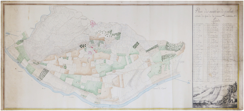
[ANONYME].
[ARIÈGE] Plan des maiteries de Génibat extrait du plan de la commune de Montoulieu.
[vers 1830]. En deux feuilles jointes de 52 x 118 cm.
Bookseller reference : LBW-7461
|
|
|
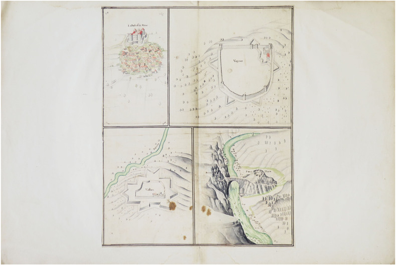
[ANONYME].
[ARDÈCHE] La Bastide de Virac. Vagnas. Vallon. Pont et Fort Darc.
[fin du XVIIe siècle]. Dessin sur une feuille de 445 x 350 mm, elle-même montée sur une feuille de 490 x 740 mm (montage du XVIIIe siècle).
Bookseller reference : LBW-8636
|
|
|
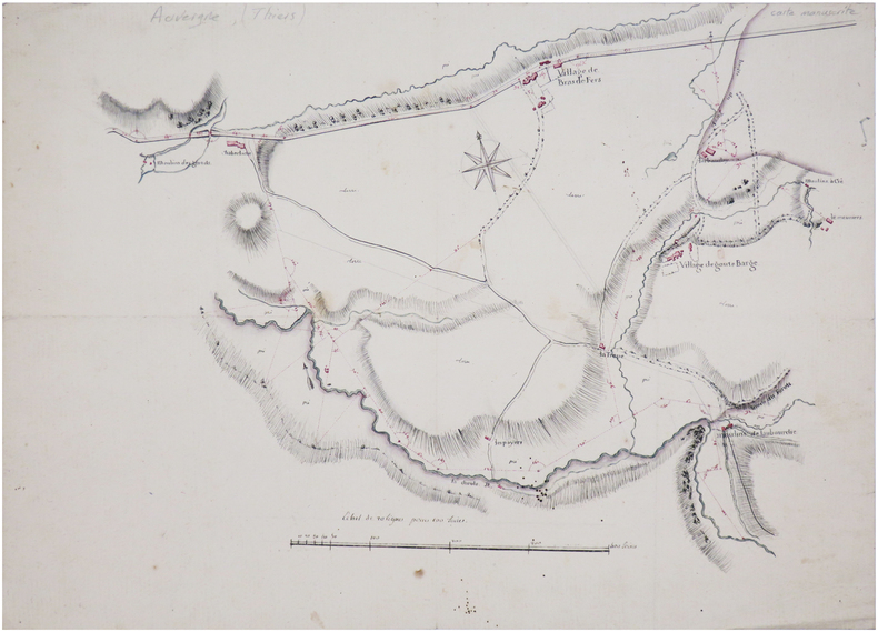
[ANONYME].
[AUVERGNE] Plan de la route de Thiers à Lion [?].
[début du XIXe siècle]. 34,5 x 49 cm.
Bookseller reference : LBW-7434
|
|
|
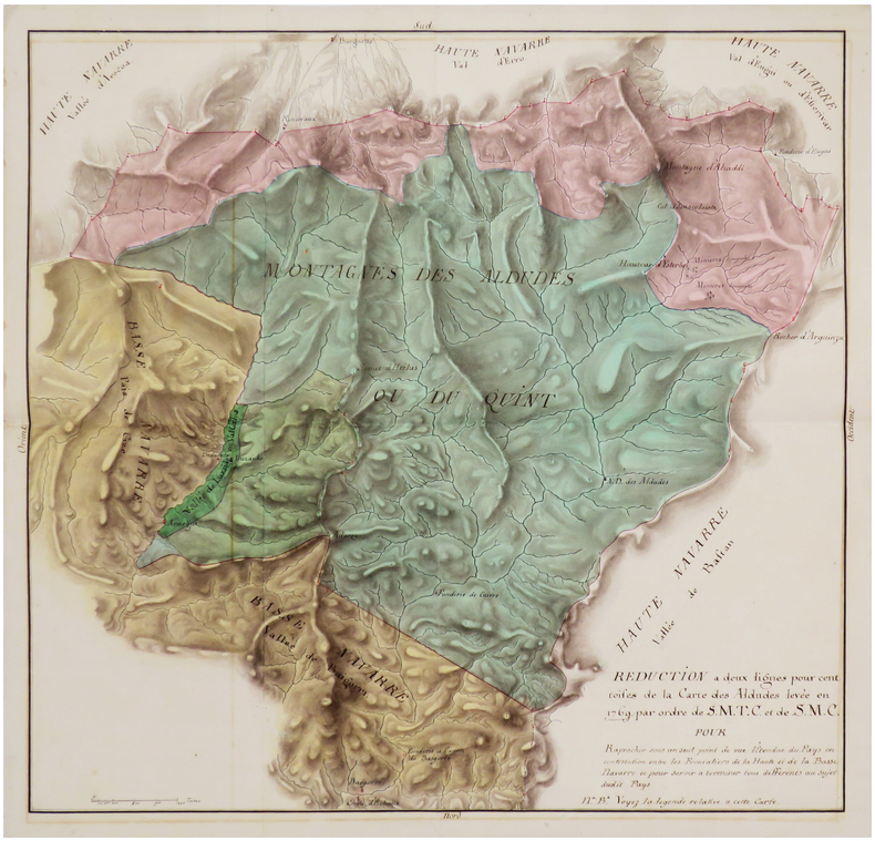
[ANONYME].
[BASSE-NAVARRE] Réduction à deux lignes pour cent toises de la carte des Aldudes par ordre de S.M.T.C. et de S.M.C. pour raprocher sous un seul point de vue l'étendue du pays en contestation entre les frontaliers de la Haute et de la Basse Navarre et pour servir à terminer tous différents au sujet dudit pays.
[vers 1770]. 53 x 54,4 cm.
Bookseller reference : LBW-7476
|
|
|
[ANONYME].
[BAGNÈRES-de-BIGORRE] Plan de Bagnères en Bigorre.
Paris, Lattré, 1789. 423 x 476 mm.
Bookseller reference : LBW-7611

|
|
|
[ANONYME].
[BASSIN d'ARCACHON].
[circa 1890]. 405 x 439 mm.
Bookseller reference : LBW-7933

|
|
|
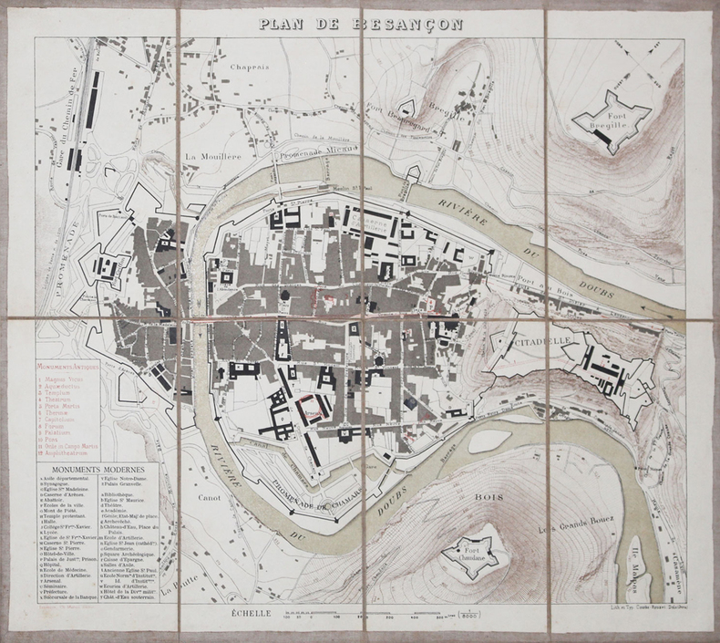
[ANONYME].
[BESANCON] Plan de Besançon.
Besançon, Ch. Marion, [vers 1880]. En 8 sections montées sur toile et pliées, formant un plan de 322 x 367 mm.
Bookseller reference : LBW-3211
|
|
|
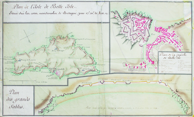
[ANONYME].
[Belle-Île-en-Mer].
[Milieu du XVIIIe siècle]. 35 x 57,5 cm, sur une feuille de 37 x 60 cm.
Bookseller reference : LBW-6588
|
|
|
[ANONYME].
[BREST] Plan des environs de Brest, d'après les travaux exécutés par les ingénieurs hydrographes, sous la direction de M.r Beautemps-Beaupré.
[début du XIXe siècle]. 540 x 600 mm sur une feuille de papier Whatman de 640 x 715 mm (filigrane en haut et à gauche).
Bookseller reference : LBW-8855

|
|
|
[ANTILLES] — SCHMIDT (Emil) & GOERING (Theodor).
[CANNE à SUCRE] Zuckerrohr - Saccharum officinarum.
Leipzig, F.E. Wachsmuth, [vers 1900]. Lithographie originale (66 x 87 cm), montée sur toile, entre deux baguettes de bois.
Bookseller reference : LBW-8670

|
|
|
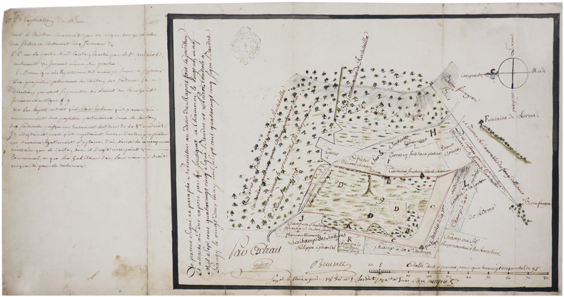
[ANONYME].
[CHER/BERRY] [Carte des fouilles de La Tourate].
[vers 1860]. 39 x 54 cm.
Bookseller reference : LBW-7459
|
|
|
[ANONYME].
[CHÂTEAUNEUF-sur-SARTHE] Plan de Chateauneuf en l'an 1806.
1806. En deux feuilles jointes formant un plan de 438 x 508 mm, monté sur papier fort.
Bookseller reference : LBW-8918

|
|
|
[ANONYME].
[DRÔME] Carte du baillage de Buis.
[fin du XVIIIe siècle]. 36 x 47,5 cm.
Bookseller reference : LBW-7469

|
|
|
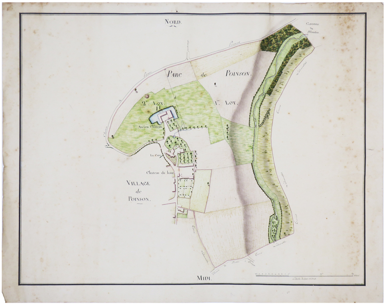
[ANONYME].
[HAUTE-MARNE] [Ensemble de trois plans de Poinson-lès-Grancey].
[début du XIXe siècle]. 43 x 55 cm chacune.
Bookseller reference : LBW-7456
|
|
|
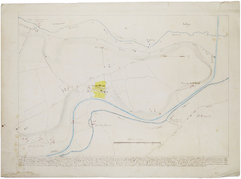
[ANONYME].
[HAUTE-MARNE] [Plan d'un canton contesté entre deux parties].
1783. 24 x 34 cm.
Bookseller reference : LBW-7462
|
|
|
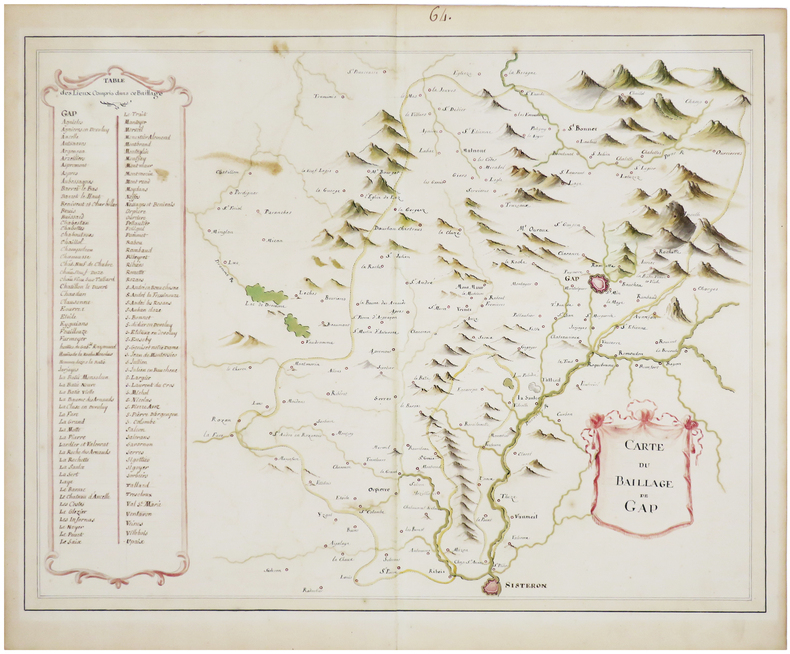
[ANONYME].
[HAUTES-ALPES] Carte du baillage de Gap.
[fin du XVIIIe siècle]. 38 x 49 cm.
Bookseller reference : LBW-7470
|
|
|
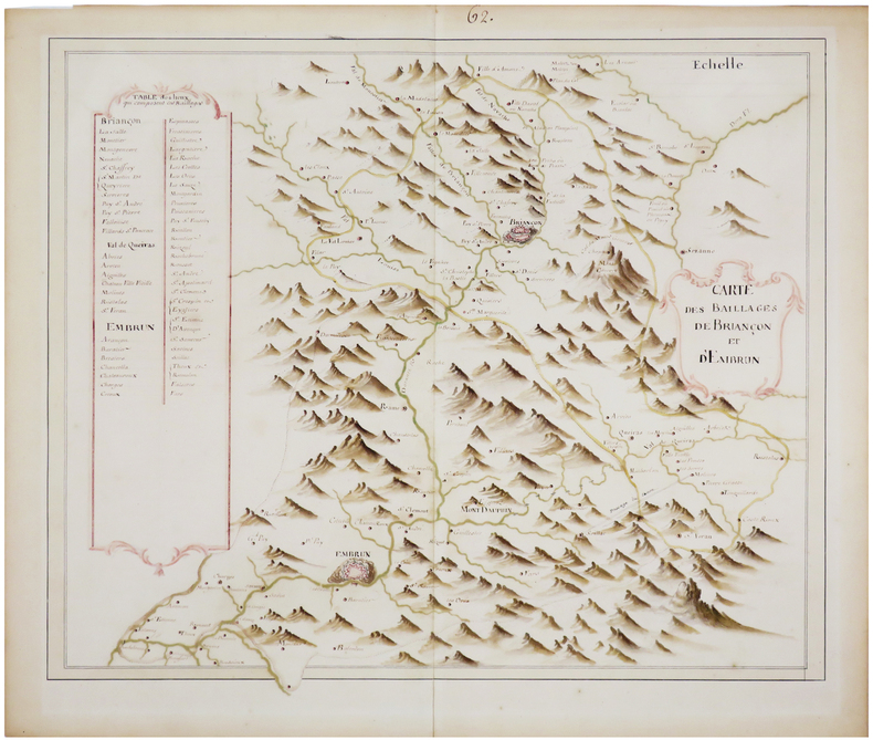
[ANONYME].
[HAUTES-ALPES] Carte des baillages de Briançon et d'Embrun.
[fin du XVIIIe siècle]. 37 x 45,5 cm.
Bookseller reference : LBW-7471
|
|
|
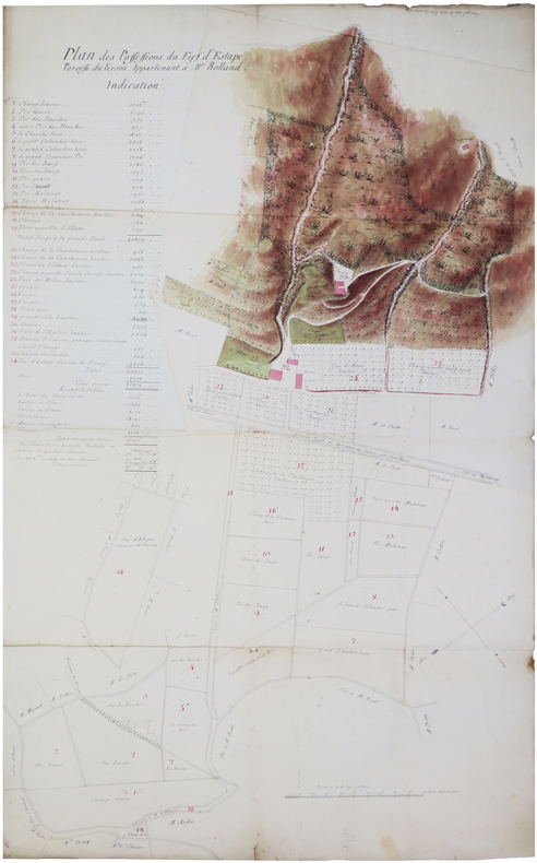
[ANONYME].
[ISÈRE] Plan des possessions du fief d'Estape, paroisse du Versou, appartenant à M.r Rolland.
[XVIIIe siècle]. En 3 feuilles jointes de 58,5 x 96 cm.
Bookseller reference : LBW-7458
|
|
|
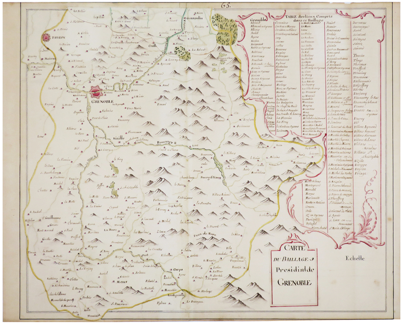
[ANONYME].
[ISÈRE] Carte du baillage présidial de Grenoble.
[fin du XVIIIe siècle]. 41 x 49 cm, plus une partie mobile de 7 x 20 cm repliée en haut de la carte.
Bookseller reference : LBW-7468
|
|
|
[ANONYME].
[LIMOUSIN] [Carte d'une partie du cours de la Vienne].
[vers 1700]. 28,5 x 39,6 cm.
Bookseller reference : LBW-7436

|
|
|
[ANONYME].
[LOT-et-GARONNE] [Carte du canton de Casteljaloux].
[début du XIXe siècle]. 16 x 33,5 cm pour les plus grandes dimensions de cette carte au format irrégulier.
Bookseller reference : LBW-7466

|
|
|
[ANONYME].
[LONDRES] London - Londra - Londres - Lóndres.
[vers 1900]. 330 x 423 mm, marges comprises.
Bookseller reference : LBW-8921

|
|
|
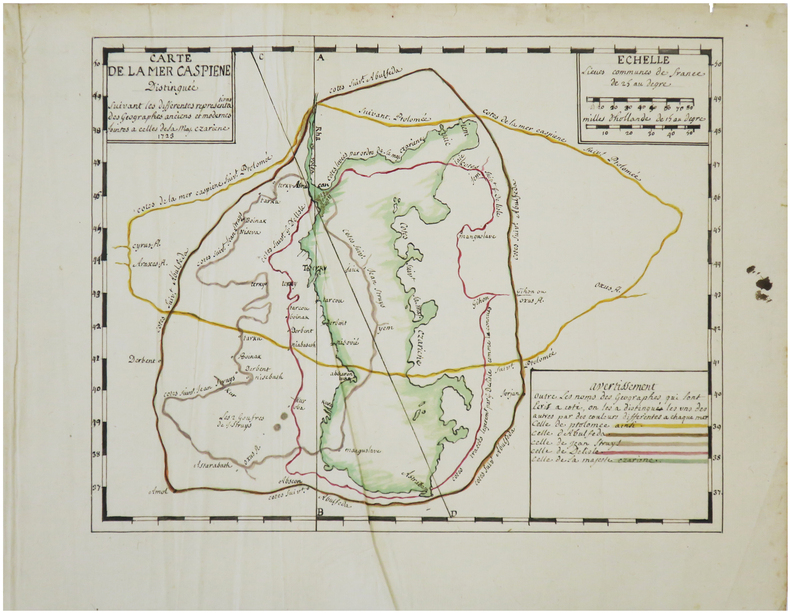
[ANONYME].
[MER CASPIENNE] Carte de la mer Caspiene, distinguée suivant les différentes représentations des géographes anciens et modernes jointes à celle de Sa Maj. czariene.
1723. 23 x 29 cm.
Bookseller reference : LBW-7453
|
|
|
[ANONYME].
[OISE] Plan d'une partie du terroir de Tracy, vers Attichy.
1770. 42,5 x 59 cm.
Bookseller reference : LBW-7447

|
|
|
[ANONYME].
[Partie de Brinon, Grandvau, les Réaux].
[fin du XVIIIe siècle]. 53,5 x 87 cm, sur une feuille de 63 x 94 cm.
Bookseller reference : LBW-6633

|
|
|
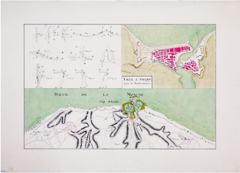
[ANONYME].
[Plan de Dieppe et du cap d'Antifer].
[vers 1780]. 22 x 33,7 cm.
Bookseller reference : LBW-6563
|
|
 Receive by email
 Download as PDF document
 RSS feed


