|
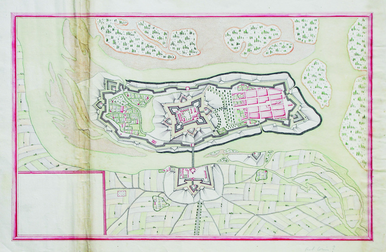
[ANONYME].
[Plan de Fort-Louis].
[milieu du XVIIIe siècle]. 28,5 x 43 cm sur une feuille de 33 x 47 cm.
Bookseller reference : LBW-6593
|
|
|
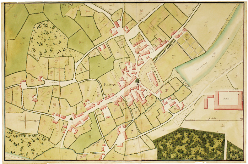
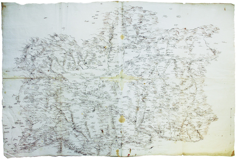
[ANONYME].
[Plan géométral de Brinon].
[fin du XVIIIe siècle]. 61 x 93 cm, sur une feuille de 63 x 95,5 cm.
Bookseller reference : LBW-6632
|
|
|
[ANONYME].
[PUY-de-DÔME] Carte de la généralité de Riom servant à l'indication des lieux pour le passage des troupes marchant par étape.
[fin du XVIIIe siècle]. 43 x 33 cm.
Bookseller reference : LBW-7439

|
|
|
[ANONYME].
[SAÔNE-et-LOIRE] Carte de l'arrondissement de Chalon.
[vers 1850]. En 18 sections montées sur toile et repliées, formant une carte de 69 x 102,5 cm ; sous étui de papier marbré bordeaux, étiquette de titre de papier vert.
Bookseller reference : LBW-7450

|
|
|
[ANONYME].
[SAINT-JEAN-d'ANGÉLY] St Jean d'Angeli.
[XVIIe siècle]. 278 x 360 mm, monté sur une feuille de 488 x 739 mm (montage ancien).
Bookseller reference : LBW-8709

|
|
|
[ANONYME].
[STOCKHOLM] Stockholm - Stocolma - Stockolm - Estocolmo.
[vers 1900]. 329 x 422 mm, marges comprises.
Bookseller reference : LBW-8937

|
|
|
[ANONYME].
[TARN] Plan des possessions dépendantes de la mettairie d'en Darassou sittuée au lieu de Flamarens, commune de Lavaur.
[vers 1790]. 48 x 75 cm sur deux feuilles jointes.
Bookseller reference : LBW-7443

|
|
|
[ANONYME].
[VAUCLUSE] Carte itinéraire du département de Vaucluse où sont désignées les barrières établies sur les routes de ce département.
[vers 1790]. 62 x 62,5 cm.
Bookseller reference : LBW-7464

|
|
|
[ANONYME].
[Vue des Bains de la Samaritaine].
[circa 1850]. 244 x 375 mm ; monté sur passe-partout (seuls les deux coins supérieurs sont fixés).
Bookseller reference : LBW-8931

|
|
|
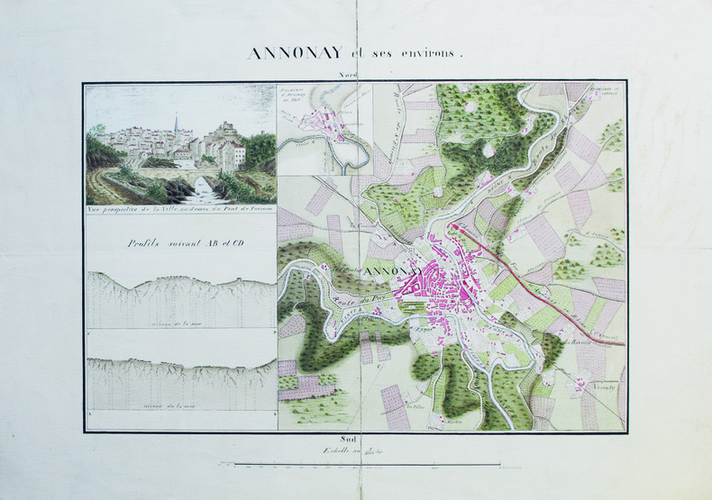
[ANONYME].
Annonay et ses environs.
[vers 1870]. 27 x 41 cm, sur deux feuilles jointes de 40 x 55 cm.
Bookseller reference : LBW-6585
|
|
|
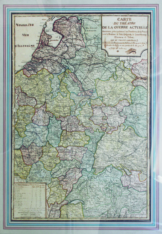
[ANONYME].
Carte du théâtre de la guerre actuelle.
1793. 65 x 46 cm ; encadrement de bois doré moderne.
Bookseller reference : LBW-6575
|
|
|
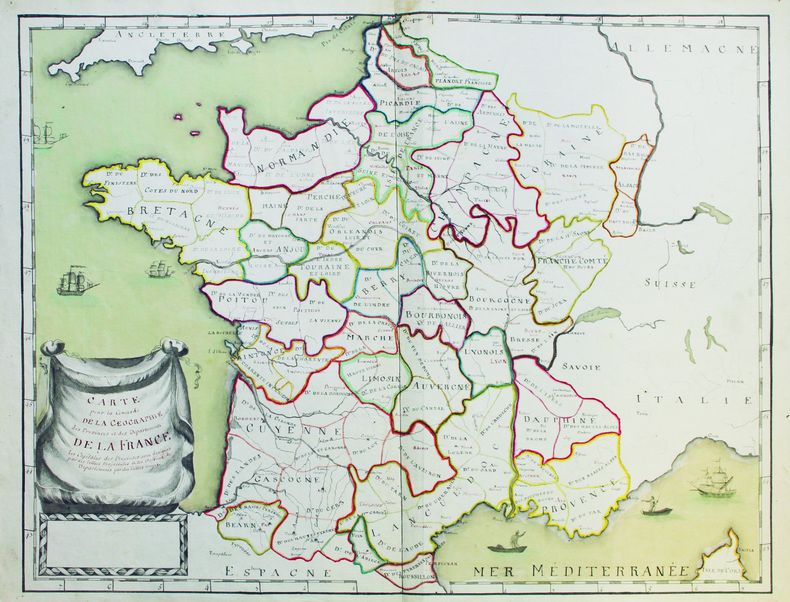
[ANONYME].
Carte pour la concorde de la géographie des provinces et des départements de la France.
[vers 1792-1793]. 48,5 x 61,5 cm, sur une feuille de 51,2 x 66,5 cm.
Bookseller reference : LBW-6579
|
|
|
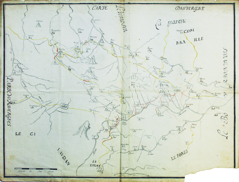
[ANONYME].
Carte d'Auvergne.
[XVIIIe siècle]. 50,5 x 64 cm, sur une feuille de 53 x 66,5 cm.
Bookseller reference : LBW-6583
|
|
|
[ANONYME].
Carte particullière des duchez de Mantoue, Millan, Parme, Plaizance, Gennes et Piedmont.
[circa 1630]. En quatre feuilles jointes formant une carte de 434 x 645 mm.
Bookseller reference : LBW-8949

|
|
|
[ANGERS] CASSINI
Carte générale de la France. [Angers]. N°98. Flle 100 / [établie sous la direction de César-François Cassini de Thury]
Paris 1767 carte d'époque entoilée sur une toile bleue repliée format 30,5 x 23 cm, format déplié : 60 x 92,5 cm, gravée en noir, [Paris] : [s.n.], 1767-1771
Bookseller reference : 21326
|
|
|
[ANGERS] CASSINI
Carte générale de la France. [Angers]. N°98. Flle 100 / [établie sous la direction de César-François Cassini de Thury]
Angers 1767 une carte d'époque, entoilée sur une toile marron repliée format 20 x 13,3 cm, format déplié : 59 x 92,5 cm, gravée en noir, [Paris] : [s.n.], 1767-1771, vendue chez Forest, Imprimeur-Libraire Nantes,
Bookseller reference : 23546
|
|
|
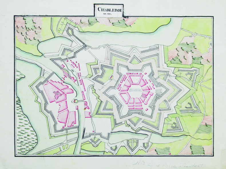
[ANONYME].
Charleroi.
An 1813. 23,5 x 30 cm, sur une feuille de 26,7 x 35 cm.
Bookseller reference : LBW-6602
|
|
|
[ANONYME].
Champigni, Moulin Neuf, et terres de Gros Bois.
[fin du XVIIIe siècle]. En deux feuilles pouvant être jointes pour former une carte de 91 x 87,7 cm.
Bookseller reference : LBW-6634

|
|
|
[ANONYME].
Dunkerque en Flandres.
[vers 1810]. 21 x 20 cm, sur une feuille de 24 x 23 cm.
Bookseller reference : LBW-6596

|
|
|
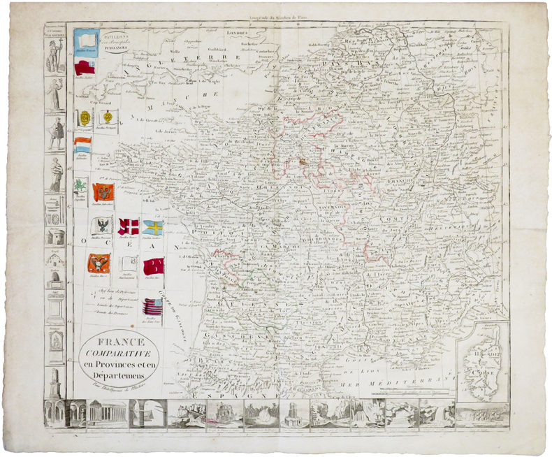
[ANONYME].
France comparative en provinces et en départemens. Pour l'intelligence de l'Histoire.
[circa 1790]. 372 x 411 mm.
Bookseller reference : LBW-6775
|
|
|
[ANONYME].
La Conquête du Pôle.
[circa 1905]. Chromolithographie de 345 x 439 mm, montée sur toile.
Bookseller reference : LBW-8027

|
|
|
[ANONYME].
Les Montaux et Doisne.
[fin du XVIIIe siècle]. 53,5 x 87 cm, sur une feuille de 62,5 x 95,5 cm.
Bookseller reference : LBW-6568
|
|
|
[ANONYME].
Lionnois Forez.
[vers 1700]. 58 x 86 cm, sur 2 feuilles jointes.
Bookseller reference : LBW-6582
|
|
|
[ANONYME].
Nouveau plan d'Orléans augmenté de ses faubourgs.
[vers 1810]. 20,5 x 27 cm, sur une feuille de 25 x 31 cm.
Bookseller reference : LBW-6591

|
|
|
[ANONYME].
Orléanais.
[milieu du XIXe siècle]. 45,3 x 60,5 cm ; monté sur carton et sous passe-partout.
Bookseller reference : LBW-7428

|
|
|
[ANONYME].
Pareis vom Konig Navarro belegert, und entsatz durch den Princz von Parma. Anno domini 1590 19 Augusti.
1590?. 210 x 276 mm.
Bookseller reference : LBW-6515

|
|
|
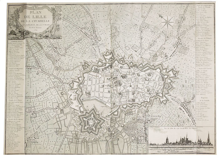
[ANONYME].
Plan de Lille de la citadelle et banlieue de la ville et de ses environs.
1784. 550 x 765 mm.
Bookseller reference : LBW-766
|
|
|
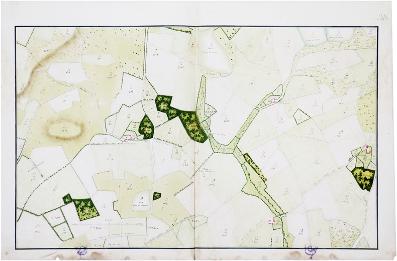
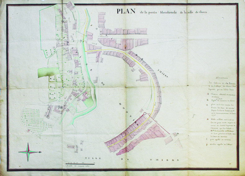
[ANONYME].
Plan de la partie méridionale de la ville de Thiers.
[vers 1780]. 53 x 70,5 cm.
Bookseller reference : LBW-6561
|
|
|
[ANONYME].
Plan de la ville [d'Aigues-Mortes].
[vers 1880]. 39 x 56 cm.
Bookseller reference : LBW-6566
|
|
|
[ANONYME].
Plan d'une ville fortifiée dans le style de Vauban.
1764. 47 x 39 cm, encadré sous verre moderne.
Bookseller reference : LBW-6577

|
|
|
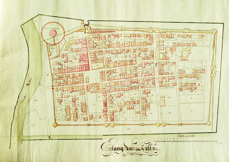
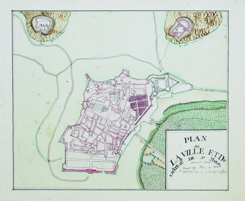
[ANONYME].
Plan de la ville et du château de St Malo.
1812. 24,5 x 29,5 cm, sur une feuille de 29,5 x 34,5 cm.
Bookseller reference : LBW-6589
|
|
|
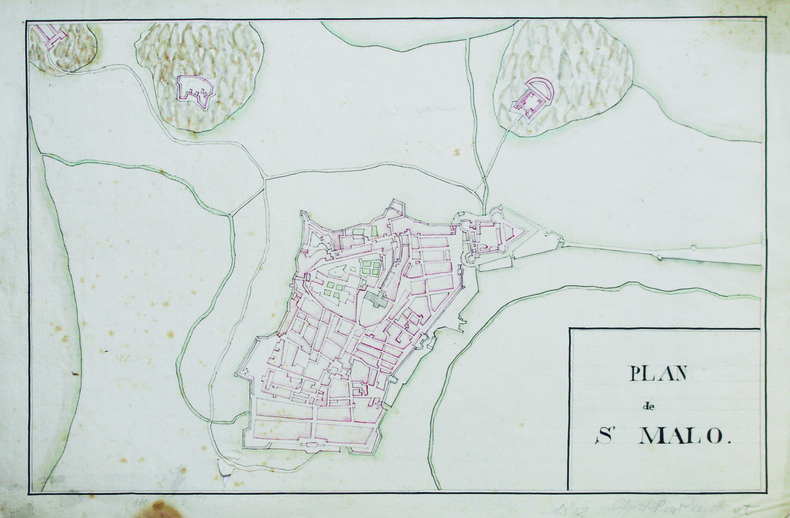
[ANONYME].
Plan de St Malo.
1813. 27 x 41 cm, sur une feuille de 30,5 x 46 cm.
Bookseller reference : LBW-6590
|
|
|
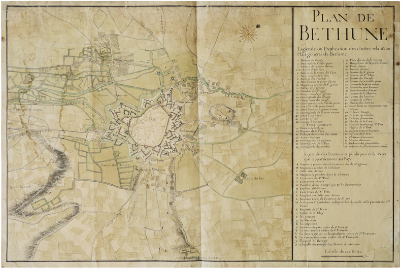
[ANONYME].
Plan de Béthune.
[milieu du XVIIIe siècle]. 51 x 76,5 cm, sur une feuille de 53,5 x 79 cm.
Bookseller reference : LBW-6595
|
|
|
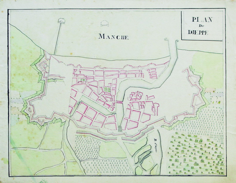
[ANONYME].
Plan de Dieppe.
[vers 1810]. 26,5 x 33,5 cm, sur une feuille de 30,5 x 37,8 cm.
Bookseller reference : LBW-6599
|
|
|
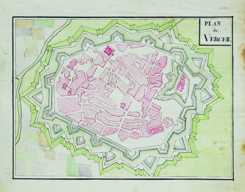
[ANONYME].
Plan de Verceil.
[vers 1810]. 16,5 x 22,5 cm, sur une feuille de 21,5 x 25,6 cm.
Bookseller reference : LBW-6605
|
|
|
[ANONYME].
Plan de la ferme de la Soupelière appartenant à M. le baron M.J.A. Pron.
[vers 1865]. En 18 sections montées sur toile et pliées, de 58 x 91 cm.
Bookseller reference : LBW-6631

|
|
|
[ANONYME].
Plan d'aménagement d'un jardin en terrasse.
[fin du XIXe siècle]. 35,5 x 44 cm.
Bookseller reference : LBW-7449

|
|
|
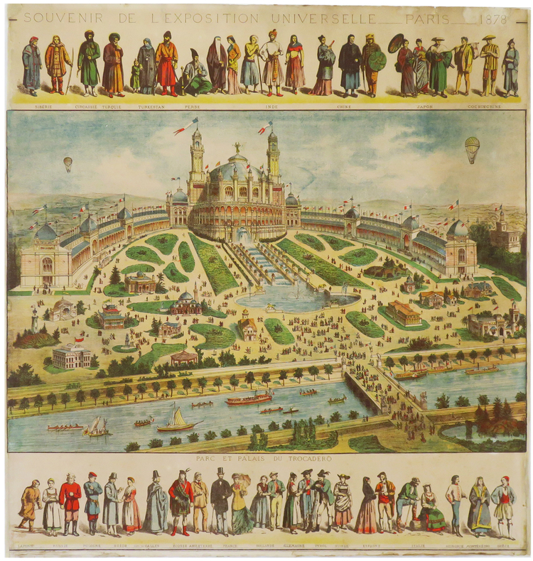
[ANONYME].
Souvenir de l'Exposition Universelle. Paris. 1878.
1878. 593 x 573 mm.
Bookseller reference : LBW-6860
|
|
|
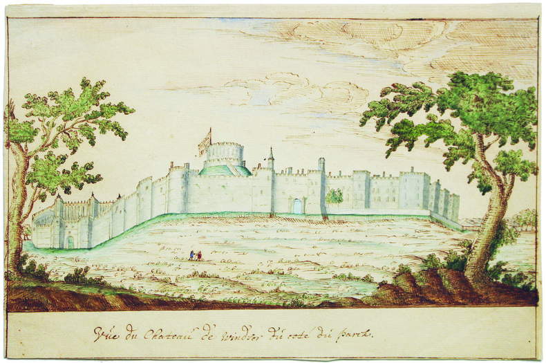
[ANONYME].
Vue du château de Windsor du côté du parck.
[XVIIIe siècle]. 14,5 x 22,5 cm, sur une feuille pliée en deux de 22,7 x 30,7 cm.
Bookseller reference : LBW-6609
|
|
|
[ANONYME].
Vues de Paris. Notre-Dame de Paris.
Paris, Gosselin, et Lyon, Gadola, [circa 1865]. 240 x 306 mm.
Bookseller reference : LBW-8853

|
|
|
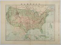
[ANACHRONISTIC MAP OF THE UNITED STATES INCLUDING CUBA AS A TERRITORY].
北米合衆国全図. Hokubei Gasshūkoku zenzu. Map of the United States of America.
Tokyo.: 楠山正雄. Kusuyama Masao. Meiji 44 1911. Colour folding map 40 x 55cm inset maps showing the Philippines Alaska and Hawaii very good copy. This map was a supplement of October 1911 issue of a monthly magazine Shin Nippon 新日本 which was published between 1911 and 1918. The main map covers the contiguous United States with inset maps of the world showing the American territories of Alaska Hawaii and the Philippines. Curiously Cuba has been marked as an American territory having been directly occupied from 1906 to 1909 though at the time still beholden to the 1903 Cuban-American Treaty of Relations. . 楠山正雄. [Kusuyama Masao]. unknown
Bookseller reference : 179415
|
|
|
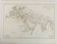
[ANCIENT WORLD - ANTIQUE MAP] (MALTE-BRUN, CONRAD), POIRSON, JEAN BAPTISTE; TARDIEU (AMBROISE).
Monde comm des Anciens.
Paris. circa1820. Engraved map with original outline hand-colour 21.1 x 31.5cm original folds a few spots and a little creased but in very good condition. Latin map of the Ancient world encompassing Europe India Arabia the Middle East and North Africa by the French cartographer Jean Baptiste Poirson 1761-1831 finely engraved. . unknown
Bookseller reference : 177230
|
|
|
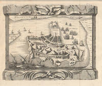
[ANTIQUE MAP -- HORMUZ ISLAND. IRAN] (BELLIN, JACQUES NICOLAS & JAKOB VAN DER SCHLEY).
Das Eyland Ormus oder Jerun.
Leipzig. circa1747. Engraved map on laid paper in original uncoloured state 19 x 24 cm; 25.1 x 30.3 cm sheet original folds a trifle spotted and browning to one of the folds but in good condition. Fine map of the Iranian island of Hormuz in the Persian Gulf by Jacques Nicolas Bellin published in Prevost's "Histoire generale des Voyages .". Traditional Persian vessels can be seen bobbing in the foreground and numbers of merchant vessels to the East illustrating the strategic importance of the Strait of Hormuz and the competition for access to trading routes. Sites of fresh water are noted and the Portuguese fortress to the north of the island is delineated. A beautiful map. . unknown
Bookseller reference : 177131
|
|
|
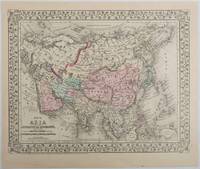
[ANTIQUE MAPS - ASIA AND CENTRAL ASIA] MITCHELL JR., S. AUGUSTUS
Map of Asia Showing its Gt. Political Divisions and also the Various Routes of Travel Between London & India China & Japan &c. with Map of Persia Arabia Turkey in Asia Afghanistan Beloochistan.
Pennsylvania. 1879. Lithographed maps on two sides of a single leaf with original hand-colouring 27 x 34 cms map size 31.1 x 37.1 cms sheet with a finely-engraved foliated border margins age-toned one margin tide-marked at the edge not affecting the maps a handsome pair of maps in very good condition. A most attractive pair of late 19th Century maps on two sides of a single leaf: Asia as a whole polar projection with Europe and parts of Africa and New Guinea. Scale 1:1000 miles. It includes steamship routes and mileages from London to destinations in Asia: Zhoushan Chusan Island Hong Kong Manilla Sarawak Bombay etc. along with political and geographical details; and on the verso the map covers the regions of Persia Iran Arabia including parts of the Arabian Peninsula Turkey in Asia Anatolia Afghanistan and Beloochistan parts of Iran Afghanistan and Pakistan and marks key settlements rivers and geographic features. . unknown
Bookseller reference : 221209
|
|
|
[ANTIQUE MAPS - GERMANY. ORTELIUS, ABRAHAM]
Thietmarsiae Holsaticae Regionis Partis Typus. Auictore Petro Boeckel with Rugiae Usedomiae et Iulinae Wandalicarum Insularum Vera Descriptio. Image of Dittmarschen a part of Holstein by Petrus Boeckel with A true image of Rügen and Iulinia Islands of Wandalica. 1584.
Antwerp.: Abraham Ortelius. circa1584. Two engraved maps on laid paper each 30.3 x 19.5 cm printed on the one sheet 48 x 60 cm original fold attractive hand colour with related French text on verso slight toning and spotting to the margins but the maps in very good condition preserved in a modern window mount. Attractive maps of the German coast published in Ortelius' great atlas "Theatrum Orbis.". The left-hand map showing the mouths of the Elbe complete with sea monster and Eider Rivers and the coast of Schleswig-Holstein; the right-hand map of the Baltic coast with the Pomeranian islands of Rugen and Usedom. . (Abraham Ortelius). unknown
Bookseller reference : 64215

|
|
|
[ANTIQUE WORLD MAP] (SMITH, ROSWELL CHAMBERLAIN), O. PELTON (ENGRAVER).
A Chart Exhibiting the Actual and Comparative Size of Each Country Nation or Kingdom; its Population as a Whole and to a Square Mile: Also the Different States of Society Forms of Government Religion &c.
Philadelphia.: W. Marshall. Circa1835. Handcoloured engraved map 26.5 x 41.3 cms; 29.6 x 48.3 cms sheet central fold insets of "Oceanica" and "New Holland" central table some light staining in the image and margins in good condition. Eurocentrism laid bare. This 19th Century map includes a "State of Society" for each part of the world declared with a symbol to represent "Barbarous Half Civilized Civilized and Enlightened Societies" as well as noting religion and ethnicity. It includes a table of distances between chief towns or capitals and between these towns and Washington DC. Australia "New Holland" is styled principally as pagan barbarous unexplored and African a thin sliver of what is now New South Wales and Victoria is labelled civilized European and Protestant. Scarce. . (W. Marshall). unknown
Bookseller reference : 203763
|
|
|
[Arabian Peninsula].
Omoumi Mamalik Mahrousi Shahani [General map of the protected countries. Ottoman Empire]. Istanbul, Matbaa-i Amire [Imperial Military Press], [1896 CE =] 1312 H.
150 x 130 cm. Scale: 1:3,000,000. Colour lithograph, dissected into 24 sections and mounted on original linen. Very rare, monumental wall map of the Ottoman Empire, featuring one of the largest and most detailed printed representations of the Arabian Peninsula produced in the Islamic World prior to World War I. Perhaps more than any other map, it reveals the immense logistic challenges faced by Hajj pilgrims just in advance of the construction of the Baghdad and Hejaz Railway systems. Printed for official use, the map appeared at a time when the Sublime Porte was going to great lengths to shore up its authority in the Red Sea region (Hejaz, Asir, and Yemen), while being pressured by Britain to retreat from the domains it claimed in the Arabian Gulf (Kuwait, Al-Qatif/Hofuf, and Qatar). - Indeed, the present map would have been of great value to Ottoman generals and cabinet officials for strategic planning, as Arabia was increasingly a focus of global attention and interference. It served as the ideal strategic aid to chart the future construction of the Hejaz Railway (built 1900-08) and the Baghdad Railway (extended from the Anatolian Railway, from 1903 onwards) and delineates some of the world's most strategically important railway lines before 1900. - The main map encompasses most of the Arabian Peninsula, from Qatar and the Hadramaut westwards (while far eastern Arabia, including Oman and what is today the United Arab Emirates is featured in an inset, lower left). The coastlines and rivers are crisply depicted; mountain ranges are expressed by delicate tan shading; all cities and towns of note are labelled; the names of regions and tribal areas are revealed, while all key roads and Hajj caravan routes are delineated. The map features stellar coverage of the western Gulf region, labelling Qatar (then an autonomous part of the Ottoman Empire), Bahrain (a British protectorate prized for its fine natural harbour), and Kuwait, an autonomous Sheikhdom within the Ottoman Empire that would shortly become a British protectorate. Inland, the map details the Saudi-Wahhabi domain Nejd, with its capital Riyadh, while to the northwest lies the territory of the rival Al-Rashid clan, with its capital Ha’il. - Minor soiling and waterstaining, occasional light edge wear. Tears in linen partly repaired. A rare survival. Osmanli cografya literatürü tarihi [History of geographical literature during the Ottoman period], pp. 756f. David Rumsey Map Collection 13186.000 (the single other copy known in the trade). Not in Al-Qasimi collection (1493-1931).
|
|
|
[Aramco - Map of Saudi Arabia and the Gulf].
Central Area. Scale 1:1,000,000. [Dhahran, Aramco / USGS, 1953 or shortly after].
763 x 763 mm. Scale 1:1,000,000. Key in English. Printed on cloth. Blueprint map of the Gulf, showing Qatar, Bahrain, and Kuwait, as well as parts of Saudi Arabia, Iran and Iraq. It pays particular attention to oil fields, naming them individually and illustrating oil pipelines and facilities, including the 435 kilometre Qatif-Qaisumah pipeline which connects to the Trans-Arabian pipeline, as well as the offshore terminal and refinery at Ras Tanura. The map records some of the problematic borders within the region, showing the Iraq-Saudi Neutral Zone, the Kuwaiti-Saudi Neutral Zone and Buraimi Oasis. Among the more notable oil fields are Greater Burgan, the world's largest sandstone oil field, consisting of the Burgan field itself along with the much smaller Magwa and Ahmadi fields, as well as the Wafra field discovered in 1953 by the American Independent Oil Company and Pacific Western Oil Company. Wafra was unique in being operated jointly under separate concessions from two countries, Kuwait and Saudi Arabia, granted to American Independent Oil Company and Getty Oil Company (formerly Pacific Western Oil Company) respectively. - Slightly toned along folding lines and lower left margin.
|
|
|
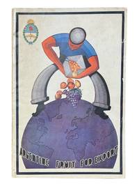
[Argentina] [Maps] Ministry of Agriculture
Argentine Fruit for Export January 1935
Buenos Aires: Argentine Republic Ministry of Agriculture Division of Control of Fruit Production 1935. First edition. 8vo 36pp plus fold out map at rear showing fruit producing zones of Argentina. In English with photos throughout. Illustrated wrappers with light chipping to edges. Clean internally and very good. <br /> <br /> Scarce and attractive Buenos Aires imprint with fold out map. OCLC cites 6 holdings. Argentine Republic, Ministry of Agriculture, Division of Control of Fruit Production unknown
Bookseller reference : 9159
|
|
|
[Armenia].
Arménie Russe. Rossijskaja Armenija. Venice, [Imprimerie des Méchitaristes de] St. Lazare, 1828.
260 x 380 mm. Engraved map mounted on cloth. Matted. Early map of Russian Armenia, featuring the eight provinces annexed by Russia in 1828, with key in French and Russian. Following Qajar Iran's defeat in the Russo-Persian War (1826-28) and the 1828 Treaty of Turkmenchay, Eastern Armenia was, among other territories, ceded to Russia. It would remain part of the Russian Empire until its collapse in 1917. - Printed at the Mechitarists' press on the island of San Lazzaro, Venice, where the Armenian order had set up their colony in 1717. They began their editorial activities as early as the following year and set up a printing press, famed for its typographic capability in many languages and alphabets, in 1789. - Very rare; catalogues list a single specimen in the British Library. OCLC 556404373.
|
|
 Receive by email
 Download as PDF document
 RSS feed


