|
Cunnersdorf:
Cunnersdorf bei Frankfurt an der Oder. "Plan der Bataille, welche d. 12.August 1759 von der Russisch Kayserlich und Königlich Preussischen Armee bey Cunnerstdorf ohnweit Frankfurt an der Oder geliefert worden." Schlachtenplan von Cunnersdorf, links mit Legende. Kupferstich mit farbigen Truppenaufstellungen aus "Neues Kriegs-Theater ..." No.24.
Format: 18 x 29,5 cm. *Leicht gebräunt, insgesamt gut erhalten. Landkarten de
|
|
|
Cunningham, John T.; maps, Homer Hill
New Jersey : America's main road
Garden City New York : Doubleday & Comapny 1966. 1966. Good. xx 326 ; illustrated ; beige and blue cloth no dustjacket ; ex-lib stamps label date due pocket ; Contents: Geology molder of destiny -- Before the white sails showed -- New Amsterdam and New Sweden -- The time of two Jerseys -- Power of the purse -- Portrait of 100 years -- Slow strides to independence -- Revolution's crossroads -- Founding a nation -- towpath and iron horse -- Invasion of skills -- Search for a conscience -- Northernmost of the border states -- The backbone turns iron -- Revolution at the crossroads -- Ideas money and muscles -- The huddled masses -- Victorian interlude -- Of the people -- The yanks are coming -- Safe for democracy -- Bullets babies and moving vans -- Where to find New Jersey. ; G Garden City, New York : Doubleday & Comapny, 1966. hardcover
Bookseller reference : 005766

|
|
|
CURATELE SABENA
Poster: Sabena: Service Impeccable
, Plaizier, 2025 Poster, 61 91 cm, Nieuw.
Bookseller reference : 69230
|
|
|
Curator: BESTE GÜRSU.
Beyoglu Belediyesi 155. Yil Beyoglu Bellegi Arsiv Sergisi. Efemera sergisi. 2-25 Agustos 2012. [Exhibition catalogue].
New English Paperback. Pbo. Large 8vo. (22 x 22 cm). In Turkish. [42] p. Color and b/w ills. Beyoglu Belediyesi 155. Yil Beyoglu Bellegi Arsiv Sergisi. Efemera sergisi. 2-25 Agustos 2012. [Exhibition catalogue].
|
|
|
Curator: BESTE GÜRSU.
Maps of Beyoglu.= Beyoglu haritalari. [Exhibition catalogue]. 04-15 December 2012.
New English Paperback. Pbo. Large 8vo. (21 x 21 cm). In English and Turkish. 42 p. Color and b/w ills. Beyoglu - Pera (Constantinople) from incunabulum to present day. Maps of Beyoglu.= Beyoglu haritalari. [Exhibition catalogue]. 04-15 December 2012.
|
|
|
CURRIER (Nathaniel) & IVES (James Merritt) & PALMER (Frances Flora Bond.
[MISSISSIPPI] The Champions of the Mississippi. "A Race for the Buckhorns".
New York, Currier & Ives, [1866]. 515 x 715 mm ; sur papier fort.
Bookseller reference : LBW-8672

|
|
|
CURRIER (Nathaniel) & IVES (James Merritt).
[MISSISSIPPI] The Great Race on the Mississippi from New Orleans to St. Louis 1210 miles, between the steamers Robt. E. Lee, Capt. J.W. Cannon and Natchez, Capt. T.P. Leathers. Won by the R.E. Lee, time: 3 days 18 hours 30 minutes.
New York, Currier & Ives, [1870]. 543 x 740 mm ; sur papier fort.
Bookseller reference : LBW-8700

|
|
|
Curtis, William
ORIGINAL HAND-COLOURED ENGRAVING - Ilex chinensis FROM CURTIS'S BOTANICAL MAGAZINE - Plate No. 2043 dated 1819
W. Curtis 1819. Print. Very Good. Unframed. First Edition. A fine original hand-coloured copper-engraved plate from this famous work size approx. 14 x 24cm. The condition is very good colours bright and fresh paper bright minimal offsetting supplied without accompanying text and without mount. The quality of the illustrations in the Botanical Magazine is outstanding both accurate and decorative the colours vibrant. William Curtis 1746-1799 was a trained apothecary living in London although his passion was for natural history particularly plants and insects. He maintained a large well-stocked garden and began the publication of the Botanical Magazine in February 1787 which has gone on to become the most famous and influential botanical publication of its type; it is still published today making it the longest running scientific periodical of all time. Curtis edited the first 13 volumes and was then succeeded by John Simms 1800-1826 William Jackson Hooker 1827-1865 and Joseph Dalton Hooker 1865-1904 the current editor of the magazine is Martyn Rix. The fine illustrations were by many artists including Sydenham Edwards William Graves James Sowerby John Curtis William Jackson Hooker W.H. Fitch J. N. Fitch Matilda Smith Lillian Snelling and Stella Rose Craig. The plates were hand-coloured up to 1948! all being copper engravings to around 1840 and then stone or zinc lithography until the introduction of color printing in 1948. References: Blunt;The Art of Botanical Illustration Great Flower Books pp. 156 - 157 Nissen BPI 2350 Staflue 1290. Please Note: we do not break books for plates nor do we condone this practice. Our plates have either been purchased loose or have come from books that are so defective or incomplete that they are irreparable. W. Curtis unknown
Bookseller reference : 020307

|
|
|
Cusset Catherine Robet Alain
Le côté gauche de la plage
EDTS DIALOGUES 2015 71 pages 15 8x1x15 8cm. 2015. Broché. 71 pages.
Bookseller reference : 100149789
|
|
|
CUSSON L.
Nouveau plan de la ville de La-Roche-sur-Yon. Plan rural au verso.
Une feuille 55x78 cm en pochette.
|
|
|
Cycle Maps UK
Central Scotland Cycle Map 21
Sheet map folded. New. unknown
Bookseller reference : A9781904207726 ISBN : 1904207723 9781904207726

|
|
|
Cycle Maps UK
Cornwall & West Devon Cycle Map 1 Cycle Maps UK
Cycle Maps UK 2022. Map. New. 1 pages. 6.34x3.98x0.51 inches. Cycle Maps UK unknown
Bookseller reference : 2-190420774X ISBN : 190420774X 9781904207740
|
|
|
Cycle Maps UK
Cornwall & South Devon Cycle Map 1
Sheet map folded. New. unknown
Bookseller reference : A9781904207740 ISBN : 190420774x 9781904207740

|
|
|
Cycle Maps UK
East Anglia Cycle Map 13
like new. unknown
Bookseller reference : 47094832 ISBN : 1904207812 9781904207818
|
|
|
Cycle Maps UK
East Anglia Cycle Map 13
new. unknown
Bookseller reference : 47094832-n ISBN : 1904207812 9781904207818
|
|
|
Cycle Maps UK
East Anglia Cycle Map 13
Cycle Maps UK 2023. Unknown Binding. New. 1st ed september 2023 edition. 2 pages. 8.27x5.91x0.79 inches. Cycle Maps UK unknown
Bookseller reference : __1904207812 ISBN : 1904207812 9781904207818
|
|
|
Cycle Maps UK
Edinburgh and Central Southern Scotland Cycle Map 24 Cycle Maps UK
like new. unknown
Bookseller reference : 44619597 ISBN : 1904207723 9781904207726
|
|
|
Cycle Maps UK
Edinburgh and Central Southern Scotland Cycle Map 24 Cycle Maps UK
new. unknown
Bookseller reference : 44619597-n ISBN : 1904207723 9781904207726
|
|
|
Cycle Maps UK
Edinburgh & Central Southern Scotland Cycle Map 24
Sheet map folded. New. New Book; Fast Shipping from UK; Not signed; Not First Edition; The next map in the Cycle Maps UK series covers the city of Edinburgh and the area to the south. unknown
Bookseller reference : ria9781904207726_inp ISBN : 1904207723 9781904207726

|
|
|
Cycle Maps UK
Edinburgh and Central Southern Scotland Cycle Map 24 Cycle Maps UK
Cycle Maps UK 2022. Map. New. 2 pages. 6.34x3.98x0.51 inches. Cycle Maps UK unknown
Bookseller reference : 2-1904207723 ISBN : 1904207723 9781904207726
|
|
|
Cycle Maps UK
Edinburgh and Central Southern Scotland Cycle Map 24 Cycle Maps UK
Cycle Maps UK 2022. Map. New. 2 pages. 6.34x3.98x0.51 inches. Cycle Maps UK unknown
Bookseller reference : __1904207723 ISBN : 1904207723 9781904207726
|
|
|
Cycle Maps UK
Lake District & Cumbria Cycle Map 22 Cycle Maps UK
new. unknown
Bookseller reference : 44619598-n ISBN : 1904207715 9781904207719
|
|
|
Cycle Maps UK
Lake District & Cumbria Cycle Map 22 Cycle Maps UK
like new. unknown
Bookseller reference : 44619598 ISBN : 1904207715 9781904207719
|
|
|
Cycle Maps UK
Lake District & Cumbria Cycle Map 22
Sheet map folded. New. New Book; Fast Shipping from UK; Not signed; Not First Edition; The maps are all produced at a scale of 1:100 000 showing important features including the National cycle Network. Sections on road off road and traffic free are all shown in differing colours along with their route number. unknown
Bookseller reference : ria9781904207719_inp ISBN : 1904207715 9781904207719

|
|
|
Cycle Maps UK
Lake District & Cumbria Cycle Map 22 Cycle Maps UK
Cycle Maps UK 2022. Map. New. 2 pages. 6.38x3.98x0.55 inches. Cycle Maps UK unknown
Bookseller reference : 2-1904207715 ISBN : 1904207715 9781904207719
|
|
|
Cycle Maps UK
Lake District & Lancashire Cycle Map 15
Sheet map folded. New. unknown
Bookseller reference : A9781904207719 ISBN : 1904207715 9781904207719

|
|
|
Cycle Maps UK
Lake District & Cumbria Cycle Map 22 Cycle Maps UK
Cycle Maps UK 2022. Map. New. 2 pages. 6.38x3.98x0.55 inches. Cycle Maps UK unknown
Bookseller reference : __1904207715 ISBN : 1904207715 9781904207719
|
|
|
Cycle Maps UK
London and Essex Cycle Map 6 Cycle Maps UK
Cycle Maps UK 2022. Map. New. 1 pages. 6.38x3.98x0.67 inches. Cycle Maps UK unknown
Bookseller reference : 2-1904207758 ISBN : 1904207758 9781904207757
|
|
|
Cycle Maps UK
London and Essex Cycle Map 6 Cycle Maps UK
Cycle Maps UK 2022. Map. New. 1 pages. 6.38x3.98x0.67 inches. Cycle Maps UK unknown
Bookseller reference : __1904207758 ISBN : 1904207758 9781904207757
|
|
|
Cycle Maps UK
London and Essex Cycle Map 7
Sheet map folded. New. unknown
Bookseller reference : A9781904207757 ISBN : 1904207758 9781904207757

|
|
|
Cycle Maps UK
Peak District Cycle Map 18 Cycle Maps UK
new. unknown
Bookseller reference : 44619596-n ISBN : 1904207731 9781904207733
|
|
|
Cycle Maps UK
Peak District Cycle Map 18 Cycle Maps UK
like new. unknown
Bookseller reference : 44619596 ISBN : 1904207731 9781904207733
|
|
|
Cycle Maps UK
Peak District Cycle Map 18
Sheet map folded. New. New Book; Fast Shipping from UK; Not signed; Not First Edition; The maps are all produced at a scale of 1:100 000 showing important features including the National cycle Network. Sections on road off road and traffic free are all shown in differing colours along with their route number. unknown
Bookseller reference : ria9781904207733_inp ISBN : 1904207731 9781904207733

|
|
|
Cycle Maps UK
Peak District Cycle Map 18 Cycle Maps UK
Cycle Maps UK 2022. Map. New. 2 pages. 6.42x3.94x0.63 inches. Cycle Maps UK unknown
Bookseller reference : 2-1904207731 ISBN : 1904207731 9781904207733
|
|
|
Cycle Maps UK
Peak District & Lincolnshire Cycle Map 14
Sheet map folded. New. unknown
Bookseller reference : A9781904207733 ISBN : 1904207731 9781904207733

|
|
|
Cycle Maps UK
Peak District Cycle Map 18 Cycle Maps UK
Cycle Maps UK 2022. Map. New. 2 pages. 6.42x3.94x0.63 inches. Cycle Maps UK unknown
Bookseller reference : __1904207731 ISBN : 1904207731 9781904207733
|
|
|
CYCLING & MOTORING MAP OF EXETER DISTRICT
Bacon's Cycling and Motoring Map of Exeter District[Cycling and Touring] Map of 60 Miles South of London, including Worthing, Brighton, Hastings, etc.. Scale Half an Inch to One Mile. NEAR FINE COPY
8vo., folding map on cloth, coloured in outline, measuring 15 x 20 inches (approx. 38 x 51 cms) folding in 18 panels to 5.25 x 3.5 inches (approx. 13 x 9 cms); red limp cloth wrappers lettered in black, radial corners, a near fine copy. With trade advertisements. SCARCE IN THIS CONDITION.
|
|
|
Cyprus Tourism Organisation
A Visitor's Map of Cyprus
Large fold-out map. Scale 1: 350000.[40 x 63 cm; folded to 11 x 23 CM.] Map
|
|
|
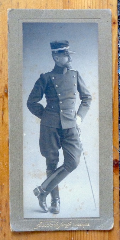
Cérenville B. de :
Portrait photographique en pied.
Lausanne, Francis de Jongh, [1914]. Photographie au format 8 x 17 cm., nom du photographe doré au bord inférieur. Légèrement frottée, avec quelques rousseurs.
Bookseller reference : 8157
|
|
|
Cüstrin:
Cüstrin. "Plan der Belagerung der Stadt und Vestung Cüstrin durch die Kaiserl. Russische Armee im Monath August An.1758." Stadtplan von Cüstrin. Kupferstich mit farbigen Truppenaufstellungen. Aus "Neues Kriegs-Theater", Supplement No. 4.
Format: 18 x 29,5 cm. *Leicht gebräunt, insgesamt gut erhalten. Landkarten de
|
|
|
D'Allemagne Henri René
Les Cartes A Jouer du Quatorzième Au Vingtième Siècle
Hachette Et Cie Editeur - Paris - 1906 - Edition Originale - Deux gros volumes épais- Complet - Volume 1 :504 pages, volume 2 :640 pages .Exceptionnel ouvrage contenant 3200 reproductions de cartes à jouer ,956 en couleurs,12 planches hors texte acquaréllées main ,25 phototypies,116 enveloppes de cartes à jouer ,340 vignettes et vues diverses, tables des matières complètes en fin de chaque volume - Serpentes protégeant bien les gravures - Volumes in folio non rogné demi veau rouge ,dos à nerfs ,couvertures conservées ,intérieur très frais,pas de rousseur .
Bookseller reference : 9812

|
|
|
D'ANVILLE
L'Europe.
Géographie Ancienne, Abrégée. Avec les Cartes Géographiques nécessaires pour faciliter l'intélligence. Tome 1er seul: Contenant L'Europe. 1 frontispice par Gravelot et Simonet et 6 cartes repliées. Paris, Chez P. Théophile Barrois, Jeune, Libraire, 1782. In-12 (17x10cm) plein veau raciné d'époque, dos lisse orné de motifs et tomaison dorés, tranches rouges, petite fente sur la charnière supérieure, coins émoussés. XXIV,341pp.+ 1ff errata.
Bookseller reference : WOC-2454

|
|
|
D'Anville Jean Baptiste Bourguignon (1697-1782)
Plan de Rome Ancienne Dressé pour L'intilligence de l'histoire Romaine de Mr. Rollin
Pianta di Roma antica disegnata da Jean-Baptiste Bourguignon D'anville per la Storia romana del Rollin. Histoire romaine depuis la fondation de Rome jusqu'à la bataille d'Actium di Charles Rollin divenne una tra le opere più durature dedicate alla storia romana, impreziosita da alcune carte geografiche inserite nell'Atlas de géographie ancienne pour servir à l'intelligence des oeuvres de Rollin: gravé d'après les cartes originales de d'Anville. Incisione in rame, consuete pieghe di carta, in ottimo stato di conservazione. Pianta di Roma antica disegnata da Jean-Baptiste Bourguignon D'anville per la Storia romana del Rollin. Histoire romaine depuis la fondation de Rome jusqu'à la bataille d'Actium di Charles Rollin divenne una tra le opere più durature dedicate alla storia romana, impreziosita da alcune carte geografiche inserite nell'Atlas de géographie ancienne pour servir à l'intelligence des oeuvres de Rollin: gravé d'après les cartes originales de d'Anville. Incisione in rame, consuete pieghe di carta, in ottimo stato di conservazione.

|
|
|
D'Anville, [Jean-Baptiste Bourgignon].
Golfe Persique. Dressé en 1758 et publié en 76 par le Sr. d'Anville, Prém[ier] Géogr[aphe] du Roi. [Paris], 1776.
Engraved map. 282 x 440 mm (image). 311 x 465 mm (sheet). The famous nautical chart by the French geographer and cartographer d'Anville (1697-1782), encompassing the Arabian Gulf from Basra to the Straits of Hormuz. Although the southwestern part of the Gulf is poorly explored, various Gulf cities are identified, including "Julfar" (Ras al-Khaimah), "Mekehoan" (Umm Al Quwain), "Kalba", and "Ras-ol Lima". The city of "Al Katif" is clearly identified. The Qatar Peninsula is entirely absent, but the island of Bahrain is noted (though misaligned), and the coastline between Bahrain and Abu Dhabi is marked as an "entirely unknown coast". - With several contemporary manuscript additions in ink, including "Gatar" (south of Bahrain) and "Kouait" (Kuwait), as well as a few later notes in pencil in the Bahrain area. Old shelfmarks on the reverse. Slightly toned. David Rumsey Map Collection 2603.025. Al-Qasimi (2nd ed.), p. 236.
|
|
|
D'ANVILLE, Jean-Baptiste Bourguignon / Jamaica
JAMAICA: 'Isle de la Jamaique.' - Original engraved map from 'Jean-Baptiste Bourguignon d'ANVILLE: Atlas portatif, vol. II'.
[Paris, Bibliothèque des dames, 1786.]. 1 sheet, with a decorated titlefield; Ca. 20,9 x 23,7 cm (will be shipped flat, unfolded).
Bookseller reference : 1505010565xbvk
|
|
|
D'ANVILLE, Jean-Baptiste Bourguignon: [de Anville]
Asia Minor - Turkey / Türkei / Türkiye: TURQUIE D'ASIE, DRESSÉE SUR LES OBSERVATIONS ASTRONOMIQUES. - Original engraved map from 'Jean-Baptiste Bourguignon d'ANVILLE: Atlas portatif, vol. II'.
Paris, Bibliothèque des dames, 1786. 1 sheet, with a decorated titlefield. Ca. 21,2 x 23,9 cm (will be shipped flat, unfolded).
Bookseller reference : 18071018xbvk
|
|
|
D'ANVILLE, Jean-Baptiste Bourguignon: [de Anville]
L'AMÉRIQUE MÉRIDIONALE, divisée en ses principaux États' (Latin-America/Mittelamerika). - Original engraved map from 'Jean-Baptiste Bourguignon d'ANVILLE: Atlas portatif, vol. II'.
Paris, Bibliothèque des dames, 1786. 1 sheet, with a decorated titlefield; ca. 21 x 24 cm (will be shipped flat, unfolded).
Bookseller reference : 1409151357xbvk
|
|
|
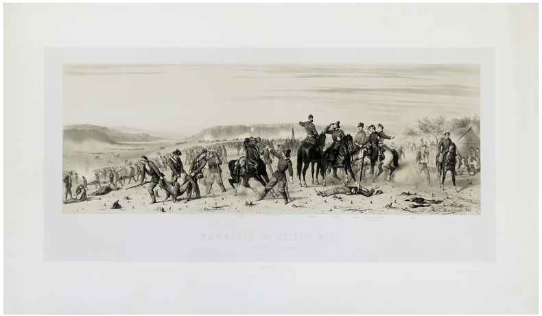
d'ORLEANS (François).
[GUERRE DE SÉCESSION/VIRGINIE] Bataille de Gaine's Mill. Virginie (27 juin 1862).
[1862]. 366 x 740 mm.
Bookseller reference : LBW-5489
|
|
|
D'Orta, Piemme and Enrika
Together in Pompeii
No marks or inscriptions. No creasing to covers or to spine. A lovely clean very tight copy with bright unmarked boards and no bumping to corners. Protected in fully-removable proprietary plastic sleeve. 64pp. Tucked in is a large fold-out plan of Pompeii. Travel guide with 110 coloured illustrations.

|
|
|
D'YEU Pierre. (Pierre Marie Alexis DIEULEFILS - Photographe et éditeur de cartes postales actif en France et à Hanoï à partir de 1888)
SUR LA CÔTE INDOCHINOISE. Aux ruines d'Angkor. En Cochinchine. En Annam. Au Tonkin.
Paris A.Paul, C.Vigier, Editions coloniales 1923 in-12 broché 1 volume, broché crème (paperback) in-octavo Editeur (22 x 14 cm), dos et couverture imprimés et illustrés en noir, 3 toute petites taches de café au niveau du titre sur la 1ère de couverture (mais vraiment trés légères), toutes tranches lisses, Rarissime recueil de poèmes illustrés de 26 planches-photographiques hors-texte à la sépia et de 14 photographies in-texte en noir. Imprimées sur beau papier, tirées des collections du photographe Dieulefils, 186 pages, 1923 Paris, A.Paul, C.Vigier, Editions coloniales et chez l'auteur, à Malestroit (Morbihan) Editeur,
Bookseller reference : 23423
|
|
 Receive by email
 Download as PDF document
 RSS feed


