|
Cooley, John K. (maps by Charles McDonnell)
BAAL CHRIST AND MOHAMMED - RELIGION AND REVOLUTION IN NORTH AFRICA
New York: Holt Rinehart and Winston 1965. HC. good white cloth hardcover no dustjacket - EX-LIB w/one mark. 369pp. Holt, Rinehart and Winston unknown
Bookseller reference : BOOKS060158I
|
|
|
COOLIDGE W. A. B.; COMBE Edouard (trad.):
Les Alpes dans la nature et dans l'histoire.
Lausanne-Paris, librairie Payot et Cie, 1913. Fort volume in-8 de XI-547 pages, demi-veau brun, dos lisse orné de filets, roulettes, fleurons et titre dorés et de roulettes et filets à froid, tête dorée. Les 2 mors sont fendus en tête sur 4 cm. et frottés pour le reste. Ce défaut mis à part, en belle condition, intérieur frais.
Bookseller reference : 10236

|
|
|
COON, CARLETON S & WATSON, ALDREN A (Maps & Drawings)
The Hunting Peoples
Jonathan Cape 1972. FIRST EDITION super octavo hardcover VG in d/w VG-; all our specials have minimal description to keep listing them viable. They are at least reading copies complete and in reasonable condition but usually secondhand; frequently they are superior examples. Ordering more than one book may reduce your overall postage costs. Jonathan Cape 1972 hardcover
Bookseller reference : 353762
|
|
|
Cooper, J.R.
La Poile-Cinq Cerf Map-Area, Newfoundland - C.S.C. Memoir 276 (No. 2516)
62 pages. Printed upon glossy stock. Black and white aerial photo frontis of La Poile Bay looking north. Fold-out figure at page 41. Colour map (1036A) measuring 28" x 34" stored in pocket inside back board. Average wear. Binding tight. Former university copy with several related internal markings. A quality copy. Book

|
|
|
Cooper, James Fenimore (1789-1851).
HISTORY OF THE NAVY OF THE UNITED STATES OF AMERICA. Second Edition, with Corrections. In Two Volumes.
Two Volumes + Two Frontis maps. Age stained. Early inked ownership. XLib stamps embossed in blind on title pages and elsewhere. Library name stamped on edges. Large 12 mo. 230 mm. Rebound in library buckram. Raised bands. Leather spine labels worn with some loss. Before becoming a famed author Cooper had some years of service in the navy. AI 40-1660. Hardbound. Very good. Scarce original edition. **PRICE JUST REDUCED! JUN5 BOX 2
|
|
|
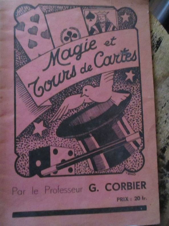
Corbier (professeur G.)
Magie et tours de cartes
Chez l auteur paris sans date In8 broché 12 pages
Bookseller reference : 5926
|
|
|
Corey, Cindy. Drawings by Keith Rose. Maps by Kate Russell Forbes.
Exploring the Lighthouses of North Carolina
Chapel Hill:: Provincial Press. Illustrated throughout with black & white & color illustrations Very good copy in Trade Paperback . Very Good. Soft cover. 1st. 1982. Provincial Press paperback
Bookseller reference : 099330
|
|
|
Corfield Robin S.; Williams Harold maps.
Hold Hard Cobbers: Volume Two 1930 - 1990: The Story of the 57th and 60th and 57/60th Australian Infantry Battalions 1912 - 1990.
Glenhuntly VIC: 57/60th Battalion AIF Association 1991. Hardback small quarto dustjacket very good condition in very good dustjacket black & white photos colour frontispiece maps minor edgewear jacket. Heavy and extra postage may be requested to destinations outside Australia. 351 pp. Volume 2 only. This volume - the second of two volumes - begins in 1930 when the 57th and 60th Battalions were linked together firstly in the CMF and later in the 2nd AIF. The 57/60th Battalion Association was formerly established in 1946 and its life and times are part of this story. This book was first issued at the 45th Anniversary of the Association in April 1991. The first volume describes the beginnings of the Units in 1912 and 1915 and follows them through the Great War. The second volume this listing follows them through from 1930 to 1990. Contains a full listing of the Roll of Honour 1216 names Decorations and Awards and the Nominal Roll are published for the first time. The father of author Robin Corfield was an officer in the 57/60th Battalion in the mid-1930s. Limited edition of 2000 copies. Note: this listing volume 2 only. 57/60th Battalion (AIF) Association hardcover
Bookseller reference : 41204 ISBN : 0646040995 9780646040998

|
|
|
CORION (A.).
Nouveau plan de la ville de Paris.
Paris, A. Corion, 1858. En 36 sections montées sur toile vert bouteille et repliées, formant un plan de 646 x 940 mm, monté dans une reliure de chagrin marron avec pièce de titre rouge au dos ; carte des environs de Paris contrecollée au dos du premier plat.
Bookseller reference : LBW-8933

|
|
|
CORNIC (Alain).
France. Bourgogne.
1979. 99,5 x 149,5 cm.
Bookseller reference : LBW-8297

|
|
|
CORNIC (Alain).
Saône & Loire. Jardin Roman.
[Paris], Publicadvise, [vers 1975]. 99,5 x 149,5 cm.
Bookseller reference : LBW-8298

|
|
|
CORNILLOT Lucie; PIQUARD Maurice; DUHEM Gustave; GAZIER Georges:
Visages de la Franche-Comté.
Paris, Ed. des Horizons de France, 1945. 1 volume broché (185 x 236) de 197-[4] pages, couverture illustrée couleurs.
Bookseller reference : 2405

|
|
|
Cornish, George A.
A Canadian School Geography - with Supplementary Chapter in British Columbia
498 pages. Numerous sketch maps, diagrams and illustrations. Includes supplementary chapter on British Columbia. Authorized for use in the schools of British Columbia, Manitoba, Nova Scotia, Quebec and Saskatchewan. Boards covered by dark green leatherette. Hinges going. Above-average but not excessive wear. Book

|
|
|
CORONELLI Vincenzo (Venezia 1650 - 1718)
Almanacco per l'Anno Bisestile…dalla Natività di Christo MDCLXXXVIII
Rarissimo almanacco per l'anno bisestile del 1688 di Vincenzo Maria Coronelli. L'opera è dedicata all'Abate Rezzonico, il cui ritratto è in alto a sinistra. Membro di una nota famiglia comasca, eletto governatore dello Stato Pontificio, nel 1687 assunse anche il titolo di patrizio della Serenissima. Per ogni giorno dell'anno sono ricordati gli eventi più importanti legati alla storia della Republica di Venezia.Il calendario è circondato da una bella cornice ornamentale incisa, nel tipico stile del Coronelli, dove entro delle monete sono raffigurate le piante di 24 città della Grecia, sotto il controllo di Venezia.L'opera, una separata pubblicazione, si vendeva presso la bottega dell'editore Domenico Padoani, situata a Rialto.Coronelli aveva già realizzato un calendario simile nel 1666. L'opera è assai rara e ne abbiamo riscontrato un solo esemplare conservato alla Marciana di Venezia.Incisione in rame, in ottimo stato di conservazione. Extremely rare almanac for the year 1688 by Vincenzo Maria Coronelli. The work is dedicated to Abbot Rezzonico, whose portrait is in the upper left. Member of a famous family of Como, was elected governor of the Papal States, in 1687 he also assumed the title of patrician of Venice. This almanac, for each day of the year, remember the most important events related to the history of the Republic of Venice. The calendar is surrounded by a beautiful ornamental engraved frame, in the typical style of the Coronelli, where the coins are represented by plants of 24 cities of Greece, mostly in Morea, under the control of Venice. The work, a separate publication, was published by the workshop of Domenico Padoani, in Rialto. Coronelli had already made a similar work in 1666. The almanac is very rare and we have found only one example preserved in the Marciana of Venice. Copper engraving, in excellent condition.

|
|
|
CORONELLI Vincenzo (Venezia 1650 - 1718)
Roma / intagliata e dedicata da Pietro Ridolfi nell'Accademia Cosmogra[fi]ca degli Argonauti all'eccllentissimo sig[nor]e An
- RARA PRIMA EDIZIONE -Incisa da Pietro Ridolfi per l'abate Coronelli, questa rara pianta della città viene per la prima volta pubblicata nel rarissimo Citta, Fortezze e, Isole, e Porti principali dell'Europa in Pianta et in Elevatione, Descritte, e Publicate Ad uso dell'Accademia Cosmografica degli Argonauti dal Padre Maestro Coronelli Lettore, e Cosmografo della Serenissima Republica di Venezia, edito a Venezia da Domenico Padovani nel 1689. Coronelli visse un periodo di straordinaria fecondità editoriale a partire dal 1689, quando ebbe la cattedra di geografia presso l'Università alle Procuratie, con la pubblicazione, nel 1690, del primo volume dell'Atlante Veneto. In effetti sotto il nome di Atlante Veneto va tutta la raccolta di tredici opere composte nell'arco del decennio successivo, dall'Isolario allo Specchio del mare. In realtà solo alcune di tali opere possono definirsi atlante, mentre altre, sono opere di compilazione o semplici raccolte di vedute e fortificazioni come questa rara raccolta. Contrariamente a quanto dichiarato da Marigliani, questa è la prima edizione della pianta della città, e non quella che reca la data 1698 (oltre una ricca cornice ornamentale), pubblicata in onore del Duca di Parma Francesco Farnese.Si basa, come indicato da Scaccia Scarafoni, sulla piccola pianta del Falda. Tuttavia si tratta di una derivazione arbitraria, con una raffigurazione in alzato solo di pochi edifici principali. Il grande cartiglio con il titolo, sproporzionato, contiene gli stemmi dei XIV rioni.Meraviglioso esemplare, con grandi margini, di questa rara pianta. - THE RARE FIRST STATE - Plan map, with some large buildings in bird's-eye view. Text on tablet at lower right, with coats of arms of Rome and its rioni. Oriented with east at top. Relief conveyed pictorially. Reduced copy of Falda's small plan of Rome, published 1667. See Huelsen. This example of the map is taken from the very rare Coronelli's Citta, Fortezze e, Isole, e Porti principali dell'Europa in Pianta et in Elevatione, Descritte, e Publicate Ad uso dell'Accademia Cosmografica degli Argonauti dal Padre Maestro Coronelli Lettore, e Cosmografo della Serenissima Republica di Venezia, printed in Venice by Domenico Padovani in 1689. Coronelli lived a period of extraordinary editorial fecundity starting from 1689, when he had the chair of geography at the University at the Procuratie, with the publication, in 1690, of the first volume of the Atlante Veneto. Under the name of Atlante Veneto goes the entire collection of thirteen works composed over the next decade, from the Isolario to the Specchio del mare. Copperplate, with full margins, very good condition. Very rare. Huelsen, C. Saggio di bibliografia ragionata delle piante icnografiche e prospettiche di Roma, 122; C. Marigliani, Le Piante di Roma delle collezioni private, p. 243, n. 150; Scaccia Scarafoni n. 202.

|
|
|
Corporation of the City of Edinburgh
Edinburgh Official Guide plus City of Edinburgh Accommodation Register
Two fine unused publications in their original as-delivered well-scuffed envelope, dated 1963. No marks or inscriptions. No creasing to covers or to spines. Very clean crisp very tight booklets with bright unmarked boards and no bumping to corners. One booklet has a trace of foxing to rear. Fold-out map inside rear cover in perfect condition. 88 + 96pp.

|
|
|
CORREARD F. - SIEURIN E.
Cartes d'?tude pour servir ? l'enseignement de l'histoire : Temps modernes et contemporains (1610-1899).
Cartonn?. 14 pages. 22x29 cm. L?g?rement d?fra?chi.
|
|
|
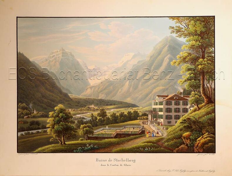
Corrodi, Salomon (1810-1892)
Bains de Stachelberg dans le Canton de Glaris.
Zürich, F. Sal Füssly successeur de Keller et Füssly, um 1835. Aquatinta von Lukas Weber (1811-1860). Bildgrösse: 17,2 x 25,2 cm. Blattgrösse: 22,4 x 29,6 cm. + Wichtig: Für unsere Kunden in der EU erfolgt der Versand alle 14 Tage verzollt ab Deutschland / Postbank-Konto in Deutschland vorhanden +, Abb.
Bookseller reference : 624DG

|
|
|
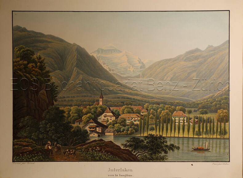
Corrodi, Salomon (1810-1892)
Interlaken vers la Jungfrau.
O.O., um 1935. Altkolorierte Aquatinta von Lukas Weber (1811-1860). Bildgrösse: 17,7 x 25,2 cm. Blattgrösse: 20,9 x 28,2 cm. + Wichtig: Für unsere Kunden in der EU erfolgt der Versand alle 14 Tage verzollt ab Deutschland / Postbank-Konto in Deutschland vorhanden +, Abb.
Bookseller reference : 617DG

|
|
|
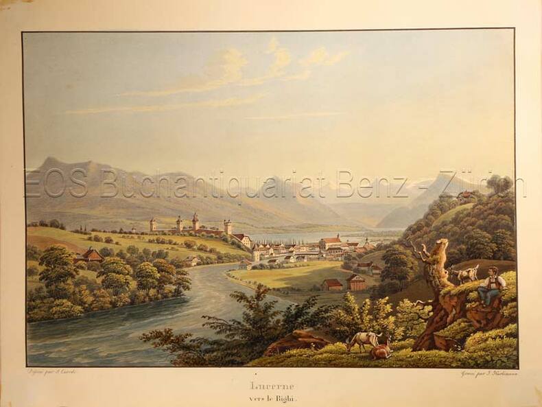
Corrodi, Salomon (1810-1892)
Lucerne vers le Righi.
O.O., um 1935. Altkolorierte Aquatinta von Johann Hürlimann (1793-1850). Bildgrösse: 16,7 x 24,7 cm. Blattgrösse: 20,5 x 27,2 cm. + Wichtig: Für unsere Kunden in der EU erfolgt der Versand alle 14 Tage verzollt ab Deutschland / Postbank-Konto in Deutschland vorhanden +, Abb.
Bookseller reference : 779CG

|
|
|
Corrodi, Salomon (1810-1892):
Bains de Stachelberg dans le Canton de Glaris.
Zürich, F. Sal Füssly successeur de Keller et Füssly, um 1835. Aquatinta von Lukas Weber (1811-1860). Bildgrösse: 17,2 x 25,2 cm. Blattgrösse: 22,4 x 29,6 cm.
Bookseller reference : 624DG
|
|
|
Corrodi, Salomon (1810-1892):
Interlaken vers la Jungfrau.
O.O., um 1935. Altkolorierte Aquatinta von Lukas Weber (1811-1860). Bildgrösse: 17,7 x 25,2 cm. Blattgrösse: 20,9 x 28,2 cm.
Bookseller reference : 617DG
|
|
|
Corrodi, Salomon (1810-1892):
Lucerne vers le Righi.
O.O., um 1935. Altkolorierte Aquatinta von Johann Hürlimann (1793-1850). Bildgrösse: 16,7 x 24,7 cm. Blattgrösse: 20,5 x 27,2 cm.
Bookseller reference : 779CG
|
|
|
CORSE...
Carte d?partementale couleurs au 1/550 000e de la Corse.
Une feuille 30x41 cm.
|
|
|
CORTÉS, Martín (1510-1582).
Breve Compendio de la Sphera y de la Arte de Navegar, con nuevos instrumentos y reglas, exemplificado con muy subtiles demonstraciones. Facsímil de la edición de Sevilla, Antón Alvarez, 1551, con estudio introductorio de Salvador García Franco y Julio F. Guillén Tato.
Zaragoza, Institución Fernando el Católico. 1945. Gran folio; 95 ff., 4 hs., 27 pp., con numerosas ilustraciones xilográficas, esquemas y planos, entre ellos una Carta del Nuevo Mundo. Edición limitada de 500 ejemplares numerados. Cubiertas originales.

|
|
|
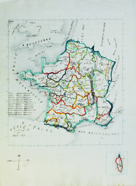
COSSART d'ESPIÈS (Louis Antoine Camille de).
[Carte de France].
[vers 1825-1830]. 52,5 x 39 cm, sur papier vélin.
Bookseller reference : LBW-6580
|
|
|
Cossdorf:
Cossdorf. "Plan der Action, welche d. 20. Febr. 1760 zwischen einem Kaserl. Königl. Ungarischen und Königl. Preussischen Corps bei Cossdorf in Sachsen vorgefallen". Schlachtenplan von Cossdorf in Sachsen, links mit Legende. Kupferstich mit farbigen Truppenaufstellungen aus "Neues Kriegs-Theater ...", 18. Supplement.
Format: 18 x 29,5 cm. *Leicht gebräunt, insgesamt gut erhalten. Landkarten de
|
|
|
COSTA DE LOVERDO Photographies d'époque. Cartes.
Les maquis rouges des Balkans, 1941-1945 : Grèce - Yougoslavie - Albanie.
Couverture souple. Broché. 390 pages. Quelques rousseurs.
Bookseller reference : 205228
|
|
|
Costain, Thomas B. (Bertram); Maps on End Papers [Illustrator]
The Darkness and the Dawn
Doubleday & Co 1959-01-01. Hardcover. Very Good. Doubleday & Co hardcover
Bookseller reference : 201122063
|
|
|
COSTANTIN J.; FAIDEAU F:
Les plantes. Histoire naturelle illustrée.
Paris, Lib. Larousse, 1922. 1 vol. in-4 de 319 p. Demi-chagrin marron, dos lisse orné, plats de percaline verte ornés à froid. Dos passé.
Bookseller reference : 2816

|
|
|
COTE D'AZUR
Carte couleurs au 1/200 000?me.
Une feuille. 98x61 cm.
|
|
|
COTES-DU-NORD
Carte grav?e (en noir) du d?partement. Extrait du Petit Atlas National. Fin XIXe.
1 feuille 24x30 cm. Rousseurs.
|
|
|
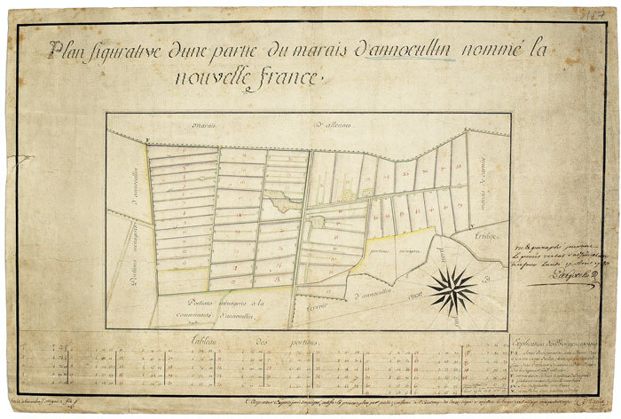
COTTIGNIES (Alexandre J.). MANUSCRIT.
Plan figurative d’une partie du marais d’Annœullin nommé la Nouvelle France.
1780. 165 x 420 mm.
Bookseller reference : LBW-527
|
|
|
Cotton, Peter Neive
Vice Regal Mansions of British Columbia
118 pages including index and black and white illustrations. A remarkable volume of archive photographs, early maps, business documents and correspondence from British Columbia's past. Letter and diary excerpts give extraordinary insights into the personalities and problems facing these key figures. Book clean, bright and unmarked with very light wear. Light wear to illustrated dust jacket. Nice copy. Book
|
|
|
Cottreau (Marcel), Le Chartier (Henri).
Indes, Extrême-Orient, Océanie. 1ere partie : de Marseille à Colombo. 2e partie. De Ceylan en Océanie.
Paris, Librairie du tourisme, (1910-1911). 2 tomes en 2 vol. in-12 X-394 pp., 3 cartes repliées volantes à l'intérieur du plat inférieur (Indes, Île de Ceylan, Planisphère) ; XXX-734 pp., 2 cartes repliées volantes à l'intérieur du plat inférieur (Australie et Tasmanie, Planisphère), percaline rouge avec titre doré sur le dos et le plat supérieur (reliure de l'éditeur).
Bookseller reference : 43078

|
|
|
COUDRAIN (Brigitte).
Carte de voeux illustrée d'une gravure originale signée.
Paris Société des peintres-graveurs français 1999 1 vol. Broché Carte de voeux dépliante sur Arches illustrée d'une belle eau-forte en couleurs (13 x 12 cm) signée par Brigitte Coudrain. En parfait état.
Bookseller reference : 109098
|
|
|
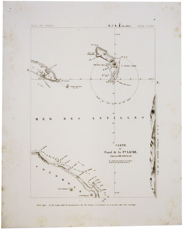
COULIER (Philippe-Jacques).
[CURACAO/BONAIRE] Carte du fanal de la Pte. Lacre d'après une carte espag.le de 1816.
Paris, [1844-1848]. 276 x 200 mm.
Bookseller reference : LBW-2415
|
|
|
COULIER (Philippe-Jacques).
[CURACAO] Plan du phare projetté de Sta Anna, de Curaçao, d'après celui de l'amirauté anglaise, de 1837.
Paris, [1844-1848]. 280 x 200 mm.
Bookseller reference : LBW-2416

|
|
|
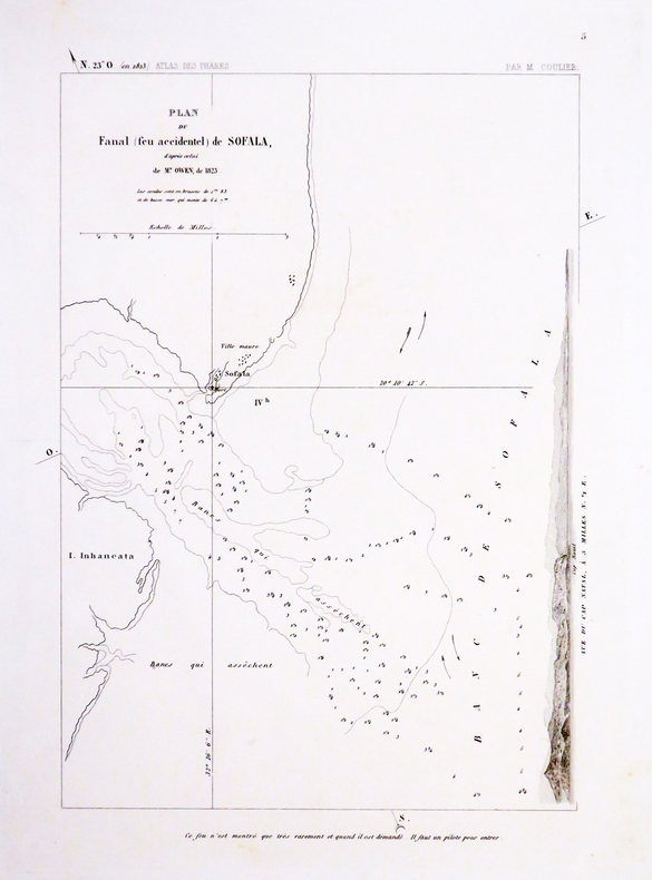
COULIER (Philippe-Jacques).
[MOZAMBIQUE] Plan du fanal (feu accidentel) de Sofala, d'après celui de M.r Owen, de 1823.
[Paris, 1844-1848]. 285 x 205 mm.
Bookseller reference : LBW-4531
|
|
|
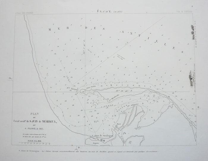
COULIER (Philippe-Jacques);
[NICARAGUA] Plan du fanal accid.el de S. Juan de Nicaragua, par G. Peacock, de 1832.
Paris 1844-1848 205 x 275 mm.
Bookseller reference : LBW-1169
|
|
|
Coupland, Douglas
Souvenir of Canada
book in as new condition. Soft covers with self-wraps. 143pp. An introduction to Canada, very well illustrated.

|
|
|
COURSIER, Alain.
Le Nord autrefois. Valenciennois - Avesnois - Cambrésis - Douaisis.
Editions Horvath, 1985 ; grand in-8°, broché, couverture rouge illustrée d'une carte postale en noir et blanc, titre en blanc au 1er plat, titre en noir et ocre au dos; 183pp. illustré de très nombreuses cartes postales et photographies anciennes.
Bookseller reference : c6343
|
|
|
COURTELLEMONT Gervais:
Voyage au Yunnan. Ouvrage accompagné de 23 gravures et de 2 cartes.
Paris, Plon-Nourrit, 1904. In-12 de [6]-XIII-298-[2] pages, demi-chagrin rouge, dos à nerfs orné de d'oiseau doré.
Bookseller reference : 20060
|
|
|
COUSIN (Jules)
Notice sur un plan de Paris du XVIe siècle. nouvellement découvert à Bâle
Paris, 1875 in-8, 31 pp., broché.
Bookseller reference : 174869
|
|
|
COUTANS (Guillaume).
Atlas topographique en XVI feuilles des environs de Paris, à la distance d'environ 8 myriamètres, ou 18 lieues, dans sa moyenne étendue dressé sur une échelle de 31 millimètres pour 2 kilomètres, 4 Lignes pour 300 Toises, par Dom. G. Coutans ex-Bénédictin. revu, corrigé et considérablement augmenté par Charles Picquet, Géographe-graveur ; dédié & présenté au Ier Consul Bonaparte.
A Paris, chez Picquet et chez Deterville, 1800 - an 8. 1 tableau d'assemblage et 16 feuilles de 125 x 40 cm. chacune (12, 5 x 20,3 cm repliées), entoilées, conservées dans 2 étuis de l'époque en demi-maroquin rouge, dos lisse orné.
Bookseller reference : 43496

|
|
|
COUTANS Dom., PICQUET Ch.
Atlas topographique en XVI Feuilles des environs de Paris (...) par Dom G. Coutans, Revu, corrigé & considérablement augmenté (...) par Charles Piquet. Volume 2 seul.
Paris, chez Ch. Piquet, Deterville,c 1800. 1 feuille dépl. couleurs, avec titre et assemblage, 4 cartes dépl. aquarellées, 1 livret "Table alphabétique" "Dictionnaire de l'Atlas topographique des environs de Paris, en 16 feuilles par Dom Coutans." petit in-4, VIII- 88 pp., broché sous couvertures en attente, la planche de titre et les 4 cartes sont toilées et pliées, le tout est rassemblé dans un coffret imitant à l'imitation d'un livre, boîte frottée, les cartes sont en très bel état et les coloris sont superbes.
Bookseller reference : 4773
|
|
|
COUTANS, Dom Guillaume ; PICQUET, Charles
[ Atlas topographique en seize Feuilles des Environs de Paris, à la distance d'environ huit myriamètres, ou dix-huit lieues dans sa moyenne étendue ]
[ Dressé sur une Échelle de 31 Millimètres pour 2 kilomètres (4 Lignes pour 300 Toises), par Dom G. Coutans, Fr. bénédictin, revu, corrigé & considérablement augmenté, d'après nombre de cartes précieuses & plans particuliers, tant gravés que manuscrits par Charles Picquet, géographe-graveur ; dédié & présenté au premier Consul Bonaparte ] 4 cartes entoilées dépliantes, format de chaque carte : 123 x 78 cm, format total de l'ensemble réuni : 256 x 156 cm, sous étui cartonné ancien ouvert à dos de bois (format 33,7 x 22 cm), Chez Ch. Picquet, Palais Egalité, Galerie de Bois, n° 254 bis, s.d. [circa 1800 ]
Bookseller reference : 66391

|
|
|
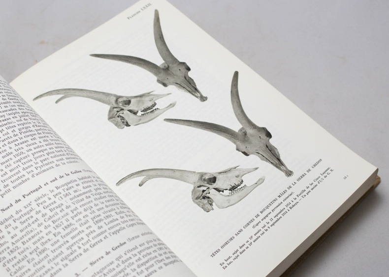
COUTURIER Marcel A. J.:
Le bouquetin des Alpes. Capra Aegagrus Ibex Ibex L.
Grenoble, 1962. Un volume in-8 de XI-[2]-1564-[4] pages, pleine toile beige imprimée de l'éditeur.
Bookseller reference : 18589
|
|
|
COUTURIER Marcel A. J.:
Le chamois. Rupicapra rupicapra (L.) Préface de Marcellin Boule.
Grenoble, Arthaud, 1938. Un volume in-8 de XI-[2]-855-[2] pages, pleine toile verte imprimée de l'éditeur, couverture et dos conservés.
Bookseller reference : 18590

|
|
 Receive by email
 Download as PDF document
 RSS feed


