|
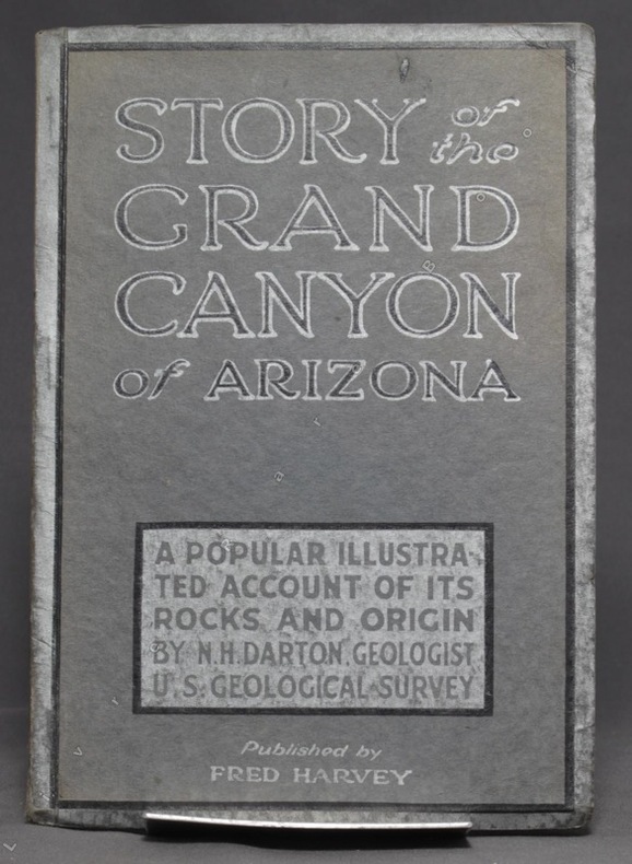
DARTON N. H:
Story of the Grand Canyon of Arizona. A popular illustrated account of its rocks and origin.
Kansas City, Fred Harvey, sans date. In-8 broché de 74-[6] p., couverture grise imprimée noir et argent.
Bookseller reference : 6257
|
|
|
Darvill, Fred T.; b/w Maps [Illustrator]
North Cascades Highway Guide
Reliance Printers 1973-01-01. Paperback. Good. Good condition with some wear to cover. Reliance Printers paperback
Bookseller reference : 20-28357
|
|
|
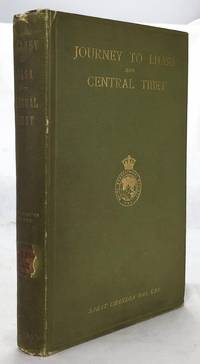
Das, Sarat Chandra (edited By WW. Rockhill; Frontispiece Photo of Author, 2 Large Folding Maps, 4 Folding Color Plans [Illustrat
Journey to Lhasa and Central Tibet
John Murray 1/1/1902. Stated 2nd Edition revised. Hardcover. Good. Bound in publisher's green cloth. Gilt lettered and stamp of the Royal Geographical Society on front cover. Library stamps and markings. 285 pages. 34 illustrations and maps 6 of which are folding. Large color map of Tibet at rear. Many of the plates are stamped with library stamps on blank side. <br> Sarat Chandra Das 1849-1917 was a Bengali scholar of Tibet. Das has been described as "a traveler explorer.linguist a lexicographer an ethnographer and an eminent Tibetologist." Das was also a British spy. Born in Chittagong Das trained as an engineer in Calcutta. He became headmaster of the Bhutia Boarding School in Darjeeling. Bhutia was a school for Sikkimese and Tibetan boys many of who would be trained to fill a special place in the British colonial regime the role of a Pundit. Das became a "pundit" and an instructor at the school for British intelligence. Pundits acted as a network of British-trained operatives who were tasked to make inroads in the foreboding inner regions of Asia where white embassies could not gain entry. Tibet and other inland areas were increasingly gaining attention from competing British Russian and Chinese economic and strategic interests. Derek Waller speculates that the character of Huree Chunder Mookerjee in Kipling's Kim was based on Das p.193. As a teacher Das learned Tibetan to speak with his students. He read the limited books on the region available notably of Bogle 1773-5 and Manning's travels 1811 to Tibet. Manning and Bogle were the last successful British explorations of Tibet a nation who steadfastly resisted western intrusion. Das's language ability secured him entry with his colleague Lama Ugyen Gyasto to Tashilhunpo monastery in 1879 as the Prime Minister wished to learn Hindi from him. In 1881 Das returned to Tashilhunpo and made his way to Lhasa Sakya and the Tsangpo River. There he met with Thupten Gyatso the 13th Dalai Lama d. 1933 and returned to Darjeeling with a Yak loaded with over 200 Tibetan manuscripts. After Das was revealed to be a British agent Tibetan authorities increased restrictions on travelers and the Minister who had sponsored his entry was put to death. What makes Das's expedition so interesting is that he successfully brought back a wealth of information on an unknown land to the larger world. The Tibet that Das glimpsed is now gone with the passage of history and the destructive forces of modernity and Chinese domination. This book compiles the story of Das's journey his reports photographs diagrams ethnographic observations etc of a lost Tibet. Das went on to become an important Tibetan scholar and author an extensive multi-volume dictionary. The British would not successfully return to Tibet until 1903-4 with Colonel Francis Edward Younghusband's exhibition invasion and massacre of ~5000 Tibetans. Significantly Younghusband was the President of the Royal Geographical Society which notably published the 1902 edition of Das's book. An interesting and dark connection to Das's legacy. Ref: Derek Waller's The Pundits: British Exploration of Tibet and Central Asia. University Press of Kentucky 1990 pp. 193-209. Also Samanth Subramanian's superb piece in the New York Times Magazine March 20 2016 p. MM61. Peter Hopkirk The Great Game: The Struggle for Empire in Central Asia Kodansha 1992. Yakushi D55 Yakushi D356. Marshall 1459 John Murray hardcover
Bookseller reference : 1607050057
|
|
|
Dauphin County Parks.
COMPREHENSIVE PARK, RECREATION AND OPEN SPACE PLAN FOR DAUPHIN COUNTY.
np. Zerox copy. Illustrated with photographs and large folding maps. 4to. Original spiral bound wraps. PA PAMPH 20_7 BX2
|
|
|
DAUPHINÉ par Paul VEYRET, R. AVEZOU, R. FERNANDAT, P. VAILLANT ...
Visages du Dauphiné. Richement documenté (héliogravures, planches en couleurs, figures, cartes).
Paris, éd. Horizon de France 1949. Bel exemplaire broché, pet. in-4 carré, 207 pages + planches.
Bookseller reference : AUB-4575
|
|
|
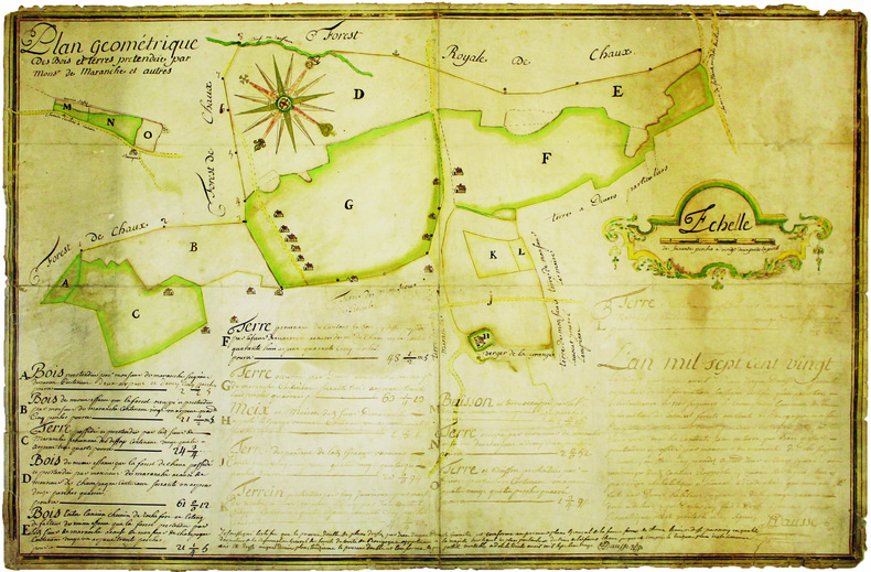
DAUSSE (Jean-Jacques). MANUSCRIT.
Plan géométrique des bois et terres prétendue par Monsr de Maranche et autres.
1720. 510 x 778 mm, monté sur toile.
Bookseller reference : LBW-4140
|
|
|
DAUSSY (Pierre).
[MARSEILLE & PIOMBINO] Carte des côtes de la mer Méditerranée. Partie comprise entre Marseille et Piombino.
[Paris], Dépôt-Général de la Marine, 1832. 605 x 885 mm.
Bookseller reference : LBW-8314

|
|
|
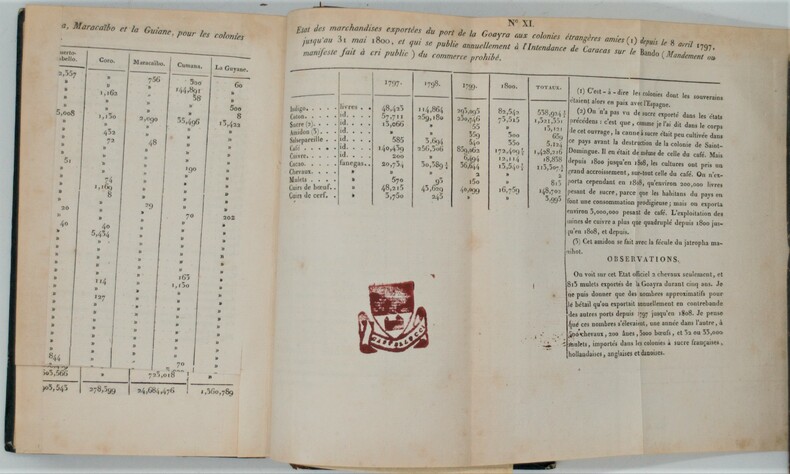
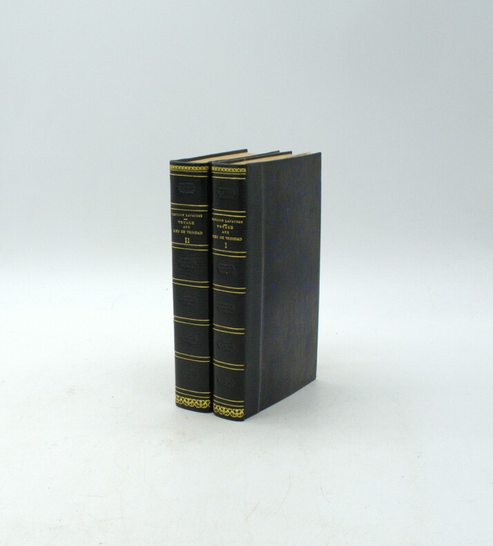
Dauxion-Lavaysse , Jean-Joseph
Voyage aux îles de Trinidad, de Tabago, de la Marguerite et dans diverses parties de Vénézuéla, dans l'Amérique méridionale.
Paris, F. Schoëll, Libraire, 1813. In-8 (20,5 x 13,5 cm),XXVI-411 pp.,3ff-480pp-4ff (table et errata), illustré de 3 cartes déplantes et 5 tableaux dépliants .Reliure de l'époque demi-basane havane, dos lisse orné, manque au dos ,un plat détaché ,charnières faibles, cachets répétés, déchirure au pli à 1 carte. Édition très rare.
Bookseller reference : PHO-844
|
|
|
DAUXION-LAVAYSSE, Jean-Joseph
Voyage aux îles de Trinidad, de Tabago, de la Marguerite et dans diverses parties de Vénézuéla, dans l'Amérique méridionale.
Paris, F. Schoëll, Libraire, 1813. In-8 (20,5 x 13,5 cm), XXVI-411 pp.,3ff-480pp-4ff (table et errata), illustré de 3 cartes dépliantes et 6 tableaux dépliants, demi-maroquin moderne à long grain bleu nuit, dos lisse, auteur, titre et tomaison dorés, filet et roulette dorés, fers à froid rousseurs.
Bookseller reference : PHO-1916
|
|
|
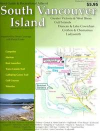
Davenport Maps
Street & Recreational Guide of South Vancouver Island
paperback. Good. Access codes and supplements are not guaranteed with used items. May be an ex-library book. paperback
Bookseller reference : 1896888127.G ISBN : 1896888127 9781896888125
|
|
|
Davenport, Bishop.
A NEW GAZETTEER, OR GEOGRAPHICAL DICTIONARY. Of North America And The West Indies. A New Edition With Alterations And Additions.
536 p. LACKS folding map. Lacks front fly leaves. Text illustrations. XLib blind stamp of A. Herr Smith Memorial Library on title page. XLib stamp of Free Public Library, Lancaster, PA on title page. XLib stamp on all edges. First three signatures damp stained on bottom corner. Foxed. First four leaves including title page chipped at edges. 8vo. 235 mm. Original full leather binding, worn. Front board fragile. Hardbound. Fair. S&S/AI 55257. PAIMP 10
|
|
|
David Biggs
This is Cape Town
No marks or inscriptions. A very clean very tight copy with bright unmarked boards and no bumping to corners. Dust jacket not price clipped or marked or torn with rubbing to top of spine and minor traces of storage. 160pp. A lavishly illustrated study of Cape Town in South Africa beginning with a detailed profile of the city and superb colour photographs showing the landscape and seascape, the culture, the buildings and the people.

|
|
|
David Butler; Photos, Maps [Illustrator]
The Fall of Saigon: Scenes from the Sudden End of a Long War
Simon & Schuster 1985. First Edition. Hardcover. New. 9x6x1. As new remainder copy with black remainder mark on bottom edge. Dust jacket fair wrapped in Mylar archival cover. Black & white photos throughout. 510 pp. Index. CLEARANCE ITEM-PRICE REDUCED. Free shipping in USA. Simon & Schuster hardcover
Bookseller reference : 114230709002 ISBN : 0671466755 9780671466756
|
|
|
David Butler; Photos, Maps [Illustrator]
The Fall of Saigon: Scenes from the Sudden End of a Long War
Simon & Schuster 1985-04-01. Hardcover. New. New. In shrink wrap. Looks like an interesting title! Simon & Schuster hardcover
Bookseller reference : Q-0671466755 ISBN : 0671466755 9780671466756
|
|
|
David Hodgson, Garitt Roch, Loren Gillilan (Maps)
Fallout 76: Official Guide
Edition: First . Good Condition. No Hassle 30 Day Returns Ships Daily Underlining/Highlighting: NONE Writing: NONE Publisher: Prima Games Pub Date: 11/14/2018 Binding: Paperback Pages: 544 paperback
Bookseller reference : 6908839 ISBN : 074401901X 9780744019018

|
|
|
David Lavender; Illustrator-Illustrated by maps
The Rockies
Harper & Row Publishers 1968. First Edition. Hardcover. Good. 0x0x0. 1968 Harper and Row hard cover with price clipped dust jacket Inscribed by the Author stated first edition has a fold out map last page has a small taped tear bottom edge is dented corners are worn dust jacket is in mylar from a private collector has a small yellow sticker that says signed on the spine binding is strong scans available on request b102 Harper & Row, Publishers hardcover
Bookseller reference : 010812002
|
|
|
David S. Kaplan; with maps by Mary White Arrigo
Fishing Guide to Middlesex Stocked Trout Streams
Purgatory Cove Press 2004. Book. Good. Soft cover. Good condition. Some edge and corner wear. Outside page edges with some soiling. All intact. No writing or marking. Not Ex-Library. Purgatory Cove Press Paperback
Bookseller reference : 10647 ISBN : 1887079033 9781887079037
|
|
|
David, Joy (editor)
The Hidden Places of North Yorkshire
No marks or inscriptions to contents. No creasing to front cover or to spine, small crease to lower corner of rear cover. A very clean very tight copy with bright boards, slight damp effect to part of rear fore-edge and no bumping to corners. Fold-out map at rear in excellent condition. 216pp. An easily used book which takes you on a gentle meander through the beautiful countryside of North Yorkshire. As well as some of the well-known tourist attractions are those little known features which are so easily missed.

|
|
|
Davidson B.; photos maps drawings Illustrator
THE LOST CITIES OF AFRICA K4
Little Brown and Company 1959-01-01. Paperback. Very Good. Little, Brown and Company paperback
Bookseller reference : 200605031
|
|
|
Davidson, Marshall B. and McTigue, Bernard.
TREASURES OF THE NEW YORK PUBLIC LIBRARY.
304 p. Numerous photographic illustrations by Jonathan Wallen. 4to. Original full cloth binding. Dust jacket. First Edition. Published at $60.00. Fascinating tour through the collections of one of the greatest American libraries. The New York Public Library houses more than 8 million volumes, 23 million manuscripts and half a million recordings. Includes: Washington's Farewell Address; the first Gutenberg B ible ever brought to this hemisphere; rare globes and maps; musical scores; and much more. A lavish history. **PRICE JUST REDUCED! REF1
|
|
|
Davis, Julia Gray, Caroline (Maps)
No Other White Man: The Lewis and Clark Expedition 1804-1806
New York: E. P. Dutton & Co. Inc. 1938. First Edition. Hardcover. Very Good/No Dust Jacket. 8.35 x 5.70 x 1.30 inches. "No Other White Man"" by Julia Davis featuring maps by Caroline Gray is a hardcover edition originally published by E. P. Dutton and presented here as a 6th printing from 1938. This edition is bound in vibrant orange cloth with striking bold black lettering on the cover.The book is in VG- Very Good Minus condition and does not come with a dust jacket. While the covers remain in good shape it's important to note some signs of age and use. The spine ends have slight indentations and the spine itself shows some sun-fading. There are faint droplet stains on both the front cover and spine. These characteristics add a touch of character to this vintage edition.The binding remains square though there's a slight gap at the head of the spine. This is a common occurrence from shelf storage over the years. A light abrasion and a stamp partially marked out are present on the front flyleaf. Some foxing can be observed on the first few pages.Despite these age-related imperfections the interior pages are clean and free from markings ensuring that the text remains legible and enjoyable to read.Rest assured that the book will be packaged with care to safeguard it from the elements during shipment. You will receive a USPS electronic tracking number at no additional cost to keep you updated on the book's delivery progress.If you require more information or additional images of the book please don't hesitate to reach out. Your satisfaction is a top priority and I'm here to assist you with any further details or assistance you may need. E. P. Dutton & Co., Inc. hardcover
Bookseller reference : 15987
|
|
|
Davis, K.; b & w Plates, Maps [Illustrator]
Britons and Saxons: The Chiltern Region
Phillimore 1982. Hardcover. Very Good. 9x7x0. Hardcover book is pre-owned and in great condition with minimal signs of wear or use on cover corners spine and/or dust cover. Pages are clean and unblemished. A great copy! Phillimore hardcover
Bookseller reference : MED-gs-Britons-060623-vg ISBN : 0850334187 9780850334180
|
|
|
DAVIS, Lieu.-Col. T. B. & FLOWER, JOHN (Illus/Maps)
The Story of 98th Field Regiment Surrey and Sussex Yeomanry Q. M. R. R. A. T. A. and 144th Field Regiment Surrey and Sussex Yeomanry r. a. T. A. 1939-1946
Ditchling Press 1980. Octavo red heavy card boards gilt lettering to spine gilt military motifs to front board illus eps frotnispiece xvii 370pp folding maps throughout VG light creasing & bruising to spine extrems & board corners light foxing to page edges & eps in d/w VG light creasing to edges moderate sun fading to spine light chafing & soiling to covers price clipped Ditchling Press 1980 hardcover
Bookseller reference : 252090
|
|
|
Davis, Paul M., And Hubert K. Clay ; Drawings By John F. Hubacek And Allen W. Hale, Many Photographs; Fold-Out Maps
History Of Battery "C" 148Th Field Artillery American Expeditionary Forces "Powder River To The Rhine
Colorado Springs: Paul M. Davis And Hubert K. Clay / Out West 1919. 1st Edition 1st Printing. Hardcover. Very Good. 255 Pp. Red Leather Spine Dark Red Cloth Boards Gilt. First Printing. Lightly Used Gilt Brilliant Fraying Along Bottom Edge Of Spine And At Upper Front Tip Tiny Frays At Two Lower Tips And At Top Edge Of Spine Hinges Tight No Marks. <br/> <br/> Paul M. Davis And Hubert K. Clay / Out West hardcover
Bookseller reference : 042710

|
|
|
Davis, Richard Harding & Maps and Charts Plates
Captain Macklin
Charles Scribner's Sons. Good with no dust jacket. 1919. Hardcover. Minor wear to the cover. Minor spotting throughout the pages . Charles Scribner's Sons hardcover
Bookseller reference : 119566
|
|
|
Davis, William C.; Maps, 46 Illus & 8
Battle At Bull Run A History of the First Major Campaign of the Civil War
Norwalk CT: Easton Press. Fine with no dust jacket. 1996. Full Leather. Fine full leather edition no names or other marks. ; 8vo 8" - 9" tall; 298 pages . Easton Press hardcover
Bookseller reference : 23672

|
|
|
Davison, Brian K.
The Observer's Book of Castles
185 pages. Most people are attracted by the brooding majesty or picturesque ruins of castles. This work provides a wealth of detailed information about them, often illustrated by fascinating historical anecdotes. With 46 line drawings, 12 black and white illustrations and 3 maps. Dust jacket bright with light wear and price clipped. Book
|
|
|
Dawson, Joan
The Mapmakers' Legacy: Nineteenth (19th) Century Nova Scotia Through Maps
152 pages. Bibliography. Index. Wonderfully illustrated, often in colour. Printed upon glossy stock. Handsomely produced. "Plot's Nova Scotia's growth through the careful examination and analysis of maps from the nineteenth century. An exciting time in Nova Scotia's history, this period saw the first serious attempts to gain knowledge of the entire province, its resources and its inhabitants. Traces developments in our province that today are taken for granted." - from back cover. Clean, bright and unmarked with light wear. A high-quality copy. Book

|
|
|
Dawson, Robert K. [maps]"
Collection of 18 English County Maps Plus Reports for Cumberland Lancashire Leicestershire Norfolk Northamptonshire Northumberland Nottinghamshire Shropshire Somersetshire Staffordshire & Suffolk"
collection of 18 hand coloured folding maps including Derbyshire Devonshire Durham Essex Hampshire Kent Lancashire Leicestershire Norfolk Northamptonshire Northumberland Nottinghamshire Shropshire Somersetshire Staffordshire Suffolk Surrey & Sussex each are by Robert K. Dawson 1798‱861 - an English surveyor and cartographer. Plus reports from some of the counties reports signed L. B. Allen or J. G. S. Lefevre" hardcover
Bookseller reference : 61842
|
|
|
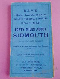
Day Brothers
DAY'S NEW LARGE SCALE CYCLING TOURING & DRIVING ROAD MAP OF FORTY MILES ABOUT SIDMOUTH With One Mile Circles Showing at a Glance the Distance from Sidmouth to any Part
Sidmouth: Day Brothers 1900. Map. Very Good. Unframed. New Edition. Undated but circa 1900 Engraved map main roads coloured orange 445 x 575 mm folding down to 150 x 85 mm with printed blue covers published by Day Brothers "Printers Stationers & Booksellers Observer Office Sidmouth". Generally in very good condition with light general wear and some rubbing to edges of covers. An attractive map. Scarce. Day Brothers unknown
Bookseller reference : 033970
|
|
|
Day, J.H.; Farstad, L.; Laird, D.G.
Soil Survey - Southeast Vancouver Island and Gulf Islands, British Columbia
104 page softcover book plus three large colour maps entitled: Soil Map of Vancouver Island - Duncan/Nanaimo; Courtenay/Campbell; Qualicum/Alberni. Stored in slip case. Report No. 6 of the British Columbia Soil Survey 1959. Gift inscription upon front panel of slip case. Prior owner's name upon each component of contents. Average wear to maps and book. Taped tear along bottom edge of slip case which remains functional. Good working copy of this excellent reference. Book
|
|
|
de Bouman de Ryckholt, Miguel
Prentbriefkaarten: kastelen Belgi = Cartes postales: chateaux Belgique = Post cards: castles Belgium Chateaux Belgique - Kastelen Belgie - Belgium Castles. / Cartes postales anciennes Chateaux Belgique - Prentbriefkaarten Kastelen Belgie - Postcards collection Belgium Castles. set 6 VOLUMES
, Bruxelles, Retro, edition, 1998., Plats de carton origenaux, set 6 volumes ensemble( A-Z), compleet. 21,5x 30,5cm, 208pp, 208pp, 208pp, 208pp,208pp, 208pp, illustration, cartes postales anciennes.
Bookseller reference : 5319
|
|
|
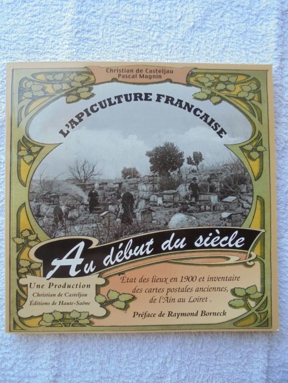
DE CASTELJAU Christian et Pascal MAGNIN.
L'apiculture française au début du siècle.
brochés - 20,5x20,5 - Editions HAUTE - SAÔNE.
Bookseller reference : 19095
|
|
|
DE CROZAT
Manuel de géographie par demandes et par réponses.
Huitième édition augmentée du c de toutes les villes de France, avec les départements dans lesquels elles sont situées, et leurs distances de Paris en lieus de poste, du tableau des principales villes du monde avec leurs distances de la capitale, du traité de la sphère, d’un aperçu de géologie, du siège des Evêchés, cours royales, divisions militaires, de la population, des chefs lieux de préfectures, sous préfectures etc. d’un manuel de géographie ancienne, terminée par le tableau des mœurs, usages et coutumes des peuples des 5 parties du monde par M de FORIS. Cartes gravées, frontispice, titre, 444 pages A Paris chez MORONVAL 1831 in 12 demi cuir rouge, reliure muette. 1) astronomie et sphère: 9 figures en une planche. 2) carte de l’Europe. 3) cartes de l’Asie. 4) Cartes de l’Afrique- de l’Amérique septentrionale et méridionale en une planche dépliante. 5) carte de l’Océanie ou cinquième partie du monde 6) carte du monde connu des anciens. Cartes gravées par HOCQUART.
Bookseller reference : 11966

|
|
|
DE DION-BOUTON.
Carte Routière De Dion-Bouton. Rouen.
Puteaux, De Dion-Bouton, sd. Carte entoilée de 81x95 cm, enroulée sur deux tringles de bois noirci.
Bookseller reference : 6950
|
|
|
DE FER (Nicolas).
Dieppe. Ville de Normandie au Pais de Caux. Port de Mer. Située sur la rivière que forme les 3 ruisseaux de St Sens de NeufChastel et d'Eaulne... Elle fut bombardée par les Anglois l'An 1694.
Sans nom ni date (circa 1715). Gravure en noir mise en couleurs postérieurement, 345 x 276 mm, très bon état.
Bookseller reference : 21651

|
|
|
DE FER (Nicolas).
Dieppe. Ville de Normandie au Pays de Caux. port de Mer Située sur la Rivière que forme les 3 Ruisseaux de St Sens de Neuf-Chastel et d'Eaulne... Elle fut Bombardée par les Anglois l'An 1694.
Sans nom ni date (circa 1702). Gravure en noir, 345 x 256 mm, très bon état.
Bookseller reference : 21653

|
|
|
DE FER Nicolas (1646-1720 circa)
Mappe-Monde, ou Carte Generale De La Terre, Divisee En Deux Hemispheres…
Bell'esemplare della mappa murale del mondo di De Fer, pubblicata per la prima volta nel 1700. Il testo rileva che la mappa è una riduzione della mappa murale in quattro fogli del mondo dello stesso autore, pubblicata per la prima volta nel 1695. De Fer afferma che questa mappa è la prima a tenere conto delle osservazioni astronomiche della Royal Academy of Sciences. Sembrerebbe, infatti, che l'autore abbia consultato diverse fonti per meglio realizzare California, Giappone e Australia.L'Australia è mostrata come incompleta e ancora attaccata alla nuova Guinea. La Nuova Zelanda viene realizzata solo a grandi linee. Il fiume Mississippi ha la sua confluenza con il Golfo del Messico considerevolmente più ad ovest rispetto al suo vero corso. Sono inseriti molti altri nomi di luoghi e il commento scientifico è notevolmente dettagliato.Incisa da Johannes Van Loon, la mappa include vignette che mostrano tuoni, fulmini, tempeste e maree, vulcani, ecc. Le osservazioni celesti sono mostrate nella parte superiore. Acquaforte, bella coloritura coeva, in buono stato di conservazione. Rara. Nice example of De Fer's wall map of the world, first published in 1700. The text notes that the map is a reduction of De Fer's 4 sheet wall map of the world, first issued in 1695. De Fer states that this map is the first map to be prepared based upon the astronomical observations of the Royal Academy of Sciences. In fact, it would appear that different sources entirely have been consulted for California, Japan and Australia.Australia is shown as substantially incomplete and still attached to new Guinea. New Zealand appears in partial outline. The conjectural land bridge from Asia to America is still in evidence. The Mississippi River has its confluence with the Gulf of Mexico considerably west of its true course, based upon La Salle's eroneous reports. There are many more place names on this 2 sheet edition of the wall map. The scientific comentary is quite remarkable and detailed.Engraved by Van Loon, the map includes vignettes show thunder, lightening, tempests and tides, volcanoes, etc. Celestial observations are shown at the top. Etching with fine original colour, good condition. Rare. Shirley, The Mapping of the World, n. 600.

|
|
|
DE FER, Nicolas
Roüen Ville Capitale de Normandie [ Carte - Plan ]. A 15 degrez 45 minutes de Longitude et a 49 degrez 30 minutes de Latitude.
Carte gravée au format 60 x 46 cm, Chez le Sr Danet, Gendre de l'Auteur sur le Pont Notre Dame à la Sphère Royale, 1724, à l'échelle de 500 pas communs
Bookseller reference : 26462

|
|
|
DE FER, Nicolas
Roüen Ville Capitale de Normandie [ Carte - Plan ]. A 15 degrez 45 minutes de Longitude et a 49 degrez 30 minutes de Latitude.
Carte gravée au format 60 x 46 cm, Chez le Sr Danet, Gendre de l'Auteur sur le Pont Notre Dame à la Sphère Royale, 1724, à l'échelle de 500 pas communs Belle carte gravée de Rouen (une très petite brûlure, bel état par ailleurs) Français

|
|
|
De Franciscis, Alfonso
Guide with Reconstructions : Pompeii Herculaneum - Past and Present
No inscriptions or marks. No creasing to covers or to spine. A very clean very firm copy with bright unmarked red pvc bevelled-edge boards and no bumping to corners. Spiral binding in excellent condition. Dust jacket not price clipped or marked or torn or creased. 90pp. This guide to this ancient city which was destroyed by the volcanic action of Vesuvius in 79 AD, is well illustrated including a large number of full page photographs of scenes as they are now with coloured acetate overlays indicating their likely appearance before the eruption.

|
|
|
De L`Isle (Delisle), Guillaume:
Carte d`Artois. Kupferstichkarte mit Grenzkolorit.
48 x 60 cm (Blattgröße: 54,5 x 81 cm). *Frühe Delisle-Karte, zeigt den Nordosten von Frankreich südlich Calais mit dem östlich angrenzenden Gebiet von Belgien. - Guillaume Delisle (1675-1726) war ein französischer Kartograph aus Paris. Delisle war der erste, der eine wissenschaftlich vergleichende Geographie anbahnte, indem er bei seinen Werken auch Reiseberichte und die Werke von Naturforschern benutzte. Er gab zahlreiche Landkarten heraus, die sich durch Eleganz und Schärfe von den früheren Karten unterschieden. - Der breite weiße Rand wurde zeitgenössisch eigens aufmontiert, vermutlich wegen der enormen Blattgröße. Sauber und gut erhalten. / Early print of this Delisle map. The large white edges were mounted separate in contemporarily time (probably because of the large sheet size). Very good condition. Landkarten de
|
|
|
De L`Isle (Delisle), Guillaume:
Carte de France. Dressée pour l`usage du Roy. Teilkolorierte Kupferstichkarte.
48,5 x 62 cm (Blattgröße: 54,5 x 80 cm). *Frühe Delisle-Karte, zeigt detailliert das gesamte Frankreich. Bereits 1703 war eine erste Frankreichkarte von Delisle erschienen, die vorliegende wurde neu gefertigt in veränderter Form und etwas kleinerem Maßstab (also in größerer Darstellung). Titelkartusche unten links. - Guillaume Delisle (1675-1726) war ein französischer Kartograph aus Paris. Delisle war der erste, der eine wissenschaftlich vergleichende Geographie anbahnte, indem er bei seinen Werken auch Reiseberichte und die Werke von Naturforschern benutzte. Er gab zahlreiche Landkarten heraus, die sich durch Eleganz und Schärfe von den früheren Karten unterschieden. - Sauber und sehr gut erhalten. / Early print of this Delisle map. Good condition. Landkarten de
|
|
|
De L`Isle (Delisle), Guillaume:
Carte de la Beau ce du Gatinois de la Sologne et Pays voisin dans la Generalité d`Orleans. Kupferstichkarte mit Grenzkolorit.
49,5 x 62 cm (Blattgröße: 54,5 x 81 cm). *Frühe Delisle-Karte, zeigt das Gebiet um die Loire, im Zentrum die Stadt Orleans. - Guillaume Delisle (1675-1726) war ein französischer Kartograph aus Paris. Delisle war der erste, der eine wissenschaftlich vergleichende Geographie anbahnte, indem er bei seinen Werken auch Reiseberichte und die Werke von Naturforschern benutzte. Er gab zahlreiche Landkarten heraus, die sich durch Eleganz und Schärfe von den früheren Karten unterschieden. - Der breite weiße Rand wurde zeitgenössisch eigens aufmontiert, vermutlich wegen der enormen Blattgröße. Sauber und gut erhalten. / Early print of this Delisle map. The large white edges were mounted separate in contemporarily time (probably because of the large sheet size). Very good condition. Landkarten de
|
|
|
De L`Isle (Delisle), Guillaume:
Carte de la Prevosté et Vicomté de Paris Dressée sur un grand nombre de Memoires particuliers. Kupferstichkarte.
49,5 x 64 cm (Blattgröße: 54,5 x 81 cm). *Frühe Delisle-Karte, zeigt das Gebiet um Paris. Unkoloriert (nur die Stadt Paris ist rot markiert). - Guillaume Delisle (1675-1726) war ein französischer Kartograph aus Paris. Delisle war der erste, der eine wissenschaftlich vergleichende Geographie anbahnte, indem er bei seinen Werken auch Reiseberichte und die Werke von Naturforschern benutzte. Er gab zahlreiche Landkarten heraus, die sich durch Eleganz und Schärfe von den früheren Karten unterschieden. - Der breite weiße Rand wurde zeitgenössisch eigens aufmontiert. Sauber und sehr gut erhalten. / Early print of this Delisle map. The large white edges were mounted separate in contemporarily time. Good condition. Landkarten de
|
|
|
De L`Isle (Delisle), Guillaume:
Carte des couronnes du Nord. Dedie au tres Puissant et tres Invincible Prince Charles XII, Roy de Suede, des Gots et des Vandales, Grand Duc de Finlande &c. Altkolorierte Kupferstichkarte.
45 x 62 cm (Blattgröße ca. 55 x 80 cm). *Frühe Delisle-Karte, zeigt das nördliche Finnland, Schweden und Norwegen. - Guillaume Delisle (1675-1726) war ein französischer Kartograph aus Paris. Delisle war der erste, der eine wissenschaftlich vergleichende Geographie anbahnte, indem er bei seinen Werken auch Reiseberichte und die Werke von Naturforschern benutzte. Er gab zahlreiche Landkarten heraus, die sich durch Eleganz und Schärfe von den früheren Karten unterschieden. - Der breite weiße Rand wurde zeitgenössisch eigens aufmontiert, vermutlich wegen der enormen Blattgröße. Sauber und gut erhalten. / Early print of this Delisle map. The large white edges were mounted separate in contemporarily time (probably because of the enormous sheet size). Very good condition. Landkarten de
|
|
|
De L`Isle (Delisle), Guillaume:
Carte du Bourdelois, du Perigord et des Provinces voisines. Teilkolorierte Kupferstichkarte mit Grenz- und Flächenkolorit.
71 x 64 cm (Blattgröße: 76 x 80,5 cm). *Frühe Delisle-Karte, eine zweite (größere) Variante unter diesem Titel (und in gleichem Maßstab). Sie ist größer als die andere Karte (nochmals aufgeklappt) und enthält den gesamten Südwesten Frankreichs. Die Karte zeigt das Gebiet des Bordeaux Weines und Perigord mit den Flußgebiet der Garonne und reicht südlich bis zur Spanischen Grenze. Es sind die Städte Bordeaux (im nördl. Teil) sowie Bayonne und Toulouse im südlichen Teil bis an die Pyrenäen enthalten. - Guillaume Delisle (1675-1726) war ein französischer Kartograph aus Paris. Delisle war der erste, der eine wissenschaftlich vergleichende Geographie anbahnte, indem er bei seinen Werken auch Reiseberichte und die Werke von Naturforschern benutzte. Er gab zahlreiche Landkarten heraus, die sich durch Eleganz und Schärfe von den früheren Karten unterschieden. - Der breite weiße Rand wurde zeitgenössisch eigens aufmontiert. Im Mittelfalz unten mit Einriß im weißen Rand. Seitliche Ränder mit Altersbräunung. Insgesamt gut erhalten. / Early print of this Delisle map. The large white edges were mounted separate in contemporarily time. A small tear in outline margin, altogether in good condition. Landkarten de
|
|
|
De L`Isle (Delisle), Guillaume:
Carte du Béarn de La Bigorre de l`Armagnac et des Pays Voisins. Kupferstichkarte mit Flächenkolorit.
48 x 63 cm (Blattgröße: 54,5 x 81 cm). *Frühe Delisle-Karte, zeigt einen Teil des französischen Westens. Die Provinzen mit Flächenkolorit, davon eine im Westen von Hand im Kolorit über den Plattenrand hinaus konturiert und koloriert. - Guillaume Delisle (1675-1726) war ein französischer Kartograph aus Paris. Delisle war der erste, der eine wissenschaftlich vergleichende Geographie anbahnte, indem er bei seinen Werken auch Reiseberichte und die Werke von Naturforschern benutzte. Er gab zahlreiche Landkarten heraus, die sich durch Eleganz und Schärfe von den früheren Karten unterschieden. - Gut erhalten. / Early print of this Delisle map. Good condition. Landkarten de
|
|
|
De L`Isle (Delisle), Guillaume:
Carte du Comte de Flandre. Dressée sur differens morceaux levez sur les lieux fixéz par les Observations Astronomiques. Altkolorierte Kupferstichkarte.
48,5 x 65 cm (Blattgröße ca. 54,5 x 80 cm). *Frühe Delisle-Karte, zeigt Belgien. - Guillaume Delisle (1675-1726) war ein französischer Kartograph aus Paris. Delisle war der erste, der eine wissenschaftlich vergleichende Geographie anbahnte, indem er bei seinen Werken auch Reiseberichte und die Werke von Naturforschern benutzte. Er gab zahlreiche Landkarten heraus, die sich durch Eleganz und Schärfe von den früheren Karten unterschieden. - Der breite weiße Rand wurde zeitgenössisch eigens aufmontiert, vermutlich wegen der enormen Blattgröße. Sauber und gut erhalten. / Early print of this Delisle map. The large white edges were mounted separate in contemporarily time (probably because of the enormous sheet size). Very good condition. Landkarten de
|
|
|
De L`Isle (Delisle), Guillaume:
Carte du Royaume de Danemarc. Kupferstichkarte mit Grenzkolorit.
48 x 63 cm (Blattgröße: 54,5 x 81 cm). *Frühe Delisle-Karte, zeigt Dänemark mit Holstein im Süden sowie den östlichen Inseln und Südschweden. - Guillaume Delisle (1675-1726) war ein französischer Kartograph aus Paris. Delisle war der erste, der eine wissenschaftlich vergleichende Geographie anbahnte, indem er bei seinen Werken auch Reiseberichte und die Werke von Naturforschern benutzte. Er gab zahlreiche Landkarten heraus, die sich durch Eleganz und Schärfe von den früheren Karten unterschieden. - Der breite weiße Rand wurde zeitgenössisch eigens aufmontiert, vermutlich wegen der enormen Blattgröße. Sauber und gut erhalten. / Early print of this Delisle map. The large white edges were mounted separate in contemporarily time (probably because of the large sheet size). Very good condition. Landkarten de
|
|
 Receive by email
 Download as PDF document
 RSS feed


