|
Wide World of Maps
Yavapai/Coconino Counties Street & Road Atlas
Phoenix Mapping Service 2003. Hardcover. Good. Pages can have notes/highlighting. Spine may show signs of wear. ~ ThriftBooks: Read More Spend Less.Dust jacket quality is not guaranteed. Phoenix Mapping Service hardcover
Bookseller reference : G1887749373I3N00 ISBN : 1887749373 9781887749374
|
|
|
Wide World of Maps
Yavapai/Coconino Counties Street & Road Atlas
hardcover. Good. Access codes and supplements are not guaranteed with used items. May be an ex-library book. hardcover
Bookseller reference : 1887749373.G ISBN : 1887749373 9781887749374
|
|
|
Widhalm, Richard; Mück, Thomas
Topic Maps - Semantische Suche im Internet
Mak. Bibl.
|
|
|
WIELAND Johannes:
Geschichte der Kriegsbegebenheiten in Helvetien und Rhätien als Handbuch zum Militairunterricht für Schweizeroffiziere aller Waffen.
Basel, In der Schweighauser’schen Buchhandlung, 1827. 2 volumes in-8 de 552 + 444 pages, cartonnages du temps recouverts de papier marbré, dos lisses, petite découpure en haut des 2 pages de garde (probablement afin d’ôter un nom ou un tampon).
Bookseller reference : 1454

|
|
|
Wieland, Johann Wolfgang
Karte des historischen Herzogtums Oppeln, 1736. Principatus Silesiae Oppoliensis exactissima Tabula geographica: sistens Circulos Oppoliensem Ober-Glogau Gross Strelitz, Cosel, Tost. Rosenberg, Falckenberg & Lubleniz. Cum Spec. S. Caes. Rque. Mtis Privilegio. [Altkolorierter Original-Kupferstich / original coloured copper engraving].
o.J. [2 Warenabbildungen]
Bookseller reference : 65322CB

|
|
|
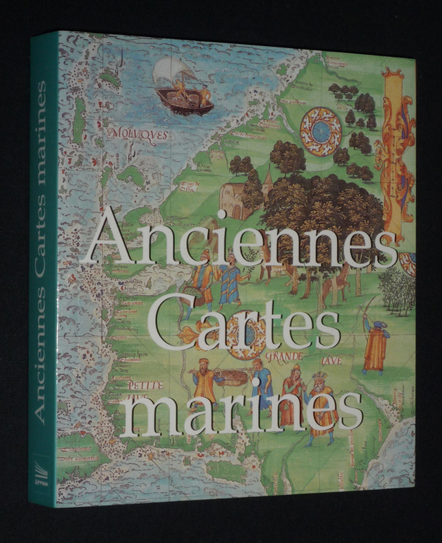
Wigal Donald
Anciennes cartes maritimes
Sirrocco Broché 2006 In-12 (14,8 x 16,2 cm), broché, 255 pages, illustrations en couleurs ; très bon état. Livraison a domicile (La Poste) ou en Mondial Relay sur simple demande.
Bookseller reference : fj1065
|
|
|
Wild World Of Maps, Inc Staff, and Wide World Of Maps
Tucson Metropolitan Street Atlas
Wide World of Maps Incorporated 1999. Unabridged. Spiralbound. Fine. Trade paperback US. Wide World of Maps, Incorporated unknown
Bookseller reference : Alibris.0013442 ISBN : 1887749160 9781887749169
|
|
|
Will Durant; Illustrator-Glossy B&W illust. EP Maps
Life of Greece "the Story of Civilization" Series Part 2 II Two
simon & schuster Pub 1966-01-01. Unknown Binding. Very Good. Nice looking book has minor edge wear.dusk jacket is faded & has tears.Pages are tan and not crisp white. simon & schuster Pub unknown
Bookseller reference : 641110222004
|
|
|
Willett, B. M. . [et al.] (eds.)
Philip's Modern School Atlas
85th edition. Fine hbk bound in glazed pictorial boards. Co-editors, D. Gaylard, L. Prince-Smith, J. Russell, R. Smith, A. Wells. ISBN 0540055549. 21219. eng
|
|
|
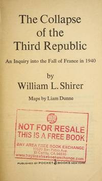
William l. Shirer; Liam Dunne (maps)
The Collapse of the Third Republic: An Inquiry into the Fall of France in 1940
New York NY: Pocket Books July 1971. First Thus. Mass Market PaperBack . Very Good. Pocket mass market edition. Not abridged. Mild shelfwear. Slightly bowed spine. 1116 pages Pocket Books paperback
Bookseller reference : 291173 ISBN : 0671785095 9780671785093
|
|
|
William Napier; et al; Photos & Maps [Illustrator]
Pacific Voyages: The Encyclopedia of Discovery and Exploration
Doubleday & Co. Inc. Garden City 1973-01-01. Hardcover. New. New. In shrink wrap. Looks like an interesting title! Doubleday & Co., Inc., Garden City hardcover
Bookseller reference : Q-038504335X ISBN : 038504335X 9780385043359

|
|
|
WILLIAMS & Co
Articles et Costumes pour Sports et Jeux.
Paris, Williams, Rue Caumartin, 1924. In 8 (115 x 195) de 72 p. Agrafé, couverture illustrée en brun. Excellent état.
Bookseller reference : EYL-175
|
|
|
Williams, Jay. Maps By Richard Edes Harrison
The Battle for the Atlantic. Landmark Books Series No. 87
Random House. Used - Good. Good condition. Acceptable dust jacket. #87. juvenile nonfiction world war ii naval operations A copy that has been read but remains intact. May contain markings such as bookplates stamps limited notes and highlighting or a few light stains. Random House unknown
Bookseller reference : S08OS-01817
|
|
|
Williams, Jay. Maps By Richard Edes Harrison
The Battle for the Atlantic. Landmark Books Series No. 87
Random House 1959. hardcover. Very Good. 8x5x0. Random House hardcover
Bookseller reference : 231102105
|
|
|
Williams, Jay. Maps By Richard Edes Harrison
The Battle for the Atlantic. Landmark Books Series No. 87
Random House. Collectible - Good. First edition copy. Collectible - Good. Good dust jacket. World War 2 Atlantic Ocean Random House unknown
Bookseller reference : S01Q-00484
|
|
|
Williams, Jay. Maps By Richard Edes Harrison
The Battle for the Atlantic. Landmark Books Series No. 87
Random House. Used - Acceptable. Acceptable condition. Good dust jacket. Book 87 in Landmark Series. Juvenile Historical Fiction History United States History A readable intact copy that may have noticeable tears and wear to the spine. All pages of text are present but they may include extensive notes and highlighting or be heavily stained. Includes reading copy only books. Random House unknown
Bookseller reference : SB09E-01354
|
|
|
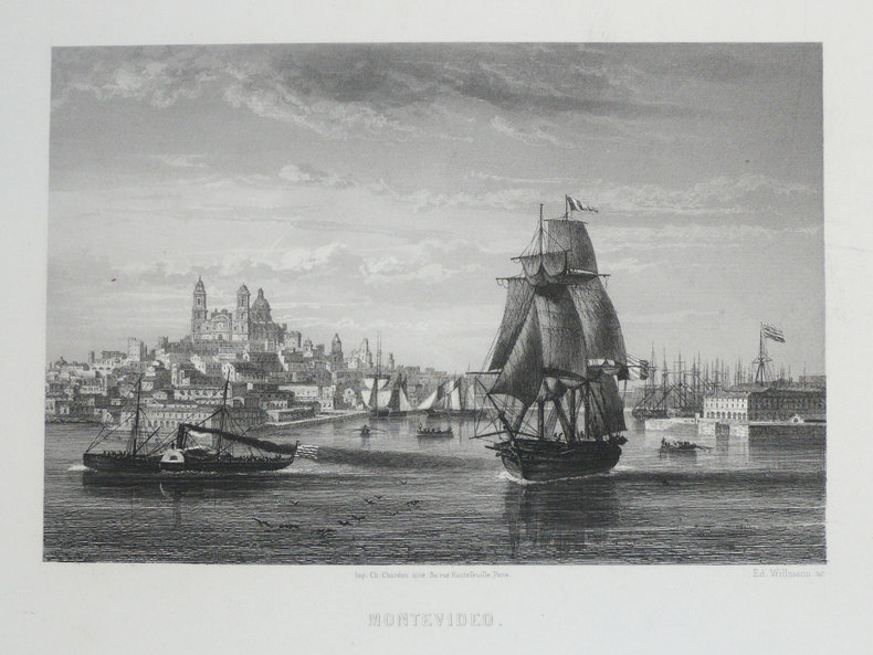
WILLMANN (Edward).
[URUGUAY] Montevideo.
Paris, [circa 1860]. 126 x 168 mm.
Bookseller reference : LBW-1233
|
|
|
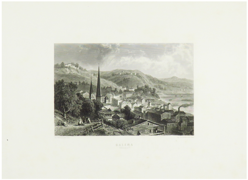
WILLMANN (Edward).
Galena (Illinois).
Paris, [circa 1860]. 131 x 172 mm.
Bookseller reference : LBW-1248
|
|
|
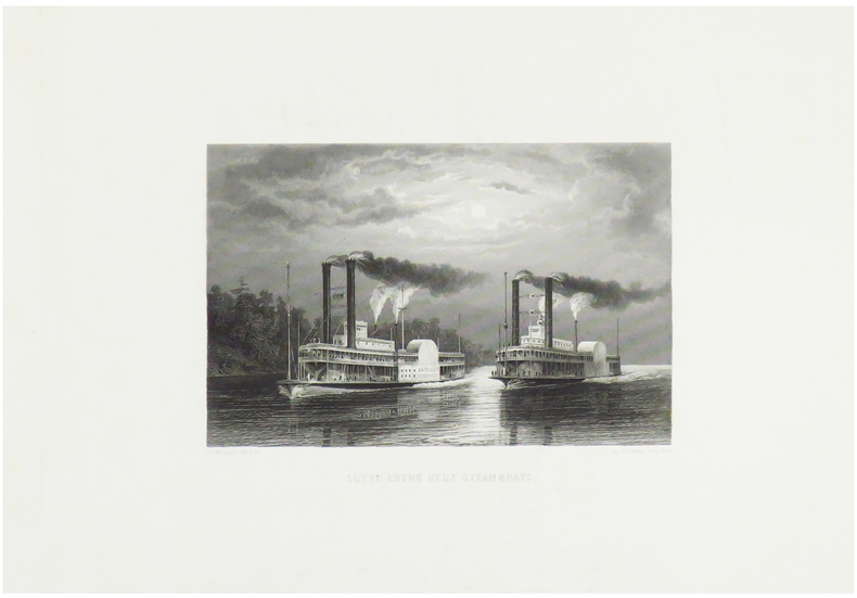
WILLMANN (Edward).
Lutte entre deux steamboats.
Paris, [circa 1860]. 125 x 170 mm.
Bookseller reference : LBW-1249
|
|
|
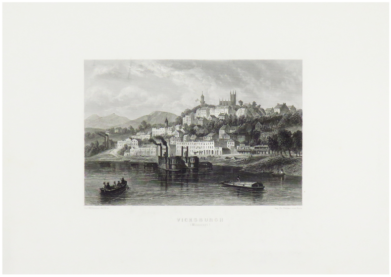
WILLMANN (Edward).
Vicksburgh (Missouri).
Paris, [circa 1860]. 130 x 170 mm.
Bookseller reference : LBW-1247
|
|
|
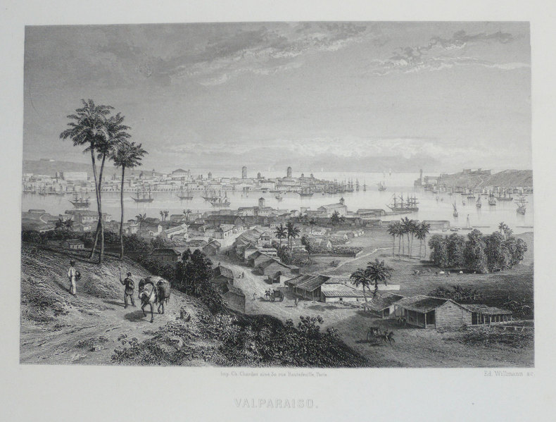
WILLMANN (Edward);
[CHILI] Valparaiso.
Paris circa 1860 126 x 168 mm.
Bookseller reference : LBW-1203
|
|
|
WILLOUGBY Martin
"La carte postale; une histoire illustrée du tournant du siècle à nos jours."
Paris, Bookking International, 1993. 23 x 30, 153 pp., très nombreuses illustrations en couleurs, reliure d'édition carton imprimé + jaquette, très bon état.
Bookseller reference : 73751 ISBN : 287714173
|
|
|
Wills, F. Alex (The Vagabond)
The English Gate (Northumberland)
No marks or inscriptions. No creasing to covers or to spine. A very clean very tight copy with bright unmarked slightly sunned orange cloth boards, rubbing to a small number of page edges and bumping to lower front corner. 242pp. Historical and touring account of the county of Northumberland. Illustrated. Undated ca 1950.

|
|
|
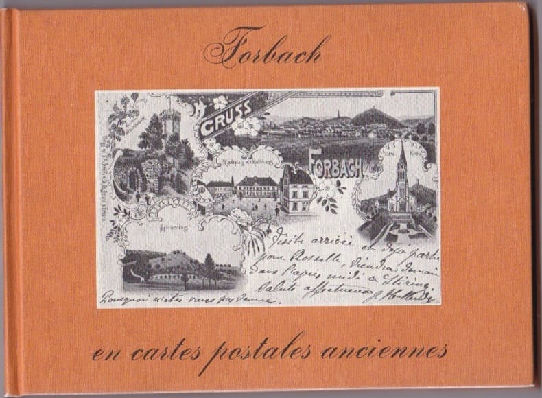
WILMIN H
Forbach En Cartes Postales Anciennes
Pays Bas Bibliotheque Europeenne 1980 In 12 Oblong Non paginé - env. 80 pages - cartonnage editeur illustré - trés nombreuses reproductions de CPA - bel etat
Bookseller reference : RES10L74
|
|
|
WILMIN H
Forbach En Cartes Postales Anciennes
Pays Bas Bibliotheque Europeenne 1980 In 12 Oblong Non paginé - env. 80 pages - cartonnage editeur illustré - trés nombreuses reproductions de CPA - bel etat
Bookseller reference : RES10L74
|
|
|
Wilson, Geoff (Text) and Classon, Bill (Maps)
FISHING VICTORIA'S COASTLINE
South Croydon: Australian Fishing Network. Fine. 2002. First Edition. Paperback. 1865130338 . With colour photographic illustrations and many maps a fine copy. This book is light and postage will be reduced for shipment within Australia. ; 300 x 220mm; 112 pages . Australian Fishing Network paperback
Bookseller reference : 20138 ISBN : 1865130338 9781865130330

|
|
|
Wilson, H. L. & Clayton Jones, H.
Mountain Skylines and Place Names in Llandudno and District
No marks or inscriptions to contents. No creasing to covers. A clean tight booklet with slightly foxed boards, mark to rear (ink ?), rusty staples and no bumping to corners. 24pp. In three parts - 'Guide to the Welsh pronunciation', 'Mountains in the vicinity of Llandudno' and 'Welsh Place Names in Llandudno and District'. Undated ca 1900.

|
|
|
Wilson, Martin Anthony
Unwind by Water in Lakeland
Book in mint unread condition. 132pp. For those who come to the Lake District to unwind and enjoy some time relaxing in a glorious waterside setting. This book tells you the places to go.

|
|
|
Wilson, Robert H. (Editor).
PHILADELPHIA. Official Handbook for Visitors.
128p. Illustrated with numerous photographs, many in color, and maps. 16mo. Original wraps very soiled. PA PAMPH 20_18 BX6
|
|
|
WILSON, Robert Thomas
History Of The British Expedition To Egypt; To Which Is Subjoined A Sketch Of The Present State Of That Country And Its Means Of Defence; Illustrated With Maps And Portraits of Sir Ralph Abercromby
London: T. Egerton, 1803. in-4° , (270x215) , relié demi basane et coins , dos lisse avec pièce de titre et auteur, xxi-387pp , frontispice , 2 tableaux dépliants et 3 cartes dépliantes légèrement coloriées ,quelques rousseurs , déchirure à une carte sans manque ,ex-libris charles Kettaneh, bon exemplaire .
Bookseller reference : PHO-893

|
|
|
Winchester Simon; Wong Cezanne Maps & Charts
Pacific Nightmare: A Third World War In The Far East
Sidgwick & Jackson Ltd. Very Good in Very Good dust jacket. 1992. First Edition; First Printing. Hardcover. 0283061065 . Book and DJ have mild edgewear 4 pages have small wrinkle to fore-edge w/tiny tear to 2 of those pages little bit of very light soiling to page ends; DJ has light toning to flaps little bit of wrinkling to edges 2 small faint moisture marks to interior front edge that doesn't show through; DJ in protective Brodart cover ; 302 pages . Sidgwick & Jackson Ltd hardcover
Bookseller reference : S1933 ISBN : 0283061065 9780283061066

|
|
|
Winsor, Justin; Boston.
MEMORIAL HISTORY OF BOSTON - INLCLUDING SUFFOLK COUNTY, MASSACHUSETTS. 1630-1880. Four Volume Set.
Four Volumes. pp. 596; 577; 691; 713 + Folded two page map of Boston in color, and other illustrations, maps etc. 4to. Original full cloth binding; somewhat worn and stained. XLib. Skidompha Library, Damriscotta, ME. **PRICE JUST REDUCED! NEW ENG 4
|
|
|
Winston Halstead (editor)
Lancashire Magazine : Autumn 1978
No marks or inscriptions. Light creasing to covers. A very clean very tight copy with bright unmarked boards and no bumping to corners. 71pp. Features on Clitheroe and Gisburn, curious Lancashire, Ferries across the Mersey, fashion, leisure, local history.

|
|
|
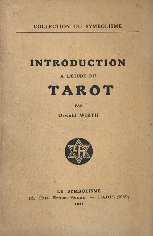
Wirth (Oscar) :
Introduction à l'étude du Tarot.
Paris, Le Symbolisme, 1931 ; in-8, broché ; 49 pp., (3) ff. de table, achevé d'imprimer, le dernier blanc, couverture beige imprimée, nombreuses figures in-texte.
Bookseller reference : 14773
|
|
|
WIRTH Oswald
Le tarot des imagiers du moyen âge. Préface de Roger Caillois.
Paris: Sand et Tchou, 1983 in-8, 377 pages, illustrations, une planche dépliante, bien complet du jeu de 22 cartes dessinées par Michel Siméon in fine. Reliure basane verte, dos à nerfs,, tranches salies, bon état.
Bookseller reference : 1368155
|
|
|
WIRTH Thierry
LA PROVENCE LA COTE D'AZUR A LA BELLE EPOQUE
Bruxelles, SODIM, 1976, 1 vol. in-4, reliure d'éditeur illustrée, de 214 reproductionsde cartes postales,
Bookseller reference : 10968
|
|
|
Wisconsin State Planning Board & Wisconsin Conservation Commission, maps B/W photographs
A Park Parkway and Recreational Area Plan Wisconsin State Planning Board and Conservation Commission
Wisconsin State Planning Board Wisconsin Conservation Commission 1939. 134 pp. foldout map rebound in buckram hardcover ex library covers rubbed several pages lightly creased at top corner or fore edge glue residue to front free endpaper else text clean and binding tight. - If you are reading this this item is actually physically in our stock and ready for shipment once ordered. We are not bookjackers. Buyer is responsible for any additional duties taxes or fees required by recipient's country. Wisconsin State Planning Board, Wisconsin Conservation Commission hardcover
Bookseller reference : ZB783545
|
|
|
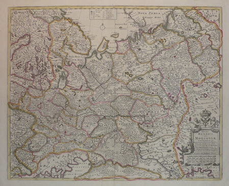
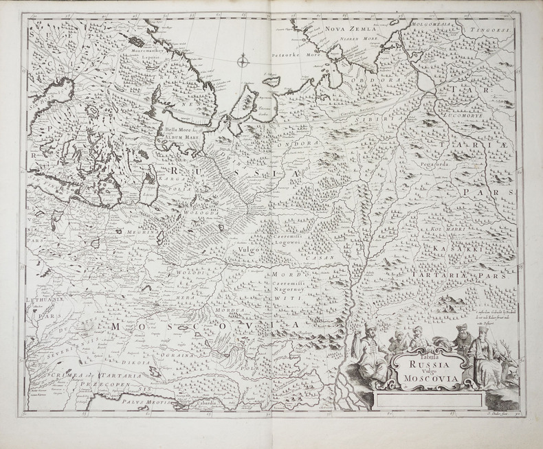
WIT (Frederick de).
[RUSSIE] Imperii Russici, sive Moscoviae.
London, Christopher Browne, [circa 1700]. 450 x 558 mm.
Bookseller reference : LBW04171
|
|
|
WIT (Frederick de).
Tabula Russia vulgo Moscovia.
vers 1700. 450 x 558 mm.
Bookseller reference : LBW-2278
|
|
|
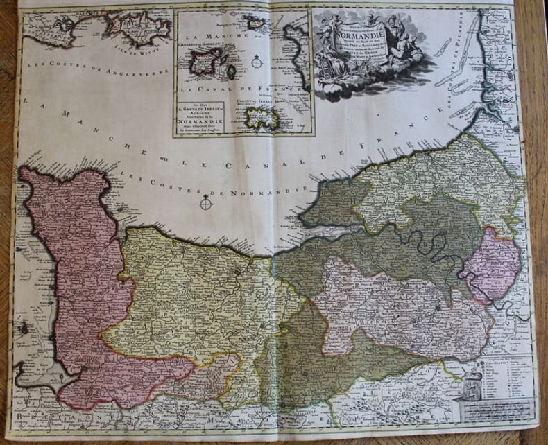
WITT (F. De).
Duché et Gouvernement de Normandie divisé en Haut et Bas en divers Pays et Bailliages avec le Gouvernement General de Havre de Grace.
Amsterdam, F. De Witt avec Privilège des Etats d'Hollandeet de Westfrise, s.d. (ca 1700-1708). Carte de 600 x 525 mm. Baillages mis en couleurs et cartouche central avec les îles anglo-normandes Garnezy, Ierzay et Aurigny. En très bon état, sans marges latérales
Bookseller reference : 22401
|
|
|
Wittemberg:
Wittemberg. "Plan der Action, welche d. 2.Oct. 1760 zwischen einem Kön. Preussischen Corps und einem Corps der Kayseerlichen und Reichs Armee bey Wittemberg vorgefallen." Schlachtenplan von Wittemberg, links mit Legende. Kupferstich mit farbigen Truppenaufstellungen aus "Neues Kriegs-Theater ...", 23. Supplement.
Format: 18 x 29,5 cm. *Leicht gebräunt, insgesamt gut erhalten. Landkarten de
|
|
|
Witzig Roland:
Dolce Vita - étiquette de vin.
Etiquette pour un blanc d'Epesses, domaine Wannaz à Chenaux, 1985.
Bookseller reference : 1901

|
|
|
Witzig Roland:
Witzig - Petite sérigraphie signée.
Lausanne, La Marge. Sérigraphie en noir, au format 11 x 21 cm.
Bookseller reference : 26120

|
|
|
Witzleben, A. von
Deutschlands Militär-Literatur im letzten Jahrzehnt und Übersicht der wichtigsten Karten und Pläne Central-Europas.
Bln., Mittler 1850. VII, 247 S., HLn. m. gldgepr. Rückentit., Kanten leicht bvestoß., Bibl.-Stemp. u. hs. Vermerk am Innentit., schwach stockfl.
Bookseller reference : BIBG0021
|
|
|
Woerl, Joseph Edmund [1803-1865]:
Die Badischen Bäder. Baden, Rippoldsau, Griesbach, Hub, Petersthal, Erlenbad, Antogast, Freiersbach etc. oder Specialkarte der Gegend zwischen Strassburg, Carlsruhe, Offenburg und Freudenstadt. Maßstab 1 : 135 000.
Lithographierte Karte, auf Leinen aufgezogen in 15 Segmenten. 55 x 48 cm, gefaltet: 17 x 12 cm. In Orig.-Halbleinenmappe. *Datierung nach den Angaben zu dem Exemplar der Universitätsbibliothek Basel. Landkarten de
|
|
|
Wolbling, Jutta
Die Wesermarsch von Oben
No marks or inscriptions. Crease to lower corner of soft front cover. Rear cover is sunned stiff card. A very clean very tight copy with no bumping to corners. Single-sided with interleaved tissue. 16pp. Aerial views of Weser Marsh in northern Germany. All text in German.

|
|
|
Woldan, Erich
Die ältesten gedruckten modernen Karten Afrikas.
Wien, Verlag der Österreichischen Akademie der Wissenschaften, 1981. S. 252-257. Mit 8 Taf. (= Veröffentlichungen der Kommission für Geschichte der Mathematik, Naturwissenschaften und Medizin, H. 34 / Sonderabdruck aus dem Anzeiger der phil.-hist. Klasse der Österreichischen Akademie der Wissenschaften, Jg. 118, So. 15). Gr.-8vo. OBrosch.
Bookseller reference : 60980
|
|
|
WOLFE, JAMES.
Sailing Directions for the Lower Shannon and the Lough Derg.
London, Admiralty, 1843 8vo. In recent half cloth with gilt stamp and lettering to front board. Small paper label pasted on to verso front board and two stamps to title-page. Internally fine and clean. 32 pp.
|
|
|
WOLFE, JAMES.
Sailing Directions for the Lower Shannon and the Lough Derg.
London, Admiralty, 1843 8vo. In recent half cloth with gilt stamp and lettering to front board. Small paper label pasted on to verso front board and two stamps to title-page. Internally fine and clean. 32 pp.
Bookseller reference : 57129
|
|
|
WOLFF (Jeremias).
[BERNE] Bern in der Schweitz.
Augsbourg, Hæred Jer. Wolffÿ, [circa 1720]. En 2 feuilles jointes formant une vue de 0,34 x 1,05 m.
Bookseller reference : LBW-8838

|
|
 Receive by email
 Download as PDF document
 RSS feed


