|
Wade, Frank
A Midshipman's War : A Young Man in the Mediterranean Naval War, 1941-1943
256 pages. Index. Bibliography. Black and white illustrations. "The author's first hand account is one of continous activity with great detail on all the actions fought and sinkings which occured. This is truly an historic book supported by maps, photographs and extensive data with a full index. There is much anecdotal material including an interview with the German submarine commander who sank the Barham and is now a resident of Canada." - from dust jacket. Book practically as new. Dust jacket in beautiful condition and now in archival-grade Brodart protective cover. Its spine is a different shade of green than that of the front and back panels. We do not know if this is by design or the result of sunning. Gift quality. Excellent copy. Book

|
|
|
WAGNER Mattaheus (1648 - LIpsia 1694)
Roma
Acquaforte e bulino, circa 1690. "In alto al centro lo stemma SPQR sormontato da una corona. Il prototipo iniziale per questo tipologia di panorami è identificabile nel panorama inciso dal Silvestre nel 1642 (si vedano tra l'altro i campanili di San Pietro all'epoca appena costruiti ed immediatamente dopo demoliti per ragioni statiche) e dunque raffigura Roma alla metà del '600. Gli edifici sono poco riconoscibili ed il Tevere segue un errato percorso sotto Trinità dei Monti. La stampa mostra un primo piano con colline ed alberi in controluce senza personaggi, e una legenda di 12 voci. Il nome dell'autore non è scritto sull'incisione ma solo sull'opera che non è stato comunque possibile reperire; non è chiaro neppure se il Wagner sia l'autore o l'editore. Incisa prima del 1694, anno in cui Wagner morì. Secondo alcuni studiosi l'editore potrebbe essere J. Wollf e la data di pubblicazione spostata a circa al 1710" (cfr. Marigliani p. 198). Buono stato di conservazione. Rara. Etching and engraving, circa 1690. In the top centre the SPQR coat of arms surmounted by a crown. The initial prototype for this type of panorama is identifiable in the panorama engraved by Silvestre in 1642 - see among other things the bell towers of St. Peter's that had just been built and immediately afterwards demolished for static reasons - and therefore depicts Rome in the mid 17th century. The buildings are hardly recognisable and the Tiber follows a wrong path under Trinità dei Monti. The print shows a foreground with hills and trees against the light without any characters, and a key-legend of 12 items. The name of the author is not written on the engraving but only on the title page, which could not be found anyway; it is not clear either if Wagner is the author or the publisher. Engraved before 1694, the year Wagner died. According to some scholars the publisher could be J. Wollf and the date of publication moved to around 1710" (cf. Marigliani p. 198). Good state of preservation. Rare. C. Marigliani, "Le Piante di Roma delle collezioni private", tav. 103.

|
|
|
Wagner, David L. ; California ; Division of Mines and Geology ; California.; Department of Conservation.
Geologic map of the San Francisco-San Jose quadrangle, 1990
Four large loose multi-color folded multi-paneled maps, 81 x 149 cm, and a four-page introductory pamphlet, in original printed envelope 31 x 25 cm. Uncommon. Contents: Sheet 1. Geologic map of the San Francisco-San Jose quadrangle, California, 1:250,000 / compilation by D.L. Wagner, E.J. Bortugno, and R.D. McJunkin -- sheet 2. Geologic map explanation of the San Francisco-San Jose quadrangle, California, 1991 -- sheet 3. Index to geologic maps used in compilation of the San Francisco-San Jose quadrangle, California, 1:250,000 -- sheet 4. Location map of rock samples dated radiometrically, San Francisco-San Jose quadrangle, California, 1:250,000 / compilation by T.A. Lindquist, J.D. Morgenthaler, and E.J. Bortugno. -- sheet 5. Map showing recency of faulting, San Francisco-San Jose quadrangle, California, 1:250,000 / compilation by E.J. Bortugno, R.D. McJunkin, and D.L. Wagner. || Geology -- California -- San Francisco Region -- Maps. Geology -- California -- Maps. Geology, Stratigraphic -- Maps. GÈologie -- …tats-Unis -- Californie (…tats-Unis) -- Cartes. Geology. Geology, Stratigraphic.
|
|
|
Walch, Johannes
General Charte über die sämtlich Königlich Preussischen Staaten nach astronomischen Beobachtungen. [Altkolorierter Original-Kupferstich / original colored copper engraving].
o.J. Johann Walch, geboren am 25. November 1757 in Kempten, gestorben am 23. März 1815 in Augsburg. Deutscher Maler, Zeichner, Kupferstecher, Kartograph und Verleger. [4 Warenabbildungen]
Bookseller reference : 12030DB

|
|
|
Walcott, Charles D. (Secretary Of The Smithsonian Institution); Holmes, W. H. (Chief); B&W Photographs/Maps [Illustrator]
Twenty-Ninth Bureau of American Ethnology to the Secretary of the Smithsonian Instittuion 1907-1908: Tewa Indians
Smithsonian Institution 1916-01-01. Hardcover. Good. 636 pages with 21 plates 31 maps 1 diagram and index. Quarto 11 1/2" x 8 1/4" issued in olive green with gilt lettering to spine and pictorial to cover. Previous owner's name and address is on inside front board. Red price number on fep. Hinges cracked and pages yellowing. Corners worn to board and bent. Worn edges and wavy cloth on boards. Inside pages clean and binding is tight. Smithsonian Institution hardcover
Bookseller reference : b2-4-3
|
|
|
Waldburger, A
Plan von Ragaz mit Spaziergängen und den Anfängen der Wegmarkierung.
Ragaz 1909. 1 mehrfarb. Faltplan m. Textteil. 18x12 cm (35x45 cm). [2 Warenabbildungen]
Bookseller reference : 6413

|
|
|
Waldburger, A
Ragaz und Umgebung.
Ragaz 1910. Karte mit vollst. Wegmarkierung. 1:25 000. Landkarte 55x59 cm, Faltmaß 19x12 cm. [2 Warenabbildungen]
Bookseller reference : 6414

|
|
|
Waley, Arthur; maps, Endpaper
THE LIFE AND TIMES OF PO CHU-I 772-846 A.D.; THE LIFE AND TIMES OF PO CHU-I 772-846 A.D.
George Allen & Unwin. Very Good. 1949. First Edition. Hardcover. 8vo 8" - 9" tall . George Allen & Unwin hardcover
Bookseller reference : 158170
|
|
|
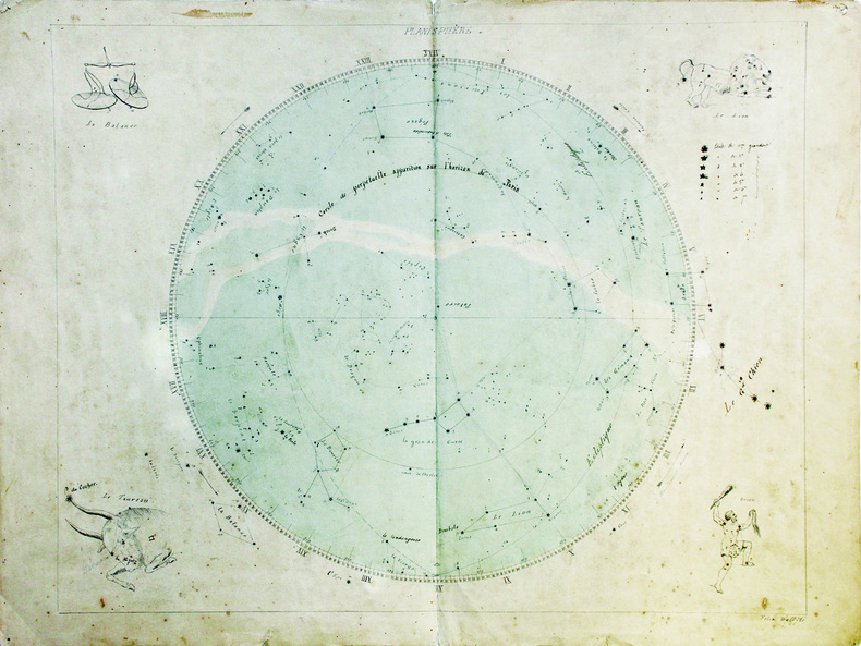
WALFFLÉ (Félix).
Planisphère.
[fin du XVIIIe siècle]. 43,5 x 55 cm, sur une feuille de 48 x 63,5 cm.
Bookseller reference : LBW-6627
|
|
|
Walk Maps By Tim Locke.
10 Good Walks. GUIDE.
London UK.: Consumers' Association 1992. This is the first edition of this edition. This booklet contains material first published in 1990 in Holiday Which Town and Country Walks Guide. Natural brown stained staple marks. This book will be POSTED AT OUR STANDARD RATES FULLY INSURED UK ONLY . Please email for further details. OFFERED FOR SALE BY A FULL-TIME STOCKHOLDING CAREER BOOKSELLER WHO TELLS YOU WHO THEY ARE AND WHAT THEIR TELEPHONE AND ADDRESS CONTACT DETAILS ARE! POSTED AT OUR STANDARD RATES FULLY INSURED! UK ONLY. FEEL FREE TO E-MAIL FOR PHOTOGRAPHS AND FURTHER DETAILS. Not Signed or Inscribed. Pictorial Card. Very Good AVERAGE/No Jacket. Illus. by Map Illustrations Throughout. 12mo - over 6¾" - 7¾". Guide. Consumers' Association Hardcover
Bookseller reference : 573493
|
|
|
WALKER J & C. ENGRAVERS.
Turkey containing the provinces in Asia Minor.
London.: Society for the Diffusion of Useful Knowledge. Baldwin & Cradock. 1830. Engraved map wth outline hand colour 29.7 x 42 cm relief shown in hachures key to abbreviations including "Ancient Ruins" the west and east extremities attactively engraved to burst through the border original folds map with occasional spotting more pronounced at the lower corner edges a little ragged small chip to the inner margin no loss to the map manuscript pagination in the lower corner but in good condition. . Society for the Diffusion of Useful Knowledge. Baldwin & Cradock. unknown
Bookseller reference : 175250

|
|
|
WALKER'S County Maps.
Walker's Monmouthshire.
1839. Longman Rees and Co. 1839. Early Edition. Hardback. No DW. Brown textured cloth. 9cm x 12.5cm. Linen-backed fold-out map in colour 35cm x 42cm . Ownership signature to inside cover. A lovely copy. hardcover
Bookseller reference : 78212
|
|
|
Walker, J und C.:
Dorsetshire. (County map).
Engraved map, hand-coloured in outline, dissected into 15 sheets. Mounted on linen, folding into blue cloth covers, original printed label. Dimensions: 340 x 410 mm. (13 x 16 inches). Landkarten de
|
|
|
Walks and maps compiled by Joan Deacon
Isle of Wight: Second 12 Favourite Walks second series
Isle of Wight Great Britain: Isle of Wight Area of the Ramblers' Association 1989. First Edition First Printing . Soft cover. Good. 8vo - over 7¾ - 9¾" tall. drawings by Iris Evans. Illustrated stapled booklet with some fading on the cover. <br/> <br/> Isle of Wight Area of the Ramblers' Association paperback
Bookseller reference : 075062
|
|
|
Walks and maps compiled by Joan Deacon
Isle of Wight: Second 12 Favourite Walks Second Series
Isle of Wight Great Britain: Isle of Wight Area of the Ramblers' Association 1989. First Edition First Printing . Soft cover. Good. 8vo - over 7¾ - 9¾" tall. Drawings by Iris Evans. Stapled booklet. Dust spotting and fading on cover. <br/> <br/> Isle of Wight Area of the Ramblers' Association paperback
Bookseller reference : 074611
|
|
|
Walks and maps originally compiled by Joan Deacon, edited by David Howarth
Twelve Favourite Walks on the Isle of Wight
<p>United Kingdom: Published for the Isle of Wight Ramblers by Island Tourist Products Limited 2017. Revised Edition . Soft cover. New. 8vo - over 7¾ - 9¾" tall. Stapled booklet with 12 walks described with map for each maps reproduced from the Ordnance Survey <br /><br /></p> Published for the Isle of Wight Ramblers by Island Tourist Products Limited paperback
Bookseller reference : 089179 ISBN : 1906296103 9781906296100
|
|
|
Wallis Helen Keeper of Maps British Library
The Voyage of Sir Francis Drake Mapped in Silver and Gold
Friends of Bancroft Library 1979. Very Good. Wallis Helen Keeper of Maps British Library. The Voyage of Sir Francis Drake Mapped in Silver and Gold. Berkeley: Friends of Bancroft Library 1979. 26pp. 8vo. Blue wraps. Book condition: Very good. Friends of Bancroft Keepsake #27. Friends of Bancroft Library paperback books
Bookseller reference : UWALVOY00LNW
|
|
|
Wallis, Geoff & West, Ben
The Rough Guide to Family Fun in Ireland
No marks or inscriptions. No creasing to covers or to spine. A very clean very tight copy with bright unmarked boards and no bumping to corners. 172pp.

|
|
|
Wally Koval
ACCIDENTALLY WES ANDERSON : POSTCARDS
, Orion (Hachette), 2022 Card Book, ENG, 26 postcards in colour, 160 x 115 mm, NEW, from different places in the world,. ISBN 9781399608725.
Bookseller reference : 60288

|
|
|
Wally Koval
ACCIDENTALLY WES ANDERSON : POSTCARDS
Card Book, ENG, 26 postcards in colour, 160 x 115 mm, NEW, from different places in the world,. ISBN 9781399608725. 26-POSTCARD SET featuring 26 full-colour photographs from the bestselling Accidentally Wes Anderson book, based on the Instagram phenomenon. FOR FANS OF WES ANDERSON and Wally Koval alike, these postcards pay homage to the director's unique style with photographs from the most interesting locations spotted all around the world. STURDY PAD-BOUND BOOK allows for easy browsing and detachment of each postcard individually. Accidentally Wes Anderson: The Book invited us to journey to more than 200 real-life "Andersonian" locations around the world. From the tasteful technicolour of the Venetian Lagoon to Hong Kong's Choi Hung Estate (aptly named after the word for "rainbow" in Cantonese), the collection is an irreverent reverie for the armchair traveller, drenched in nostalgia, whimsy and charm. Now wherever you are in the world - home or away - with this beautiful postcard set you can send a little piece of Wes Anderson's unique aesthetic to your loved ones, complete with your own 'wish you were here' note.

|
|
|
WALTER, Franois (textes). - ZANOLI, Marco (cartes).
Atlas historique de la Suisse. L'histoire suisse en cartes. 2e Edition.
Neuch‰tel : Editions Livreo-Alphil 2021. 245x285mm. cartes en couleurs reliure d'ÂŽditeur. Format oblong. TrÂs bel exemplaire. 1404 Editions Livreo-Alphil unknown
Bookseller reference : 106916
|
|
|
Walthéry François:
Vestiaire.
[Khani], sans date. Planche sur plastique, parfois annoncée comme "plaque de porte", au format 11 x 25 cm.
Bookseller reference : 6245

|
|
|
Walvin, James
The Slave Trade (History Files)
Book is in excellent condition, as new. Binding is solid and square, covers have sharp corners, exterior shows no blemishes, text/interior is clean and free of marking of any kind. 144 pages, heavily illustrated, included unopened pack of "facsmile documents" in back pocket. 145 illustrations, 90 in color, 10 facsimile documents.
|
|
|
WARD C.S:
The Isle of Wight. With notes for geologists & cyclists.
London, Dulau & Co, 1895. In-8 de X-[4]-96 pages, pleine percaline rouge d'éditeur ornée à froid, dos lisse. Coins supérieur du second plat frotté.
Bookseller reference : 2308
|
|
|
Ward, Bob; maps by Ann Ward
Mountain Biking in tthe Northern Sierra - Volume Two: Grouse Ridge and the Excelsior District
Sacramento CA: Bobo Ptroductions 1990. Not stated presumed 1st edition. PB in b/w-photo wraps saddle-stapled. Fine unmarked no spine creases. More great mountain bike getaways mapped and described b/w photos. Bright tight clean unused PB copy. <br/><br/>5-1/2 x 8-1/2 86 pp b/w maps & photos. Bobo Ptroductions paperback
Bookseller reference : 42329
|
|
|
Ward, Greg, Illustrated by Maps
The Rough Guide to the Big Island of Hawaii
E Rutherford New Jersey U.S.A.: Rough Guides 1995 Rough Guides 1996 reprint paperback. a BRAND NEW BOOK. Full refund if not satisfied. 24 hour despatch. Soft cover. New/No Jacket. E Rutherford, New Jersey, U.S.A.: Rough Guides paperback
Bookseller reference : amis120 ISBN : 185828158X 9781858281582

|
|
|
Ward, Greg
The Rough Guide to Brittany & Normandy
No marks or inscriptions. No creasing to covers or to spine. A very clean very tight copy with bright unmarked boards, very slight rub to front and no bumping to corners. 462pp. Travel guide to Northern France.

|
|
|
Warner, Judith and Simon
The South Pennines and the Bronte Country
Book in virtually mint condition. Dust jacket not price clipped or marked or torn with slight creasing to upper edge. 64pp. Ten pages of introduction followed by beautiful photographs of the West Yorkshire area on quality art/photographic paper and accompanied extensive captions..

|
|
|
Warnke, James R. & Maps and Photos by The Author
GHOST TOWNS OF FLORIDA
Star Publishing Co. Very Good. 1971. Reprint. Paperback. 104 pages . Star Publishing Co. paperback
Bookseller reference : 66750

|
|
|
WASHBURN, Wilcomb E. (1915-1997).
Representation of unknown lands in the XIV, XV and XVI Century Cartography.
Coimbra, 1969 [Separata da "Revista da Universidade"]. Folio; 20 pp. Cubiertas originales.

|
|
|
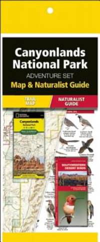
Waterford Press; Maps, National Geographic
Canyonlands National Park Adventure Set: Travel Map & Wildlife Guide
new. unknown
Bookseller reference : 23874490-n ISBN : 1583559647 9781583559642
|
|
|
Waterford Press; Maps, National Geographic
Canyonlands National Park Adventure Set: Travel Map & Wildlife Guide
like new. unknown
Bookseller reference : 23874490 ISBN : 1583559647 9781583559642
|
|
|
Waterford Press (Corporate Author)/ National Geographic Maps (Corporate Author)
Death Valley National Park Adventure Set: Map & Naturalist Guide
Waterford Pr 2015. Paperback. New. paperback/map edition. 14 pages. 9.25x4.50x0.25 inches. Waterford Pr paperback
Bookseller reference : 1-1583559086 ISBN : 1583559086 9781583559086

|
|
|
Waterford Press (Corporate Author)/ National Geographic Maps (Corporate Author)
Glacier Bay National Park & Preserve Adventure Set: Map & Naturalist Guide
Waterford Pr 2015. Paperback. New. paperback/map edition. 14 pages. 10.50x4.75x0.25 inches. Waterford Pr paperback
Bookseller reference : 1-1583559280 ISBN : 1583559280 9781583559284

|
|
|
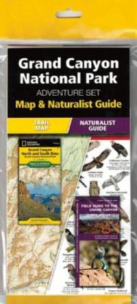
Waterford Press (Corporate Author)/ National Geographic Maps (Corporate Author)
Grand Canyon National Park Adventure Set
Waterford Pr 2015. Paperback. New. paperback/map edition. 14 pages. 9.25x4.50x0.25 inches. Waterford Pr paperback
Bookseller reference : 1-1583559108 ISBN : 1583559108 9781583559109
|
|
|
Waterford Press (Corporate Author)/ National Geographic Maps (Corporate Author)
Great Smoky Mountains National Park Adventure Set: Map & Naturalist Guide
Waterford Pr 2015. Paperback. New. paperback/map edition. 14 pages. 9.25x4.75x0.25 inches. Waterford Pr paperback
Bookseller reference : 1-1583559124 ISBN : 1583559124 9781583559123

|
|
|
Waters, Frank; Fechin, Nicolai (illus.); Annand, George (maps)
The Colorado
New York / Toronto: Rinehart & Company 1946. First Edition. Hardcover. Fine/Very Good. Part of "The Rivers of America" series edited by Hervey Allen and Carl Carmer. Cloth; illustrated dust jacket. With b/w and color illustrations and maps. Spine tips very lightly rubbed otherwise book is fine. Dust jacket very lightly rubbed a little scuffed along the edges; spine a bit sunned; VG not price-clipped presents nicely in mylar. <br/><br/> Rinehart & Company hardcover
Bookseller reference : GK2103
|
|
|
Watson, D.; Color Plates, Drawings, Maps [Illustrator]
Hen Harrier
T & A. D. Poyser 1977. hardcover. Very Good. 9x6x1. T. and A. D. Poyser Pitman Press; Berkhamsted 1977. Hardcover. A Very Good blue cloth binding with gilt lettering on spine binding sturdy and intact some discoloration/sunning along board and spine edges dent bottom front board edge trace scattered foxing top text block edge some age toning to pages previous owner handwritten ink name top front free endpaper in a Very Good some handling/scuff marks to panels mild edge/corner wear spine fade couple of faint creases bottom front flap Mylar protected Dust wrapper. A nice and clean copy. 8vooctavo or approx. 6 x 9 inches 307pp. appendix bibliography tables indexed b&w illustrations. We pack securely and ship daily with delivery confirmation on every book. The picture on the listing page is of the actual book for sale the glare in the photograph is from the Mylar. Additional Scans are available for any item please inquire. T & A. D. Poyser hardcover
Bookseller reference : SKU1037248 ISBN : 0856610151 9780856610158

|
|
|
Watson, D.; Color Plates, Drawings, Maps [Illustrator]
Hen Harrier
T & A. D. Poyser 1977-01-01. 1st Edition. Hardcover. Very Good/Good. 9x6x1. THE Author has made a study of the Hen Harrier over many years and his field notes and sketch book of this exceptional bird of prey go back to the 1940's. The book opens with the world distribution of the harrier family then there is a fuller treatment of the Hen Harrier in Europe and North America the Marsh Hawk its history and present status. Further chapters detail hunting methods and prey selection the breeding cycle migration and distribution. The Jacket has a clear protective cover on it. T & A. D. Poyser hardcover
Bookseller reference : FF0775 ISBN : 0856610151 9780856610158

|
|
|
Watson, Ken W. (Signed)
The Rideau Route: Exploring the Pre-Canal Waterway
Signed, without inscription, by author upon title page. 146 pages. Bibliography. "Takes the reader on a 1783 canoe trip along the Rideau Route, revealing the landscape as it appeared prior to any European settlement. Transcriptions and maps of Lt. French's 1783 survey, as well as those of Lt. Joshua Jebb in 1816 and Samuel Clowes in 1823-24, are included as first hand accounts of the route. This newly revealed pre-canal engineering achievement will allow readers to better understand and appreciate the enormous engineering achievement of the Rideau Canal. Profusely illustrated with maps and period paintings." - from back cover. Clean and unmarked with light wear. A quality copy. Book

|
|
|
WATTS, E. J. M. with illustrations and maps by SOUTER, D. H
STORIES FROM AUSTRALIAN HISTORY
William Brooks & Co. Sydney 1928. 224 pp tinted end-papers b&w illustrations pen marks on upper board damp stained else good copy in papered boards with blue cloth spine. . Third edition. A 'Brooks's Australian School Series' edition. William Brooks & Co., Sydney, 1928 hardcover
Bookseller reference : 227456
|
|
|
WAUTERS, A. J.
Map of the Independent State of the Congo.
New York.: Hunt & Eaton. Circa1893. Printed colour map 24 x 28 cm four thumbnail inset maps: Banana; Boma; Matadi & Environs; Stanley Pool named for the explorer; and below a lozenge inset of the road from Matadi to Leopoldville marginal toning and small edge tears one corner creased but in very good condition and on the verso explanatory text and line engravings in two columns for this map and partial description for the previous entry for the Suez Canal from Hunt & Eaton's school atlas published in 1893. . (Hunt & Eaton). unknown
Bookseller reference : 175715
|
|
|
Wavell Gen Sir Archibald; 15 maps/plans 14 Pp Photos Illustrator
Allenby: A Study in Greatness
Oxford Univ Press 1941-01-01. Hardcover. Good. No dust jacket. Cloth boards have fading of color to the top edge and spine. Clean has a good binding no marks or notations. Oxford Univ Press hardcover
Bookseller reference : 197431
|
|
|
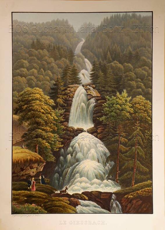
Weber, Lukas (1811-1860)
Le Giessbach.
O.O., um 1935. Altkolorierte Aquatinta von Lukas Weber. Bildgrösse: 24,8 x 17,3 cm. Blattgrösse: 28,3 x 20,2 cm. + Wichtig: Für unsere Kunden in der EU erfolgt der Versand alle 14 Tage verzollt ab Deutschland / Postbank-Konto in Deutschland vorhanden +, Abb.
Bookseller reference : 619DG

|
|
|
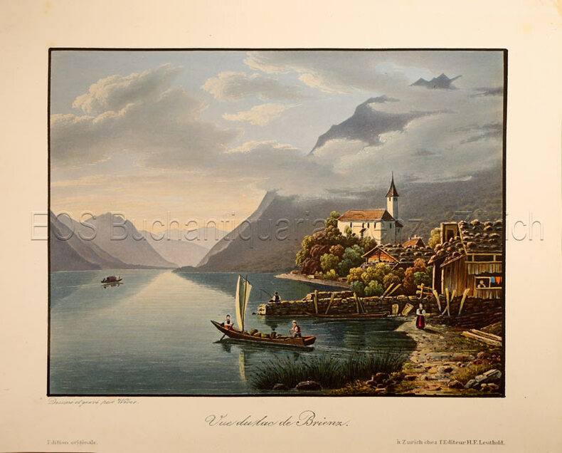
Weber, Lukas (1811-1860)
Vue du lac de Brienz.
Zürich, H. F. Leuthold, um 1840. Altkolorierte Aquatinta von Lukas Weber. Bildgrösse: 13 x 17,3 cm. Blattgrösse: 17,1 x 21,5 cm. + Wichtig: Für unsere Kunden in der EU erfolgt der Versand alle 14 Tage verzollt ab Deutschland / Postbank-Konto in Deutschland vorhanden +, Abb.
Bookseller reference : 781CG

|
|
|
Weber, Lukas (1811-1860):
Le Giessbach.
O.O., um 1935. Altkolorierte Aquatinta von Lukas Weber. Bildgrösse: 24,8 x 17,3 cm. Blattgrösse: 28,3 x 20,2 cm.
Bookseller reference : 619DG
|
|
|
Weber, Lukas (1811-1860):
Vue du lac de Brienz.
Zürich, H. F. Leuthold, um 1840. Altkolorierte Aquatinta von Lukas Weber. Bildgrösse: 13 x 17,3 cm. Blattgrösse: 17,1 x 21,5 cm.
Bookseller reference : 781CG
|
|
|
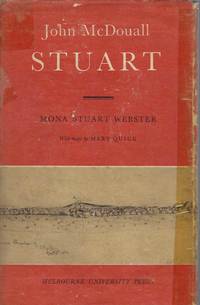
Webster, Mona Stuart; Maps by Mary Quick
John McDouall Stuart
Melbourne University Press 1958 First Edition. Hardcover in Dustjacket. Very Good . First Edition. 319 pages : illustrations ; 23 cm. In protective cover some rubbing to jacket. #031121Biographical account of Stuart; details of his expeditions into central and northern Australia.Stuart John McDouall 1815-1866.    Settlement and contacts - Explorers.    Northern Territory -- Discovery and exploration.    South Australia -- Discovery and exploration.    South Australia - West SA SH53 SI53    South Central Northern Territory NTJohn McDouall Stuart often referred to as simply ""McDouall Stuart"" was a Scottish explorer and one of the most accomplished of all Australia's inland explorers. Stuart led the first successful expedition to traverse the Australian mainland from south to north and return through the centre of the continent. Elizabeth's Bookshops have been one of Australia's premier independent book dealers since 1973. Elizabeth's family-owned business operates four branches in Perth CBD Fremantle WA and Newtown NSW. All orders are dispatched within 24 hours from our Fremantle Warehouse. All items can be viewed at Elizabeth's Bookshop Warehouse 23 Queen Victoria Street Fremantle WA. Hardcover in Dustjacket Very Good Melbourne University Press hardcover
Bookseller reference : 63440
|
|
|
Wedgwood, Iris
Northumberland and Durham
192 pages including index plus 7 additional pages of maps. Illustrated with sixty drawings and twenty-four photographs reproduced in photogravure. A book of the beauty and legend of the North - of the most perfect and unspoiled countryside in England. Average wear. Average bumping and some fading to boards. Bright gilt lettering upon spine. Binding intact. Former owner's signature upon front endpaper. Book
|
|
|
WEIGEL (Christoph).
Mesopotamiæ, Assyriæ et Babyloniæ tabula.
Nuremberg, [circa 1720]. 312 x 398 mm ; montée sur toile.
Bookseller reference : LBW-8790

|
|
 Receive by email
 Download as PDF document
 RSS feed


