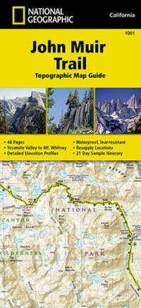
•Waterproof •Tear-Resistant •Topographic Map Guide National Geographic's Map Guide of the John Muir Trail is an indispensable tool for navigating one of the most famous trails in the United States. Expertly researched and created in partnership with local land management agencies this product provides detailed topographic maps interesting history a waypoint table information about resupply and bear safety and key points of interest you will encounter along the trail. Formatted to meet your needs while navigating this breathtaking and remote trail the maps within the guide are one-inch-equals-one-mile 1:63360 making it easy to calculate distances. Each map page has a trail profile that shows the elevation changes you will encounter. Also the John Muir Trail is highlighted and centered on each page so you can easily track your progress. The maps start at the northern terminus in Yosemite Valley and progress along the ridge of the Sierra Nevada past Devils Postpile and end at the highest point in the lower 48 on the top of Mount Whitney. Along the way you will pass through; Yosemite National Park Ansel Adams Wilderness Devils Postpile National Monument John Muir Wilderness Kings Canyon National Park and finally Sequoia National Park and Mount Whitney. All proceeds from the purchase of National Geographic maps help support the Society's vital exploration conservation scientific research and education programs. Download the GPX file of landmarks along the John Muir Trail. These landmarks match the ""Landmarks and Waypoints"" page in the John Muir Trail Topographic Map Guide.JohnMuirTrail.gpx unknown
Bookseller reference : BIBUP61025-A31584 ISBN : 1566956897 9781566956895
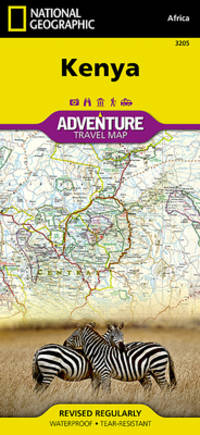
National Geographic's Kenya AdventureMap is designed to meet the unique needs of adventure travelers with its durability and accurate information. Each folded map provides global travelers with the perfect combination of detail and perspective highlighting the areas terrain and best locations for adventure activities like snorkeling surfing fishing and more. AdventureMaps include hundreds of points of interest that highlight diverse and unique destinations within the country. The map includes the locations of thousands of cities and towns with a user-friendly index plus a clearly marked road network complete with distances and designations for major highways main roads and tracks and trails for those seeking to explore more remote regions. AdventureMaps are printed in the United States on a durable synthetic paper making it waterproof tear-resistant and tough capable of withstanding the rigors of international travel. The map is two-sided and can be folded to a packable size of 4.25 x 9.25; unfolded size is 26 x 38. Net proceeds from the sale of this map go to support the nonprofit mission of the National Geographic Society. Key Features: Waterproof and tear-resistant Detailed interpretive information and local travel tips Detailed topography complete with activity symbols ideal for exploring the country City overview maps Hundreds of points of interest including the location of World Heritage sites national parks and nature reserves aboriginal settlements and protected lands mines archeological sites wildlife parks and more Thousands of place names Important travel aids including airports lighthouses ferry routes and rail lines Developed in cooperation with local agencies Updated regularly to ensure accuracy unknown
Bookseller reference : BIBUP61025-A21159 ISBN : 1566956188 9781566956185
National Geographic Maps. New. BRAND NEW GIFT QUALITY! NOT OVERSTOCKS OR MARKED UP REMAINDERS! DIRECT FROM THE PUBLISHER! National Geographic Maps unknown
Bookseller reference : OTF-S-9781566956185 ISBN : 1566956188 9781566956185
 Receive by email
 Download as PDF document
 RSS feed