|
[Maps]
Fiji Road Map
Fiji Times & Herald. Fiji. Loose Leaf. Very Good. Condition: Very good.Tourist map of Fiji. A list Some Viti Levu Points of Interest is keyed to the main map. Smaller maps on reverse of Suva Sigatoka Nadi Ba and Lautoka. 22.5 inches x 33.5 inches. no > Illustrator: B/w illus. > Language: English > Size: 22.5 x 33.5 > Media/Binding: Unbound Fiji Times & Herald., Fiji unknown
Referentie van de boekhandelaar : CORV-BBP-14822
|
|
|
[Maps]
Huahine Polynesie Francaise
Unknown. Loose Leaf. Very Good. Minor creases o/w very good. 1955. c. 23 in x 19.5 in folding map two-color 1/40000 scale with topographic features at 20m contour. > Language: English > Size: 23 in x 19.5 in > Media/Binding: Unbound Unknown unknown
Referentie van de boekhandelaar : CORV-BBP-16108
|
|
|
[MAPS]
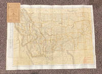
Indexed Pocket Map: Tourists' and Shippers' Guide to Montana
Chicago & New York: Rand McNally & Co 1920. 12mo. 32 pp text; large color folding map 20 1/2" x 27 1/2"; printed on both sides. The front side shows railroads electric lines counties cities towns villages post offices lakes rivers etc. The verso shows the Montana automobile road map. Montana is home to two of the country's most beautiful and iconic National Parks - Yellowstone and Glacier. Printed stiff brown wrappers in fine condition; 3 short closed tears along lower edge of map. Rand McNally & Co unknown
Referentie van de boekhandelaar : 20799
|
|
|
[Maps]
Maps of the Trust Territory of the Pacific Islands
Unknown 1965. Plastic Comb. Good. Comb-bound 4to. High Commissioner Trust Territory of the Pacific Islands. No date. Eight foldout maps; the first of the nine appears to be missing. A large scale map of the territories is followed by maps of the individual groups - Palau Yap Truk Marshalls and Marianas. Islands on the maps are located centered to the map scale but the outlines are enlarged for visibility. No features on the maps but many have population figures from 1965. Plate 1 missing front cover 3/4 detached. Unknown unknown
Referentie van de boekhandelaar : CORV-BBP-16238
|
|
|
[Maps]
Papua New Guinea Robinson's Runaway Series
Runaway Publications. Dee Why Australia. Loose Leaf. Very Good. Very good. No date. C.35 in x 24.5 in folding map for travellers. Shows major roads and towns. > Language: English > Size: 35 in x 24.5 in > Media/Binding: Unbound Runaway Publications., Dee Why, Australia unknown
Referentie van de boekhandelaar : CORV-BBP-15361
|
|
|
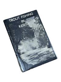
[Maps] [Africa] Central Angling Advisory Board of Kenya Colony
Trout Fishing in Kenya
Nairobi Kenya: Printed in E. Africa by W. Boyd & Co 1950. First edition. 18x13cm 64pp. Illustrated ads photos fold out map attached at rear. Staple bound in illustrated wrappers. Old tape reinforcement to spine edges rubbed owner's name to front cover. Upper corners stained else clean internally and very good. <br /> <br /> Very scarce mid-century publication a guide for English and American sportsmen seeking angling opportunities in Kenya Colony. Brown and Rainbow Trout eggs were introduced into the rivers by colonists around 1905. The sport was a popular pastime for the colonists and tourist fishing in the region continues to thrive today. The three color map at rear shows the Kenya Highlands with principle trout rivers roads and railways.<br /> <br /> OCLC cites a single holding at the University of California. Printed in E. Africa by W. Boyd & Co unknown
Referentie van de boekhandelaar : 8975
|
|
|
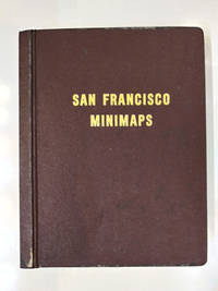
[Maps] [California]
San Francisco Minimaps
San Francisco: The Realty Index Co 1969. Hardcover. Very good. 631pp. Folio 36.5 cm Burgundy boards. With dividers and tabs. Moderate scuffing to the extremities; some discoloration to endpapers else internally clean. May require extra postage due to weight. An attractive and highly detailed volume of miniature Assessor's Blocks Maps reduced in size to make a legible yet at the same time compact and uncluttered book. With zoning information sectional maps major development areas and Assessor's Block Maps. The Realty Index Co hardcover
Referentie van de boekhandelaar : 58769
|
|
|
[Maps] [Joseph S. Wilson]
Report of the Commissioner of the General Land Office for the Year 1866
Washington D.C: Government Printing Office 1867. 1st Edition. Hardcover. Very Good. Brown pebbled cloth boards with blindstamped rules; 9" tall; 151 pp plus large folding map. Good condition with wear to spine ends of corners of boards; map itself in very good condition colors bright folded properly modern tape reinforcement at creases. -- The "Map of the United States and Territories" by Joseph S. Wilson was one of the largest and most accurate maps of the country published at the time. It clearly marks major Native American territories and the colored mineral deposits show a clear rationale for expansion to the West. Joseph Wilson was Commissioner of the General Land Office both before and after the Civil War and this map was produced during the first year of his second tenure. The accompanying report asserts the United States' right to possession of the Western territories and states encourages the population thereof and admits to continuing arbitration land claims especially in California. Government Printing Office hardcover
Referentie van de boekhandelaar : s02256
|
|
|
[MAPS] [San Francisco]
FUTURE DEVELOPMENT OF THE SAN FRANCISCO BAY AREA 1960-2020
<p>1st and only edition. 4to softcover 9 x11" Pages: xxi 94 Appendices. Approximately 130 pp. in all. Accompanied by 23 large folded maps in slipcase.</p><p>The booklet is subtitled "<strong>Economic Aspects of Comprehensive Survey of San Francisco Bay and Tributaries."</strong> It contains research data concerning land use population distribution freeway development employment and economic growth as well as a decade-by-decade chart for growth management. Most of the maps are 36"x42" some two-tone others in brilliant colors.</p><p>CONDITION: <strong>The maps are FINE</strong> folded to size with the appearance of never having been opened. <strong>The booklet is Good</strong>; a clean copy overall but with some discoloration to spine toning to rear cover and one rusted staple. The slipcase is well worn with substantial dampstaining not affecting the contents.</p> U.S. Army Corps of Engineers / U.S. Dept. of Commerce, 1957
Referentie van de boekhandelaar : k251217i

|
|
|
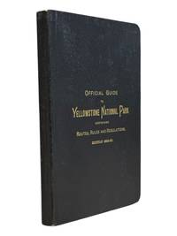
[Maps] [Wyoming] Riley, WC. W. C.
Official Guide to the Yellowstone National Park: A Manual for Tourists
St. Paul Minn: W.C. Riley 1889. 8vo 140 15pp ads and blank journal at rear. Illustrations maps large folding map in pocket at rear as issued. Original leather over card covers stamped in gilt on front with red page edges. Gift inscription on ffep in pencil dated 1907 else clean internally. A beautiful fine copy. <br /> <br /> Beautiful copy of this illustrated tourist's guide to Yellowstone giving descriptions of the attractions and features of the park with maps a brief history and rules and regulations. Riley issued a just few of these according to OCLC between 1886 and 1890. Scarce and more so in this condition - the nicest we've seen.<br /> <br /> <br /> . W.C. Riley unknown
Referentie van de boekhandelaar : 9062
|
|
|
[MAPS] BOWEN, Emanuel and John Gibson
An Accurate Map of North America. Describing and Distinguishing the British and Spanish Dominions on this great Continent; According to the Definitive Treaty Concluded at Paris 10th Feb.y 1763. Also all the West India Islands Belonging to and Possessed by the Several European Princes and States. The whole laid down according to the latest and most authentick Improvements
London: Printed for Robert Sayer 1775. Fourth Issue with title omitting the word "French" and date at lower margin changed to 2 July 1775. Large engraved four-sheet map of North America and the Caribbean with hand-colored outline figural title cartouche and two inset maps of California and Baffin & Hudson's Bay; each section measures 55cm x 122cm 21 11/16" x 48". Two vertical folds neatly reinforced on verso one on each half light wear to extremities with some faint scattered foxing several short edge tears and small splits at folds with shallow loss to upper right corner of upper half; margins untrimmed with horizontal portions unjoined; an attractive Very Good example. Stevens & Tree "Comparative Cartography" 49d in Tooley The Mapping of America p.81. Printed for Robert Sayer unknown
Referentie van de boekhandelaar : 46632
|
|
|
[Maps] David Fulton Surveyor Public Land
Hand-colored Map of Arkansas Surveying District 1840
<p>Surveyors Office Little Rock 30th Sept. 1840David Fulton Surveyor Public LandPrinted by W.J. Stone etc. Wash. for 28th Congress 2d Sess.</p><p><b>This is the scarce annotated and colored version of the map of the Arkansas Surveying District "shewing the extent of public surveys in said district on the 30th September 1840." </b> Unlike other versions of this map that have appeared this hand-colored version indicates by color the finished unfinished and relinquished townships and lines "the field notes of which have been sent to the General Land Office." The map also depicts the Arkansas and other Rivers Choctaw and Cherokee Boundary LinesLouisiana Line Little Rock and other landmarke. The size of the map is 18.5"x17.5" folded to 4"x7".</p><p><br /></p><p>Condition: Near fine. Possibly clipped from a larger volume; left margin i trimmed with several large tears t top not intruding into the image. Small light stain at boom no foxing or discoloration. </p><br /> Printed by W.J. Stone etc. Wash. for 28th Congress 2d Sess.
Referentie van de boekhandelaar : k210726b

|
|
|
[Maps] Gross, Alexander, FRGS F. R.
New War Map of Oceania and Australia - The Solomons and Other Potential Island Battle Areas in the Pacific
Geographia Map Co. New York. Paperback. Acceptable. No date c.1942. Size 41 x 27 inches Extra Large Scale. Folds to 8 x 9 inches. There are tears along many of the folds but it is still in one piece large print colors bright fair. > Language: English > Size: Folio > Media/Binding: Soft cover Geographia Map Co., New York paperback
Referentie van de boekhandelaar : CORV-BBP-09775
|
|
|
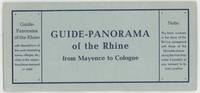
[Maps]; [Germany]
Guide-Panorama of the Rhine from Mayence to Cologne; With Descriptions of the Most Interesting Towns Villages etc. Close to the Respective Places Stamped in Relief
Mainz: W. Suder 1960. Later edition. Wraps. Near Fine. 24.5 cm x 11.5 cm folded in the wrappers. Map bound in the leporello style. Blue paper wraps printed in dark blue. A colorful map with captions printed in black in 16 folds. A map similar to this one was first published earlier in the twentieth century by a different press. The captions are in English. Castles and other landmarks from Bonn Cologne Linz Krahnenburg Koblenz and from several other suburbs and towns on the Rhine river are pictured and discussed in the map's margins. Light wear to the wraps else a sharp example. W. Suder unknown
Referentie van de boekhandelaar : 000015404
|
|
|
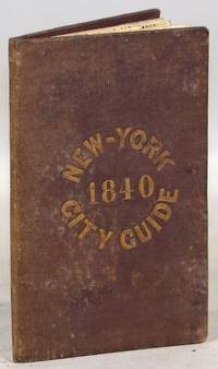
[Maps]; [New York City]; [US. History] U. S.
A Guide to the City of New-York; Containing an Alphabetical List of Streets &c. Accompanied by a new and Correct Map
New York: Tanner & Disturnell 1840. Later edition. Hardcover. Very Good. 64mo. 13 cm x 8 cm. 3 4-15 1 pp. Brown cloth with gold lettering on the front board. Yellow coated rear endpaper and rear pastedown. Illustrated with a frontispiece and with a folding map in the rear of the volume. The folding map in the rear of the volume is hand-colored. Its title is "New Map of the City of New-York with part of Brooklyn & Williamsburg". By J. Calvin Smith. Engraved on steel by Stiles Sherman & Smith. The folding map is dated 1840. Phillips 532. Guide books similar to this one were published as early as 1836. OCLC locates a few examples of this exact edition. With a list of wards streets and information on how to get around the city. A fascinating look at early nineteenth-century New York City. Light soiling to the cloth. Lacks the yellow free front endpaper and front pastedown. The folding map with one piece neatly detached but laid in the whole map is present. Tanner & Disturnell hardcover
Referentie van de boekhandelaar : 000014171
|
|
|
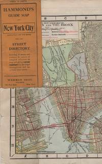
[Maps]; [New York City]
HAMMOND'S GUIDE MAP OF NEW YORK CITY: Manhattan and the Bronx
New York: Wehman Brothers Publishers 1913. Very good. An impressive color map of the island of Manhattan and the Bronx. Scale is 1" equals 1/2 mile and includes railroads subways elevated railroads surface railroads and proposed railroads. An uncommon early 20th Century New York City street map. Folding color map. Measuring approximately 18" x 36" when unfolded. In original printed card wrapper. Verso a thorough printed street index. Mild handling wear toning. A few tiny holes near fold corners. Overall well preserved; very good. Wehman Brothers Publishers unknown
Referentie van de boekhandelaar : 41637
|
|
|
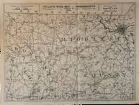
[Massachusetts – Maps – Cycling] Oliver, William T.
Nine Cyclists’ Road Maps of Massachusetts Prepared for the Massachusetts Division of the League of American Wheelmen
Lynn Massachusetts: Arthur W. Robinson 1891. Nine of a ten-map series mostly measuring 14 ½ x 19 inches. Folded with slight marginal folding and wrinkling; Near Fine. Nine of a set of ten maps of the entire state of Massachusetts produced in 1891 for the League of American Wheelmen. The League was founded in Rhode Island in 1880 as a membership organization for cyclists. Besides presiding over racing and producing cycling guidebooks it advocated for increased government spending on road improvements especially for rural roads; these maps indicate roads of superior and inferior quality. In the 1890s there was a boom in cycling’s popularity mainly because of several inventions that allowed a safer and more pleasant ride compared to that of a penny-farthing.<br /> <br /> This group is near complete; we find two complete editions on OCLC. Arthur W. Robinson unknown
Referentie van de boekhandelaar : List3031
|
|
|
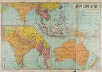
[MATSUKI, TAMANOSUKE]. 松木玉之助.
濠州・印度全圖. Gōshū Indo Zenzu. Complete Map of Australia and India.
東京.Tokyo.: 金鈴社. Kinrei-sha. 昭和十八 October 101943. Two maps printed in colour on a single side of a folded sheet. The map titled "Complete Map of India and Australia" shows the region covering Australia southern India western mainland south-east Asia Indonesia the Philippines and New Guinea. The other map titled "India and Burma" shows the region covering India Afghanistan the western section of China Burma and Thailand on the lower left side. New Zealand is in an inset map in the lower right corner. As the note on the cover says "Including the detailed descriptions of the Solomons New Guinea and southern islands" this map shows the theatres of the Pacific War and the surrounding areas. The map indicates agricultural and mineral resources as well as cities roads railways sea routes national borders etc. Cover and publication details printed on two panels on the reverse. Some marking and browning. . 金鈴社. [Kinrei-sha]. unknown
Referentie van de boekhandelaar : 159290
|
|
|
[MERVEILLEUX Charles Frédéric]:
Mémoires instructifs pour un voyageur dans les divers Etats de l'Europe: contenant des anecdotes curieuses trés propres à éclaircir l'histoire du tems; avec des remarques sur le commerce & l'histoire naturelle.
Amsterdam, H. du Sauzet, 1738. 2 tomes en un volume in-12 de [8]-228; [4]-241-[3] pages, plein veau brun, dos à nerfs orné de filets et fleurons dorés, pièce de titre beige, roulette dorée sur les coupes, tranches rouges. Coins à peine frottés, tache d'encre p. 63 du tome 2.
Referentie van de boekhandelaar : 8764

|
|
|
[Medina - Al-Ula].
Medina. World (Asia) 1:1,000,000. Series 1301. Edition 4-GSGS. Sheet NG-37 & part NG-36. [London], War Office and Air Ministry, 1960.
Colour printed map, ca. 810 x 608 mm. Scale: 1:1,000,000. Shows boundaries, highways and roads, railways, rivers and water features, and other details. Rare 4th GSGS edition of this map of Saudi Arabia, as part of the International Map of the World series, showing the western coastline as well as the cities Medina and Ha'il and the oasis of Al-Ula in the interior. - Stamp of ownership of Arizona State University, along with "withdrawn" and "superseded" stamps on top and next to it. - 56 mm piece of adhesive tape on top edge; pencil marks to lower right corner. OCLC 634944590. Cf. OCLC 35899626 (1962 ed.).
|
|
|
[MEKONG DELTA - VIETNAM WAR MAPS]
Khanh Hu'ng and Quan Long Vietnam. Series 1501 AIR. Sheets NC 48-10 & 11. Edition 2.
Washington D.C.: Army Map Service. 1967. Two printed colour adjoining maps 73 x 55.6 cms and 55.6 x 73 cms original folds inked operational annotations to the Quan Long sheet multiple marginal legends noting aerodromes and radio facilities roads railroads and boundaries glossary of terms much of the text is in both English and Vietnamese in very good condition. Detailed U. S. Army maps of the Mekong Delta and Southern Vietnam extending from Rach Gia in the north to the area just south of Quan Long Ca Mau in the south and east including BacLieu and CanTho. The island of Con son is at lower right of the Khanh Hu'ng sheet. Operational notes are inked around Quan Long are marked and the U Minh Forest the impenetrable "forest of darkness" is noted in ink. <br> <br>. . Army Map Service. unknown
Referentie van de boekhandelaar : 203840
|
|
|
[MEXICAN WAR] [MAPS]
17 maps extracted from James K. Polk’s Message from the President
Washington 1848. Caption titles of the maps listed below in chronological order according to the date of the action described in the map; almost all bear the lithographer’s slug. Several have tears in marginal folds and a few show some foxing one uniformly browned. All are serviceable examples almost all very good. 1 Sketch of the Actions Fought at San Pascal in Upper California between the Americans and Mexicans Dec. 6th & 7th 1846 caption title. 11 x 7 ¾ inches neatline. 2 Sketch of the Passage of the Rio San Gabriel Upper California by the Americas Discomfiting the Opposing Mex. Forces Jan 8th 1847 caption title. From a sketch by Lt. Emory. P. S. Duval Lith. Phil. 6 3/8 x 8 ¼ inches neatline. 3 Sketch of the Battle of Los Angeles Upper California Fought between the Americans and Mexicans Jany 9th 1847 caption title. From a sketch of Emory. 5 ¾ x 8 ¼ inches neatline. 4 Sketch Accompanying Col. Price’s Despatch of 15th Feb. 1847 caption title. 8 1/8 x 5 ¾ inches neatline. 5 Linnard Capt. T. B. Plan of the Battle of Buena-Vista Fought February 22nd and 23rd 1847 caption title. Surveyed by Capt. Linnard & Lts. Pope & Franklin. Lith of P. S. Duval Phil. Notes in several margins. 16 ¼ x 20 inches neatline. 6 Sketch of the Battle of Sacramento Feb. 28th 1847 caption title. Printed note of the battle in lower margin. 12 ½ x 9 ½ inches neatline. 7 Coppee Lt. H. Survey of the Mexican Lines of Defence at Cerro Gordo and the Lines of Attack of the American Army under Major General Scott. On the 17th and 18th of April 1847 caption title. Surveyed by Major Turnbull and Capt. McClellan Top. Engineers. Lith of P. S. Duval Phil. 12 ¼ x 18 ¾ inches neatline. 8 Sketch Accompanying Col. Price’s Despatch of 18 April 1847 caption title. P. S. Duval Lith Phil. 9 ½ x 11 ½ inches neatline. 9 Map of the California coast supplied title. June 19th 1847. Table in lower margin recording distances between towns and number of men available in each. Lith of P. S. Duval Phil. 14 ½ x 11 ¾ inches neatline. 10 Hardcastle Lt. Edmund. Battles of Mexico Line of Operations of the U. S. Army under the Command of Major General Winfield Scott on the 19th and 20th of August 1847 caption title. Surveyed by Major Turnbull Capt. McClellan and Lt. Hardcastle. Lith of P. S. Duval Phil. 23 ½ x 28 ½ inches neatline. 11 Hardcastle Lt. Edmund. Map of Genl. Worth’s Operations on the 20th of Augt. 1847 caption title. Surveyed by Capt. Mason of Engineers and Lt. Hardcastle of Top. Engrs. 18 ½ x 30 ¾ inches neatline. 12 Hardcastle Lt. Edmund. Battle of Molino Del Re: Sketch of the Operations of the 1st Division United States Army under the Command of General Worth on the 8th Sept 1847 caption title. P.S. Duval Lith Phil. 19 3/8 x 12 ¼ inches neatline. 13 Hardcastle Lt. Edmund. Battles of Mexico Line of Operations of the U. S. Army under the Command of Major General Winfield Scott on the 8th 12th and 13th of September 1847 caption title. Surveyed by Major Turnbull Capt. McClellan and Lt. Hardcastle. Lith of P. S. Duval Phil. 28 x 21 ½ inches neatline . 14 Pemberton Bvt. Capt. J. C. Sketch of the Route of General Worth’s Column from Chapultepec to the Alameda in the Attack upon the City of Mexico 13th & 14th September 1847 caption title. 14 ¼ x 10 ¼ inches neatline. Notes in lower margin. 15 Hardcastle Lt. Edmund. Map of the Valley of Mexico caption title. Lith of P. S. Duval. 12 x 16 ¾ inches neatline. Fold separations from edges. 16 Plan Accompanying Gen. Quitman’s Report caption title. Duval’s Lith Press. 13 x 17 ¾ inches neatline. Notes on the battle in lower margin. Some hand coloring. Two splits through margin at folds uniformly browned. 17 Sketch Accompanying Col. Price Despatch caption title. 9 ½ x 11 ½ inches neatline For the lot of 17 maps unknown
Referentie van de boekhandelaar : 70172
|
|
|
[Michelin]
CARTE MICHELIN N° 328 : AIN, HAUTE-SAVOIE
Une carte géographique "Local" au 1:150.000e, éditée en 2004, bon état
Referentie van de boekhandelaar : LFA-126744324
|
|
|
[Michelin]
CARTE MICHELIN : RHÔNE-ALPES
Une carte au 1:200.000e, éditée en 2012, Michelin, bon état
Referentie van de boekhandelaar : LFA-126750293
|
|
|
[Michelin]
CARTE MICHELIN : SUISSE
Une carte au 1:400.000e, éditée en 1978, Michelin, bon état
Referentie van de boekhandelaar : LFA-126750294
|
|
|
[Miroir de l'Histoire]
MIROIR de l'HISTOIRE n° 169 Janvier 1964
Une revue de 110 pages, format 170 x 230 mm, illustrée, brochée
Referentie van de boekhandelaar : LFA019c5
|
|
|
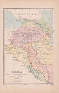
[MIDDLE EAST - MAP.] WELLER, EDWARD.
Armenia Mesopotamia Babylonia and Assyria.
London & Glasgow.: William Collins Sons & Co. circa1870s. Map of ancient Armenia and Mesopotamia printed in colour with the Retreat of the Ten Thousand during the final years of the Peloponnesian War picked out in original hand colour 14.9 x 21.9 cm paper toned at the edges small silverfish abrasions affecting the bottom grid and margin but in very good condition. Text in Latin. . William Collins, Sons & Co. unknown
Referentie van de boekhandelaar : 174962
|
|
|
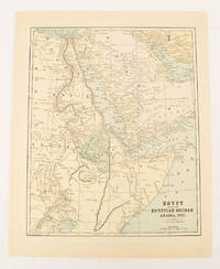
[MIDDLE EAST - MAP]. FISK & CO., (ENGRAVERS).
Egypt showing the Egyptian Soudan Arabia etc.
New York.: Hunt & Eaton. Circa1893. Printed map in colour elevation shown with hachures 29 x 23.5 cm text on the verso relating to entries for Afghanistan Beluchistan and Turkey prepared for Hunt & Eaton's "New York Recorder's Atlas" small tears to the top edge but in very good condition. . Hunt & Eaton. unknown
Referentie van de boekhandelaar : 174920
|
|
|
[Middle East] - Gaebler, Eduard.
Vorder-Asien. Leipzig, [1892].
254 x 201 mm. Lithographed map. Scale 1:25,000,000. Gilt wooden frame (290 x 357 mm). Political map of the Middle East prior to WWI, detailing the Arabian Peninsula, the Gulf, Iran, and the Ottoman Empire, as well as parts of Africa, Russia and China. Among the labelled cities on the Gulf are Sharjah, Al-Wakrah and Manamah. With 4 inset maps showing Palestine (1:2,500,000) and Jerusalem with its surroundings (1:500,000) as well as the southern German states and Lake Constance for scale. - Early edition of Eduard Gaebler's map of western Asia, published published in "Neuester Hand-Atlas über alle Teile der Erde" (Leipzig, Gaebler's Geographisches Institut, 1892). The map saw numerous reissues; a revised edition appeared in Gaebler's "Kleiner Handatlas" as late as 1933. - Slight foxing. Frame shows some traces of worming; tiny piece of wood chipped near left margin. An appealing map in an attractive wooden frame with a gilt border.
|
|
|
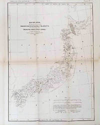
[MINERAL RESOURCES OF JAPAN] MUNROE, HENRY S.
The Mineral Wealth of Japan.
Philadelphia.: American Institute of Mining Engineers. Sherman & Co. printers. 1878. Large folding map of Japan showing "some of the more important Mining Districts Coal Fields etc." small fold split without loss tables 67pp. Covers a little scuffed and discoloured overall in very good condition. Scarce offprint separately paginated of a paper included in Volume V of the Transactions of the American Institute of Mining Engineers. The author Henry S. Munroe had been retained by the Japanese Government as Assistant Geologist and Mining Engineer with the Geological Survey of Yesso for the Hokkaidō Colonization Agency. His work laid the foundations for the future coal mining industry in Hokkaido. The report contains two lengthy tables relating to coal production and quality. . American Institute of Mining Engineers. Sherman & Co., printers. unknown
Referentie van de boekhandelaar : 210211
|
|
|
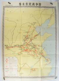
[MUSEUM OF CHINESE HISTORY] 中国历史博物馆.
秦末农民战争图. Qin mo nong min zhan zheng tu. Chinese Educational Map - Map of Peasant Rebellion during Late Qin Period.
Beijing.: 地图出版社. Di tu chu ban she. 1st Edition 2nd Printing. 1981. Large Chinese coloured educational map folded scale 1:2000000. Legend lower left corner shows the routes of military advance led by peasant rebellion leaders' 陈胜Chen Sheng and 吴广Wu Guang in red and other military activities led by 项羽Xiang Yu and 刘邦Liu Bang in various colours. In original worn paper wrapper map in very good condition. Text in Chinese. Map measures 105.5 x 76.6cm. . 地图出版社. [Di tu chu ban she]. unknown
Referentie van de boekhandelaar : 173280
|
|
|
[N. A.].
[OTTOMAN MILITARY MAP of PATAGONIA and FALKLAND ISLANDS: ROUTE of DRESDEN] Alman kruvazörü Dresden'in takîbi ve tahrîbi.
Very Good Turkish, Ottoman (1500-1928) Original color map. Elephant folio. (59x75 cm). In Ottoman script. [OTTOMAN MILITARY MAP of PATAGONIA and FALKLAND ISLANDS: ROUTE of DRESDEN] Alman kruvazörü Dresden'in takîbi ve tahrîbi. SMS Dresden cruiser's routes between 1913-1915 (World War 1) on the Patagonian shelf; western shores of South America, Patagonia and Falkland Islands. Dresden spent much of her career overseas. After commissioning, she visited the United States in 1909 during the Hudson-Fulton Celebration, before returning to Germany to serve in the reconnaissance force of the High Seas Fleet for three years. In 1913, she was assigned to the Mediterranean Division. She was then sent to the Caribbean to protect German nationals during the Mexican Revolution. In mid-1914, she carried the former dictator Victoriano Huerta to Jamaica, where the British had granted him asylum. She was due to return to Germany in July 1914, but was prevented by the outbreak of World War I from doing so. At the onset of hostilities, Dresden operated as a commerce raider in South American waters in the Atlantic, then moved to the Pacific Ocean in September and joined Maximilian von Spee's East Asia Squadron. Dresden saw action in the Battle of Coronel in November, where she engaged the British cruiser HMS Glasgow, and at the Battle of the Falkland Islands in December, where she was the only German warship to escape destruction. She eluded her British pursuers for several more months, until she put into Robinson Crusoe Island in March 1915. Her engines were worn out and she had almost no coal left for her boilers, so the ship's captain contacted the local Chilean authorities to have Dresden interned. She was trapped by British cruisers, including her old opponent Glasgow. The British violated Chilean neutrality and opened fire on the ship in the Battle of Más a Tierra. The Germans scuttled Dresden and the majority of the crew escaped to be interned in Chile for the duration of the war. The wreck remains in the harbor; several artifacts, including her bell and compass, have been returned to Germany.
|
|
|
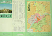
[NANJING MUNICIPAL INSTITUTE OF SURVEYING AND DESIGN]. 南京市勘测设计院.
南京市交通图. Nanjing shi jiao tong tu. Naning City Transportation Map.
No place of publication.: 江苏人民出版社.Jiangsu ren min chu ban she. 1st Edition 2nd Printing. 1977. Colour Chinese transportation map featuring the city of Nanjing capital city of Jiangsu Province and its surrounding regions. Upper side: A transpiration map of Nanjing and neighbouring counties right section with a list of names of stations buses trains coaches ferries and their addresses lower right edge tourist guide including the addresses and phone numbers of major travel agents hospitals cinemas and more left section accompanied by two tables of bus routes. On reverse: a "Map of Nanjing Municipal Transpiration Map" scale not given a chart of terminus for bus and trolley bus lower right section. Some soiling on reverse stamp of a prior dealer in Guangzhou a handwritten date of "September 17th 1977" upper side light creases good copy. Text in Chinese. Sheet measures 37.8 x 52.3cm. . 江苏人民出版社.[Jiangsu ren min chu ban she]. unknown
Referentie van de boekhandelaar : 137003
|
|
|
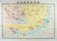
[NATIONAL MUSEUM OF CHINESE HISTORY]. 中国历史博物馆.
中法战争形势图. Zhong Fa zhan zheng xing shi tu. Situation Map of the Sino-French War.
北京. Beijing.: 地图出版社.Di tu chu ban she. 1978. Large Chinese map in colour showing southern part of China and northern Vietnam folded in original envelope scale 1: 150000 inset map upper left corner scale 1:800000. Both maps show the battles between Qing court and French army between 23 Aug 1884 and 25 Mar 1885. Original paper envelope repaired with acidic free tape map in very good condition. Text in Chinese. Sheet measures 76.8 x 107.1cm. . 地图出版社.[Di tu chu ban she]. unknown
Referentie van de boekhandelaar : 171343
|
|
|
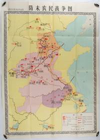
[NATIONAL MUSEUM OF CHINESE HISTORY]. 中国历史博物馆.
隋末农民战争图. Sui mo nong min zhan zheng tu. Chinese Education Map - Map of the Peasant War in Late Sui Dynasty.
北京. Beijing.: 地图出版社.Di tu chu ban she. 1st Edition 1st Printing. 1980. Large Chinese education map folded with original envelope scale 1:1500000 legend left lower corner showing the military advance routes and battle grounds led by several leaders of the agrarian rebels including 王薄 Wang Bo 窦建德 Dou Jiande 杜伏威 Du Fuwei and 翟让 Zhai Rang. Very good copy. <br> <br>Text in Chinese. Sheet measures 106.8 x 76.52cm. . 地图出版社.[Di tu chu ban she]. unknown
Referentie van de boekhandelaar : 176714
|
|
|
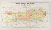
[NEW SOUTH WALES - 1912 COLOUR MAP].
Drildool Bore Water Trust District Plan shewing proposed Boundaries.
Sydney.: W.A. Gullick Govt. Printer. 1912. Large lithographed folding county map 78.8 x 45.4 cm the parishes highlighted in colour two small fold splits slight toning in very good bright condition. Attractive map from the Report on the first Interstate Conference on Artesian Water Sydney 1912 showing boundaries of water trust districts proposed boundaries with position and length of drains for the counties of Denham and Jamison in northern New South Wales boundaried by the Namoi River to the South. . [W.A. Gullick, Govt. Printer] unknown
Referentie van de boekhandelaar : 177249
|
|
|
[Oldmixon, John] | maps by Herman Moll
British Empire in America Containing the History of the Discovery Settlement Progress and Present State of All the British Colonies On the Continent and Islands of America . . . With Curious Maps of the Several Places Done from the Newest Surveys. By Herman Moll Geographer 2 Volumes Complete
London: John Nicholson 1708. Full Leather. Very Good binding. Octavo. xxxviii 2 412; 2 382 2 ads 32 index pp. maps. First edition. Contemporary paneled-calf boards with modern reback. Title page to Volume 1 and four of the eight maps are lacking but are supplied in tasteful facsimile. The maps in facsimile are the North America New England Virginia and Maryland and Carolina. Bindings are solid and presently nicely; contents are clean and bright; but for the maps and title page this is an exceptional set. <br /> <br /> Of this work William Reese writes: "This basic 18th-century reference work on British America . . . offers an excellent comprehensive survey of Great Britain's American colonies at the point when those on the mainland of North America had grown past their initial phase and were expanding rapidly in population and productivity. . . . This important contemporary work would probably have been the first point of reference for any Englishman at the time" Reese Struggle for North America 1. Usually attributed to Oldmixon who penned the dedication but occasionally gets attributed to Moll according to Sabin. A significant work by the British historian. Howes O-61 "aa"; European Americana 1708/95; ESTC T45485; Sabin 57156. John Nicholson unknown
Referentie van de boekhandelaar : 8917
|
|
|
[OREGON -- MAPS]. GILHAM, [Fred Howes].
Gilham’s guide Oregon 1930. A simple accurate up-to-date index of Oregon for business firms. Every Oregon home should have one.
Portland OR: Gilham’s Guide 1930. 8vo. 91 1 pp. Maps throughout. Tan printed softcovers minor darkening and thumbing to fore-edges 1 small corner creased still a VG copy. First edition of this scarce automobile travel map guide to Oregon for travelers and businessmen. Supplied with an extended index the strip maps all offer auto roads and stage roads for buses as well as showing railroad lines. In addition ferries post offices Western Union Express Offices and much more are shown. In addition there are mileage maps for Washington & Oregon included as well. Gilham 1882-1949 was a lifetime Portland OR resident who published gravel guides and histories on the Pacific Northwest but after losing his business during the Great Depression went to work for the Jones Lumber Co. Gilham’s Guide, paperback
Referentie van de boekhandelaar : 56484
|
|
|
[PARIS]
Album de cartes et vues de Paris
Paris, début du XXe siècle. In-8, 46 pl., chagrin brun d'Antoine Maître, décor à froid sur les plats et le dos, tranches dorées (épidermures, fermoirs manquants).
Referentie van de boekhandelaar : 19206

|
|
|
[Patrimoine en Isère]
CARTE MATHEYSINE
Une carte géographique au 1:100.000e, éditée en 2008, bon état
Referentie van de boekhandelaar : LFA-126728944
|
|
|
[Paul VI]:
Visite du Pape Paul VI à la conférence internationale du Travail, Genève 10 juin 1969.
Enveloppe avec décor gaufré, timbre spécial édité à l'occasion de la visite papale, oblitéré à la date de la conférence. En parfaite condition.
Referentie van de boekhandelaar : 4579

|
|
|
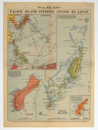
[PACIFIC - WORLD WAR II MAP].
Pacific Island Stepping Stones to Japan.
Chicago.: Chicago Daily Tribune. 28 September1944. Colour pictorial map on a single newspaper leaf archivally laid down on linen 50 x 39.2 cms; 59.3 x 43.3 cms sheet including captions faint toning to fold lines very good condition. Vivid colour maps of the Palau Islands Guam and Saipan in the Marianas and an inset location map published in the "Chicago Daily Tribune" in September 1944 months after the landing of US and Allied Forces in the offensive against the Japanese during the Pacific War. . Chicago Daily Tribune. unknown
Referentie van de boekhandelaar : 208880
|
|
|
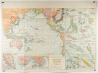
[PACIFIC - SOUTHEAST & EAST ASIA- MAP - 1930S WITH INSETS OF HONG KONG AND SINGAPORE]
Pacific Ocean. Robinsons New Map of the Pacific Ocean with Insets Showing Island Groups in Detail. Map title: Map of Pacific Ocean. Mercators Projection.
Sydney: H.E.C. Robinson. Circa1930s. Printed colour maps in all 65.5 x 99cm the main map roughly 50 x 65 cms on a single sheet 76 x 101.3 cms; a little carelessly folded decorative blue title cover a little dusty and a few fold splits and edgewear but in good condition. The exceptional feature of this map are the twenty six large scale inset maps of Pacific islands including: Malay States Singapore Hong Kong these at lower left Japan Philippine Islands Hawaiian Islands Fiji Solomon Islands Western and Eastern Samoa Tahiti Saipan New Caledonia and Dependencies and many others. <br> <br>The main map of the Pacific Ocean stretches from Southeast Asia including all of Australia and New Zealand the west coast of the Americas the Kamchatka Peninsula Manchukuo Manchuria and most of China. Korea and Taiwan are marked as Japanese Territory. Possessions of Britain France the Netherlands and the United States are highlighted. <br> <br>An incredibly rich source of information on the Pacific theatre during the years leading up to World War II. From the Sydney publisher H.E.C. Robinson the firm founded in 1895 by Herbert Robinson 1857-1933 a founder of the Royal Geographical Society of Australasia. . H.E.C. Robinson. unknown
Referentie van de boekhandelaar : 205997
|
|
|
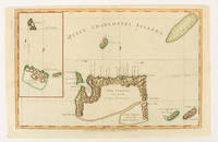
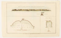
[PACIFIC - MAP] WALKER, JOHN (ENGRAVER).
Queen Charlotte's Islands.
London.: Alexander Hogg at the King's Arms. circa1784. Engraved map on laid paper 21.4 x 33.7 cm inset of Gower's Simson's and Carteret's Island early outline hand colour trimmed to the plate mark at the top edge three small edge tears affecting the upper margin only slight paper toning but a most attractive map in very good condition. Fine impression of the Queen Charlotte's Islands Solomon Islands. It features the Swallow's track the ship's route taken by Captain Philip Carteret in 1767 the British naval officer and explorer who participated in two of the Royal Navy's circumnavigation expeditions in 1764–66 and 1766–69. . Alexander Hogg at the King's Arms. unknown
Referentie van de boekhandelaar : 174895
|
|
|
[PACIFIC - MAP] WALKER, JOHN (ENGRAVER).
The North side of Queen Charlotte's Islands as it appeared running along shore to the Westward.
London.: Alexander Hogg at the King's Arms. circa1784. Engraved map in triptych on laid paper 20.1 x 32.7 cm three insets: cross section of the north side of Queen Charlotte's Islands Solomon Islands with detail of a volcano "6 leagues North"; Swallow's Bay Harbour; and Byron's Harbour early hand colour trimmed to the plate mark at the top edge neat sealed tear affecting the publisher's caption slight edge wear and paper toning but a most attractive map in very good condition. Attractive engraving of the Queen Charlotte's Islands Solomon Islands. The Islands were named for the consort of King George III by Philip Carteret the British naval officer and explorer who participated in two of the Royal Navy's circumnavigation expeditions in 1764–66 and 1766–69. His ship the Swallow gave her name to the Bay and Carteret's commanding officer on the first of his voyages John Byron to the Harbour depicted in this most attractive early chart. . Alexander Hogg at the King's Arms. unknown
Referentie van de boekhandelaar : 174896
|
|
|
[Pacific Northwest Maps] Hayes, Derek.
Historical Atlas of the Pacific Northwest: Maps of Exploration and Discovery British Columbia Washington Oregon Alaska Yukon.
<p>Seattle::: Sasquatch Books 1999. Third Printing of the First Edition. A Fine copy in a Fine bright unclipped dust jacket. This volume provides a visual journey through four centuries of exploration and discovery beginning with the 16th Century Spanish and English explorers. Included are accounts and the cartographic contributions of Sir Francis Drake Vitus Bering James Cook Alexander Mackenzie George Vancouver Lewis & Clark and dozens of other important travelers. Includes 325 map reproductions.</p> Sasquatch Books,, hardcover
Referentie van de boekhandelaar : 29225 ISBN : 1570612153 9781570612152
|
|
|
[Pacific Northwest Maps] Hayes, Derek.
Historical Atlas of Washington and Oregon with Original Maps.
<p>Berkeley:: University of California Press 2011. First Printing of the First US Edition. A Fine copy in a Fine bright unclipped dust jacket. This gorgeous atlas illustrated throughout with more than 500 colorful images and maps provides a visually rich and textually engaging history of the states of Oregon and Washington. Derek Hayes brings his enthusiasm and expertise to a full range of topics beginning with the first inhabitants and tracing the westward expansion conflict between settlers and Native Americans and the establishment of the Oregon Trail. We see in vivid images old maps and lively text the coming of the railroads and the rapid establishment of the coastal ports northwest cities and roads the fur and lumber industries and the large farms.</p> University of California Press, hardcover
Referentie van de boekhandelaar : 28184 ISBN : 1570612153 9781570612152
|
|
|
[Palestine].
Situs Terrae Promissionis SS Bibliorum Intelligentiam Exacte Aperiens: Per Christianum Adrichomium Delphum". Cologne, Kramer, 1682.
Engraved map, printed from two plates and assembled. Ca. 1065 x 390 mm (printed area ca. 1005 x 350 mm). Large and decorative map of the Holy Land, printed from two plate, from Christian van Adrichem's "Theatrum terrae sanctae et biblicarum historiarum". Van Adrichem's map is oriented toward the east and shows the twelve tribes of Israel on both sides of the River Jordan. The coastline runs from Sidon in Lebanon to Alexandria in Egypt, also showing part of the Red Sea. In the Mediterranean, off the coast, several ships and sea monsters are visible. On the Dead Sea are four burning cities: Sodom, Gomorrah, Zeboim, and Adama. - Folds smoothed and reinforced in places. A good, strong impression.
|
|
|
[Pennsylvania] [Pictorial Maps] King, Samuel A.
Cornplanter's Kingdom: The Allegheny National Forest and Environs
DuBois PA: Samuel A. King 1952. Revised 1952. Folding map 25x19" printed in red and black. Sportsman's club label to upper margin with some offsetting to lower. Small split at fold intersections title and a few stains to blank verso otherwise a clean near fine example. <br /> <br /> Very popular map which was originally designed and published by Samuel A. King in 1951 and revised in 1952 and 54. According to OCLC there were also 1960s and 70s printings under slightly different titles. This map shows the Allegheny National Forest and surrounding counties with animal silhouettes tracks and a portrait of John O'Bail the Cornplanter last of the great Seneca chiefs. Made for motorists hunters and anglers it shows paved and clay roads trails pipe and power lines fire and lookout towers state parks game lands airports and towns with post offices.  <br /> <br /> The early copies of this map are somewhat scarce and there are many modern reprints available. OCLC cites 8 holdings for the '51-54 editions with just 1 being the '52. A lovely example.  . Samuel A. King unknown
Referentie van de boekhandelaar : 9160

|
|
|
[PHOTOGRAPHIE].-
L'Artiste Photographe.-
ND Photo. Série des Scènes Parisiennes. (Vers 1905). Carte postale (14x9cm) ayant voyagé, oblitération de 1906. Tout petit défaut à un coin sinon bon état. Rare.
Referentie van de boekhandelaar : ORD-8404
|
|
 De zoekresultaten per email ontvangen
 Zoekresultaten downloaden als PDF
 RSS feed


