|
Sinclair, A.J.; Wynne-Edwards, H.R.; Brown, A. Sutherland
An Analysis of Distribution of Mineral Occurrences in British Columbia: Bulletin No. 68
125 pages including bibliography and appendices. "Distribution of mineral occurrences in British Columbia recorded in an extensive computerized file." - from page 5. Contents include mineral commodity occurrence maps, quantitative approach to regional analysis of data, and discussion (mineral resource potential, metallogeny). Usual library markings. Moderate wear. Sound binding. A solid working copy. Book

|
|
|
Singleton, David
The North West : Land for Leisure
Ex-library book with usual marks and stamps. A clean tight copy with no bumping to corners. Dust jacket not price clipped or torn or creased with slightly faded spine. 96pp. How our growing leisure time is changing the landscape of the region. Focus on England's North West

|
|
|
SITUATIONNISTES].
Misère de la révolution et révolution de la misère.
Strasbourg Sans nom, 12 décembre 1968 1968 1 vol. broché 1 feuillet dactylographié recto-verso. Tract strasbourgeois signé "Les Enragés" dénonçant la tiédeur de la dernière assemblée générale à la Faculté des Lettres.
Bookseller reference : 90689
|
|
|
SITUATIONNISTES].
On se fout de nous et ce n'est qu'un début...
Strasbourg sans nom 1968 1 vol. broché 1 feuillet dactylographié recto-verso, daté du 3 décembre 1968, non signé. Tract strasbourgeois en réaction à la loi Faure du 12 novembre.
Bookseller reference : 90688
|
|
|
SITUATIONNISTES].
On se fout de nous et ce n'est qu'un début...
Strasbourg sans nom 1968 1 vol. broché 1 feuillet dactylographié recto-verso, daté du 3 décembre 1968, non signé. Tract strasbourgeois en réaction à la loi Faure du 12 novembre.
Bookseller reference : 90688
|
|
|
SJOBERG, Axel.
Fotografier ofver Trollhattan.
Hardcover oblong de 18x11cm, 10 cartes sur carton depliant, cartonnage decor original + fermoir dore.-- 10 Blat, illustriertes mit goldgepragtem Deckel dieser Band enthält einen Leporello mit 10 Fotografien von Trollhättan auf Karton. Excellent état (cartonnage impeccable, dorures tres fraiches) - Very Good ++++. [BU-11]
|
|
|
SJÆLLAND & MØN - WESSEL, CASPAR & H. SKANKE.
Kort over Siælland og Møen med tilgrænsende Kyster af Skaane, Falster, Laaland, Langeland, Thorsinge, Fyen, Samsöe og Jylland under det Kongl. Videnskabernes Selskabs Direction ved rigtig Landmaaling optaget og ved trigonometriske samt astronomiske Op...
(København), 1777. 62x68 cm. Kobberstukket kort opdelt i 24 sektioner og opsat på lærred, foldet i en samtidig kassette.
Bookseller reference : 31610
|
|
|
SJÆLLAND & MØN - WESSEL, CASPAR & H. SKANKE.
Kort over Siælland og Møen med tilgrænsende Kyster af Skaane, Falster, Laaland, Langeland, Thorsinge, Fyen, Samsöe og Jylland under det Kongl. Videnskabernes Selskabs Direction ved rigtig Landmaaling optaget og ved trigonometriske samt astronomiske Op...
(København), 1777. 62x68 cm. Kobberstukket kort opdelt i 24 sektioner og opsat på lærred, foldet i en samtidig kassette.
|
|
|
SJÆLLAND - (PONTOPPIDAN, ERIC).
Generalem et prorsus Novam Siælandiæ....officiosissime inscribit E.P. (Eric Pontoppidan).
(Kiøbenhavn, Godiche, 1767). 46,5 x 55,5 cm. Kobberstukket kort over Sjælland med stor fin rokokkokartouche. Lidt tæt beskåret, et par små revner ved venstre margin repareret.
Bookseller reference : 43464
|
|
|
SJÆLLAND - (PONTOPPIDAN, ERIC).
Generalem et prorsus Novam Siælandiæ....officiosissime inscribit E.P. (Eric Pontoppidan).
(Kiøbenhavn, Godiche, 1767). 46,5 x 55,5 cm. Kobberstukket kort over Sjælland med stor fin rokokkokartouche. Lidt tæt beskåret, et par små revner ved venstre margin repareret.
|
|
|
SKELTON R.A.
Decorative Printed Maps of the 15th to 18th Centuries.
London. Spring Book. 1965. Grand In-8. Cart. avec jaq. 80 p. + 84 planches H.T. BE.
Bookseller reference : 34089
|
|
|
Skelton, R. A.
Decorative Printed Map of the 15th to 18th Centuries
Ex-library book with usual (minimal) marks and stamps. Light foxing to last few pages. No other marks or inscriptions. No creasing to covers or to spine. A very clean very tight copy in a library binding with very slightly marked boards, bumping to lower edge and minor rubbing to corners. All maps in excellent condition. 84 plates of maps plus text on 80pp. This book serves as a resource of specimens of maps and as an elementary guide to the study of maps printed from wood blocks or copper plates between the 15th and the 18th centuries.

|
|
|
Skelton, R.A
Decorative Printed Maps of the 15th to 18th Centuries
London Spring Books 1967. 4° 80 S + 83 taf. m. Kart. OPp. m. O.Umsch. Umsch. minim. berieb. sonst Buch sehr gut. Zust. Sprache: englisch
Bookseller reference : 1426BB
|
|
|
Skelton, R.A.
Decorative Printed Maps of the 15th to 18th Centuries
80 pages plus 84 plates. "A revised edition of 'Old Decorative Maps and Charts' by A.L. Humphreys with 84 reproductions and a new text by R. A. Skelton" - from title page. "Provides a survey of maps printed from copper plates or wood-blocks between the 15th and 18th centuries." - from dust jacket. Contents clean and unmarked. Binding sound. Moderate wear to blue cloth-covered boards. Closed tears to dust jacket now in mylar. Nice working copy of this wondrous reference. Book

|
|
|
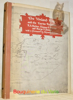
SKELTON, Raleig A. - MARSTON, Thomas H. - PAINTER, George D.
The Vinland Map and the Tartar Relation. For the Yale University Library with a Foreword by Alexander O.Vietor.
London, New Haven and London Yale University Press 1963, 295x240mm, 289pages, editor's binding with jacket. Book in good condition.
Bookseller reference : 12085
|
|
|
SKELTON, Raleigh A., MARSTON, Thomas E. y PAINTER, George D.
The Vinland Map and the Tartar Relation. With a foreword by Alexander O. Vietor.
New Haven-London, Yale University Press, 1965. Folio; XII-291 pp., con 24 reproducciones de mapas entre el texto y en láminas aparte, algunas de ellas plegadas. Encuadernación original en media tela. Un estudio fundamental sobre los orígenes de la debatida cartografía referente a Vinlandia y las expediciones a las costas americanas en el medievo.

|
|
|
Sketch Maps Bythe Author,Bagley, William A.
Kent-Northern Area Walks For Motorists4 Warne walking guides
Warne 1985-01-31. Paperback. Very Good. in x in x in. Warne paperback
Bookseller reference : mon0000842230 ISBN : 072322806x 9780723228066

|
|
|
Sketch Maps by F. Rodney Fraser
Lothian And the South East Borders Walks For Motorists28 Warne walking guides
Paperback. Very Good. paperback
Bookseller reference : GOR003613571 ISBN : 0723221596 9780723221593

|
|
|
Sketch Maps by JLatham J. La
Walking the Pennine Way Warne walking guides
Paperback. Very Good. paperback
Bookseller reference : GOR001278518 ISBN : 0723228035 9780723228035

|
|
|
Sketch Maps by the Author
Wye Valley Walks For Motorists27 Warne walking guides
Paperback. Very Good. paperback
Bookseller reference : GOR003922191 ISBN : 0723221472 9780723221470

|
|
|
Skinner, Annabel
Tanzania & Zanzibar
No marks or inscriptions. No creasing to covers or to spine. A very clean very tight copy with bright unmarked boards and no bumping to corners. 437pp. Travel guide to east African countries.

|
|
|
SKINNER, John.
Voyages au Pérou, faits dans les années 1791 à 1794, par les pp. Manuel Sobreviela, et Narcisso y Barcelo; précédés d'un tableau de l'état actuel de ce pays, sous les rapports de la géographie, de la topographie, de la minéralogie, du commerce, de la littérature et des arts, des mœurs et coutumes de ses habitans de toutes les classes
Paris, J.G. Dentu, 1809. 3 volumes TEXTE, 2 vol. in-8°,[2]-xii-385, [2]-427 pp. , brochage d’attente orange, étiquette avec titre au dos, quelques frottement. ATLAS, 1 vol. in-4° (290x225),12 planches sous serpente en couleurs et une carte de Lapie, reliure d’attente, titre sur le plat, dos manquant, coutures apparentes, la carte est volante et datée de 1829, elle provient d’un autre ouvrage
Bookseller reference : PHO-1737
|
|
|
SLA. Marshall Maps by Mark Lennox S. L.
Crimsoned Prairie : The Indian Wars on the Great Plains
Scribners January 1970. Hardcover . 7.5 Bulk HB Standard. Scribners hardcover
Bookseller reference : 436457
|
|
|
Slesser, Malcolm & Photographs and Maps
Red Peak
Coward-McCann Inc 1964-01-01. First Edition. Hardcover. Good/Good. 0x0x0. The binding is clean and tight with minor shelf wear. Light wear & soiling on edges of text block. Small chip at bottom edge of rear endpapers. Light tanning on pastedowns & endpapers. Pages toning with age otherwise Text and images unmarked. Price clipped dj worn & toned in a mylar cover. Coward-McCann, Inc hardcover
Bookseller reference : CHAPsleRED
|
|
|
Slesser, Malcolm & Photographs and Maps
Red Peak
Coward-McCann Inc. Near Fine in Very Good dust jacket. 1964. Hardcover. A book that is used but still very attractive with dustjacket. . ; 8.80 X 5.80 X 1.20 inches; 256 pages . Coward-McCann, Inc. hardcover
Bookseller reference : 112198

|
|
|
SMA KORT OVER DANMARK, ISLAND, GRONLAND OG ARKTIS (Small Maps Of Denmark, Iceland, Greenland, and the Arctic).
4328
In Pristine Condition. unknown
Bookseller reference : Jensen, Vivi & Reddersen
|
|
|
SMITH (John Calvin).
A new map for travelers through the United States of America showing the railroads, canals & stage roads, with the distances.
New York, Sherman & Smith, 1852. 550 x 685 mm, sur papier fin.
Bookseller reference : LBW-6388

|
|
|
Smith Jack H.
Old New York in the Picture Poscards 1900-1945
Vestal Press 1999 In-4 broché 27,5 cm sur 20,5. Livre en anglais. 207 pages. Très bon état d’occasion.
Bookseller reference : 104692
|
|
|
SMITH John Spencer
Whist, traité méthodique des règles, maximes et calculs de ce jeu, tirés des meilleures autorités anglaises, tant de la vieille école de Hoyle que de la nouvelle de Mathews. Suivi d'observations sur le nouveau jeu de Petit-Whist. Troisième édition
Caen Hardel 1838 in-18 br., couv. impr
Bookseller reference : 11254
|
|
|
SMITH John Spencer
Whist. Traité méthodique des règles, maximes et calculs de ce jeu, tirés des meilleures autorités anglaises, tant de la vieille école de Hoyle que de la nouvelle de Mathews. Suivi d'observations sur le nouveau jeu de petit-whist, compilé et traduit de l'anglais. Troisième édition
Caen A. Hardel 1838 in-18 demi-basane bouteille, dos lisse orné de filets et fleurons dorés, tranches mouchetées [Rel. de l'époque]
Bookseller reference : 24869
|
|
|
SMITH WILLIAM
Voyages autour du Monde et dans les contrées les plus curieuses du Globe.
Depuis Christophe Colomb jusqu’à nos jours par les plus célèbres navigateurs, mis en ordre par WILLIAM SMITH.11 tomes sur 12 en 11 volumes sur 12. In 8 demi cuir vert à nerfs,titre,filets dorés,tranches jaspées,nombreuses gravures sur acier sous serpentes 9 cartes dépliantes. Au bureau de la publication sans date Tome I.363 pages.Introduction.Notice sur la vie de George Anson.Voyage autour du monde par Anson.Voyage autour du monde par le Commodore Byron.Voyage autour du monde par Bougainville.Frontispice,titre illustré et gravé,8 planches.Tome II.393 pages.Notice sur la vie du Capitaine Cook.Voyages du Capitaine Cook.9 Planches.Tome III.403 pages.Suite des Voyages du Capitaine Cook.Voyage au Pôle Austral et autour du monde.8 planches.2 cartes dépliantes Tome IV.396 pages.Suite des Voyages du Capitaine Cook. Troisième Voyage.8 planches plus 2 planches signalées dans le tome V par **.Tome V.396 pages.Suite des Voyages du Capitaine Cook.9 planches. Tome VI.388 pages.Notice sur la vie de La Pérouse.Voyage autour du monde par La Pérouse. Voyage de découvertes aux Terres Australes exécuté par le Capitaine Baudin. Voyage autour du monde de la Corvette L’uranie,commandé par M. Louis de Freycinet.Voyage autour du monde de la Corvette La Coquille commandé par M. Duperrey. Voyage de la Corvette Lastrolabe commandée par M. Dumont d’Urville. Expédition de Lastrolabe et de La Zélée par M. Dumont d’Urville.8 planches.(Il manque 1 planche en regard de la page 27).Tome VIII.441 pages.Précis historique.Voyages en Afrique par F.Le Vaillant.Second voyage de Le Vaillant en Afrique.8 planches.Tome IX.438 pages.Voyage dans l’intérieur de l’Afrique par Mungo-Park. Second voyage de Mungo-Park dans l’intérieur de l’Afrique. Voyage à Temboctou et à Jenné dans l’Afrique Centrale par René Caillé.Voyage en Afrique effectué dans le but d’explorer le cours et l’embouchure du Niger par Richard et John Lander.8 planches.Tome X.439 pages Voyage en Perse par Chardin.Voyage aux Indes Orientales d’après Miss Graham, Heber Skinner,etc.8 Planches.Tome XI.412 pages.Voyage en Chine et en Tartarie par Lord Macartney,Ambassadeur du Roi d’Angleterre.Voyage au Mont Caucase par Klaproth.Voyage en Egypte et en Arabie par Niéburth suivi dune description de l’Arabie d’après les voyages modernes de Burckardt,Rupell et Léon de Laborde.Voyage de Saint Peters Bourg Tauris par Kotzbue.8 planches.Et 2 cartes dépliantes Tome XII.400 pages. Notice sur la vie de Christophe Colomb.Voyages de Christophe Colomb.Conquête du Mexique par Fernand Cortez. Conquête du Pérou par Pizzare.Voyage aux Etats-Unis de l’Amérique Septentrionale d’après Basil-Hall,Levasseur et Georges De Beaumont.Voyage dans l’Amérique Septentrionale et particulièrement dans les territoires de la Floride,du Ouisconsin et au Canada par le Comte de Castelnau.Voyage au Pôle Nord et aux Régions Artiques par le Capitaine Ross. Voyage en Grèce et à Constantinople par F.C.H.Pouqueville. 8 planches.2 cartes dépliantes.Rousseurs éparses habituelles Assez bon état d’ensemble
Bookseller reference : 4650
|
|
|
Smith, Dan
The State of the World Atlas
No marks or inscriptions. No creasing to covers or to spine. A very clean very tight copy with bright unmarked boards and no bumping to corners. 144pp. The state of the world country by country very well presented pictorially and in text.

|
|
|
Smith, Denis Mack; Nevins, Allan (editor); Maps [Illustrator]
Italy University of Michigan History of the Modern World Hardcover Jan 0.
The University of Michigan Press 1959-01-01. Hardcover. Acceptable. Light edgewear and fading spine on red cloth cover no jacket front hinge cracked otherwise tight binding name inside clean text Prompt reliable service shipped next business day. Int'l mailed via first class or priority. The University of Michigan Press hardcover
Bookseller reference : shcnf727076
|
|
|
Smith, Gene; Photographs, Maps & Artwork [Illustrator]
Still Quiet on the Western Front : 50 Years Later
William Morrow and Company. hardcover. Very Good. 9x6x0. Hardcover. Very Good / Very Good Mylar-protected dust jacket. Free of any markings and no writings inside. Clear Text. Minor shelf-wear. For any additional information or pictures please inquire. William Morrow and Company hardcover
Bookseller reference : 230505021
|
|
|
Smith, George Adam.
THE HISTORICAL GEOGRAPHY OF THE HOLY LAND. Especially In Relation To The History Of Israel And Of The Early Church. With Six Maps. Fifteenth Edition.
pp. xxvii, 713 + Four color folding maps and one full page monochrome map. The 'General Map of Palestine' usually in a rear pocket does not seem to be present here. Stamped ownership of Nelson R. Sulouff, Scotland, on title page. Small 4to. Original full green cloth binding. Spine repaired with clear tape. Fifteenth edition. Maps in nice condition. Hardbound. Good. **PRICE JUST REDUCED! RELIGION BOX 4
|
|
|
Smith, Pete/ A–Z maps
A-Z London Hidden Walks: Discover 20 routes in and around the city
Geographers’ A-Z Map Co Ltd 2022. Paperback. New. 128 pages. 7.09x4.92x0.47 inches. Geographers’ A-Z Map Co Ltd paperback
Bookseller reference : __000849634X ISBN : 000849634X 9780008496340

|
|
|
SMYRNE. . .
Carte de Smyrne (Izmir) 25x18cm en couleurs.
1 feuille.
|
|
|
SMYTH (William Henry).
[DÉTROIT de GIBRALTAR] The strait of Gibraltar.
London, Hydrographical Office of the Admiralty, 1833. 445 x 592 mm.
Bookseller reference : LBW-8936

|
|
|
Snively, Gloria
Exploring the Seashore in British Columbia, Washington and Oregon
240 pages including index. Copiously illustrated, including numerous colour plates. A Guide to Shorebirds and Intertidal Plants and Animals. Enables anyone to identify our seashore creatures. Includes coastal maps. Few hand-written technical notes to last page. Prior owner's name stamped on top and bottom edges of text. Average wear. A sound copy. Book

|
|
|
Snyder, Martin P.
CITY OF INDEPENDENCE. Views of Philadelphia Before 1800.
304 p. + color frontis. Profusely illustrated with maps, views, plans, paintings and drawings. Inked ownership. Quarto. Original full cloth binding. Original dust jacket, top edge slightly chipped and price clipped. Hardbound. Very good. An extremely useful reference. PA 1
|
|
|
SOCIETE SCIENTIFIQUE ET AGRICOLE DE LA HAUTE- LOIRE
MEMOIRES ET PROCES - VERBAUX 1907 - 1908 TOME QUINZIEME
LE PUY MARCHESSOU 1909 1 volume in-8 broché de 428 + LXXXIV pages , légers manque de papier aux coiffes et légères déchirures à la couverture sans manque , autrement bon exemplaire . " Dans ce volume nous trouvons un certain nombre d' études dont principalement celle de JACOTIN DES ROSIERS sur la fabrication des CARTES A JOUER du Puy paginé 87 à 183 et bien complet des 15 planches h.t. ; - C. Fabre :Pons de Montlaur dans l'histoire et dans la poésie provençale de 78 pages ; - U Rouchon : recherches sur les innondations de la Loire supérieure et ses affluents dans le département de la Haute -Loire ; etc......." Bon Couverture souple
Bookseller reference : 001040
|
|
|
SOCIETIES FOR THE PROMOTION OF HELLENIC AND ROMAN STUDIES
A classified Catalogue of the Books, Pamphlets and Maps in the Library of the Societies for the Promotion of Hellenic and Roman Studies.
Roy. 8vo., with a large folding ley; boards, cloth back, covers somewhat age-marked but internally a very good, clean copy of a scarce work. THE SIGNET LIBRARY COPY, with its ownership inscriptions on cover and paste-down. The catalogue, which is well classified by subject, contains over 80,000 items of which some 200 are pamphlets

|
|
|
SOCIETY FOR THE DIFFUSION OF USEFUL KNOWLEDGE (SDUK), J & C WALKER (ENGRAVERS)
The Turkish Empire in Europe and Asia with the Kingdom of Greece.
London.: Charles Knight & Co. circa1840s. Lithographed map with original outline hand-colour 31.9 x 39.1 cm small marginal tears neatly repaired with archival material but no loss small surface abrasion affecting the border at the foot edgewear and browning inked pagination in an early hand but in very good condition. A handsome map with fine topographical engraving also showing the borders with Hungary Russia and Persia. . Charles Knight & Co. unknown
Bookseller reference : 174957
|
|
|
Society for the Diffusion of Useful Knowledge
The World on Mercator's Projection
Carta del Mondo in proiezione mercatoriana, in due fogli, tratta dal Family Atlas. Questa mappa dettagliata presenta una notevole quantità di informazioni. Gli Stati Uniti sono mostrati escludendo il sud-ovest e il Texas. Il Texas è stato un paese indipendente dal 1836 al 1845, ma è mostrato qui come parte del Messico. Il confine settentrionale degli Stati Uniti e del Canada mostra il conteso confine per l'Oregon, scendendo fino a circa il 45° parallelo, che riflette le rivendicazioni britanniche in quella regione. La questione fu finalmente risolta nel 1846 con il trattato dell'Oregon che fissava quel confine al 49° parallelo. La regione artica mostra l'estensione delle conoscenze contemporanee, non notando nulla oltre al "Packed Ice" a nord dello stretto di Bering. L'Africa è mostrata con gran parte del suo interno non mappato - quella regione non è stata mappata a fondo fino all'ultima parte del XIX secolo. La Society for the Diffusion of Useful Knowledge, o SDUK, fu fondata nel 1826 per fornire informazioni scientifiche e di altro tipo alla classe media e ai lavoratori britannici. This delicately detailed map on two separate sheets presents a considerable amount of information. The United States is shown excluding the Southwest and Texas. Texas was an independent country from 1836-1845, but it is shown here as part of Mexico. The northern border of the United States and Canada shows the disputed border for Oregon Territory coming down to about the 45th parallel, which reflects British claims in that region. This was finally solved in 1846 with the Oregon Treaty fixing that border at the 49th parallel. The Arctic region shows the extent of contemporary knowledge, noting nothing besides Packed Ice north of the Bering Strait. Africa is shown with much of its interior left unmapped - that region was not mapped thoroughly until the latter part of the 19th century. An attractive an informative map surrounded with a keyboard style border. The Society for the Diffusion of Useful Knowledge, or SDUK, was established in 1826 to provide scientific and other information to the British middle and working classes. The Family Atlas was published by Society for the Diffusion of Useful Knowledge. The SDUK published several editions of its atlas. Dates I have seen quoted are 1829-32, 1840, 1844, and 1846. In 1848 the SDUK ceased to be active, but works which it had commissioned continued to be published.

|
|
|
Società CALCOGRAFICA (1799 - 1805)
Mappemonde ou Description du Globe Terrestre
La carta in esame appartiene a un progetto di atlante – in ambito antiquario noto come “Zattone” – mai portato a compimento, della così denominata Societè Calcographique, un’operazione commerciale messa su da due editori leader del mercato veneto del XVIII secolo, Antonio Zatta (1722-1804) e Giuseppe Antonio Remondini (1747-1811). La denominazione dell’impresa editoriale è nota attraverso una carta del mondo che, nella parte bassa del cartiglio, reca l’iscrizione a` Venise Chez la Societè Chalcographique 1799. (Sicilia 2014: 287). Il progetto sembra non sia stato portato a compimento poiché nessun atlante, con un proprio titolo, indice e frontespizio, contenente queste mappe, è noto in bibliografia. Probabilmente le carte venivano vendute singolarmente o a fascicoli come era comune per imprese editoriali di un certo costo. Le carte a tutt’oggi note sono realizzate mediante l’utilizzo di rami più antichi, appositamente modificati. Le matrici originali hanno molteplici origini: alcune appartengono a un altro sconosciuto Atlante d'Italia dedicato alli Augusti Viaggiatori il Conte, e la Contessa, Del Nort stampato con imprint Venezia MDCCLXXXII presso Vincenzo Formaleoni. Nessun esemplare completo di questa raccolta ci è noto, alcune di queste carte fanno parte di una raccolta fattizia conservata alla Biblioteca Nazionale Marciana di Venezia [284. c. 86], altre sono comparse di tanto in tanto nel mercato antiquario. Il frontespizio dell’atlante di Vincenzo Formaleoni (1752-1797) – che qui pubblichiamo e che ci ha consentito di formulare questa ipotesi – è recentemente apparso in una vendita all’asta Cambi di Genova. Altre mappe dello “Zattone” derivano da lastre di Paolo e Francesco Santini, riusate da Remondini per l’Atlas Universel nell’edizione degli anni 1782/84; altre da matrici impiegate da Antonio Zatta per il Nuovo Atlante pubblicato nel 1796. Le carte dei Santini sono abilmente arricchite, tramite la sovrapposizione di cartigli realizzati, nel classico stile di Zatta, su piccole lastre di rame le cui impronte calcografiche sono chiaramente visibili sulle mappe. I cartigli, realizzati dagli stretti collaboratori di Zatta Pasquali, Zuliani e Pitteri, spesso contengono brevi descrizioni storiche, e le mappe furono realizzate probabilmente per illustrare i notevoli cambiamenti geo-politici cui fu soggetta la penisola italiana durante il periodo napoleonico. Le 60 mappe di questa raccolta a tutt’oggi note, datate tra il 1795 e il 1805, sono principalmente dedicate a illustrare la penisola, ma anche altre regioni europee, i continenti e la già menzionata carta del mondo che riporta l’imprint editoriale della Societè Calcographique. Alcune di queste carte, raffiguranti la Repubblica Cisalpina, sono state descritte come parte di un Atlas très Nouveau del solo Remondini, edito a partire dal 1800: “In sostanza siamo di fronte a una semplice operazione commerciale che pensiamo sia stata operata dal Remondini, sebbene egli non si firmi come editore, poiché proprio nel 1799 egli stava acquisendo i rami dello Zatta” (Terre di Langobardia 2005:14). È molto più probabile che i due editori abbiano collaborato in questa avventura editoriale almeno fino alla morte di Antonio Zatta nel 1804, e che il progetto di un atlante completo non sia stato portato a termine anche per la morte, di pochi anni successiva, di Giuseppe Antonio Remondini. Acquaforte, finemente colorata a mano in epoca, in perfetto stato di conservazione. Bibliografia Il Piemonte nella Cartografia del Cinquecento e Seicento 1991, 75; Terre di Langobardia 2005:14; Le Grandi Alpi nella cartografia 2005: 147, 148; Sicilia 2014: 287. Zeno Davoli, Roberto Sanfelici, Terre di Langobardia - La "Lombardia" e il Ducato Estense nella cartografia a st... A large double-hemisphere map with ornate cartouches in each cusp. Published after Cook's first circumnaviation it has been updated with his discoveries: New Zealand is shown properly as two main islands and the east coast of Australia has been corrected, although still with Tasmania connected to the mainland. In the North Pacific the spurious North West Passage is shown. This very rare map belongs to a never finished project for the atlas of the so called Società Calcografia, a simple commercial trade realized by the two main Venetian publishers of the XVIII century, Antonio Zatta and Giuseppe Antonio Remondini. The term Società Calcografica has been deduced from the map of the world, which is part of the collection and bears in the lower cartouche the French writing “à Venise Chez la Societè Chalcographique 1799”. As already stated, the project was never finished for no atlas containing these maps has ever been listed in any bibliography. Very likely, then, the maps have been sold individually, or maybe as part of smaller, custom collections. The maps of the collection derive from Paolo and Francesco Santini’s plates, used by Remondini in his 1782/4 Atlas Universelle, and from the plates of Antonio Zatta’s Nuovo Atlante published in 1796. Santini’s maps have been beautifully enriched, using the system of small, masked plates which can be perceived through the platemarks on the paper, with great cartouches according to the classical style of Zatta and have been probably engraved by the members of his staff, Pasquali, Zuliani and Pitteri. The cartouches bear very often historical descriptions and maybe the maps have been realized to depict the great geographic changes of the peninsula during the Napoleonic period. The modern bibliography Terre di Langobardia describes some of the maps depicting the Repubblica Cisalpina, presenting them as part of Remondini’s “Atlas très Nouveau”, which was printed starting from 1800. In our opinion, the two publishers worked together to the realization of the project until Antonio Zatta died (1804), and the complete atlas was never finished because Giuseppe Antonio Remondini also died in 1811. I personally know 61 maps which were part of the project. Copper engraving, fine hand color, in excellent condition.

|
|
|
Socony-Vacum Oil Company
Mobilgas Miracle Fold Road Map of the Central United States
Undated but appears to be circa late 1950s. Approx. 18" x 33". Two-sided. Printed in red and blue. Covers from the Gulf Coast to the Canadian border and from Pittsburgh to Denver. Unmarked with moderate wear. A nice vintage copy. Book

|
|
|
Software Patterns Knowledge Maps And Domain Analysis
3
Auerbach Publications: Academic & Professional United Kingdom. Hardbound/Brand New. 9781466571433. Mohamed E. Fayad Et Al. Academic & Professional hardcover
Bookseller reference : STM-9781466571433
|
|
|
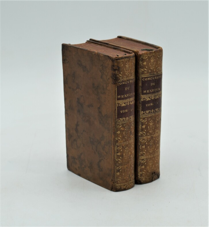
SOLIS (Antoine de).
Histoire de la Conqueste du Mexique, ou de la Nouvelle Espagne, par Fernand Cortez, traduite de...par l'Auteur du Triumvirat. Cinquième édition .
Paris, Compagnie des Libraires, 1730 ; 2 volumes in-12 de 15 ffnch., 606 pp., 13 ffnch., 6 ffnch., 560 pp.,12 ff. Et illustré de 2 cartes ( Golfe du Mexique et environs du lac du Mexique) et 11 planches ,la plupart dépliantes (Vue du Rio de Canoas, l'Ile de Cuba au port St Jacques, vaisseaux de Cortez désagréés sur une plage, bataille dans la vallée d'Otumba, vue de Mexico, etc..), relié plein basane marbré , dos lisse orné avec pièces de titre et tomaison rouge , tranches rouges , quelques petits accidents et restaurations aux reliures , petit manque de papier au titre du tome 1 sans atteinte.
Bookseller reference : PHO-1238
|
|
|
SOLIS, DON ANTOINE DE.
Histoire de La Conquête du Mexique, ou de la Nouvelle Espagne, traduite de l’espagnol de Don Antoine de Solis
Paris, Jean Bouillerot, 1691. Édition originale in-4° (25x19,5cm), 16ff.-630pp.-12ff. , illustré de 2 cartes et 12 planches , la plupart dépliantes , relié plein veau époque , dos à nerfs orné avec titre , restauration au dos , mouillure en fin d’ouvrage.
Bookseller reference : PHO-1239

|
|
 Receive by email
 Download as PDF document
 RSS feed


