|
ADAM.
[ORLÉANS] Nouveau plan de la ville d'Orléans, en perspective cavalière. Dédié à Mr. le vicomte de Riccé, préfet du département du Loiret.
Orléans, Alphonse Gatineau, 1831. En deux feuilles jointes formant un plan de 588x 836 mm.
Bookseller reference : LBW-6868

|
|
|
Adam. Bujak
CRACOW: FROM THE AIR.(Signed By Deputy Mayor)
Inscribed to Tom Pendry (now Lord Pendry) from Cracow Deputy Mayor. No other marks or inscriptions. No creasing to covers or to spine. A very clean very tight copy with bright unmarked laminated boards and no bumping to corners. Unpaginated, ca 100pp. Lavishly illustrated guide to the sights of Cracow with detailed captions. Text in English.

|
|
|
ADC Maps
Adc the Map People Montgomery County Maryland : Street Map Book Montgomery County Md Street Map Book
paperback. Good. Access codes and supplements are not guaranteed with used items. May be an ex-library book. paperback
Bookseller reference : 0875304435.G ISBN : 0875304435 9780875304434

|
|
|
ADC Maps
New Castle County Delaware Street Map Book
Adc the Map People. paperback. Acceptable. 0x10x14. Adc the Map People paperback
Bookseller reference : 0875300901-4-35174056 ISBN : 0875300901 9780875300900
|
|
|
ADC Maps
New Castle County Delaware Street Map Book
Adc the Map People. paperback. Good. 0.1417 in x 13.9803 in x 10.2205 in. Pamphlet paperback. Cover and spine in good condition. Spine is tight. Pages are clean no markings notes or stains. Ships from Friends bookstore to benefit Beaverton Oregon library. Adc the Map People paperback
Bookseller reference : mon0000046862 ISBN : 0875300901 9780875300900
|
|
|
ADC Maps
New Castle County Delaware Street Map Book
paperback. Good. Access codes and supplements are not guaranteed with used items. May be an ex-library book. paperback
Bookseller reference : 0875300901.G ISBN : 0875300901 9780875300900
|
|
|
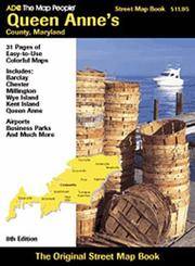
ADC Maps
Queen Anne's County Maryland Steet Map Book
paperback. Good. Access codes and supplements are not guaranteed with used items. May be an ex-library book. paperback
Bookseller reference : 0875304214.G ISBN : 0875304214 9780875304212
|
|
|
Ades, Dawn, (ed.) Quentin Bajac, Timothy Baum, Colin Browne, Whitney Chadwick, Robert Houle, sharon-Michi Kusunoki, Yves Le Fur, David Lomas, Marie Mauze, Andreas Neufert, Michael Richardson, Kurt Seligmann, Anthony Shelton, Anne Umland
The Colour of My Dreams: The Surrealist Revolution in Art
Book is brand new and in excellent condition in every respect. Binding is solid and square, covers have sharp corners, exterior shows no blemishes, text/interior is clean and free of marking of any kind. 336 pages with graphic endpapers, heavily illustrated throughout with large prints of paintings, sculpture, drawings, sketches, etc. Sections include: revolution by night ( Giorgio de Chirico, Max Ernest) The color of my dreams (Joan Miro, Andre Masson) Behind the screen (surrealism and film) Spaces of the unconscious, The surrealist object, Myths, maps, magic, The lure of the Pacific Northwest (Wolfgang Paalen's film, Kwakwaka'wakw headdress & Andre Breton, Anatomies of desire, etc.
|
|
|
Adler, C
C. Adler's Plan von Hamburg-Altona-Wandsbek und Umgebung. Beschreibender Führer mit vielseitigen geschichtlichen und statistischen Angaben. Ausführliches Namen-Verzeichniss der Strassen, Plätze etc.
Hamburg, C. Adler, ( 1896). 42 TextS., 1 Bl. Mit 1 mehrf. gefalt. farb. lithogr. Plan im Maßstab 1: 18.000 (ca. 65 x 90 cm.). Rotes OLn. mit dekorativer Schwarz- und Goldprägung.
Bookseller reference : 51224

|
|
|
Adolphe Germaine
Sudoku ninja niveau 4: Niveau 4 L'ultime combat
BRAVO 2026 322 pages 10 8x2x16 4cm. 2026. mass_market. 322 pages.
Bookseller reference : 500105976

|
|
|
Adolphe Germaine
Sudoku ninja niveau 4: Niveau 4 L'ultime combat
BRAVO 2026 322 pages 10 8x2x16 4cm. 2026. mass_market. 322 pages.
Bookseller reference : 500136606

|
|
|
adèle van wimille
Images d'archives du Nord
Edl 2005 in4. 2005. Cartonné. Images d'archives du Nord est un beau livre rassemblant 300 photographies et cartes postales anciennes pour la plupart inédites qui font revivre le Nord de la France de la fin du XIXe siècle au milieu du XXe siècle (1870-1940). L'ouvrage met en lumière les quatre piliers de l'industrie moderne de l'époque – charbon fer laine et coton – et offre un témoignage authentique à valeur humaine historique sociologique et économique
Bookseller reference : 100152308
|
|
|
AENISHÄNSLIN (Carlos).
[BRÉSIL/RIO de JANEIRO] Cidades de Rio de Janeiro e Nictheroy - Rio de Janeiro Central Monumental.
Rio de Janeiro, Grande Livraria editora Leite Ribeiro, 1922. Deux plans imprimés recto verso de 640 x 863 mm ; repliés dans une reliure éditeur contenant un guide de 72 pages."
Bookseller reference : LBW-8149

|
|
|
AFIF BAHNASSI.
Guide to Syria; with the compliments of Transtour. Photos by Mouhamed el Roumi, Nasri Akil, Vahe Chahinian, Riad kseibeh, et alli.
Fine English Paperback. 8vo. (19 x 12 cm). In English. 262 p., color ills. and b/w plans and maps. Guide to Syria; with the compliments of Transtour. Photos by Mouhamed el Roumi, Nasri Akil, Vahe Chahinian, Riad kseibeh, et alli. A richly illustrated Syrian guide for tourists printed in late 80s, including Damascus, Palmyra, Homs, Hama, Aleppo, the Euphrates valley, the coast from Tartous to Latakia, etc., with their detailed historical backgrounds. Revised second edition.
|
|
|
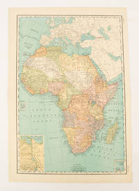
AFRICA MAP.
Africa.
New York.: Rand McNally & Co. 1899. Printed colour map 36.3 x 24.3 cm inset map of the Suez Canal and two smaller insets of the Cardagos Crayos Islands Mascarene Islands and Cape Verde Islands central fold and on the verso a printed panel listing the countries in Africa with their territorial governance area and population lower corner creased at the outer margin but in very good condition. An interesting late nineteenth-century map noting colonial governance. . Rand, McNally & Co. unknown
Bookseller reference : 174902
|
|
|
AFRICA - JAILLOT, H./ BRION DE LA TOUR.
L'Afrique divisée suivant l'estendüe de ses Principales Parties ou sont distinguès les uns des autres, Les Empires, Monarchies, Royaumes, Estats, et Peuples...Corrigées et augmentée par Mr. Brion.
Paris, chez le Sr Desnos, (ca 1783). 46,5x64,5 cm. Engraved map of Africa with the Mediterranean Sea at north. Contemporary handcoloured. Cartouche uncoloured. A few tears showing in right grade-scale, no loss.
|
|
|
AFRICA - JAILLOT, H./ BRION DE LA TOUR.
L'Afrique divisée suivant l'estendüe de ses Principales Parties ou sont distinguès les uns des autres, Les Empires, Monarchies, Royaumes, Estats, et Peuples...Corrigées et augmentée par Mr. Brion.
Paris, chez le Sr Desnos, (ca 1783). 46,5x64,5 cm. Engraved map of Africa with the Mediterranean Sea at north. Contemporary handcoloured. Cartouche uncoloured. A few tears showing in right grade-scale, no loss.
Bookseller reference : 25416
|
|
|
AFRIQUE AUSTRALE par Elisée RECLUS
L'Afrique australe. Description mise à jour par Onésime RECLUS contenant 25 cartes et 3 cartes en couleurs (sur planches dépliantes).
Ed. Hachette 1901. Bel exemplaire broché, couverture rempliée d'éd., fort et gd in-8 non ébarbé, 358 pages sur vergé cartonné + planches.
Bookseller reference : AUB-6125
|
|
|
AFRIQUE...
Atlas Levasseur. Carte entour?e de vignettes grav?es.
Une feuille 36x50 cm. L?g?rement d?fra?chie. D?chirure r?par?e en marge.
|
|
|
AFRIQUE...
Carte muette pour exercices g?ographiques au 1/25 000 000?. (Remplie par un ?l?ve). Dress?e par A. Meissas et A. Michelot.
Une feuille 64x49 cm. D?fra?chie.
|
|
|
AG MAPS
MAP OF HINDLEY GREEN 1906
Great Britain: Alan Godfrey Maps. Very Good. 2010. 1847843522 Old Ordnance Survey Maps MAP OF HINDLEY GREEN 1906 . Alan Godfrey Maps unknown
Bookseller reference : 103631 ISBN : 1847843522 9781847843524
|
|
|
AG MAPS
MAP OF HOPWOOD HALL & THORNHAM 1907
Great Britain: Alan Godfrey Maps. Very Good. 2013. 1847846580 Old Ordannce Survey Maps MAP OF HOPWOOD HALL & THORNHAM 1907 . Alan Godfrey Maps unknown
Bookseller reference : 103691 ISBN : 1847846580 9781847846587
|
|
|
AGASSIZ Mme et M. Louis; VOGELI Félix (trad.):
Voyage au Brésil.
Paris, Hachette, 1869. Grand in-8 de XII-532 pages, demi-chagrin rouge, dos à 4 nerfs orné de caissons et filets dorés, plats de percaline rouge, décorés de filets à froid, tranches dorées.
Bookseller reference : 14916

|
|
|
Agatha Christie - Les Années 1936-1937.
Abc contre Poirot - Cartes sur Table - Meurtre en Mésopotamie - Mort sur le Nil - Le Miroir du Mort - Témoin Muet.
- Le Club, 2001 Fort Volume au format 12.5 x19 cm, reliure pleine toile titrée en doré en creux sous jaquette jaune et noire, bel exemplaire, 1344 pages.Présentation de Jacques Baudou Bibliographie filmographie de Jean-Jacques Schléret. Volume 5 de la collection: « Les années 1936-1937 »
Bookseller reference : 12315

|
|
|
AI. Slusarouque Maps A. I.
Roadmap to lost mines and buried treasures of California
Van Nuys: Varna Enterprises 1971. Paperback. Very Good. Folded map. color both sides ; sheet 63 x 93 cm Varna Enterprises, paperback
Bookseller reference : 25-2035
|
|
|
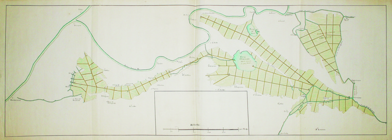
AIGUES-MORTES. MANUSCRIT.
[Carte des marais et canaux entre Arles et Aigues-Mortes].
[circa 1750]. En 2 feuilles jointes de 0,39 x 1,12 m.
Bookseller reference : LBW-4159
|
|
|
AIGUES-MORTES. MANUSCRIT.
[Fort de Peccais et marais salant de l’Abbé].
[circa 1720]. 430 x 384 mm.
Bookseller reference : LBW-4143

|
|
|
AIGUES-MORTES. MANUSCRIT.
Plan géométrique du domaine de Labadier appartenant à Mrs les héritiers de Louis Mourgues.
[circa 1840]. 543 x 725 mm, sur papier calque et monté sur papier.
Bookseller reference : LBW-4153

|
|
|
AIN
Carte d?partementale couleurs au 1/200 000?.
Une feuille 55x74 cm.
|
|
|
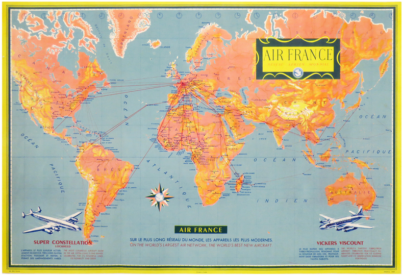
AIR FRANCE.
AIR FRANCE. Réseau Aérien Mondial.
Paris, Perceval, 1956. Lithographie en couleurs de 477 x 704 mm.
Bookseller reference : LBW-3313
|
|
|
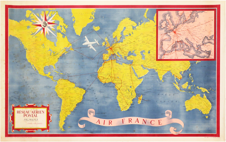
AIR FRANCE.
Réseau Aérien Postal. Air France.
Paris, Perceval, 1948. Lithographie en couleurs de 585 x 955 mm.
Bookseller reference : LBW-3312
|
|
|
Air France:
Certificat de passage du Pôle & de la ligne de changement de date / Certificate of crossing the North Pole and the date line.
Air France, 1967. Beau certificat émis par Air France, daté de 1967, cuvette, avec enveloppe nominative. Belles illustrations modernistes années 60. Quelques défauts à l'enveloppe, le certificat est en très bon état.
Bookseller reference : 24858

|
|
|
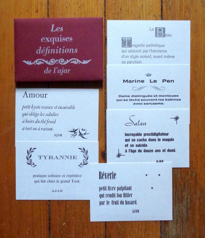
AJAR:
Les exquises définitions de l'ajar.
l'AJAR / L'atelier du Cadratin, 2012. 6 cartes postales - au format carte postale, faisons simple - sous pochette bordeaux avec titre argenté. A l'état de neuf.
Bookseller reference : 6334
|
|
|
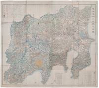
AKIYAMA EINEN OR NAGATOSHI .
富士見十三州輿地全圖. Fujimi Jūsanshū yochi zenzu. Map of the Thirteen Provinces From Where Mt. Fuji Is Visible.
Shūseidō 衆星堂. Reprint. Tenpō 14 1843. Large folding handcoloured map of the thirteen provinces from which Mt. Fuji can be viewed. 159 x 178cm. Folds into paper covered card covers measuring 40 x 24cm. Title label upper cover. A little browning along folds occasional spotting and soiling. A little worming causing approximately 1cm of loss in places. Two chops in lower section. A very striking and attractive map. This very large handsome map is a detailed map of the thirteen provinces from which one can see Mt. Fuji. Provinces shown are the eight provinces of the Kantō region Sagami 相模 Musashi 武蔵 Kazusa 上総 Shimofusa 下総 Awa 安房 Kōzuke 上野 Shimotsuke 下野 and Hitachi 常陸 and five other provinces Izu 伊豆 Suruga 駿河 Tōtōmi 遠江 Kai 甲斐 and Shinano 信濃. The map offers a large amount of detailed information such as province and county borders rivers high ways post towns checkpoints villages and scenic spots. <br> <br>The cartographer Akiyama Einen or Nagatoshi 秋山永年 came from Edo and the editor Funakoshi Seizō 船越清蔵 studio name: Shugu 守愚 1805-62 a Confucian scholar from Nagato Province now the western half of present-day Yamaguchi Prefecture. A dedication by Funahashi Akira 舟橋徴 is dated 1843. . Shūseidō 衆星堂 unknown
Bookseller reference : 159850
|
|
|
Akiyama, C.; Akiyama, N.
Learn Japanese the Fast and Fun Way (Fast and Fun Way Language Bks.)
234 pages plus vocabulary cards. The activity kit that makes learning a language quick and easy! Complete with maps, puzzles, and quizzes. Hundreds of amusing illustrations. Please note: does not include pull-out dictionary. First half of book has pencil markings in answer blanks. Light wear. Nice copy. Book
|
|
|
AL IDRISI - Miller, Konrad
Weltkarte des Arabers Idrisi vom Jahre 1154. Neudruck des 1928 erschienen Werkes.
Brockhaus / Antiquarium Stuttgart 1981. 22 Textseiten und eine vielfach gefaltete, farbige Karte, gefalzt in 3 Teilen. (linker Teil, mittlerer Teil und rechter Teil) zusammen in Original-Leinwand-Einband mit farbig mont. Abbildung. (Geringe Gebrauchsspuren. Einband etwas randfleckig) 33x25,5 cm
Bookseller reference : 146393

|
|
|
ALAIN BRÊTHES ( BRÊTHE )
L'INTERPRETATION DES ARCANES MAJEURS
Broché - 15,5 x 25 - 308 pp - année 2001 - Editions Oriane - illustrations
Bookseller reference : 16521

|
|
|
Alain Marc Adolphe Germaine
Sudoku ninja niveau 1: L'éveil du dragon
BRAVO 2026 322 pages 10 8x2 2x16 4cm. 2026. mass_market. 322 pages.
Bookseller reference : 500106015

|
|
|
Alain Marc Adolphe Germaine
Sudoku ninja niveau 1: L'éveil du dragon
BRAVO 2026 322 pages 10 8x2 2x16 4cm. 2026. mass_market. 322 pages.
Bookseller reference : 500136605

|
|
|
Albany, Maps
Britain and Ireland Road Atlas
Octopus Publishing Group. Used - Good. Ships from the UK. Used book that is in clean average condition without any missing pages. Octopus Publishing Group unknown
Bookseller reference : 51417027-20 ISBN : 0540083550 9780540083558
|
|
|
ALBARRAN (P.) et NEXON (R. de).-
Notre méthode de bridge. Edition revue, corrigée et augmentée 1948.
P., Grasset, 1950, in 8° broché, 249 pages (en partie non coupé) ; couverture illustrée en couleurs.
Bookseller reference : 27373
|
|
|
ALBARRAN Pierre
Le nouveau bridge pour tous.
Paris, Fayard, 1958 14 x 20, 396 pp., cartonnage + jaquette (défraîchie), bon état
Bookseller reference : 3206
|
|
|
ALBARRAN Pierre - DE NEXON Robert
Le bridge pour tous. Le jeu de la carte par José Le Dentu.
Cartonnage de l'éditeur. 380 pages.
|
|
|
ALBARRAN Pierre, Robert DE NEXON, José LE DENTU
Le nouveau bridge pour tous.
relié avec jacquette - 14,5x19,5 - 388 pp - 1965 - éditions ARTHEME FAYARD, Paris.Nouvelle édition revue et corrigée.
Bookseller reference : 6595
|
|
|
ALBARRAN-SVARC Simone et LE DENTU José
Nouveau mémento de bridge en 100 leçons, enchères naturelles.
Paris, Fayard, 1976 13 x 21, 108 pp., broché, bon état
Bookseller reference : 8288
|
|
|
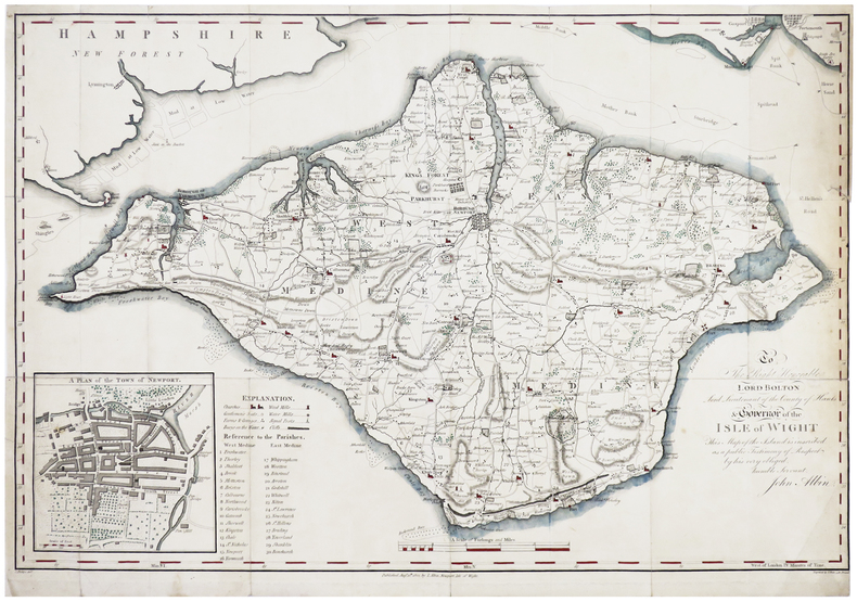
ALBIN (John).
[ÎLE de WIGHT] To the Right Honorable Lord Bolton, Lord Lieutenant of the county of Hants & governor of the isle of Wight.
Newport, Isle of Wight, J. Albin, 1802. 393 x 584 mm.
Bookseller reference : LBW-6386
|
|
|
ALBRIZZI Giambattista (Venezia 1698 - 1777)
Mappamondo o sia Descrizione Generale del Globo Terrestre ed Acquatico
Mappa del mondo tratta dall’Atlante Novissimo, edito da Giambattista Albrizzi, nel 1740 circa; una delle più interessanti e decorative carte del mondo che compaiono in un Atlante della metà del Settecento italiano. Elegante esempio della scuola italiana di cartografia commerciale; la decorazione intorno alla carta è stata realizzata da Giovanni Battista Piazzetta (1682-1754 ca.), la cui influenza è visibile nella successiva opera di Antonio Zatta e di altri editori veneziani del ‘700. Il contenuto cartografico della carta, che è tratto dal Mappe Monde di De l'Isle (1700), è circondato da allegorie femminili in ogni angolo che rappresentano i quattro continenti, delle quali il Piazzetta è il disegnatore e Giuliano Giampiccoli l’incisore. La mappa comprende una sfera armillare, le rotte dell'esploratore, la sconosciuta costa nord-occidentale dell'America, le proiezioni incomplete dell'Australia (ancora attaccata alla Nuova Guinea) e della Nuova Zelanda, la congiunzione della massa della Terra Asiatica che si estende verso l'Alaska e molti altri miti cartografici e proiezioni errate. Acquaforte, finemente colorata a mano, in ottime condizioni. Map of the World taken from Atlante Novissimo, published by Giambattista Albrizzi, circa 1740. Globe with allegorical representations of the four continents in the corners, surmounted by an armillary sphere. Striking example of Albrizzi's double hemipshere map of the World, one of the most interesting and decorative world maps to appear in a mid-18th Italian Century Atlas. An elegant example of the Italian school of commercial cartography, the art work around the map having been done by important Italian artist Giovanni Battista Piazzetta (ca. 1682-1754), whose influence can be seen in the subsequent work of Zatta and others. The cartographic content of the map, which is drawn from De l'Isle's Mappe Monde (1700), is secondary to the very beautiful, serene female figures in each corner representing the four continents. G. Batta Piaceta is shown as Inventor (left), and Guliano Giampicoli, as engraver (right). The map includes a finley executed armillary sphere, explorer's routes, unknown NW Coast of America, incomplete projections of Australia (still attached to New Guinea) and New Zealand, conjectural Asian Land mass extending toward Alaska and many other cartographic myths and misprojections. Copperplate with fine later hand colour, very good condition.

|
|
|
ALBUM DE CARTES POSTALES ILLUSTRÉES - RÉGIMENTS ANGLAIS
A.B.C. OF THE ARMY. Album de 123 Cartes postales illustrées représentant des régiments anglais ( Life Guards, Dragoon Guards, Horse Guards, Hussars, Lancers, Grenadiers, Irish Guards, Royal Scots, Fusilires, etc.....) en format cartes postales ou reproduction par photocopie de cartes postales pour quelques unes
2012 Cale et Polden LTD, Sansdate ( 20ème siècle) - Présentation des 123 cartes dans un album photo moderne - Illustrations en couleurs de chaque costume militaire (Voir photos)
Bookseller reference : 124283

|
|
|
Alden, John B.; Illustrated with Thirty-Eight Colored Maps, Diagrams, Tables ,Etc. [Illustrator]
Alden's Handy Atlas Of The World
NY: John B. Alden Publisher 1887 1887-01-01. Hardcover. Very Good. Bound in publisher's cloth. Hardcover. No dust jacket. Good binding and cover. Clean unmarked pages. 191 pages : color illustrations color maps ; 16 cm. "including one hundred and thirty-eight colored maps diagrams tables etc NY: John B. Alden, Publisher, 1887 hardcover
Bookseller reference : 2210070050
|
|
|
Alechinsky, Pierre
Writing book. Lithographie originale pour la carte de voeux de Aimé Maeght pour l'année 1981.
Paris Maeght 1980 aucune reliure 20 x 22,5 cm. 2ff. Lithographie originale en couleurs signée dans la planche. En page 2 la mention imprimée "Pierre Alechinsky, lithographie originale", en page 3 les voeux imprimés de Aimé Maeght et ses adresses à Paris, Zurich et Barcelone.
Bookseller reference : 3405

|
|
 Receive by email
 Download as PDF document
 RSS feed


