|
ANDRIVEAU-GOUJON (Eugène).
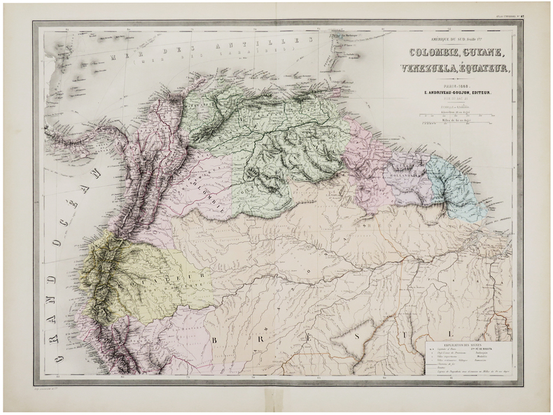
[COLOMBIE, GUYANE, VENEZUELA & ÉQUATEUR] Amérique du Sud. Feuille 1ère. Colombie, Guyane, Venezuela, Équateur.
Paris, E. Andriveau-Goujon, 1858. 470 x 635 mm.
Referentie van de boekhandelaar : LBW-6095
|
|
|
ANDRIVEAU-GOUJON (Eugène).
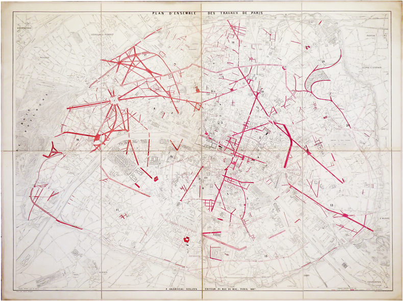
[TRAVAUX d'HAUSSMANN] Plan d'ensemble des travaux de Paris.
Paris, E. Andriveau-Goujon, 1867. En 8 sections montées sur toile et pliées, formant un plan de 0,99 x 1,30 m.
Referentie van de boekhandelaar : LBW-6483
|
|
|
ANDRIVEAU-GOUJON (Eugène).
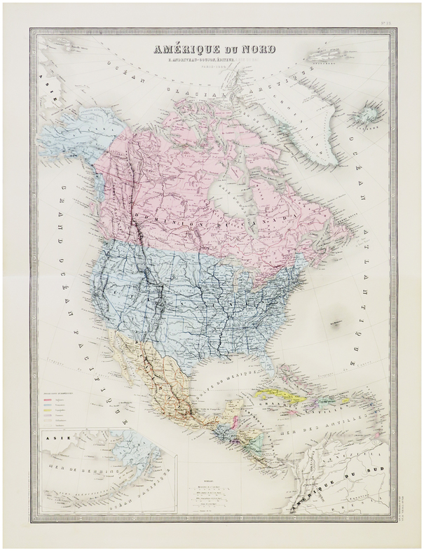
Amérique du Nord.
Paris, E. Andriveau-Goujon, 1880. 624 x 460 mm.
Referentie van de boekhandelaar : LBW-5799
|
|
|
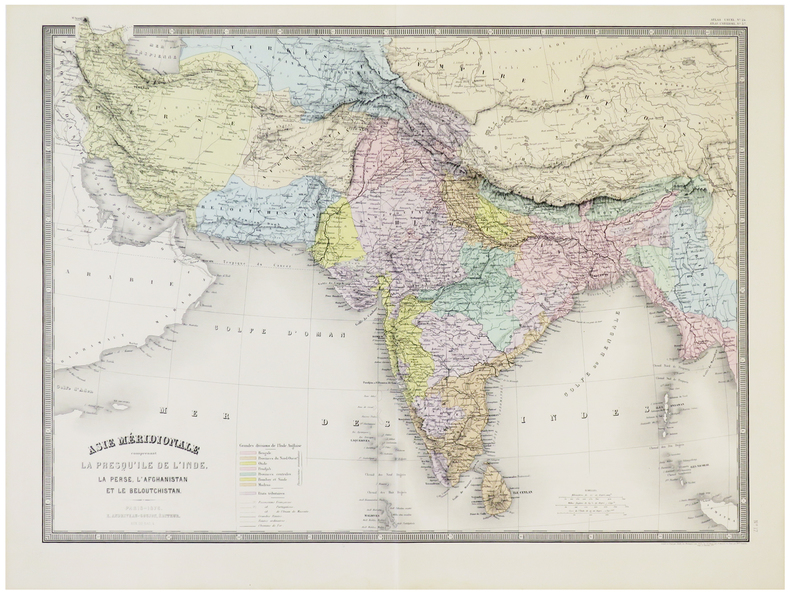
ANDRIVEAU-GOUJON (Eugène).
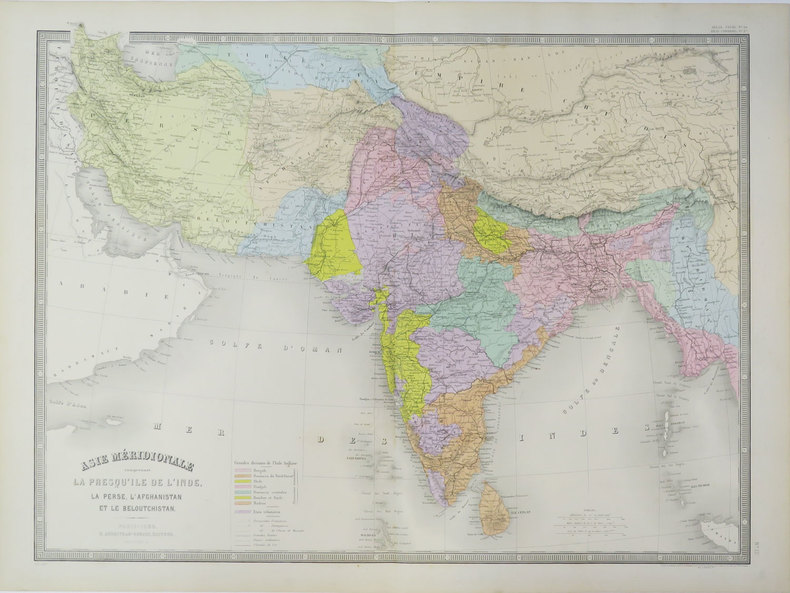
Asie méridionale comprenant la presqu'île de l'Inde, la Perse, l'Afghanistan et le Beloutchistan.
Paris, E. Andriveau-Goujon, 1889. 462 x 622 mm.
Referentie van de boekhandelaar : LBW-3621
|
|
|
ANDRIVEAU-GOUJON (Eugène).
Asie méridionale comprenant la presqu'île de l'Inde, la Perse, l'Afghanistan et le Beloutchistan.
Paris, E. Andriveau-Goujon, 1876. 463 x 628 mm.
Referentie van de boekhandelaar : LBW-5793
|
|
|
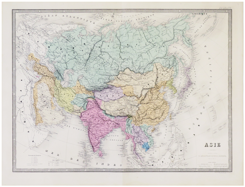
ANDRIVEAU-GOUJON (Eugène).
Asie.
Paris, E. Andriveau-Goujon, 1879. 463 x 627 mm.
Referentie van de boekhandelaar : LBW-5792
|
|
|
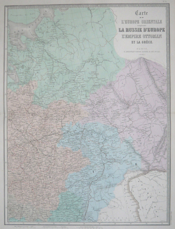
ANDRIVEAU-GOUJON (Eugène).
Carte de l'Europe orientale comprenant la Russie d'Europe, l'empire ottoman et la Grèce.
Paris, E. Andriveau-Goujon, 1863. En deux feuilles, chacune de 618 x 464 mm.
Referentie van de boekhandelaar : LBW061e9
|
|
|
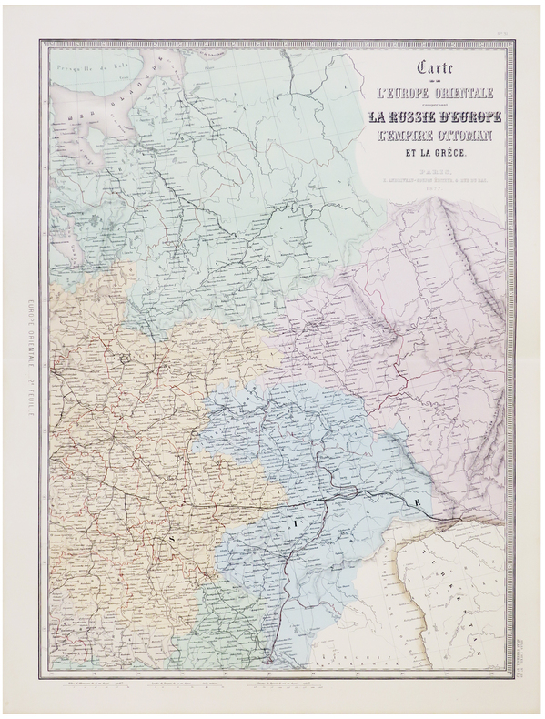
ANDRIVEAU-GOUJON (Eugène).
Carte de l'Europe orientale comprenant la Russie d'Europe, l'Empire ottoman et la Grèce.
Paris, E. Andriveau-Goujon, 1877. En quatre feuilles pouvant être jointes pour former une carte de 1,24 x 0,90 m.
Referentie van de boekhandelaar : LBW-5791
|
|
|
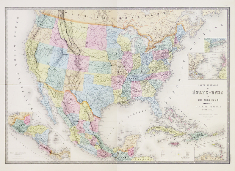
ANDRIVEAU-GOUJON (Eugène).
Carte générale des États-Unis et du Mexique comprenant l'Amérique Centrale et les Antilles.
Paris, E. Andriveau-Goujon, 1876. En deux feuilles pouvant être jointes pour former une carte de 623 x 900 mm.
Referentie van de boekhandelaar : LBW-5800
|
|
|
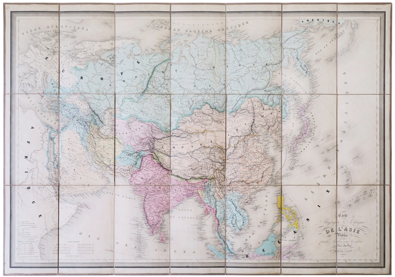
ANDRIVEAU-GOUJON (Eugène).
Carte physique & politique de l'Asie.
Paris, E. Andriveau-Goujon, 1861. En 21 sections montées sur toile et pliées, formant une carte de 673 x 943 mm, sous chemise et étui de papier marbré bleu, étiquette illustrée de l'éditeur E. Andriveau-Goujon au dos.
Referentie van de boekhandelaar : LBW-5129
|
|
|
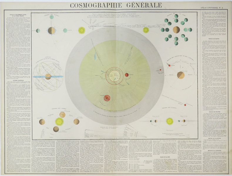
ANDRIVEAU-GOUJON (Eugène).
Cosmographie générale.
[circa 1880]. 513 x 669 mm.
Referentie van de boekhandelaar : LBW-3532
|
|
|
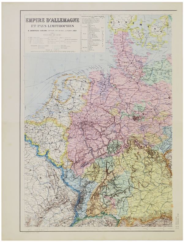
ANDRIVEAU-GOUJON (Eugène).
Empire d'Allemagne et pays limitrophes.
Paris, E. Andriveau-Goujon, 1880. En deux feuilles pouvant être jointes pour former une carte de 645 x 880 mm.
Referentie van de boekhandelaar : LBW-5790
|
|
|
ANDRIVEAU-GOUJON (Eugène).
Empire Ottoman.
Paris, E. Andriveau-Goujon, 1889. En deux feuilles pouvant être jointes pour former une carte de 655 x 900 mm.
Referentie van de boekhandelaar : LBW-3622

|
|
|
ANDRIVEAU-GOUJON (Eugène).
Environs de Paris dans un rayon de 30 kilomètres.
Paris, E. Andriveau-Goujon, 1881. En 36 sections montées sur toile et pliées, formant une carte de 0,83 x 1,05 m, monté dans une reliure en percaline de couleur verte avec titre en lettres dorées sur le premier plat ; étiquette de l'éditeur au dos du plan.
Referentie van de boekhandelaar : LBW-5659

|
|
|
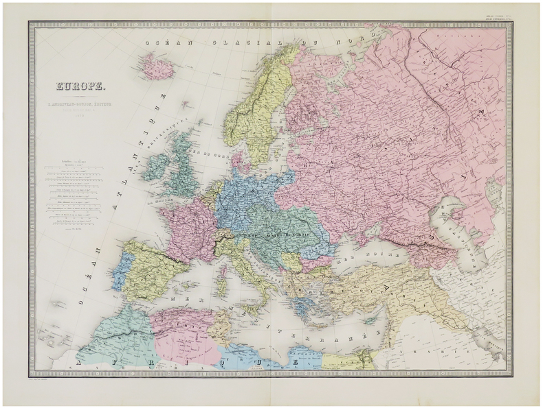
ANDRIVEAU-GOUJON (Eugène).
Europe.
Paris, E. Andriveau-Goujon, 1879. 462 x 626 mm.
Referentie van de boekhandelaar : LBW-5784
|
|
|
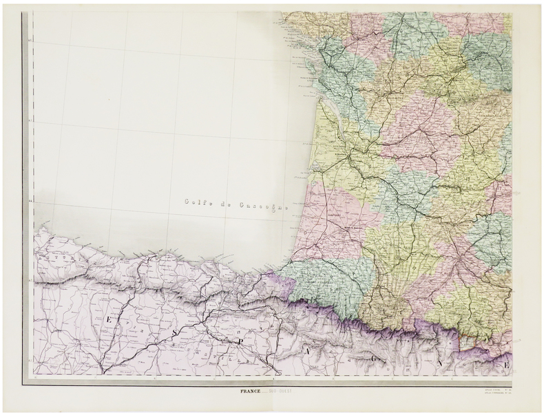
ANDRIVEAU-GOUJON (Eugène).
France.
Paris, E. Andriveau-Goujon, 1880. En quatre feuilles pouvant être jointes pour former une carte de 0,97 x 1,26 m.
Referentie van de boekhandelaar : LBW-5788
|
|
|
ANDRIVEAU-GOUJON (Eugène).
Italie.
Paris, E. Andriveau-Goujon, 1881. 622 x 460 mm.
Referentie van de boekhandelaar : LBW-5789

|
|
|
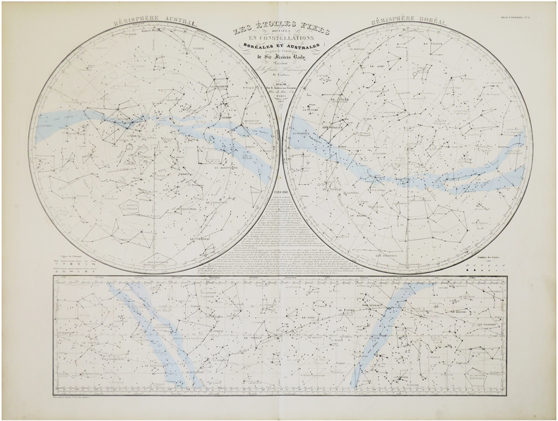
ANDRIVEAU-GOUJON (Eugène).
Les étoiles fixes divisées en constellations boréales et australes d'après le catalogue de Sir Francis Baily, Président de la Société Astronomique de Londres.
Paris, E. Andriveau-Goujon,. 1860 478 x 632 mm.
Referentie van de boekhandelaar : LBW-7847
|
|
|
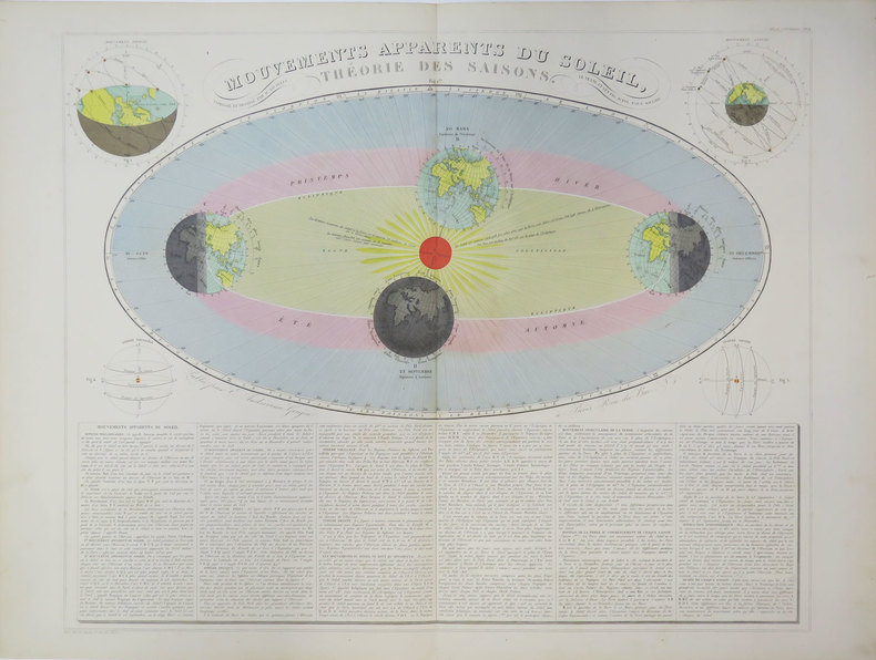
ANDRIVEAU-GOUJON (Eugène).
Mouvements apparents du Soleil, théorie des saisons.
Paris, E. Andriveau-Goujon, [circa 1880]. 470 x 587 mm.
Referentie van de boekhandelaar : LBW-3624
|
|
|
ANDRIVEAU-GOUJON (Eugène).
Pavillons et cocardes des principales puissances du globe d'après des documens officiels.
Paris, E. Andriveau-Goujon, 1860. 460 x 582 mm.
Referentie van de boekhandelaar : LBW-5148

|
|
|
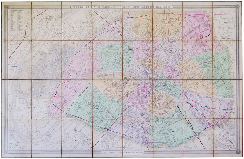
ANDRIVEAU-GOUJON (Eugène).
Plan géométral de Paris à l'échelle de 0.001 pour 10 mêtres (1/10,000).
Paris, E. Andriveau-Goujon, 1879. En 32 sections jointes et montées sur toile de 1,05 x 1,56 m ; étiquette de l'éditeur au dos.
Referentie van de boekhandelaar : LBW-5725
|
|
|
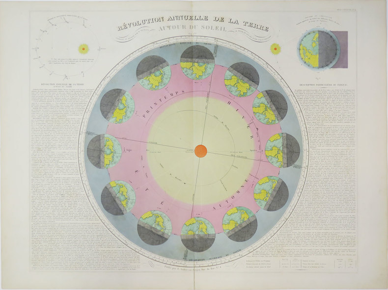
ANDRIVEAU-GOUJON (Eugène).
Révolution annuelle de la Terre autour du Soleil.
Paris, E. Andriveau-Goujon, [circa 1880]. 469 x 586 mm.
Referentie van de boekhandelaar : LBW-3623
|
|
|
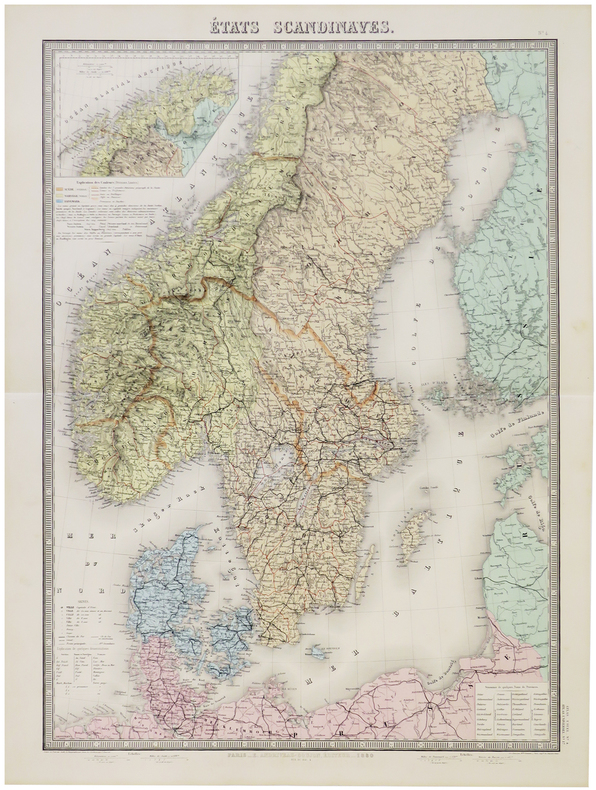
ANDRIVEAU-GOUJON (Eugène).
États scandinaves.
Paris, E. Andriveau-Goujon, 1880. 660 x 462 mm.
Referentie van de boekhandelaar : LBW-5786
|
|
|
ANDRIVEAU-GOUJON (J.)
Les Etoiles fixes divisées en constellations Boréales et Australes d'après le catalogue de Sir Francis Baily
1830 pliée. carte 63 x 88 cms. P. Andriveau-Goujon (ca. 1830)
Referentie van de boekhandelaar : 11804
|
|
|
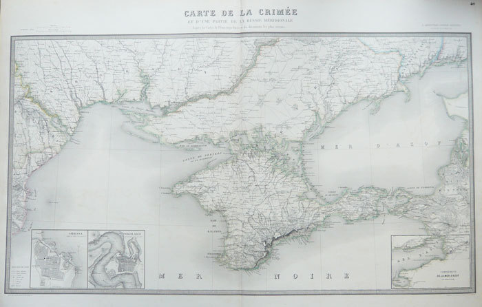
ANDRIVEAU-GOUJON (J.).
[UKRAINE] Carte de la Crimée et d'une partie de la Russie méridionale d'après les cartes de l'Etat-major russe et les documents les plus récents.
Paris, J. Andriveau-Goujon, 1856. 579 x 955 mm.
Referentie van de boekhandelaar : LBW-1084
|
|
|
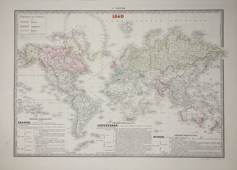
ANDRIVEAU-GOUJON (J.).
Carte comparative et synchronique de l'étendue territoriale des trois grandes puissances France, Angleterre, Russie, pendant le dernier siècle 1740-1840.
Paris, J. Andriveau-Goujon, 1840. Deux mappemondes de 432 mm x 592 mm et 430 x 605 mm.
Referentie van de boekhandelaar : LBW-2620
|
|
|
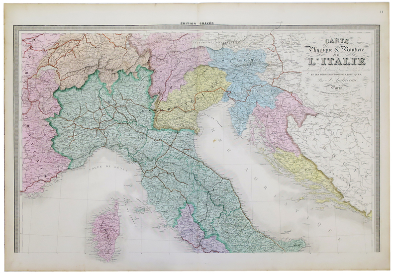
ANDRIVEAU-GOUJON (J.).
Carte physique et routière de l'Italie indiquant les distances d'un relais à l'autre et les dernières divisions politiques.
Paris, E. Andriveau-Goujon, 1863. En deux feuilles pouvant être jointes pour former une carte de 1,19 x 0,96 m.
Referentie van de boekhandelaar : LBW-5227
|
|
|
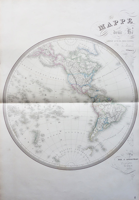
ANDRIVEAU-GOUJON (J.);
Mappemonde en deux hémisphères suivant l'état actuel des connaissances géographiques et les derniers voyages autour du monde.
Paris J. Andriveau-Goujon 1854 En deux feuilles non jointes pouvant former une carte d'environ 870 mm x 1,31 m.
Referentie van de boekhandelaar : LBW-1798
|
|
|
ANDRIVEAU-GOUJON (Jules).
Carte des fortifications de Paris.
Paris, J. Andriveau-Goujon, 1841. En 15 sections montées sur toile et repliées, formant une carte de 508 x 625 mm ; étiquette au dos de l'Atelier de Collage de Cartes Géographiques, Tableaux etc d'Auguste Logerot à Paris.
Referentie van de boekhandelaar : LBW-9017

|
|
|
ANDRIVEAU-GOUJON, E.
Plan géométral de Paris et de ses agrandissements à l'échelle d'un millimètre pour 10 m (1/10 000). [ Plan de Paris en couleurs - 1869 ]
1 carte entoilée dépliante sous chemise cartonnée et étui au format 104 x 156 cm, en couleurs, E. Andriveau-Goujon, Paris, 1867 Rare et bon exemplaire de cette carte de Paris en grand format, nous présentant la capitale à la fin du Second Empire, à la veille du Siège de Paris et de la Commune (la chemise est abîmée, l'étui est en bon état). D'une échelle et d'un format supérieur aux autres productions d'Andriveau-Goujon, elle englobe l'intégralité de la boucle de la Seine avec Boulogne et son bois, jusqu'à Saint-Cloud et Suresnes. Français

|
|
|
ANDRIVEAU-GOUJON, E.
Plan géométral de Paris et de ses agrandissements à l'échelle d'un millimètre pour 10 m (1/10 000). [ Plan de Paris en couleurs - 1869 ]
1 carte entoilée dépliante sous chemise cartonnée et étui au format 104 x 156 cm, en couleurs, E. Andriveau-Goujon, Paris, 1867
Referentie van de boekhandelaar : 34688

|
|
|
ANEMA (Piek L.)
L'Amoureux.
In-8 allongé, 87p. Tout savoir sur la 7e lame du tarot. Nombreuses illustrations en noir dans le texte. A l'état de neuf.
|
|
|
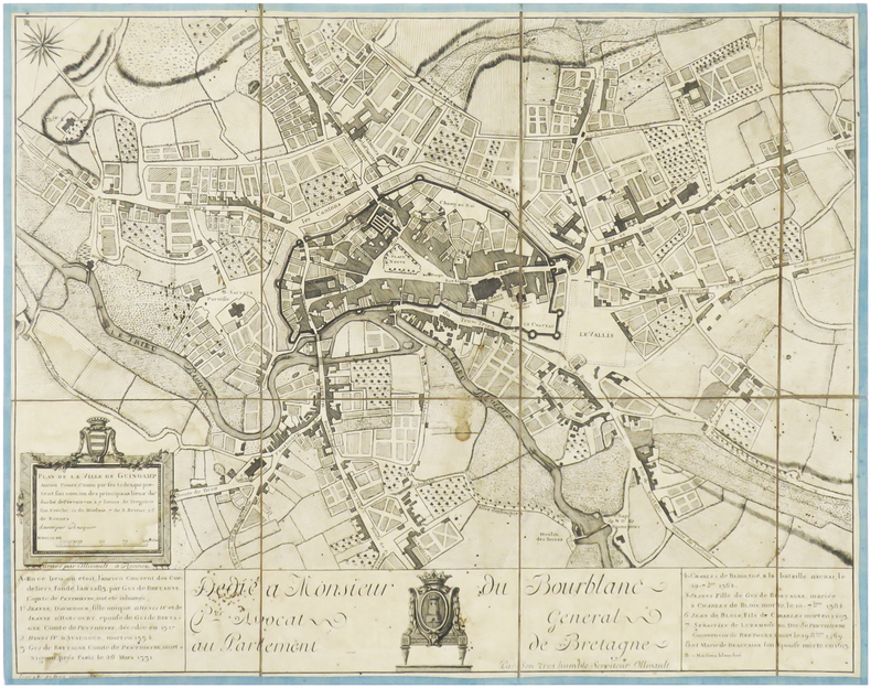
ANFRAY (Jean-François).
[GUINGAMP] Plan de la ville de Guingamp ancien comté, connu par ses toiles qui portent son nom, un des principaux lieux du duché de Penthièvre, à 7 lieues de Tréguier son évêché, 12 de Morlaix, 7 de S-Brieuc, 26 de Rennes.
Rennes, Ollivault, [circa 1770]. En 8 sections montées sur toile bordée de soie bleue et pliées, formant un plan de 371 x 475 mm.
Referentie van de boekhandelaar : LBW-3972
|
|
|
ANITA TIEDCKE [EMINE EREL], ((Head violinist of Ege Symphony Orchestra); MUHIDDIN [MUHITTIN] EREL, (1899-1986); SUNA & SEVIM ERELS, (Daughters of family, violinists).
[Collection of autograph letters, concert programs and other material of a German / Turkish violinist and her family].
Very Good German Original autograph letters signed, concert programs and one ticket of Bruno Walter and Jose Iturbi in 23 September 1932 by Anita Tiedcke, letters by and to Anita Tiedcke, Muhiddin Erel and Suna and Sevim Erels. Includes 54 concert programs, booklets and leaflets which some of them are handwritten, typewritten and mostly original prints. Some programs contains Anita Tiedcke's violin parts, early ones in Berlin (1930s), and later period ones in Istanbul. Especially typescript Istanbul programs (such as Aysegül Sarica's ones) are extremely rare and very important collection on Turkish history of classical music. One special designed hand written and drawn concert program titled "In Mozart Reich - Weihnachts Konzert gespielt von Nannerl u. Wolfgang Mozart. 24 autograph letters from and to all family members. Letters belong to Anita Tiedcke, are especially important for which include legal correspondences about Anita Tiedcke's conversion to Islam with her musician identity and musical history. Anita Tiedcke changed her name as 'Emine Erel' after conversion to Islam and marriage. Suna and Sevim Erels' letters also talk about music mostly. They are written in German usually, but some of them are in Turkish. Also the collection contains some book lists, catalogues. Anita Tiedcke completed her musical education at the Conservatory of Hamburg with the violonist Erika Besserer. After her marriage to Muhiddin Erel, she continued her musical studies in Istanbul and worked as an instructor at the Municipal Conservatory. In 1945, she was appointed as the mayor of the Istanbul Municipal Symphony Orchestra. The couple had two daughters, Suna and Sevin. Suna Erel was not content with the conservatory, but she also graduated from the Münch Hochschule für Musik Academy. Professor Suna Erel, who worked at Mimar Sinan University for many years, retired 8 years ago. For his achievements, the German government awarded Suna Erel the Beethoven medal. Muhiddin Erel was a Turkish professor and doctor. He was the founder of Ege University Medicine Faculty in 1955. Extremely rare and fine collection.
|
|
|
Ankcorn, Robert Compton-Davies, Ruby A-Z Maps
-Z Birmingham Hidden Walks: Discover 20 Routes In And Around The City
Harpercollins Publishers 2022. Paperback / Softback. New. 128 pages. 7.01x4.96x0.47 inches. Harpercollins Publishers paperback
Referentie van de boekhandelaar : __0008496307 ISBN : 0008496307 9780008496302

|
|
|
Anne Morrow Lindbergh; Charles A. Lindbergh (fwd. & maps).
Dust Jacket for Listen! The Wind! Price of $1.29 on flap. Original First Edition.
New York: Harcourt Brace 1938. Dust Jacket Only. 12mo. DJ Good with marginal tears at tail of spine minor staining inside DJ corners clipped. Original First Edition. New York: Harcourt Brace, 1938. unknown
Referentie van de boekhandelaar : 63-6396

|
|
|
Anne Morrow Lindbergh (maps by Charles A. Lindbergh)
North to the Orient
New York: Harcourt Brace and Company 1935. Dust jacket missing Very Good condition. Edition: Third Printing. Binding: Original full cloth with blue lettering flat spine. Size: Small 4to Illustration: With profuse black and white illustrations. Category: Book Arctic & Antarctic Harcourt, Brace and Company hardcover
Referentie van de boekhandelaar : B3841
|
|
|
Anne Morrow Lindbergh~Charles A. Lindburgh (Maps)
North to the Orient
Harcourt Brace and Company. Collectible - Very Good. Illustrator: Lindbergh Charles A.1935 stated 1st slight stain to front cover foxing to eps former owner's pencil inscription to reverse of fep interior is clean and sound dj edgeworn and torn. Dust Jacket Condition: Good Harcourt, Brace and Company unknown
Referentie van de boekhandelaar : B17068-T
|
|
|
Anne Morrow Lindbergh
Le Monde vu de haut d'amérique en chine par le cercle polaire ( avec 2 photos et 20 cartes établies par charles lindbergh)
Librairie Plon 1936 267 pages in8. 1936. broché. 267 pages. Récit du voyage aérien d'Anne Morrow Lindbergh et de son mari Charles Lindbergh de l'Amérique à la Chine en passant par le cercle polaire illustré de photographies et de cartes établies par Charles Lindbergh. L'ouvrage publié en 1936 par la Librairie Plon décrit cette expédition aérienne à travers des régions extrêmes
Referentie van de boekhandelaar : 8741

|
|
|
Annie Lionnet
Tarot découverte & initiation
Taschen 2003 224 pages in-12 carré. 2003. Broché - illustrations couleurs. 224 pages.
Referentie van de boekhandelaar : 5321 ISBN : 382282481

|
|
|
ANNUAIRE DIDOT-BOTTIN 1937
Annuaire didot-bottin 1937. Guide du lecteur. Sommaires des volumes, Table alphab?tique. Atlas d?partemental et colonial. Tables seules, sans les annuaires correspondants.
1 volume reli? toile. 115 pages + 120 pages de cartes.
|
|
|
Anny Chamant Francis J.-P. Chamant
"Meilleur Souvenir de Marseille !" ( ouvrage tiré à 1000 exemplaires)
Philoffset éditions 1983 252 pages in4. 1983. Reliure Editeur avec jaquette. 252 pages. Ouvrage présentant une collection de cartes postales anciennes de Marseille publié en 1983. Il s'inscrit dans une collection éditoriale dédiée aux loisirs culturels et à la découverte du patrimoine local
Referentie van de boekhandelaar : 11731

|
|
|
Anon
Bonnie Scotland
Small mark inside rear cover and to last page. No inscriptions, no creasing to main covers, slight rubbing and creasing to oversize edges. A very clean very tight copy with bright unmarked boards. 32pp. A series of sepia photographs of the beautiful places of Scotland. Not dated, ca 1930s.

|
|
|
Anon
Guide Du Pneu Michelin Perigord Limousin, Quercy
Michelin travel guide with text in French. With many town maps and illustrations in the text. 195 pages. 260mm x 120mm. Wear to cover edges and corners with small tear in the middle of the spine. Top page corners a little dog-eared. Some slight browning and soiling to covers.
|
|
|
Anon
INDICATEUR EXACT DES RUES DE PARIS 1919
Paris: Thibault Fils 1919. Book. Good. Paperback. 24mo 8 x 12cm. Title page reads "NOUVEAU GUIDE DES RUES DE PARIS" 92 pages. Original red card covers with silver gilt lettering good with some general wear and rubbing a little marked. Contents good some pages creased at edges. A good copy. Thibault Fils Paperback
Referentie van de boekhandelaar : 011910
|
|
|
Anon
Johnston's New Premier Atlas of the World
Previous owners name and date at top of front free endpaper. Covers shelfworn and spine faded.
|
|
|
Anon
THE AMICABLE QUIXOTE OR ENTHUSIASM OF FRIENDSHIP 4 volumes
London: Printed for J. Walker 1788. Book. Very Good. Hardcover. First Edition. 12mo. A very good four volume set in contemporary full tree calf binding with double lettering pieces in red and green. Complete pp. iii-vii 1 222; 2 206; 2 238 & 2 198. No half-titles which may or may not be wanting but the pagination for the prelims to vol. I might suggest that one is required Very good bindings with a little rubbing a couple of volumes slightly chipped to the head/tail of the spines corners lightly bruised. Contents clean and tight manuscript Greek initials to title pages dated 1788 otherwise unmarked no foxing paper crisp. A very good set. A Rare Eighteenth Century Novel. We have managed to located just one other copy at auction in the last thirty years and that at Sotheby's sale of July 21 1993 where it made £1000 on the hammer though seemingly not such a nice copy. Referenced by: ESTC T068744. Printed for J. Walker Hardcover
Referentie van de boekhandelaar : 024356

|
|
|
Anonimo
Antiquae Urbis Perfecta et Nova Delineatio
Pianta archeologica a proiezione verticale con alzato, priva di data ed indicazioni editoriali. Si tratta di una fedele replica della pianta archeologica pubblicata da Nicolas van Aelst ed incisa da Ambrogio Brambilla, probabilmente edita a Roma tra la fine del ’500 e l’inizio del secolo successivo. Caldana sottolinea che “l’anonimo incisore è bravo quasi quanto l’autore dell’originale, le differenze sono minime, salvo le misure che nella copia sono leggermente inferiori; imitata persino la calligrafia dei toponimi meno che per alcuni, scritti in lettere maiuscole”. Dal punto di vista editoriale, l’esistenza di un esemplare con l’imprint di Gian Giacomo de Rossi, descritto da Hülsen (1933) nella raccolta del castello di Wolfegg, certifica che il rame fosse in possesso della tipografia romana. Sempre Caldana sostiene, ma senza fondamento, che la pianta fu fatta incidere da Giuseppe de Rossi nel 1637, in occasione della ristampa della pianta di Roma moderna. Crediamo invece che il rame sia più antico e che, come per molte lastre del secolo precedente, solo successivamente venga acquisito dalla tipografia de Rossi. In alto, lungo il bordo superiore, è inciso il titolo: ANTIQUAE URBIS PERFECTA ET NOVA DELINEATIO. Lungo il margine inferiore si trova una legenda numerica di 90 rimandi a luoghi e monumenti notabili distribuita, su quindici colonne. Orientazione nei quattro lati al centro con il nome dei punti cardinali: SEPTENTRIO, MERIDIES, OCCIDENS, ORIENS il nord è a sinistra. Nella tavola sono presenti ulteriori indicazioni toponomastiche. Acquaforte e bulino, privo di indicazioni editoriali. Esemplare nel primo stato di due, avanti l'indirizzo di De Rossi. Magnifico esemplare di questa rara pianta archeologica di Roma. In perfetto stato di conservazione. Bibliografia Bifolco-Ronca, Cartografia e topografia italiana del XVI secolo, p. 2368, tav. 1217, I/II; Caldana (2013): n. I.28; Hülsen (1915): pp. 55-56, VIIIc, n. 41; Hülsen (1933): p. 106, VIIIc, n. 41a; Scaccia Scarafoni (1939): p. 28, n. 24. Archaeological map with vertical projection with elevation, without date and printing details. It is a faithful replica of the map published by Nicolas van Aelst and engraved by Ambrogio Brambilla, probably published in Rome between the end of the 16th century and the beginning of the following century. Caldana underlines that "the anonymous engraver is almost as good as the author of the original, the differences are minimal, except for the measurements that in the copy are slightly smaller; even the calligraphy of the place names is imitated, less so for some, written in capital letters". From the editorial point of view, the existence of a copy with the imprint of Gian Giacomo de Rossi, described by Hülsen (1933) in the collection of Wolfegg Castle, certifies that the copper was in the possession of the Roman printing house. Caldana also maintains, but without foundation, that the map was engraved by Giuseppe de Rossi in 1637, on the occasion of the reprinting of the modern Rome map. We believe instead that the copper is older and that, as for many plates of the previous century, it was only later acquired by de Rossi's printing house. At the top, along the upper edge, is engraved the title: ANTIQUAE URBIS PERFECTA ET NOVA DELINEATIO. Along the lower margin there is a numerical legend of 90 references to notable places and monuments distributed on fifteen columns. Orientation on the four sides in the centre with the name of the cardinal points: SEPTENTRIO, MERIDIES, OCCIDENS, ORIENS the north is on the left. In the map there are further toponymic indications. Etching and engraving; exemple in the first state of two, before the De Rossi's address. Magnificent example of this rare archaeological map of Rome. In perfect state of conservation. Literature Bifolco-Ronca, Cartografia e topografia italiana del XVI secolo, p. 2368, tav. 1217, I/II; Caldana (2013): n. I.28; Hülsen (1915): pp. 55-56, VIIIc, n. 41; Hülsen (1933): p. 106, VIIIc, n. 41a; Scaccia Scarafoni (1939): p. 28, n. 24.

|
|
|
Anonimo
Panorama di Roma Capitale d'Italia dedicato a tutti i Corpi Istituzionali del Regno ai Municipi ed alla Guardia Nazionale
Veduta a proiezione obliqua presa da un ideale punto al di sopra della Porta del Popolo.Non abbiamo trovato notizie bibliografiche su questo rarissimo documento, probabilmente la prima rappresentazione di Roma, subito dopo la proclamazione a capitale d'Italia (21 gennaio 1871) data che costituisce un termine post quem per il presente panorama.L'opera è dedicata a "tutti i Corpi Istituzionali del Regno ai Municipi ed alla Guardia Nazionale Pubblicato a memoria del voto compiuto 1870", ovvero a tutte le forse armate che contribuirono alla presa di Roma del 20 settembre 1870.Lo stemma sabaudo del Regno d'Italia, la dedica alla Guardia Nazionale ci inducono a pensare che l'opera sia stata stampata a Torino. Una rubrica di 150 rimandi - stampata tipograficamente - completa questo rarissimo panorama.Non possiamo escludere che si tratti di una veduta disegnata da un pallone areostatico.Acquaforte e acquatinta, leggere abrasioni nella parte superiore, piccoli restauri visibili al verso, nel complesso in buono stato di conservazione. Bird's eye view taken from an ideal point above the Porta del Popolo.We have not found bibliographic information on this very rare document, probably the first representation of Rome, immediately after the proclamation as the capital of Italy (January 21, 1871) date which is the terminus post quem for the present panorama.The work is dedicated to "tutti i Corpi Istituzionali del Regno ai Municipi ed alla Guardia Nazionale Pubblicato a memoria del voto compiuto 1870", that is to say to all the perhaps armed forces that contributed to the taking of Rome on September 20, 1870.The Savoy coat of arms of the Kingdom of Italy, the dedication to the National Guard lead us to think that the work was printed in Turin. A column of 150 references - typographically printed - completes this very rare panorama.We cannot exclude that it is a view drawn by an aerostatic balloon.Etching and aquatint, slight abrasions in the upper part, small restorations visible on the reverse side, overall in good condition.

|
|
|
Anonimo
Pianta di Roma nel 1813 circa.
Interessante e rara pianta topografica di Roma su cui sono riportati gli interventi progettati dall'Ammiistrazione Francese, che riguardano l'ampliamento del porto di Ripetta, la realizzazione di muraglioni sul Tevere, la sistemazione di piazza del Popolo e la salita al Pincio.La pianta dipende dall'opera di Philippe Camille De Tournon, che la realizzò sotto l'amministrazione francese nel 1814 circa, ma venne pubblicata 15 anni dopo.A sinistra "Spiegazione di alcuni segni che si veggono nella pianta" e l'Indice dei monumenti più notevoli; a destra, l'elenco dei XIV RioniAcquaforte e bulino, impressa su 20 tavole di circa 15,7 x 14,4 cm, montate su tela, in ottimo stato di conservazione. Custodia originale in cartoncino rosso.Non censita nei principali repertori. Interesting and rare topographical map of Rome on which are shown the interventions planned by the French Administration, concerning the enlargement of the port of Ripetta, the construction of embankments on the Tiber, the arrangement of Piazza del Popolo and the ascent to the Pincio. The plan is based on the work of Philippe Camille De Tournon, who created it under the French administration in about 1814, but it was published 15 years later. On the left "Explanation of some signs that can be seen in the plan" and the Index of the most remarkable monuments; on the right, the list of the XIV Rioni Etching and engraving, printed on 20 plates of about 15.7 x 14.4 cm, mounted on canvas, in excellent condition. Original case in red cardboard. Marigliani, 231.

|
|
 De zoekresultaten per email ontvangen
 Zoekresultaten downloaden als PDF
 RSS feed


