|
|
|
Michelin Maps and Guides (Firm)
Great Britain/Ireland Atlas Spiral Michelin Tourist and Motoring Atlas
Michelin Maps and Guides Firm 2007-01-01. Spiral-bound. New. New. In shrink wrap. Looks like an interesting title! Michelin Maps and Guides (Firm) unknown
Referenz des Buchhändlers : Q-2067124188 ISBN : 2067124188 9782067124189

|
|
|
Michelin Maps and Guides
Michelin Eating Out in Pubs 2012: Great Britain & Ireland Good Food in Informal Surroundings Michelin Guide/Michelin
paperback. Good. Access codes and supplements are not guaranteed with used items. May be an ex-library book. paperback
Referenz des Buchhändlers : 2067166174.G ISBN : 2067166174 9782067166172

|
|
|
Michelin Maps and Guides (Firm)
Michelin the Green Guide Burgundy Jura Michelin Green Guides
Michelin Maps and Guides Firm 2006-01-01. Paperback. New. New. In shrink wrap. Looks like an interesting title! Michelin Maps and Guides (Firm) paperback
Referenz des Buchhändlers : Q-2067119222 ISBN : 2067119222 9782067119222

|
|
|
Michelin Maps & Guides
The MICHELIN guide London
hardcover. Good. Access codes and supplements are not guaranteed with used items. May be an ex-library book. hardcover
Referenz des Buchhändlers : 2067184997.G ISBN : 2067184997 9782067184992

|
|
|
Michelin Maps & Guides
The MICHELIN guide London
MICHELIN 2013-01-01. MICHELIN. hardcover. New. 4.53x0.87x7.48. Buy with confidence. Excellent Customer Service & Return policy. MICHELIN hardcover
Referenz des Buchhändlers : DADAX2067184997 ISBN : 2067184997 9782067184992
|
|
|
MICHELIN MAP EXETER - BARNSTAPLE
Michelin Map of the British Isles. No. 20. Exeter - Banstaple. [Scale 3.15 miles to an Inch.] A RARE SURVIVAL
8vo., folding coloured map on cloth measuring 18 x 42 inches (approx. 46 x 107 cms) folding in 20 panels to 9.25 x 4.5 inches (approx. 23 x 12 cms); wrappers lettered in red and black, some moderate age-soiling else a very good, b right, clean copy. VERY SCARCE IN THIS CONDITION.
|
|
|
MICHELIN MAP SOUTHAMPTON - BRIGHTON
Michelin Map of the British Isles. No. 21. Southampton - Brighton. [Scale 3.15 miles to an Inch.] A RARE SURVIVAL
8vo., folding coloured map on cloth measuring 18 x 42 inches (approx. 46 x 107 cms) folding in 20 panels to 9.25 x 4.5 inches (approx. 23 x 12 cms); wrappers lettered in red and black, some moderate age-soiling else a very good, b right, clean copy. VERY SCARCE IN THIS CONDITION.
|
|
|
MICHELOTTI, Giuseppe Teresio.
Ensayo Hydrografico do Piemonte. Por José Threzio Michelotti, antigo professor de mathematica na Universidade de Torim. Traduzido pello Padre Francisco Furtado de Mendonça. Oferescido a S.A.R. o Principe de Brasil, Regente de Portogal.
Roma, por Antonio Fulgoni, 1803. 4to. mayor; XV pp., 118 pp. y seis láminas plegadas, grabadas por Giovanni Battista Cipriani, una de ellas un gran mapa del Piamonte diseñado por Andrea Cattaneo. Encuadernación moderna en tela. Giuseppe Teresio Michelotti, de la saga turinesa de los Michelotti, ingenieros y arquitectos especialistas en Hidráulica, de renombre universal, era hermano de Ignazio Maria Lorenzo Michelotti (1764-1846) e hijos ambos de Francesco Domenico Michelotti (1710-1787). El último de los Michelotti, Giovanni, fue ya en nuestros dias uno de los grandes diseñadores de automóviles en la FIAT de Turín. La presente obra sobre el Piamonte y su hidrografía podría considerarse el mejor estudio existente sobre cuatro ríos y una ciudad, ó bien: una ciudad y cuatro rios.

|
|
|
MIDDLE EAST - MAP].
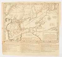
An exact map of the Crim formerly Taurica Chersonesus Part of Lesser Tartary the Sea of Asoph and the adjacent Country of the Kuban Tartars;.from the Charts sent by Generals Lucy and Munich in 1736 and 1737.
London.: The Gentleman's Magazine. circa1739. Engraved map 22.2 x 31.4 31.1 x 33 cm sheet size elaborate explanatory key in three columns at the foot original folds sealed 2 cm tear to the lower part of the inner margin one other small fold tear no loss inner margin of the key trimmed with some loss an original fault paper browned and spotted on the verso but an historic map in good condition. . [The Gentleman's Magazine]. unknown
Referenz des Buchhändlers : 174921
|
|
|
MIDTJYLLAND - MERCATOR, G.(GERHARD).
Iutia Septentrionalis.
(Amsterdam, 1595-1623). 29x40 cm. Kobberstukket kort over Nørrejylland, egnene omkring Limfjorden, vendsyssel i nord og til Horsens i syd samt Samsø. Samtidig håndkolorering. Bagsiden med latinsk tekst. Barokkartouche.
|
|
|
Midwest Plan Service
Private Water Systems Handbook
Book is in excellent condition. Binding is solid and square, covers have sharp corners, exterior shows no blemishes, text/interior is clean and free of marking of any kind. 72 pages with charts, graphs, tables, maps, mechanical drawings. Sections include: Water quantity, Water sources ( ground water, surface, wells, catchments and cisterns, -- roof cisterns --, ponds, springs) Pumps, (motors, special pumps -- rams windmills booster ) Pressure tanks and cotntrols, Piping, Water treatment (deteerfmining water quality, treatments and equipment -- disinfection , chlorine, heat, ultraviolet light, iodine), Chlorination, (shock, continuous, solution injection, management, residual, iron removal, nitrate and sulfate removal, softening, acid water) etc.

|
|
|
Miers, Richenda
Cumbria : County Companion
No marks or inscriptions. No creasing to covers, faint crease to spine. A very clean extremely tight copy with bright unmarked boards and no bumping to corners. 211pp. Complete guide to the county including detailed maps, town directory, leisure A-Z.

|
|
|
Miles Cartes
Say It Right Every Time: Master Confident Empathetic Communication for Difficult Conversations at Work and Home
Clear Vision Publishing 2026. Paperback. Very Good. May have limited writing in cover pages. Pages are unmarked. ~ ThriftBooks: Read More Spend Less.Dust jacket quality is not guaranteed. Clear Vision Publishing paperback
Referenz des Buchhändlers : G1806475502I4N00 ISBN : 1806475502 9781806475506
|
|
|
Miller, Marli B (Maps by Chelsea Feeney)
OREGON ROCKS! A GUIDE TO 60 AMAZING GEOLOGIC SITES
MissoulaMontana: Mountain Press Publishing 2022. Second Printing. Softcover. Near Fine. Perfectbound folio 9 in. x 8 1/4 in. A guide to 60 of the most compelling geologic sites in the state.with "destinations that span the state's geologic history from the Triassic marble at Oregon Caves to the 240 year-old lava dome on Mt. Hood. Covers Coast Range; Klamath Mountains; Cascade Range; Lava Plateaus; Blue Mountains; Basin and Range; With gGossary References and Index. Great maps and lovely color illustrations . 154 pages. Mountain Press Publishing unknown
Referenz des Buchhändlers : 88352 ISBN : 0878427031 9780878427031

|
|
|
Millmore, Paul
South Downs Way : National Trail Guide
Light dusty marks to top page edges. No other marks or inscriptions. Very minor creasing to covers, none to spine. Clean bright boards with no bumping to corners. A lovely clean crisp tight copy. The contents appear to be 'as new' and never used. 168pp.

|
|
|
MILLON, Rene (editor); R Bruce Drewitt and George L Cowgill (maps)
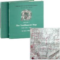
Urbanization at Teotihuacán Mexico: Volume I the Teotihuacán Map. Part I: Text and Part II: Maps in two volumes
Austin: University of Texas Press 1973. First Edition. Two quarto volumes 29.5cm. Part I in green cloth-covered boards; dustjacket; xvi34-1542pp; black-and-white photographic halftone illustrations throughout. Part II spiral-bound in green cloth; 147 numbered illustrations with printed acetate overlays; rear cover has attached folder with three large folding maps the largest "Map 3" measuring 190cm x120cm. Modest shelf-wear with light rubbing to board edges; light wear to dustwrapper text and contents uniformly clean and unmarked; Very Good to Near Fine. From the library of poet-translator-anthropologist Nathaniel Tarn with his printed bookplates to both volumes. <br /> <br /> Volume I complete in itself presents the most detailed site map ever completed of the great Mexican city of Teotihuacán. Further volumes in the series on ceramics and mortuary practices were added later. <br /> 88204. University of Texas Press unknown
Referenz des Buchhändlers : 88204
|
|
|
Mills, Anastasia R. (editor)
Fodor's Maine, Vermont, New Hampshire : Country Dining, B&Bs, Antiques and Mountain and Coastal Drives (3rd ed)
No marks or inscriptions. No creasing to covers or to spine. A very clean very tight copy with bright unmarked boards, minor indenting to upper front edge and no bumping to corners. 240pp. Travel guide to the USA's New England - Maine, Vermont, New Hampshire.

|
|
|
Millward, A.E.; Rosenmuller, M. (Appendix); Anderson, M.B.A. (Translator)
Southern Baffin Island: An Account of Exploration, Investigation and Settlement During the Past Fifty Years - with Appendix "The Crossing of Baffin Island to Foxe Basin by Bernard A. Hantzsch in 1910"
130 pages. Printed on glossy stock. Thirty-nine reproductions of black and white photos. Fifteen maps, four of which fold out. Heavily worn. Prior owner's lavishly handwritten details upon first blank leaf. Covers almost loose. Taped repairs to spine. Contains summaries of the work done, 1882-1928, by various expeditions, Church of England missions, the Royal Canadian Mounted Police, Dept. of the Interior and Geological Survey of Canada, in opening up the country, and providing new maps and information. [AB 2751] Book

|
|
|
Milner, Rev. Thomas.
THE GALLERY OF GEOGRAPHY: A PICTORIAL AND DESCRIPTIVE TOUR OF THE WORLD.
Two volumes. pp. xvii, 510; 511-956 + Plus 12 colored folding maps + Five steel engraved plates + Engraved illustrated title page. Numerous woodcut illustrations in the text. 8vo. Worn original full leather bindings. A thorough delight for the Victorian arm chair traveller. This American edition is rather scarce. **PRICE JUST REDUCED! W156
|
|
|
MINIATURE MAPS - (MÜLLER, JOHANN ULRICH).
Dess Neu=aussgefertigten Kleinen Atlantis Zweyter Theil/ oder Umständliche Beschreibung der noch übrigen Drey Erd=Theile/ Asiae, Africae und Americae, nach ihren verschiedenen Theilen/ Käyserthümern, Königreichen, Fürstenthümern.... Anbey auch mit der...
Frankfurt, Johann Philipp Andreae, 1702. 8vo. (18 x 11 cm.). Contemp. full calf. Richly gilt spine. Raised bands. Spine-ends repaired. (2),373,(59) pp. With 50 (of 64) fine half-page handcoloured maps (ca 65 x 78 mm), each with text. Maps ahead of the text. Added 6 maps in facsimile. Title-page in facsimile. Internally clean.
|
|
|
Ministère de l'Industrie
Carte des Richesses Minérales de la France établie par la Direction des Mines (Bureau de Documentation Minière) et le Bureau de Recherches Géologiques et Minières. Situation au 1er avril 1959
Carte entoilée au 1:1 000 000 dessinée sur le fond topographique de la carte de l'IGN, Ministère de l'Industrie, BRGM, Etablissements Veit, format 122 x 103 cm Bel exemplaire en parfait état Français

|
|
|
Minnesota Rivers Maps
Snake Upper Red and Minnesota Rivers Minnesota; Reservoirs at Sources of rock River Wisconsin and Illinois
Washington DC: U. S. Congress. Very Good. 1881. Pamphlet. Snake Upper Red and Minnesota Rivers Minnesota; Reservoirs at sources of Rock River Wisconsin and Illinois. Letter from the Secretary of War transmitting surveys .United States. War Department. 1881. 16 pages maps 2 folded ; 23 cm. Washington Govt. Print. Off. 1881. Disbound Pamphlet. The contents are nice and the 2 folding maps are bright and clean. . U. S. Congress unknown books
Referenz des Buchhändlers : 74181
|
|
|
Miquelon, Dale; Ingram, George C.; Morrison, William R.;
Canadian Historic Sites - Occasional Papers in Archaeology and History No. 4
188 pages. Includes the following papers: A Brief History of Lower Fort Garry; The Big House, Lower Fort Garry; Industrial and Agricultural Activities at Lower Fort Garry; The Sixth Regiment of Foot at Lower Fort Garry; The Second Battalion, Quebec Rifles, at Lower Fort Garry. Includes a variety of black and white illustrations and maps. Unmarked. Moderate wear. Book
|
|
|
Mission Brésilienne d'Expansion Economique
Brésil. Carte Politique et Economique [ Commerce International en 1906 et 1907 ]
Carte politique et économique publiée par la Mission brésilienne d'Expansion économique, échelle au 1 : 5 000 000, 1 carte format 83,5 x 90 cm, Aillaud & Cie, s.d. [ circa 1908 ] Belle carte politique et économique du Brésil à l'aube de la Première Guerre Mondiale. Bon état (qq. très petits frott., très bon état par ailleurs). Français

|
|
|
Mitscherlich, E.:
Geognostische Karte der vulkanischen Eifel. Farbige lithographische Karte von E. Mitscherlich.
48,5 x 59 cm. *Frühe Karte der geognostischen Erscheinungen der Eifel. - Zeigt das Gebiet zwischen Ormont, Jammelhoven, Beuren, und St. Thomas. Aus Mitscherlichs Werk: "Über die vulkanischen Erscheinungen in der Eifel". Mehrfache Falzspuren. Graphiken de
|
|
|
Mitsuhisa Takayanagi: Supervised by Historical Maps Co, Ltd
Kosenjo All 2 Volumes Top and Bottom
A5 1st edition with box history book company 1978. Soft Cover. Fine. Number of books: 1 A5 1st edition with box, history book company paperback
Referenz des Buchhändlers : 2081502112501891
|
|
|
Mitsumura Maps, Nire Publishing
Quarterly Flying Classroom 1.7.10.17.20-43.45 1981-1993 Supplementary Volume Creative Special 1992 30 volumes
Mitsumura Maps Nire Publishing 1993. Soft Cover. Fine. Number of books: 30 Mitsumura Maps, Nire Publishing paperback
Referenz des Buchhändlers : 2082402113507248
|
|
|
Mittelbach
Mittelbachs Karten: Amiens-Abbeville-St. Pol. - Blatt 2
Approximately 23" x 19". Undated but probably from the early 20th century. Clean and unmarked with light wear. Some age-toning. A quality copy. Map

|
|
|
Mittelbach
Mittelbachs Karten: Arras - Cambrai - Peronne - Laon - St. Quentin, Blatt 3
Approximately 23" x 19". Undated but probably from the early 20th century. Bit of writing on bottom edge of map. Moderate wear. Some age-toning. A sound copy. Map

|
|
|
Mittelbach
Mittelbachs Karten: Paris - Compiegne Soissons - Chateau - Thiery, Blatt 4
Approximately 23" x 19". Undated but probably from the early 20th century. Unmarked with moderate wear. Some age-toning. A sound copy. Map

|
|
|
Mizuno Koshi / Meiji Maps, Meiji Maps
Japanese Language Education Analysis Theory and Practice Out of Stock
Not Available 1986. Soft Cover. Fine. The book is in fine condition. Not Available paperback
Referenz des Buchhändlers : 2091202132900086
|
|
|
MODENE (Comte de).
Mémoires du Comte de MODENE, sur la Révolution de Naples de 1647. Troisième édition, publiée par J. - B. MIELLE.
Paris, Chez Félicien et Chatel, 1827. 2 volumes in-8, demi-chagrin rouge, dos ornés de filets dorés, 270 et 514 pages. Belle édition malgré une légère insolation sur les plats.
|
|
|
Modern Maps Hironobu Matsuda and others
Designing and manufacturing automation that can be done in any factory
Modern Maps Hironobu Matsuda and others 1973. Soft Cover. Fine. The book is in fine condition. Modern Maps Hironobu Matsuda and others paperback
Referenz des Buchhändlers : 2083002116204312
|
|
|
Modern Maps Masami Fukuoka
Earth Pressure Retaining Calculation Method and Examples for Field Engineers
Modern Maps Masami Fukuoka 1980. Soft Cover. Fine. The book is in fine condition. Modern Maps Masami Fukuoka paperback
Referenz des Buchhändlers : 2083002116202287
|
|
|
Moffat, Alistair
Edinburgh
No marks or inscriptions. No creasing to covers or to spine. A very clean very tight copy with bright unmarked boards and bumping to lower rear corner. 176pp. Essentially a book of lovely photographs presenting an up-to-date picture of the Scottish capital accompanied by a short history.

|
|
|
Moffat, Alistair
Fife
No marks or inscriptions. No creasing to covers or to spine. A very clean very tight copy with bright unmarked boards and extremely minor bumping to spine top and lower rear corner. 176pp. Essentially a book of lovely photographs presenting an up-to-date picture of the Scottish region of Fife between the Forth and the Tay accompanied by a short history.

|
|
|
MOGALLI Niccolò- PETROSCHI Giovanni
Carta topografica delle Antichità di Roma…secondo il Giro metodico usato già dall'AB. Ridolfino Venuti…
Pianta topografica delle vestigia dell'antica Roma, a proiezione e figurazione verticale, pubblicata nel 1763 nell'opera di Ridolfino Venuti "Accurata, e succinta descrizione topografica delle antichità di Roma".Incisa da Niccolò Mogalli e Giovanni Petroschi, su disegno di R. Venuti.Le indicazioni toponomastiche in parte sono riportate nella pianta, in parte in una rubrica di 77 numeri posta ai lati. In basso, a destra, la firma degli incisori. La seconda edizione della lastra, reca la data 1823.Incisione su rame, in ottimo stato di conservazione. Pianta topografica delle vestigia dell'antica Roma, a proiezione e figurazione verticale, pubblicata nel 1763 nell'opera di Ridolfino Venuti "Accurata, e succinta descrizione topografica delle antichità di Roma".Incisa da Niccolò Mogalli e Giovanni Petroschi, su disegno di R. Venuti.Le indicazioni toponomastiche in parte sono riportate nella pianta, in parte in una rubrica di 77 numeri posta ai lati. In basso, a destra, la firma degli incisori. La seconda edizione della lastra, reca la data 1823.Incisione su rame, in ottimo stato di conservazione. Frutaz, Le piante di Roma, XXXVIII; L. Schudt, Le guide di Roma, p. 405, n. 769; Caldana (2013): p. 107, n. I.64.

|
|
|
MOISEL, Max
Karte von Kamerun, bearbeitet von M. Moisel H 1 , 2 : Kribi [ Echelle 1 / 300.000 ]
1 carte dépliante format 64 x 99,5 cm, Konstruiert u. gezeichnet v. W. Bobzin u. C. Jurisch. Abgeschlossen 15 August 1911 Carte allemande de 1911, couvrant le territoire allant de Kribi à Sangmélima. Etat très satisfaisant (petits accrocs en marge). Français

|
|
|
MOITHEY, M. ; [ MOITHEY, Maurille-Anthoine ]
Dictionnaire hydrographique de la France [ Edition originale ] Ou nomenclature des Fleuves, Rivières, Ruisseaux et Canaux ; le lieu où ils prennent leurs sources, leurs embouchures et confluents, leur étendue eû égard à leurs sinuosités, leur commerce flottable ou navigable avec les villes qu'ils arrosent, suivie d'une division hydrographique de ce royaume et d'une description de ses ports &c. enrichie d'une carte de la France relative à l'objet
1 vol. in-8 reliure de l'époque demi-basane marron, Chez L'auteur et Chez Prevost, Le Roi, Paris, 1787, 2 ff., VIII-221 pp. 1 f., 4 pp. avec une grande carte dépliante en couleurs (format 58 x 510 cm) Titre complet : Dictionnaire hydrographique de la France [ Edition originale ] Ou nomneclature des Fleuves, Rivières, Ruisseaux et Canaux ; le lieu où ils prennent leurs sources, leurs embouchures et confluents, leur étendue eû égard à leurs sinuosités, leur commerce flottable ou navigable avec les villes qu'ils arrosent, suivie d'une division hydrographique de ce royaume et d'une description de ses ports &c. enrichie d'une carte de la France relative à l'objet Cette édition originale est bien complète de la belle grande carte en couleurs intitulée : "Carte Physique et Hydrographique de la France ou l'on trouve les principales Chaînes de Montagnes, le cours des Fleuves de France et de toutes les Rivières qui y affluent, avec l'indication des lieux ouelles sont navigables, les Canaux existans ; les Villes riveraines, les Ports et les principaux Ponts, Divisée en ses Gouvernemens et Provinces, dressée d'après la Carte générale de France de l'Académie". Etat satisfaisant (reliure très fort. usée, cachet ancien de séminaire, très bon état intérieur). Ingénieur géographe du Roi et professeur de mathématiques des pages du Prince et de la Princesse de Conti, Maurille-Anthoine Moithey (1732-1805) se fit libraire et éditeur pour diffuser plusieurs travaux géographiques et cartographiques. Français

|
|
|
MOLINI Giuseppe (Attivo a Firenze inizio '800)
Hemisphere Maritime /Hemisphere Terrestre
Carta geografica del mondo con proiezione gnomonica, pubblicata a Firenze nel 1806/7. Incisione in rame, coloritura coeva, in perfette condizioni. Rara.Mappa tratta dall'Atlas historique, chronologique, geographique et genealogique.Questa rara mappa del mondo mostra due emisferi e i percorsi di viaggio della Famiglia Polo (1230-1295), degli esploratori Magellano e Pigafetta (1519-1522), James Cook (1776-1780) e George Vancouver (1790-1795).Sono rappresentati il "Mare dell'Ovest" e un passaggio nord-ovest molto chiaramente delineato.La mappa fu pubblicata da Giuseppe Molini, attivo a Firenze all'inizio del XIX secolo. Map taken from Atlas historique, chronologique, geographique et genealogique.This very rare world map shows two hemispheres and displays the travel routes of the Polo Family (1230-1295), the explorers Magellan and Pigafetta (1519-1522), James Cook (1776-1780) and George Vancouver (1790-1795) in colored lines. The mythical "Sea of the West" is shows in detail in the northwest of the continent. It also shows a very clearly delineated Northwest Passage.The map was published by Giuseppe Molini, who was active in Florence in early 19th centery. He teamed with Landi to publish several maps and atlases, most of them copied from works of other French cartographers including Brue and Le Sage.

|
|
|
Molony, Eileen (editor)
Portraits of Rivers
Ex Boots library book with marks only to covers, none to contents. No creasing to covers or to spine. A very clean very tight copy with maroon boards and no bumping to corners. 139pp. With features on eleven British rivers by eleven well-known authors, including the Itchen by Brian Vesey-Fitzgerald, the Severn by Brian Waters and the Thames by Laurie Lee.

|
|
|
Mombert, J. I.
AN AUTHENTIC HISTORY OF LANCASTER COUNTY, IN THE STATE OF PENNSYLVANIA.
pp. vii, 617, 175 + Plus large folding frontis map, lithographed and engraved illustrations and several maps, one in color. Folding frontis map has old tape repair. Inked ownership of A. C. Kepler, July 1869. His initials on title page. Text very slightly browned. Large 8vo. Original full leather binding. Boards detached with some loss on spine. Hardbound. Howes M 720. PA 45 rear
|
|
|
MONALDINI Venanzio (attivo 1765 - 1829 circa)
Nuova Pianta di Roma Moderna estratta dalla grande del Nolli corretta ed accresciuta de' nomi delle contrate indicati al lor
Pianta della città di Roma basata sulla mappa di Giovanni Battista Nolli (1692-1756). Incisione di Pietro Ruga. Con una legenda (I - XIV), scala e titolo "Nuova pianta di Roma moderna estratta dalla grande del Nolli: nell'angolo in basso a destra, corretta ed accresciuta de 'nomi delle contrade indicate al loro rispettivo sito".Include 4 piani inserti del Pantheon, della basilica di San Paolo, del mausoleo di Santa Costanza e della chiesa di San Lorenzo.Si tratta della prima edizione della pianta che il Ruga disegnò ed incise per l'editore Venanzio Monaldini, il cui successo e diffusione è testimoniato dal fatto che venne ristampata in successive sei edizioni fino al 1843. Sul lato destro sono raffigurate le piante del Mausoleo di Santa Costanza, Basilica di San Paolo e Panthon; in alto a destra San Lorenzo fuori le mura. IN basso a destra, sopra al titolo, è inciso l'elenco dei 14 Rioni. Nella pianta, assai dettagliata, da notare l'emiciclo di Piazza del Popolo realizzato solo per metà.Incisione in rame, in 20 sezioni posate su lino e più volte ripiegate, racchiuse in astuccio in cartonato coevo. Ottime condizioni. Town plan of Rome based on map by Giovanni Battista Nolli, ( fl. 1692-1756). Engraved by Pietro Ruga. With a key (I - XIV), scale and text "Nuova pianta di Roma moderna estratta dalla grande del Nolli : corretta ed accresciuta de' nomi delle contrade indicati al loro rispettivo sito", in lower right corner.Includes 4 inset plans of the Pantheon, St. Paul's basilica, the mausoleum of St. Costanza and the church of San Lorenzo.Dissected in 20 sections and laid on linen, as issued. Fine condition.A fine and rare 1843 case format map of Rome, Italy by Venanzio Monaldini. This extraordinary map of Rome heavily references, with various updates and revisions, the seminal 1734 map of Rome by Giovanni Battista Nolli. Nolli’s map was the first modern map of Rome and basis of almost all subsequent maps of Rome until approximately 1870, when Rome became the capitol of Italy and more modern plans were issued. Depicts the city in extraordinary detail labeling all streets, ferry crossings, bridges, parks, and historic buildings. Surrounded by plans of important buildings including the Mausoleum of Saint Constance, the Basilica of St. Paul, a layout of the Pantheon, and the floor of the Church of Saint Lorenzo. This map was designed with the traveler in mind and thus bisected and backed with linen for easy folding. Comes with original slipcase. Most likely engraved by Pietro Ruga, a prominent Rome based engraver best known for his architectural plans and views. Published from Venanzio Monaldini’s bookshop on 79 Piaza di Spagna, Rome, Italy. Marigliani, Le Piante di Roma nelle collezioni private, p. 307, n. 233. Scaccia Scarafoni p. 258.

|
|
|
MONALDINI Venanzio (attivo 1765 - 1829 circa)
Pianta della Citta di Roma con la indicazione di tutte le Antichita e in Nuovi Abbellimenti
Incisione in rame, montata su tela coeva e divisa in 32 stacchi. Riporta in basso la nota “Publicata spese di Venanzio Monaldini Libraio e Cartolaro in Piaz.ª di Spagna Nº19 an.º 1824”. Molto ben conservata. La mappa raffigura la città entro la cinta delle mura, come incisa su una lastra di pietra. Sui lati la pianta è arricchita da sono16 piccole vedute raffiguranti alcuni tra i maggiori monumenti: Basilica di S. Pietro; Basilica di S.M. Maggiore; Pantheon di Agrippa; Foro romano; Basilica di S. Giovanni in Laterano; Basilica di S. Paolo; Campidoglio; Anfiteatro Flavio; Piramide di C. Cestio; Foro Trajano; Monte Cavallo. Ai lati della pianta vi è poi un lungo elenco di toponimi.Prima edizione della più nota e migliore pianta di Pietro Ruga, pubblicata da Venanzio Monaldini. La città è raffigurata come se fosse incisa su una grande lastra di pietra affissa a parete mediante grappe metalliche, riprendendo in questo un'invenzione del Piranesi (la pianta inserita nell'opera Le Antichità Romane del 1756). Piazza del Popolo è rappresentata con i due emicicli appena completati (1823). Secondo Scaccia Scarafoni la pianta ha una scla di 1:7000. First edition of the "marble map" of Rome by Pietro Ruga.Copper engraving, mounted on coeval canvas and divided into 32 pieces.Below is the note ublicata spese di Venanzio Monaldini Libraio e Cartolaro in Piaz.ª di Spagna Nº19 an.º 1824".Very well preserved. The map depicts the city within the walls, as carved on a stone. On the sides the plant is enriched by 16 small views representing some of the major monuments: Basilica di S. Pietro; Basilica di S.M. Maggiore; Pantheon di Agrippa; Foro romano; Basilica di S. Giovanni in Laterano; Basilica di S. Paolo; Campidoglio; Anfiteatro Flavio; Piramide di C. Cestio; Foro Trajano; Monte Cavallo. On the sides of the plant there is also a long list of toponyms. Marigliani, Le Piante di Roma nelle collezioni private, p. 319, n. 249; Frutaz 188, Scaccia Scarafoni n. 264.

|
|
|
MONALDINI Venanzio (attivo 1765 - 1829 circa)
Vestigie di Roma Antica
Pianta a proiezione verticale, orografica, orientata con il nord in alto. Ristampa della pianta archeologica pubblicata nel 1819; nel cartiglio in basso a sinistra si legge, al luogo della dedica a papa Pio VII: "Pianta delle Vestigia di Roma secondo le osservazioni di Antonio de Romanis, arch. e socio dell' accad. di archeol. e di Antonio Nibby profess. di archeologia nell Vniv. di Roma e socio della stessa accademia dallo stesso corretta ed ampliata secondo le vltime scoperte. Data in luce da Venanzio Monaldini Libraio l'anno MDCCCXXVI".Pianta disegnata dagli archeologi Antonio De Romanis e Antonio Nibby, incisa da Giovanni Acquaroni per l'editore e committente Venanzio Monaldini.Come sottolinea Scaccia Scarafoni si tratta di un primo tentativo di riliebo scientifico dei soli ruderi allora conservati; intorno alla pianta sono diseganti i frammenti della Forma Urbis Severiana.Antonio de Romanis è un celebre architetto il cui nome è legato soprattutto al volume "Le antiche camere Esquiline dette comunemente delle Terme di Tito" del 1822, di fatto la prima relazione scientifica sugli ambienti della domus aurea in luce dopo gli scavi napoleonici.Antonio Nibby (Roma, 14 aprile 1792 – Roma, 29 dicembre 1839) è stato uno storico, archeologo e topografo italiano. Delle suddette discipline pose rigorosi fondamenti scientifici basandosi sull'analisi delle fonti classiche e medievali, lo studio dei monumenti e l'indagine diretta sul terreno. Fu studioso di topografia soprattutto di Roma antica e della Campagna Romana.Acquaforte, stampata su un grande foglio di carta coeva, con margini, in perfetto stato di conservazione. A vertical projection map, orographic, oriented with the north at the top. Reprint of the archaeological map published in 1819; in the cartouche at the bottom left we read, instead of the dedication to Pope Pius VII: "Pianta delle Vestigia di Roma secondo le osservazioni di Antonio de Romanis, arch. e socio dell' accad. di archeol. e di Antonio Nibby profess. di archeologia nell Vniv. di Roma e socio della stessa accademia dallo stesso corretta ed ampliata secondo le vltime scoperte. Data in luce da Venanzio Monaldini Libraio l'anno MDCCCXXVI".The map was drawn by the archaeologists Antonio De Romanis and Antonio Nibby, engraved by Giovanni Acquaroni for the publisher and customer Venanzio Monaldini.As Scaccia Scarafoni points out, this is a first attempt at scientific re-enactment of the only ruins then preserved; around the map are fragments of the Forma Urbis Severiana.Antonio de Romanis is a famous architect whose name is mainly linked to the volume "Le antiche camere Esquiline dette comunemente delle Terme di Tito" of 1822, in fact the first scientific report on the environments of the Domus Aurea after the Napoleonic excavations.Antonio Nibby (Rome, 14 April 1792 - Rome, 29 December 1839) was an Italian historian, archaeologist and topographer. He laid rigorous scientific foundations of the above mentioned disciplines based on the analysis of classical and medieval sources, the study of monuments and the direct investigation on the ground. He was a scholar of topography especially of ancient Rome and the Roman countryside.Etching, printed on a large sheet of contemporary paper, with margins, in perfect condition. Scaccia Scarafoni p. 46, n. 66.

|
|
|
MONMARCHE Marcel , sous La Direction
Bavière , Tirol , Bains De Bohème , Salzbourg , Vienne et Les Alpes Orientales
Collection " Les Guides Bleus " . Excursions , nombreux plans de voyage et de villes en couleurs et noir et blanc . Index . Avec 38 plans et 15 cartes .- 520 p. + plans , 550 gr.

|
|
|
MONMARCHE Marcel , sous La Direction , TILLION Mme E. L.
Belgique et Luxembourg
Collection " Les Guides Bleus " . Excursions , nombreux plans de voyage et de villes en couleurs et noir et blanc , certains dépliants . Complet de sa carte dépliante en fin d'ouvrage . Index .- 444 p. + plans , 550 gr.

|
|
|
MONMARCHE Marcel et MUIRHEAD Findlay
Les Guides Bleus : LONDRES et Ses Environs . Complet De Sa Carte Dépliante et De Ses Cartes En Couleurs .
Collection " Les Guides Bleus " . Excursions , nombreux plans de voyage et de villes en couleurs et noir et blanc . Une grande carte dépliante représentant Londres avant la 2° Guerre Mondiale . Index alphabérique . Les endroits et monuments visités sont entourés au crayon . Cartes et Plans .- 252 p. + plans , 400 gr.

|
|
|
MONT DORE. . .
Carte couleurs du Mont Dore au 1/40 000e. Sans date.
Une feuille 49x62 cm repli?e sous couverture.
|
|
|
MOore, James
Sailing on Continental Lakes
No marks or inscriptions. Clean bright boards with no bumping to corners. Dust jacket not price clipped but crease on dust flap. A clean tight copy. Light foxing to page edges and end papers. 204pp. A scarce book. A complete guide to lake holidays on 30 of the large and small lakes in Switzerland, Germany and Austria.

|
|
|

 Per e-mail erhalten
 Als pdf-Dokument herunterladen
 RSS feed
 Permanenter link


