|
Burke, A.; Hart, B.H. Liddell; Maxwell, J.A.; Meyers, B.F.; Bethouart, H.; Long, F.A.; Stephens, R.A.; Geiger, G.J.; Grant, W.W.; Barnes, W.E.; Blandford, J.R.
Marine Corps Gazette - Professional Magazine for United States Marines, January (Jan.) 1961, Number 1, Volume 45 - Combat Helicopters in Algeria / Danger on the Flanks of NATO
70 pages. Features: Boeing-Vertol two-page ad for their 107 helicopter; NATO & Strateegic Mobility; The Soviet Threat - a CNO Appraisal; Danger on the Flanks of NATO - Capt B.H. Liddell Hart claims we are weak on the exposed flanks leading to control of the Atlantic and Middle East - major article with maps and photos; The LPH - Teamwork in Action; Battalion Air Mount Out - some ways to shorten load-out time; Combat Helicopters in Algeria - how they were used by a French commander - article with 4 maps; Embarkation via MSTS; Fast Amphibious Force - PHIBRON 10; Photos and details of Soviet helicopters; Money & Marines; You Can Speak in Public; Baseplate McGurk; Transfers and Promotions; Color back cover ad for McDonnell's F4H Phantom II fighter aircraft; and more. Average wear. Center page loose but present. Unmarked. A sound vintage copy. Magazine

|
|
|
Burke, James
Connections
The author's purpose was to acquaint the reader with some of the forces that have caused change in the past, looking in particular at eight innovations: the atomic bomb, the telephone, the computer, the production-line system of manufacture, the aircraft, plastics, the guided rocket and television. Black cloth covers. Gilt title on spine. Small, point impact dent on front cover; lower back cover corner a little bumped. This book is extra heavy, and may involve extra shipping charges to some countries
|
|
|
Burn, Richard
The Two Counties of Suffolk
Previous owner's name and date on front end paper. No other marks or inscriptions. A very clean very tight copy with bright unmarked boards and minor bumping to some corners. Price clipped dust jacket not marked or torn with traces of storage. 80pp. Captioned photographic study of old and new Suffolk - the two counties - plus seven page introduction.

|
|
|
Burn, Robert.
OLD ROME: A Handbook To The Ruins Of The City And The Campagna. Being an Epitome of His Larger Work `ROME AND THE CAMPAGNA'.
pp. xii, 266 + Twenty-two folding maps and plans. Numerous text drawings. Decorated title page. Unopened. XLib. 8vo. Original full cloth binding, gold lettered spine. Gilt pictorial vignette of Romulus and Remus nursing on the she-wolf on front cover. Binding slightly faded. Hardbound. Though XLib, still a very nice 1880 handbook about the then existing ruins and monuments of ancient Rome. **PRICE JUST REDUCED! TRAVEL/2
|
|
|
Burnham, Alan (editor); (vignettes), Over 150 b/w Photographs; Few b/w Maps
New York Landmarks A Study & Index of Architecturally Notable Structures in Greater New York
Wesleyan University Press. As New. 1963. Hardcover. FREE UPGRADE to Courier/Priority Shipping Upon Request - IN STOCK AND IMMEDIATELY AVAILABLE FOR SHIPMENT - AS NEW THE TEXT BLOCK IS PRISTINE CLEAN UNMARKED AND IN EXCELLENT CONDITION - - xiv 430 pp. 154 photos. bibliog. index 4to. -- with a bonus offer-- . Wesleyan University Press hardcover
Referenz des Buchhändlers : 80578
|
|
|
Burri, Johann Ulrich (1802-1870)
Chûte supérieure du Reichenbach.
O.O., um 1835. Altkolorierte Aquatinta von Rudolf Bodmer (1805-1841). Bildgrösse: 24,9 x 17,2 cm. Blattgrösse: 28,3 x 20,2 cm. + Wichtig: Für unsere Kunden in der EU erfolgt der Versand alle 14 Tage verzollt ab Deutschland / Postbank-Konto in Deutschland vorhanden +, Abb.
Referenz des Buchhändlers : 618DG

|
|
|
Burrowes, Thomas H.
STATE-BOOK OF PENNSYLVANIA, Containing an Account of the Geography, History, Government, Resources, and Noted Citizens of the State; With a Map of the State and of Each County.
pp. 314, 9 [Publisher's advertisments] + Map frontis. Map illustrations in text. First four pages contain recommendations for the book by Governor Shunk and others. Inked ownerships of Henry P. Shomo and Willie A. Shomo, Hamburg, Berks County on fly leaves. Penciled inscription of Harry P. Shomo "bought Saturday, Feb. 19th, 1876, Centennial Year." The Shomo family was very prominent in Berks County, PA. Slight dampstaining. 12mo. Original leather spine with pictorial paper front board and publisher's advertisement on rear board. Gilt lettered spine. Extremities worn with slight loss. Hardbound. Very good. Full Title: "STATE-BOOK OF PENNSYLVANIA, Containing an Account of the Geography, History, Government, Resources, and Noted Citizens of the State; With a Map of the State and of Each County. For the Use of Schools and Families." First Edition. **PRICE JUST REDUCED! PA 48
|
|
|
Burt Olive W Illustrated by With Photos and Maps By Ellen Viereck
The National Road
New York: John Day 1968 Cloth. Fine/Minor Chips & Tears. Possible First. 8vo - over 7¾" - 9¾" tall. New York: John Day, 1968 hardcover
Referenz des Buchhändlers : 000752
|
|
|
Burt, William Henry, text & maps
Field Guide to the Mammals A: Field marks of all species found north of the Mexican boundary Peterson Field Guide Series - Second ed. revised & enlarged
Houghton Mifflin. 1964. fair. Hardcover. 7.25" tall; xxiii 284pp including bibliography & index color & b/w glossy plates; light green cover is very soiled stained; prev. owner's given name on first page; dust jacket has wear & large chips; label with prev. owner's name & address on plain side of free front endpage . Houghton Mifflin hardcover
Referenz des Buchhändlers : 195438
|
|
|
Burt, William Henry Text and Maps By
Mammals Field Marks of All North American Species Found North of Mexico
Norwalk CT: Easton Press 1996. Third Edition. Leather. As New. Illustrated by Richard Philip Grossenheider Illustrations William Henry Burt Maps. This is the Easton Press Collector's Lifetime Edition bound in genuine leather with gilt page edges. part of the Roger Tory Peterson Field Guide series. 299 pages The Easton Press Bookplate is pasted onto the first white page with the former owner's name in ink. text and maps by William Henry Burt. Illustrations by Richard Philip Grossenheider. This is the Third Edition. ; 4 3/4 x 7 1/2 Easton Press unknown
Referenz des Buchhändlers : 60142
|
|
|
Burt, William Henry (text and maps)
Mammals: Field Marks of All North American Species Found North of Mexico. Roger Tory Peterson Field Guides 50th Anniversary Edition
Norwalk Cn.: Easton Press 1986. xxvii 289pp checklist col and bw plates line drawings maps dental formulae index endpapers: tracks. Original brown leather with gilt titles and deer to front all edges gilt silk bookmark ribbon. Easton Press bookplate with Peterson artwork on front pastedown with name filled in. Some spotting of edge gilt gilt spine title somewhat rubbed. Presented to the usual high standards of the Easton Press this attractive volume covers 380 species of mammals. One of the Roger Tory Peterson Field Guides Fiftieth Anniversary edition set. Collectors Lifetime Edition. Hard Cover. Very Good. 8vo. Easton Press Hardcover
Referenz des Buchhändlers : 017695
|
|
|
Bury
Chûte du Rhin (Rheinfall).
(Zürich, H.F. Leuthold), um 1850. Kolorierte Aquatinta von Weber. Bildgrösse: 13,2 x 17,4 cm. Blattgrösse: 15,4 x 19,4 cm. + Wichtig: Für unsere Kunden in der EU erfolgt der Versand alle 14 Tage verzollt ab Deutschland / Postbank-Konto in Deutschland vorhanden +, Abb.
Referenz des Buchhändlers : 616DG

|
|
|
Busche MAP
Manitoba / Saskatchewan- Maßstab 1: 2000 000
Dortmund, Busche, 1. Edition, o.J. Faltkarte, gefaltet ca.DINA 5, Maßstab: 1: 2000 000, zweiseitige farbige Karte, dazu Ortsverzeichnis, minimale Gebrauchsspuren, SEHR gut erhalten / SEHR guter Zustand [3 Warenabbildungen]
Referenz des Buchhändlers : 50562ge

|
|
|
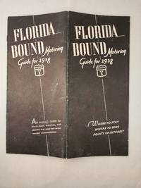
Butler, G. Vincent and Edith Malmgreen Butler with maps by George A Hefferman
Florida Bound Motoring Guide for 1938 By Way of US 1
St Petersburg FL and Newark NJ: G Vincent Butler 1938. 3rd Annual Edition; 8vo.; wraps with stapled binding softcover; 12 pages; black and white illustrations; "An Annual guide for North-South motorists with detailed strip maps and recommended accommodations"; creased down the middle else very good. <br/><br/> St Petersburg, FL and Newark, NJ: G Vincent Butler, 1938 paperback
Referenz des Buchhändlers : 45711
|
|
|
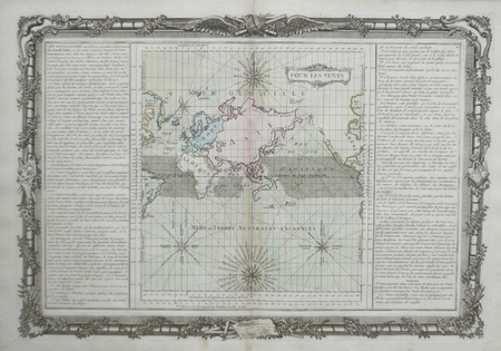
BUY de MORNAS (Claude);
Pour les vents.
Paris Desnos 1761 355 x 520 mm.
Referenz des Buchhändlers : LBW0619a
|
|
|
BUY de MORNAS (Claude);
Pôles du monde, de l'éclyptique, et de l'horison. Points des équinoxes, et des solstices ; points cardinaux, et collatéraux.
[Paris, Desnos, 1761]. 360 x 525 mm.
Referenz des Buchhändlers : LBW061a0

|
|
|
BUY de MORNAS (Claude);
Suite de l'histoire de Carthage depuis l'an 3791 jusqu'à l'an 3860.
Paris Desnos 1761 355 x 523 mm.
Referenz des Buchhändlers : LBW0619c

|
|
|
BUY de MORNAS (Claude);
Suite de l'histoire sainte depuis l'an 3838 jusqu'à l'an 3856.
Paris Desnos 1761 352 x 520 mm.
Referenz des Buchhändlers : LBW0619d

|
|
|
by Alice Taylor ,Color Illustrated by Rafaello Busoni, with Maps Also, DUSTJACKET ONLY, NO BOOK DJ ONLY, Inner DJ Flap $175
Iran by Alice Taylor Illustrated by Rafaello Busoni Dust Jacket Only DUSTJACKET ONLY NO BOOK DJ ONLY A Most Remarkable Nation surviving from Ancient Times
HOLIDAY HOUSE BOOK 1955. VG 1955 DUSTJACKET ONLY NO BOOK DJ ONLY LITE DJ RUB & Wear A Most Remarkable Nation surviving from Ancient Times Persia is now Iran Emerging from Poverty without having Lost any of Her Love of Art Poetry & Fragrant Gardens. Unbound. Illus. by Rafaello Busoni . HOLIDAY HOUSE BOOK paperback
Referenz des Buchhändlers : 28769

|
|
|
BY CECILIA HILL With thirty Four B/W Illustrations & 2 Maps. frontis+ photo illustrations Endpaper maps DJ Flap $2
FIFTY MILES ROUND PARIS BY CECILIA HILL IN 1ST Edition 1927 ULTRA RARE BEIGE & RED DUSTJACKET Journey’s of single Day Planned for visitor who wishes to explore heart of Ancient France Ghostly Castles
HBDJ VG/VG- 1927 on Title pg 1ST edition Hardcover. Condition: Fine-. Dust Jacket Condition: Very Good. SMALL Dark burgundy cloth with Gold gilt Spine Cvr. Hinges & Binding strong. . 12mo 188 pg INDEX o/w VG Copy in dusty but o/w VG DJ with Spine DJ endchips. Hard Cover. FINE-/Very Good. 12mo Ghostly Castles Seat of its 1st Kings St. cloud St. Germaine MalmaisonVersailles Fountainebleau ETC<br /><br /> Robert McBride NY hardcover
Referenz des Buchhändlers : 29334
|
|
|
By Phyllis Eleanor Bentley, Illustrated by Harold Blackburn, Maps are By Macdonald Gill, Striking Cover Design & Endpapers by
Colne Valley Cloth From Earliest Times to Present Day YORKSHIRE ENGLAND An attractively produced history of the local wool and cloth trades in Color Dustjacket of Red & Green Tweeds CLOTH Woolen FABRICS with Typed Letter from Maurice Barber Chairm
HUDDERSFIELD & District Woolen Export Group ENGLAND Printed at Curven Press. LONDON 1947 FRONT INNER BLANK DJ INNER FLAP HAS ORIGINAL PRICE OF 7S.6D.NET At Btm Corner. HBDJ Stated First Published 1947 on Copyright Page 1st Edition VG/GOOD- AS-IS SMALL Chip Front Btm Left of Dustjacket but Does not AFFECT TITLES Other Small Chips Tears Rub Wear Extremities DJ Interior Nice Tight Clean Light Wear Fox DJ Protected Clear Mylar 70 PGS Five maps by Macdonald Gill one folding and in colour. Original cloth woven in a colourful Freedman Salmon & Brown & White Decorated Endpapers Light Fox wear B/W Photographic Frontispiece at Night in Colne Valley of Lighted Factories & Tall Smokestacks with Illustrated B/W Drawings & Color foldout of a Map of Colne Valley Cloth District with 1946 in Corner ILLUSTRATIONS INCLUDE MARKETING CLOTH IN CHURCHYARD Huddersfield Parish Church 1671 Handthrown Shuttle of a 17th Century Loom Seen Thru Press by Sir Francis Meynell Devised & Supervised by William Haigh List of Illustrations in Color Dustjacket of Red & Green Tweeds CLOTH Woolen FABRICS with Typed Letter from Maurice Barber Chairman of Export Group Huddersfield & District Woolen Sub- Group Includes B/W Drawing of Advent of Tweeds Among the Sporting Fraternity Cog Hole Last of Water Driven Scribbling Mills Colour & DesignQuality Tells Wool & Water aps are By Macdonald Gill Covers & Endpapers by Barnett Freedman WEAVING In cludes Color Illustration Another Page from 18TH Century Clothiers Pattern Book. 1st Edition. Hardcover. Very Good/Good. HUDDERSFIELD & District, Woolen Export Group ENGLAND, Printed at Curven Press. LONDON hardcover
Referenz des Buchhändlers : 26905
|
|
|
by Written And Edited By Aeronautical Chamber Of Commerce Of America Inc. Complied (Author), Maps Drawings Photos (Illustrator)
The Aircraft Year Book For 1933: Volume Fifteen Yearbook
D. Van Nostrand Company Inc 1933. Dust jacket has fair amoutnt of edgewear. with small chips and tears and vertical crease to front and back. Boards have slightly darkened spiine with small white blotch there as well. Pages of text are clean lightly age toned and free of markings. Binding is tight and secure. Shipped within 24 hours from the beautiful Baltimore inner harbor area. First class service; accurate descriptions. Most items packed in boxes not envelopes. . Hard Cover. Good/Good. D. Van Nostrand Company, Inc Hardcover
Referenz des Buchhändlers : 233821
|
|
|
Byrd, William.
WILLIAM BYRD'S HISTORIES OF THE DIVIDING LINE BETWIXT VIRGINIA AND NORTH CAROLINA. With Introduction and Notes by William K. Boyd.
pp. 341 + Illus. & Large folding map. Modestly XLib. 8vo. 250 mm. Original full cloth binding. Hardbound. Good. Colonel William Byrd II (1674-1744). From Wikli: He was a planter, slave owner and author from Charles City County in colonial Virginia. He is considered the founder of Richmond, Virginia. Byrd's life showed aspects of both British colonial gentry and an emerging American identity. His education included the classics, apprenticeship with London global business agents, and legal studies. He was admitted to the bar and served for years as Virginia Colony's official agent in London where he opposed increasing the power of royal governors. A member of the Royal Society, he was an early advocate of smallpox inoculation. Upon his return to Virginia, Byrd expanded his plantation holdings, was elected to the House of Burgesses, and served on Virginia Governor's Council, also known as Virginia's Council of State from 1709 until his death in 1744. He commanded county militias and led surveying expeditions along the Virginia-Carolina border and the Northern Neck. This is his 'Secret History' of the 1728 expedition. OVERSIZE 5 / YORK HS
|
|
|
BYRON, KENNETH W & MAYO, JOSEPHINE (Maps)
Lost Treasures in Australia & New Zealand
A H & A W Reed 1965. Super octavo beige cloth boards gilt lettering to spine illus title page 232pp illus/maps VG sl bruising to extrems light tanning & foxing/soiling to page edges & eps sl foxing to prelims & terminals in d/w VG moderate creasing & chipping/tearing to edges light tanning & chafing to spine & covers minor soiling A H & A W Reed 1965 hardcover
Referenz des Buchhändlers : 345280
|
|
|
BYZANCE par Alain DUCELLIER.
Byzance et le monde orthodoxe. Richement documenté (figures, cartes, photos).
Ed. A. Colin 1997. Bel exemplaire broché, gd in-8, 504 pages.
Referenz des Buchhändlers : AUB-6761
|
|
|
BYZANTINE EMPIRE MAP. SPRUNER KARL AND MENKE THEODOR.
Oströmisches Reich 1096-1204
Gotha: Justus Perthes. 1876. Map with original colour and outline hand-colour 32.2 x 40 cm text in German four inset maps central fold slight marginal toning and spotting on the verso but in very good condition. A most handsome and highly detailed map detailing the Eastern provinces of the Byzantine/Roman Empire before the Fourth Crusade. The inset maps depict Constantinople Divisions of the Empire and Antioch issued for the "Hand-Atlas für die Geschichte des Mittelatters und die Neueren Zeit" . Justus Perthes unknown
Referenz des Buchhändlers : 174911
|
|
|
BYZANTINE EMPIRE MAP. SPRUNER KARL AND MENKE THEODOR.
Oströmisches Reich zu Justinians Zeit.
Gotha.: Justus Perthes. Map with original colour and outline hand-colour 32.2 x 40 cm text in German five inset maps central fold slight marginal toning and spotting on the verso but in very good condition. A most handsome and highly detailed map detailing the Eastern provinces of the Byzantine/Roman Empire in the time of the Roman Emperor Justinian 527-565. The inset maps depict Carthage Rome Constantinople Naples and a Western continuation of the main map originally issued for the "Hand-Atlas für die Geschichte des Mittelatters und die Neueren Zeit" . Justus Perthes. unknown
Referenz des Buchhändlers : 174950
|
|
|
BÆDEKER Karl:
Londres et ses environs. Manuel du voyageur.
Leipzig & Paris, Karl Bædeker et Librairie Ollendorff, 1913. In-8 de [2]-XXXVIII-408-[2] p., pleine percaline rouge ornée de filets à froid, titre doré, tranches marbrées, signet. Dos légèrement passé, une charnière fendue.
Referenz des Buchhändlers : 6475
|
|
|
BÆDEKER Karl:
Londres et ses environs. Manuel du voyageur.
Leipzig & Paris, Karl Bædeker et Librairie Ollendorff, 1913. In-8 de [2]-XXXVIII-408-[2] p., pleine percaline rouge ornée de filets à froid, titre doré, tranches marbrées, 2 signets, jaquette conservée quoiqu'avec quelques manques. La jaquette mise à part, en parfait état.
Referenz des Buchhändlers : 6478

|
|
|
BÉRARD (Auguste).
[TUNISIE] Plan particulier de l'île de La Galite.
[Paris], Dépôt-Général de la Marine, 1834. 432 x 590 mm.
Referenz des Buchhändlers : LBW-8665

|
|
|
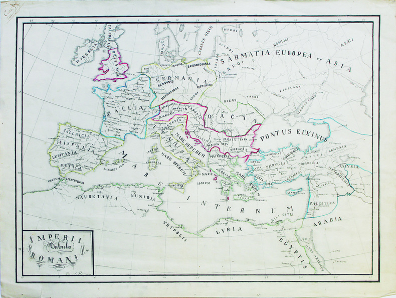
BÉRINGER (A.).
Imperii Romani tabula.
[vers 1830]. 37 x 49 cm, sur une feuille de 41,5 x 54,6 cm.
Referenz des Buchhändlers : LBW-6614
|
|
|
BÉRENGIER (Théophile)
La Nouvelle-Nursie. Histoire d'une colonie bénédictine dans l'Australie occidentale (1846-1848).
Paris, Jacques Lecoffre, 1879, in-8 (24,5x16cm), portrait frontispice de Mons. Salvado, 3ff.-VIII-387 pp.-1f., brochage éditeur, illustré de 36 planches gravées sur bois, défaut au titre, rousseurs, décoloration à la carte.
Referenz des Buchhändlers : PHO-1987

|
|
|
C SAUVAGE - A BUVIGNIER
Statistique minéralogique et géologique du département des Ardennes Mézières, Trécourt, imprimeur 1842
in8 reliure dos toilé à pièce de titre papier, plats marbrés, 5 planches nb et couleurs dépliantes in fine
Referenz des Buchhändlers : 2cb1

|
|
|
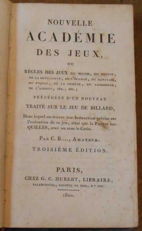
C... B... Amateur ( Charles Bouvard)
Nouvelle Académie des Jeux ou Règles des Jeux du Whist du Boston de la Bouillotte de l 'Ecarté du Reversis du piquet de la Comète du Commerce de l'Ambigu etc... etc... ; précédées d'un Nouveau Traité sur le Jeu du Billard Dans lequel on trouve une Instruction précise sur l'exécution de ce jeu ainsi que la Partie des Quilles avec ou sans le Casin
1822. Paris chez G. C. Hubert 1822 3ème édition - Relié 10 5 cm x 18 cm 292 pages - Texte de C... B... Amateur ( Charles Bouvard) - Epissures sur le dos sinon bon état ; 60 pages consacrées au billard
Referenz des Buchhändlers : 17663
|
|
|
CABRE Monique SEBBAG Marina VIDAL Vincent
FEMMES DE PAPIER
milan , jaquette , état neuf , 174 p , 1998 , trés trés riche iconographie en couleur
Referenz des Buchhändlers : 1651
|
|
|
CABOURET, Bernadette (Coordination)
Questions d'histoire. L'Afrique romaine de 69 à 439. Romanisation et Christianisation
2005 - broché - Editions du Temps - Collection "Histoire ancienne" - 2005 - In-8 (24 x 16 cm) broché - 345 pages + quelques cartes in fine - ISBN : 9782842743260 - Ouvrage collectif coordonné par Bernadette CABOURET
Referenz des Buchhändlers : 387

|
|
|
CACAULT (François) & LE ROUGE (Georges-Louis).
[NANTES] Plan de Nantes, avec les changements et augmentations qu'on y a fait depuis 1757.
Paris, Le Rouge, 1766. 563 x 477 mm.
Referenz des Buchhändlers : LBW-6790
|
|
|
CADIX -
Plan de la Ville de Cadix. Sa Baie, et ses Environs. Rédigé d'apres une Carte trés exacte et particulière
Milano, Chez Bettalli, (ca. 1810). (56 x 84 cm.). Large engraved plan of Cadix and surroundings, sectioned in 8 and mounted on linen. Handcoloured. Gravé en Milan par Louis Rados. Some faint scattered brownspots.
Referenz des Buchhändlers : 56906
|
|
|
CADIX -
Plan de la Ville de Cadix. Sa Baie, et ses Environs. Rédigé d'apres une Carte trés exacte et particulière
Milano, Chez Bettalli, (ca. 1810). (56 x 84 cm.). Large engraved plan of Cadix and surroundings, sectioned in 8 and mounted on linen. Handcoloured. Gravé en Milan par Louis Rados. Some faint scattered brownspots.
|
|
|
CAEN
Carte couleurs au 1/100 000?. Feuille XI-12.
Une feuille 57x45 cm.
|
|
|
CAEN
Plan guide. R?pertoire des rues, renseignements divers.
Une feuille repli?e.
|
|
|
CAFFI Ippolito (Belluno 1809 – Lissa 1866)
Panorama di Roma veduta dalla Torre del Campidoglio
Litografia, 1839, firmata e datata in basso a destra e sinistra. Bellissima prova, impressa su quattro fogli di carta coeva uniti, leggere ossidazioni, per il resto in ottimo stato di conservazione. Questo panorama è idealmente preso dalla torre del Campidoglio ruotando da sinistra verso destra di 360 gradi, con una raffigurazione che inizia dal Pincio e si chiude a Piazza del Popolo. L’opera è stampata dalla litografia Kier di Venezia e nel margine inferiore reca una leggenda di 69 numeri. L’impianto della veduta è ancora quello di un pittore di tradizione settecentesca, in sintonia con la definizione che lo stesso Caffi, allora trentenne, dava di se stesso: “pittore prospettico”. Emilio Re nella biografia sull’artista della mostra romana del 1959 definisce, già allora, “rara” la veduta. Bibliografia: Vedute Romane, pp. 13, 50, n. 74; Roma Veduta, p. 221, 67; Le piante di Roma nelle collezioni private, p. 344, 276. Lithograph, 1839, signed and dated on lower right and left. Beautiful work, printed on four sheets of contemporary paper - joined together - light oxidations otherwise in excellent condition. This panorama is ideally seen from the tower of the Campidoglio, rotating towards the right side of 360 degrees, starting from the Pincio and ending in Piazza del Popolo. The work has been printed by the Kier lithography in Venice; on lower margin it bears 69 numbers. The setting of the view recalls that of an XVIII century painter, according to the definition that Caffi himself, at the age of thirty, gave of his art: “perspective painter”. In his biography of the artist, written on the occasion of the 1959 exhibition, Emilio Re defined this subject “rare”. Bibliografia: Vedute Romane, pp. 13, 50, n. 74; Roma Veduta, p. 221, 67; Le piante di Roma nelle collezioni private, p. 344, 276. Dimensioni 1450x145. Vedute Romane, pp. 13, 50, n. 74; M. Gori Sassoli (a cura di), "Roma Veduta", p. 221, s. 67; C. Marigliani, "Le Piante di Roma delle collezioni private", tav. 276.

|
|
|
CAGNAT Lieutenant
Journal des Marches et des combats du régiment d’Anjou
Infanterie au cours de la guerre de succession d’Autriche 1741-1748 extrait du spectateur militaire. etit in 8 broché,titre au dos, en long et sur le premier plat,94 pages,1 page de bibliographie,cartes,plans;dans le texte.Henri Charles Lavauzelle éditeur sans date.Rousseurs sur la couverture avec un manque angle supérieur droit. du premier plat.Peu courant
Referenz des Buchhändlers : 7982
|
|
|
Cahiers du centenaire de l'Algérie - Cartes du Commandant POLLACCHI - Pierre DELONCLE & Paul CROUSSET
CARTES-INDEX - Glosaire, Documents annexes, Rapport général
Publication du Comité National Métropolitain du Centenaire de l'Algérie - Vers 1930 - 71 pages, dont glossaire des noms cités & 5 grandes cates dépliantes de l'Afrique du Nord, dont une indiquant les progrès de la Pacification Française - Très propre - Rare
Referenz des Buchhändlers : 5074
|
|
|
CAHIERS DU CENTENAIRE DE L'ALGERIE
12- : Cartes - Index - Glossaire - Documents annexes - Rapport g?n?ral. 6 cartes d?pliantes.
Broch?. 72 pages.
|
|
|
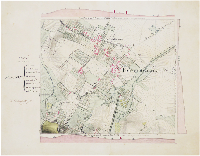
CAIZAC et al.
[YVELINES] Carte minute de Fontenay-le-Fleury.
1825. 32,5 x 41 cm.
Referenz des Buchhändlers : LBW-7430
|
|
|
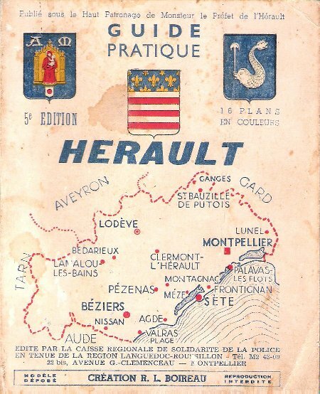
Caisse Régionale De Solidarité de La Police En Tenue De La Région Languedoc-Roussillon
Guide Pratique HERAULT
Montpellier BOIREAU 1952 In 12 , carré Si la couverture est quelque peu marquée par les usages , l'intérieur est très bon et comporte de nombreuses cartes en couleurs avec les quartiers de Montpellier , ainsi que des dépliants du département et de la signalisation . Tous les commerçants de l'époque . Cartes et plans .- 412 p. + Cartes , 400 gr.
Referenz des Buchhändlers : 022441
|
|
|
Caisse Régionale De Solidarité de La Police En Tenue De La Région Languedoc-Roussillon
Guide Pratique HERAULT
Si la couverture est quelque peu marquée par les usages , l'intérieur est très bon et comporte de nombreuses cartes en couleurs avec les quartiers de Montpellier , ainsi que des dépliants du département et de la signalisation . Tous les commerçants de l'époque . Cartes et plans .- 412 p. + Cartes , 400 gr.

|
|
|
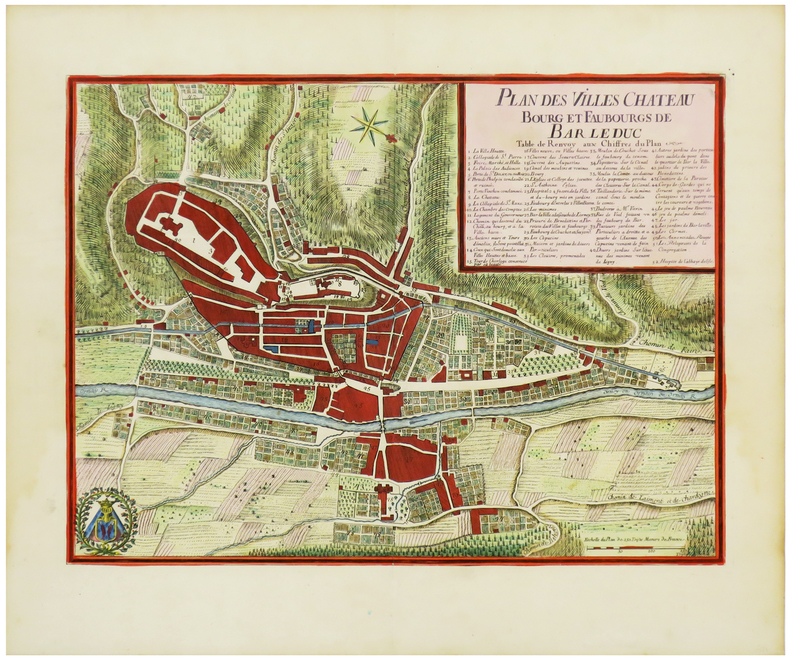
CALMET (Augustin).
[BAR-LE-DUC] Plan des villes château bourg et faubourgs de Bar Le Duc.
[Nancy, 1728]. 294 x 391 mm.
Referenz des Buchhändlers : LBW-6299
|
|
|
CALAIS. MANUSCRIT.
[Plan de Calais].
[circa 1760]. En deux feuilles jointes de 307 x 518 mm.
Referenz des Buchhändlers : LBW-466

|
|
 Per e-mail erhalten
 Als pdf-Dokument herunterladen
 RSS feed


