|
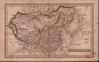
EARLY 19TH CENTURY MAP OF CHINA.
Chinese Empire.
London.: Robert Jennings. c1828. Engraved map with original hand colouring 24x 14cm vertical fold foxed and browned. Still a delightful little map. From Fenner's "Pocket Atlas of Modern & Ancient Geography" c1828. Has interesting descriptions including; Great Sandy Desert of Cobi sic called by the Chinese 'Shamo'; "Small island seen by Capt. Moore;" 'Fatsisio' place of exile for the Japanese. . (Robert Jennings) unknown
Bookseller reference : 214901
|
|
|
Early Printed Maps of Canada Vol. III 1703-1799
Early Printed Maps of Canada
Kershaw Pub 1997. First Edition. Hardcover. very Good/Very Good. 0x0x0. this copy has a solid tight binding with clean u unmarked pages light bit of edge wear to the dj from the shelf.Maps of Eastern Canada & Newfoundland The Maritimes Nova Scotia Halifax Prince Edward Island Sable Island Cape Breton Louisbourg & The Great Lakes. Kershaw Pub hardcover
Bookseller reference : js5667 ISBN : 096971842X 9780969718420
|
|
|
Easterbrook, Don J.
Landforms of Washington: The Geologic Environment
Book shows light shelf wear to covers Binding is solid and square, covers have sharp corners, exterior shows no blemishes, text/interior is clean and free of marking of any kind. Written as an illustrated account of the nature and effects of geology and the topography of Washington State, the effects of glaciation, flooding, and material composition. Includes two maps of the geology of Washington State with a pamphlet "6 times in 3,500 years," about the Kautz Creek Mudflow Nature Trail (1975) regarding the eruption of Mt. Rainier. Contents include: Cascade mountains, Puget lowland, Coast ranges, Columbia basin , Northern rocky mountains. 156 pages
|
|
|
Easyfind Series of Maps
Map and Street Directory of Durham
Worcester: Littlebury & Company Limited .please e-mail for further details. Not Signed or Inscribed. This is a First Edition. Red Card. Very Good AVERAGE/No Jacket. Illus. by Ilustrated with Large Fold Out Map. 12mo - over 6¾" - 7¾". PAPERBACK. Littlebury & Company Limited Paperback
Bookseller reference : 008272
|
|
|
EBERLIN Philippe:
Rapport de mer. Navires et marins au service de la Suisse et de la Croix-Rouge pendant la guerre de 1939-1945.
Berne, Office central fédéraldes imprimés et du matériel, 1970. In-8 broché de 285 pages, couverture illustrée.
Bookseller reference : 19980

|
|
|
EBUL'ULA MARDIN, (Turkish jurist, academician and politician), (1881-1957).
Huzur dersleri. 2 volumes set.
Very Good Turkish In decorative contemporary clothes. Roy. 8vo. (24 x 17 cm). In Turkish. 2 volumes set: (614 p.;1154 p.). Mardin was a Turkish jurist, academician and politician. He was one of the ends of the Ottoman Empire and the firsts of Turkish Republic lawyers. He worked as a lecturer at Istanbul University during his whole life, where he graduated, and became a professor of the Civil Law. He ws born in Shkodra. Scarce. First Edition.
|
|
|
Eby, Ezra E. (1895-96), Joseph B. Snyder (1931); Eldon D. Weber (index, notes, maps and documents)
A Biographical History of Early Settlers and Their Descendants in Waterloo Township
Waterloo Canada: Eldon D. Weber 1984. hardcover. Good. 0x0x0. Fair brown cloth hardcover has fraying to spine ends and edges and 3x2" and a 1x2" pieces if cloth missing from the spine exposing the cardboard underneath gift inscription on front endpage binding sound internally clean. copyright page has the address for Eldon Weber crossed out and a new address stamped below it. Includes an index and a map enclosed in an envelope affixed to the rear inside cover. Includes a supplement by Joseph B. Snyder. 1984 reprint ISBN 0919061001. Not a print on demand copy. Around 1800 families of Mennonites began to move north from the United States to Canada in search of farm land. Ezra Eby collected family histories from Pennsylvania German pioneer families in Waterloo Township Ontario and originally published these as "A Biographical History of Waterloo Township" in 1895 and 1896. Eldon D. Weber hardcover
Bookseller reference : 250713001 ISBN : 0919061001 9780919061002
|
|
|
Eby, Ezra E. (1895-96), Joseph B. Snyder (1931); Eldon D. Weber (index, notes, maps and documents)
A Biographical History of Early Settlers and Their Descendants in Waterloo Township with A Supplement
Eldon D. Weber 1984. Book. Near Fine. Hardcover. First Thus. 4to - over 9¾" - 12" tall. Brown leatherette lettered in gold foil. 3rd ptg. 1984 of facsimile reprint edition. Slightly soiled covers nearly as issued. Main text dates to 1895-96 Eby with 1931 supplement by Snyder every-name index and geographical index by Weber. Map in rear pocket as called for. Eldon D. Weber Hardcover
Bookseller reference : 057032 ISBN : 0919061001 9780919061002
|
|
|
ECOMMOY
Carte couleurs topographique au 1/25 000e d'Ecommoy. Partie ouest.
Une feuille 77x90 cm.
|
|
|
ECOSSE. . .
The tourist's atlas guide to Scotland. 32 pages of coloured maps. . . 24 pages of gazetteer. . . Sans date.
Broch?. 64 pages. Couverture l?g?rement d?fra?chie.
|
|
|
ed C. C. J. Bond Maps W. R. Feasby
Official History of the Canadian Medical Services 1939 - 1945 2 Volume Set Vol. I: Organization and Campaigns. Vol. II: Clinical Subjects.
Ottawa: Edmond Cloutier Queens' Printer and Controller of Stationery. Very Good in Very Good- dust jacket. 1956. First Edition. Hardcover. Volume I has no dust jacket the red coth covered boards dated 1956 some shelf soil to page edges top back corner bumped. Volume II dated 1953 has chipped DJ 1 inch tear bottom front panel and 2 inch tear top back panel. ; Fold-out maps in Vol. I and map endpapers appear undamaged B&W and color illustrations in Vol II ; Color Illustrations . Edmond Cloutier, Queens' Printer and Controller of Stationery hardcover
Bookseller reference : 15240

|
|
|
EDELSON, E.
Sachez prédire votre avenir.
in-12 carré, 167 pp., illustrations et fig., broché, couv. illustree. Tres bel exemplaire, très frais. [CA30-5][NV-28][BL-11][MI-19] Dés, rêves, I ching, cartes, tarots, nombres, dominos, boule de cristal, feuilles de thé, lignes de la main.
|
|
|
Eden-Roc Cap d'Antibes
Souvenir du pavillon Eden-Roc Cap d'Antibes album de 10 cartes postales
LEVY sd - album de 10 cartes postales sous serpentes et une carte,bon état
Bookseller reference : 27008

|
|
|
EDER Joseph
Prospect der Stadt Rom
Raffigurazione della città con deformazione verticale dei monumenti, panorama della città da Monte Mario. Incisa da A. Sommer e stampata a Vienna intorno al 1770. (Marigliani indica erronemente la data di stampa in 1730). La veduta prospettica (incisione su rame) rappresenta Roma secondo il modulo inaugurato dai disegnatori tedeschi nella prima metà del sec. XVIII. Editore e autore del disegno sono, rispettivamente, i poco documentati J. Eder e A. Sommer, le cui firme compaiono agli angoli sotto il margine inferiore.Poche notizie si hanno a riguardo dell’editore Joseph Eder, nativo di Vienna. Sommer potrebbe essere lo pseudonimo di Alois Sonne von Sonnefeld, incisore sempre originario della capitale austriaca. Incisione in rame, in ottimo stato di conservazione. Rara. Raffigurazione della città con deformazione verticale dei monumenti, panorama della città da Monte Mario. Incisa da A. Sommer e stampata a Vienna intorno al 1770. (Marigliani indica erronemente la data di stampa in 1730). La veduta prospettica (incisione su rame) rappresenta Roma secondo il modulo inaugurato dai disegnatori tedeschi nella prima metà del sec. XVIII. Editore e autore del disegno sono, rispettivamente, i poco documentati J. Eder e A. Sommer, le cui firme compaiono agli angoli sotto il margine inferiore.Poche notizie si hanno a riguardo dell’editore Joseph Eder, nativo di Vienna. Sommer potrebbe essere lo pseudonimo di Alois Sonne von Sonnefeld, incisore sempre originario della capitale austriaca. Incisione in rame, in ottimo stato di conservazione. Rara. C. Marigliani, "Le Piante di Roma delle collezioni private", tav. 184

|
|
|
Edgar McInnis and Maps and Photos
War Fourth Year
Hardcover. Very Good. Visually inspected by Bonnie: hardback copyright 1945 no marking text good condition on pages book cover and binding shelf wear. #A; We ship M-F by 4pm MDT and Saturday by 12pm with tracking info. hardcover
Bookseller reference : W5-JIVL-VHCI
|
|
|
Edited by Hideki Ozaki et al., Meiji Maps
100 year history of children's books
Not Available 1973. Soft Cover. Fine. The book is in fine condition. Not Available paperback
Bookseller reference : 2080502106904303
|
|
|
Edited by Yoshihiro Saito Meiji Maps
A Female Teacher at a Shima Elementary School That Has Changed Me
Not Available 1967. Soft Cover. Fine. The book is in fine condition. Not Available paperback
Bookseller reference : 2090502113703439
|
|
|
Edited by the Editing Committee of Mechanical Engineering Maps
Automobiles Railway vehicles
Giho-sha 1955. Soft Cover. Fine. Volume: 1 Giho-sha paperback
Bookseller reference : 2083002117401981
|
|
|
Edited by the Society of Old Maps of Japan
Kochi-zu Kenkyu Vol. 301-314 Vol. 307 missing 13 vols.
Not Available 1995. Soft Cover. Fine. Volume: 13 Not Available paperback
Bookseller reference : 2091502135417324
|
|
|
Edited by Saikyo Takehiko / Meiji Maps
Literature class Elementary school 2nd grade
Not Available 1975. Soft Cover. Fine. The book is in fine condition. Not Available paperback
Bookseller reference : 2090502113715761
|
|
|
Edited by Saikyo Takehiko / Meiji Maps
Literature class Elementary school 6th grade
Not Available 1978. Soft Cover. Fine. The book is in fine condition. Not Available paperback
Bookseller reference : 2090502113712102
|
|
|
Edited by Saikyo Takehiko / Meiji Maps
Literature class 5th grade elementary school
Not Available 1978. Soft Cover. Fine. The book is in fine condition. Not Available paperback
Bookseller reference : 2090502113712103
|
|
|
Edited by the Japanese Language Education Society of Japan, Meiji Maps
Reform of Japanese language education Complete set of three volumes
Not Available 1968. Soft Cover. Fine. The book is in fine condition. Not Available paperback
Bookseller reference : 2080502106913718
|
|
|
Edited by Tadatoshi Okubo and Kisao Kobayashi Meiji Maps
teacher speaking skills
Not Available 1979. Soft Cover. Fine. The book is in fine condition. Not Available paperback
Bookseller reference : 2090502113708698
|
|
|
Edited by . A. Plummer. With maps notes and introduction
The Cambridge Bible for Schools and Colleges. The Gospel According to St. Mark
Cambridge University Press 1920 Cambridge University Press 1920 hardback no jacket blue titles to mottled blue boards xlviii 211 pp with colour maps at rear slight discolouring to spine Otherwise in VERY GOOD CLEAN TIGHT READING ORDER. Full refund if not satisfied. 24 hour dispatch. If not pictured in this listing a scan of the actual book is available on request. Hardcover. Very Good. Cambridge University Press hardcover
Bookseller reference : toi155
|
|
|
Edited by Edward John Payne. With Additional Notes, Maps, Etc., By
Voyages of Drake and Gilbert. Select Narratives from the "Principal navigations" of Hakluyt
Oxford: Oxford at the Clarendon Press 1925. Cloth Bound Boards. Very Good/No Jacket. 12mo - over 6¾" - 7¾" tall. Size 7½" x 4¾" 327 pages. Green cloth covered boards with black stamped titles in an ornate art deco frame on the front cover and spine. Condition very good owners inscription on front endpaper cover a bit grubby bottom right edge of front cover a bit tatty contents clean complete intact. With full page maps of North America and South America. <br/> <br/> Oxford at the Clarendon Press hardcover
Bookseller reference : 010445
|
|
|
Edited by Payne, EJ with additional notes, maps, etc., by Beazley C. Raymond
VOYAGES OF HAWKINS FROBISHER AND DRAKE: Select Narratives from the "Principal Navigations" of Hakluyt
Clarendon Press 1922. Cloth. Good. 1922 Edition; lvi 280pp. Green cloth covers with black decoration and titling. previous owners signature on fep shelfware contents clean. Good Quantity Available: 1. Shipped Weight: Under 1 kilogram. Category: Exploration; Antarctic; Pictures of this item not already displayed here available upon request. Inventory No: 2673. . Clarendon Press hardcover
Bookseller reference : 2673

|
|
|
Edited by Yasuji Okumura Meiji Maps
When the flowers open Record of an adolescent girl Meiji Zusho Junior High School Bunko 28
Not Available 1980. Soft Cover. Fine. The book is in fine condition. Not Available paperback
Bookseller reference : 2090502113716153
|
|
|
Edited by FATIH DALGALI.
Sultan II. Abdülhamid devri harita ve planlarinda Istanbul.
New English Original cloth bdg. Folio. (41 x 31 cm). In Turkish. 328 p., color ills. and maps. Istanbul, Constantinople in the maps and drawings of Sultan Abdulhamid II's epoch. A very heavy volume. Extra shipping cost will be requested. Sultan II. Abdülhamid devri harita ve planlarinda Istanbul.
|
|
|
Edited by IRFAN DAGDELEN.
Charles Edouard Goad'in Istanbul sigorta haritalari.
New Turkish Original bdg. HC. Folio. (42 x 34 cm). Text in Turkish and French. [xx], [66], 37, [1] p., color maps. Charles Edouard Goad'in Istanbul sigorta haritalari. Fire insurance maps of Istanbul by Charles Edouard Goad, (1848-1910). He was a cartographer and civil engineer, was born on 15 March 1848 at High Street, Camberwell, Surrey, the second son of Charles Goad, plumber, of London, and his wife, Caroline Ann (née Vogel). 1000 copies were printed.
|
|
|
Edited by KAROLY KOCSIS, FERENC SCHWEITZER.
Hungary in maps.
New English Original bdg. HC. 4to. (30 x 21 cm). In English. 211 p., fully color maps and tables. Hungary in maps. Main contents: Foreword.; Hungary in the world.; Characteristics of historical evolution.; Natural environment.; Population and settlement.; Economy.; References.; List of figures.; List of tables.
|
|
|
Edited by TADEUSZ MAJDA.
Masterpieces of Persian art from Polish Collections. Vol. 1: lllustrations. Vol. 2: Essays and descriptive catalogue.= Sâhkârîhâ-ye honar-e Îrân dar majmû'eh'hâ-ye Lahestân. Jild-i 1: Tasâwir. Jild-i 2: Maqâlât wa sarh-e tafsili-je tasâwir. 2 volumes set.
New New English Original bdg. Dust wrapper. In publisher's special slip-case. Folio. (32 x 24 cm). In English and Persian. 2 volumes set: (419 p.; 132, 123 p., many numerous color plates with full pages). Masterpieces of Persian Art from Polish Collections. Vol. 1: lllustrations. Vol. 2: Essays and descriptive catalogue.= Sâhkârîhâ-ye honar-e Îrân dar majmû'eh'hâ-ye Lahestân. Jild-i 1: Tasâwir. Jild-i 2: Maqâlât wa sarh-e tafsili-je tasâwir. 2 volumes set. This book is an enlarged version of the catalogue titled 'Masterpieces of Persian art from Polish collections' of the exhibition held at the National Museum in Warsaw and at the National Museum in Cracow in 2002.
|
|
|
EDITED ERNEST RHYS ,DECORATED ENDPAPERS FORMER OWNER NAME, INCLUDES NUMEROUS MAPS IN COLOR WITH INDEX, GAZETTEER, ETC
A LITERARY & HISTORICAL ATLAS OF ASIA EVERYMAN’S LIBRAry #633 STATED 1ST PUBLISHED THIS EDITION 1912 in Purple dj with design in b/w on Front INCLUDES NUMEROUS MAPS IN COLOR WITH INDEX GAZETTEER OF TOWN & PLACES ETC REFERENCE 4TH IN SERIES OF SPECIAL ATLASES DESIGNED FOR EL
<p>HBDJ STATED 1ST PUBLISHED THIS EDITION 1912 SMALL PURPLE EMBOSSED CLOTH CVRLITE RUB WEAR VG/VG AS-IS BACK OF DJ MENTIONS OVER 960 VOLUMES ENDS WITH ZOLA 226 PGS INDEX LIST OF TITLES OUTER SPINE CVR HAS SMALL NICK DEALS WITH COUNTRIES OF ASIA WHOSE HISTORY & GEOGRAPHY ARE ALIKE RELECTED IN MAPS. & CHARTS THAT FOLLOW Philipine Islands JAVA EAST INDIES AUSTRALIA MADRAS CEYLON SIBERIA KOREA MANCHURIA JAPAN SINGAPORE FAR EAST ETC</p> J. M.DENT EVERYMAN’S LIBRARY LONDON hardcover
Bookseller reference : 30210
|
|
|
Edition Beringer & Pampaluchi, Zurich 27
Lotto di 2 cartoline - Cartes Postales - Chateau de Chillon. Musée + La Chapelle
2 Cartoline postali non viaggiate, senza data. Codice W 8254 + W 4154 - Vedi foto fronte e retro. 2 Unused and undated post cards in good condition, 141 x 90 mm - Worldwide delivery.

|
|
|
Editor, Sir Mortimer Wheeler and Illustrated throughout with black and white maps
Swans Hellenic Cruises 1971 Handbook
Jan 01 1970. Hardcover. Good. Sold by the Charity Kisharon Langdon Supporting young people with disabilities hardcover
Bookseller reference : HistoryBox33/GRAHAM1103/2
|
|
|
Editore Mauro Gigli
Pianta Panoramica Di Roma - Con Circa 500 Monumenti (Panoramic Map of Rome with 500 Monuments indicated)
Attractive 39.25" x 29" panoramic color map of Rome. Back side includes street map and list of principal buildings. Text in Italian. Undated, circa 1960? Stored in 8" x 5.5" yellow and red illustrated card cover. Moderate wear. A lovely memento of Rome. Map

|
|
|
EDITORIAL UNIT OF WAR DISPATCHES OF MAP WORKERS' REPRESENTATIVE ASSEMBLY OF CHINA CARTOGRAPHIC PUBLISHING HOUSE REVOLUTIONARY C
地图戰報: 第6期. Di tu zhan bao: di liu qi. Chinese Cultural Revolution Maps - War Dispatches of Maps. Issue no. 6.
Beijing.: 地图戰報.Di tu zhan bao. September1967. Maps printed in red and black single sheet printed on both sides folded scale not given photographic image of Mao Zedong. Some light browning at edges with tears and losses on left edge still good. Text in Chinese. Sheet measures 26.5 x 38.4cm. Includes a map of Autumn Harvest Uprising and also shows the routes of the military advancing towards Jinggangshan between September and October 1927. On reverse left section a map shows the route along which Chairman Mao led the Fourth Army of the Chinese Red Army marching towards south of Anhui and Jiangxi Provinces in 1929. On reverse right section a map titled "The Long March of The Chinese Workers' and Peasants' Red Army October 1934-October 1935". Quotations of Chairman Mao about the Long March insert on corners of the map. <br> <br>Issue no. 6 of a series of maps with text issued by the Red Guards organisations in the form of Cultural Revolution tabloid-sized newspaper. This issue is designed to celebrate the 40th anniversary of the Autumn Harvest Uprising which was one of the earliest armed uprisings organised by the Chinese Communist Party. . 地图戰報.[Di tu zhan bao]. unknown
Bookseller reference : 169746

|
|
|
editors of Meds Maps
Nantucket A pictorial guide
Meds Maps no date 1/1/1998 12:00:00 AM. paperback. New. in x in x in. NULL Meds Maps, no date paperback
Bookseller reference : mon0000029047 ISBN : 1890463248 9781890463243
|
|
|
Edmonds James E. Maps & Sketches By A. F. Becke
Military Operations France and Belgium 1918: The German March Offensive and Its Preliminaries v. 1 Official History of the Great War
hardcover. Good. Access codes and supplements are not guaranteed with used items. May be an ex-library book. hardcover
Bookseller reference : 1870423933.G ISBN : 1870423933 9781870423939
|
|
|
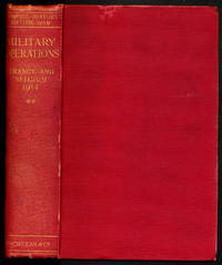
Edmonds, Brigadier-General Sir James E., compiled by. Maps and sketches compiled by Major A. F. Becke
MILITARY OPERATIONS FRANCE AND BELGIUM 1914. Volume 2. Antwerp La Bassee Armentieres Messines and Ypres October- November 1914
<p>London: Macmillan and Co. Limited 1929. 1929 reprint. hardcover. Very Good. Octavo red cloth covers xxvii 9 548 4 pages of ads for the series. Maps on endpapers and maps in the text. Corrections tipped in on several pages some red ink cross-outs text still readable. A few spots on covers and minor color bleeding into top margin of front map--does not affect image. Does not include separate map case. Part of the series: History of the Great War Based on Official Documents by Direction of the Historical Section of the Committee of Imperial Defense. 040414A</p> Macmillan and Co., Limited hardcover
Bookseller reference : 000015669
|
|
|
Edmonds, James E. (Maps & Skstches Compiled By Becke, A. F.)
Military Operations France And Belgium 1916
Nashville: Battery Press 1993. Book. Near Fine. Hardcover. A very nice copy. Front cover board slightly warped. . Battery Press Hardcover
Bookseller reference : 507741 ISBN : 0898391857 9780898391855
|
|
|
Edmonds, James E. (Maps & Skstches Compiled By Becke, A. F.)
Military Operations France And Belgium 1916
Battery Press 1993. Hardcover. New. 0x0x0. Brand New Book Battery Press hardcover
Bookseller reference : 61593 ISBN : 0898391857 9780898391855
|
|
|
Edward Pierrepont; Leonard Forbes Beckwith (maps)
Fifth Avenue to Alaska
New York: G. P. Putnam's Sons1884. First edition. Hardcover book bound in the publisher's original full decorative cloth-gilt. 20.5 cm. 329 pp. Contains four folding maps by Leonard Forbes Beckwith. In near fine condition. No ownership marks/writing present within. Hinges tight pages bright. Light edge wear to the cloth covers. unknown
Bookseller reference : 194

|
|
|
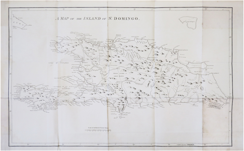
EDWARDS (Bryan).
[SAINT-DOMINGUE] A map of the island of S.t Domingo.
[Londres, 1818]. 455 x 740 mm.
Bookseller reference : LBW-7906
|
|
|
EDWARDS, Bryan
The History, Civil and Commercial, of the British Colonies in the West Indies
8vo [22 x 15 cm]; 3 volumes, xxiv, xxiii, 576; viii, 618; xxii, 477 pp, 22 engraved maps and plates, many folding, including frontis portrait and 11 maps. later half calf, gilt title lettering on spines, edges worn, signature, a map split at fold, only light foxing, very good set. A picture of this book is available upon request by email. Sabin 21901. Cundall 2095. Welch 264. The maps include west Indies, Jamaica, Barbados, Granada, St. Vincent, Dominica, St. Christopher and Nevis, Antiqua, Virgin Islands, St. Doningo, Tobago. The plates include Negro festival, plan for sugar mill, view of Trelawney town, aboriginal peoples, bread fruit, etc. The first edition was 1793 in two volumes. The earlier editions had only 5 maps, few plates. Regatz 165: 'A classic in British Caribbean literature and probably the most famous work in the field. Standard for over a century, and still in many respects the best book on the subject up to the close of the 18th century'.
|
|
|
Edwin Emerson, Jr. & Marion Mills Miller, Illustratec With Plates, Engraving And Maps
A.D. 1800 to the Present Time 3 Volumes
N.Y. : New York: P.F. Collier & Son Publishers 1906. Good/Good. Hard Cover. Good/Good. 8vo-over 7¾"-9¾" tall. Vol. 1-from 1800-1821 spine cracked on inside of back and front cover small wear to top of spine. Vol. 2-from 1822-1860 spine cracked book tight Vol. 3-from 1861-1906 spine very cracked-loose wear to outerspine and corners of book. Books are very old yellow/brownish pages. but all books intact except Vol.3 three loose spine. <br/> <br/> N.Y. : New York: P.F. Collier & Son, Publishers, 1906 hardcover
Bookseller reference : 000268
|
|
|
Efrat, Elisha ; Gavriely, Ehud
Settlement Sites in Israel [IN HEBREW].
IN HEBREW. CONTAINS MAPS AND PLATES. 270x215 mm. XXXI+168 pages. Softcover. Cover rubbed and slightly stained. Cover corners slightly wrinkled. Cover edges slightly worn. Spine yellowing and stained. Spine corners and edges worn. Pages slightly yellowing. Else in good condition.
|
|
|
Eggleston, Wilfred
The Queen's Choice - A Story of Canada's Capital
325 pages including, index, archival black and white photographic plates and several fold-out maps. An excellent history of Canada's national capital. Average wear. Some soiling to bottom edge. Prior owner's name atop front endpaper. Book
|
|
|
EGLI LEGEAR, Clara:
LIST OF GEOGRAPHICAL ATLASES IN THE LIBRARY OF CONGRESS, Volume 7 + volume 8 (= Index to Vol. 7) (titles 10255-18435). 2 vols together.
Washington, Library of Congress, 1973, 1974, lg. in-8vo, CXXX (130 p.) + 1 ll. + 708 p. / 190 p., original clothbound
Bookseller reference : 91200aaf
|
|
|
EGLI LEGEAR, Clara:
LIST OF GEOGRAPHICAL ATLASES IN THE LIBRARY OF CONGRESS, Volume 6 Titles 7624-10254.
Washington, Library of Congress, 1958 lg. in-8vo, LXXII (72 p.) +1 ll. + 681 p., original clothbound
Bookseller reference : 91202aaf
|
|
 Receive by email
 Download as PDF document
 RSS feed


