|
HERALD Georges W. et Edward D. RADIN
MONTE-CARLO : un siècle de roulette.
broché - 15,5x21,5 - 267 pp - 1964 - éditions de trevise, Paris.Collection "le dessous des cartes ". Photographies hors texte.
Referentie van de boekhandelaar : 6989
|
|
|
HERALD (George W.) et RADIN (Edward D).
Monte-Carlo : Un siècle de roulette.
Paris, Trévise, Collection "Le dessous des cartes", 1964 ; in-8, broché, couverture illustrée, 265 pp.
Referentie van de boekhandelaar : 7437
|
|
|
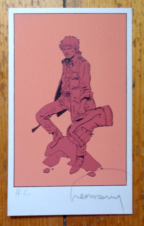
Hermann:
Petite sérigraphie signée.
Petite sérigraphie à l'état de neuf. Tirage nom mentionné, celle-ci marquée HC, signée par Hermann.
Referentie van de boekhandelaar : 5036
|
|
|
HERMANN (Louis) - Dressé par
Plan des communes de la Seine. Banlieue de Paris, région Est. Atlas-guide des 78 communes du département de la Seine.
Paris, Hachette, (1927). In-8, cartonnage de l'éditeur, 125 pp., plans en couleurs.
Referentie van de boekhandelaar : 26011

|
|
|
Hermann:
Voeux de la Tribune de Genève pour le 3e millénaire.
Tribune de Genève, 1999. Carte double au format fermé de 21 x 15 cm.
Referentie van de boekhandelaar : 24397

|
|
|
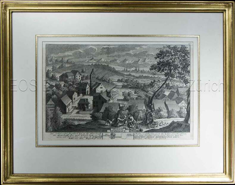
Herrliberger, David:
Weiningen.
1741. Kupferstich. Bildausschnitt: 119 x 28,5 cm. Rahmen: 34,5 x 44 cm.
Referentie van de boekhandelaar : 604BG
|
|
|
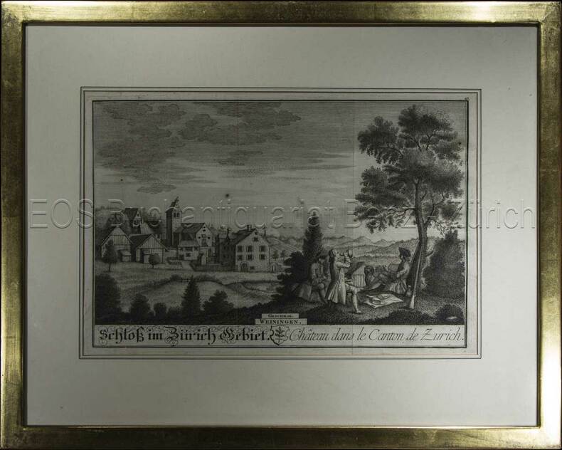
Herrliberger, David:
Weiningen.
1743. Kupferstich. Bildausschnitt: 20 x 28 cm. Rahmen: 33,5 x 42 cm.
Referentie van de boekhandelaar : 605BG
|
|
|
HERALD (George W.) et RADIN (Edward D).
Monte-Carlo : Un siècle de roulette.
Paris, Trévise, Collection "Le dessous des cartes", 1964 ; in-8, broché, couverture illustrée, 265 pp. Planches hors-texte.
|
|
|
Herbert RC. Carr Member of the Alpine Club with illustrations diagrams and sketch maps. Issued by the Climbers' Club. R. C.
A climbers' guide to Snowdon and the Beddgelert District
Burrup Mathieson & Company Ltd 1926. Hardback. Very Good. in x in x in. First thus. Pages clean and bright no markings light wear to edges. Burrup, Mathieson & Company, Ltd hardcover
Referentie van de boekhandelaar : mon0000965725
|
|
|
HERISSON
Carte du Royaume d'Irlande, dressée par Hérisson, Elève du Cit. Bonne, ancien Ingénieur hydrographe de la Marine. 1805
1 grande carte 57 x 85 cm, frontières rehaussées en couleur, Chez Basset, Paris, 1805 Etat très satisfaisant (deux petites coupures en pliure centrale, marges lég. frottée, bel état par ailleurs). Français

|
|
|
Herkenhoff, Michael
Die Darstellung außereuropäischer Welten in Drucken deutscher Offizinen des 15. Jahrhunderts.
Berlin, Akademie-Verlag, 1996. 350 S. Mit Abb. 25 cm. OPp.
Referentie van de boekhandelaar : 95173

|
|
|
Hermann Kinder and Werner Hilgemann; translated by Ernest A. Menze; with maps designed by Harald and Ruth Bukor
The Penguin atlas of world history v. 1 Penguin reference books
Penguin Books N.A. Soft Cover. Fine. Page size: 2 v. Size: 18 cm New book size Penguin Books paperback
Referentie van de boekhandelaar : 2080202103703542
|
|
|
Hermann, John and B/w Illustrations and Maps
Motorcycle Journeys Through the Alps
Paperback. Fine. paperback
Referentie van de boekhandelaar : 37-16KC-MF7A
|
|
|
HERNANDO RICA, Agustín.
Coleccionismo Cartográfico en el Siglo XVII. Ejemplares reunidos por Vincencio Juan de Lastanosa (1607-1681) y su significado.
Huesca, 2007. 4to. apaisado; 92 pp. Ilustraciones. Cubiertas originales.

|
|
|
HERNANDO RICA, Agustín.
La imagen de un país. Juan Bautista Labaña y su Mapa de Aragón (1610-1620).
Zaragoza, IFC, 1996. Folio; 158 pp., impresas a doble columna y 69 reproducciones de mapas. Cubiertas originales.

|
|
|
HERNÁNDEZ MILLARES, Jorge.
Atlas del Viejo Mundo.
México, Fondo de Cultura Económica, 1964. 4to. menor; 58 pp. y 42 mapas aparte. Enc. original en tela.

|
|
|
HERODOTUS; CARY, HENRY (trans) & SCARE, CHRIS (ed) & GEELAN, P J M (maps)
Herodotus: The Histories
The Folio Society 1992. Imp 8vo illus cl bds gilt lettering & ornament to leather spine upper pg edge stained red illus map eps frontispiece xxi 632 pp. plates counted all present VG light soiling/rubbing to spine light rubbing to bords & extrems minor foxing to pg edges in slipcase with gilt ornament to front and back cover VG light chaffing to covers & spine light brusing to exrems & front cover The Folio Society 1992 hardcover
Referentie van de boekhandelaar : 323822
|
|
|
Heron Maps
Birmingham Canal Navigations
like new. unknown
Referentie van de boekhandelaar : 18619822 ISBN : 1908851015 9781908851017
|
|
|
Heron Maps
Birmingham Canal Navigations
new. unknown
Referentie van de boekhandelaar : 18619822-n ISBN : 1908851015 9781908851017
|
|
|
Heron Maps
Birmingham Canal Navigations
Heron Maps 2012. Map. New. 2 pages. 8.54x5.55x0.28 inches. Heron Maps unknown
Referentie van de boekhandelaar : 2-1908851015 ISBN : 1908851015 9781908851017
|
|
|
Heron Maps
Birmingham Canal Navigations
Heron Maps 2012. Map. New. 2 pages. 8.54x5.55x0.28 inches. Heron Maps unknown
Referentie van de boekhandelaar : __1908851015 ISBN : 1908851015 9781908851017
|
|
|
Heron Maps
Canal and River Cruising Planner of Great Britain Waterways Series
like new. unknown
Referentie van de boekhandelaar : 30943042 ISBN : 1908851260 9781908851260
|
|
|
Heron Maps
Canal and River Cruising Planner of Great Britain Waterways Series
new. unknown
Referentie van de boekhandelaar : 30943042-n ISBN : 1908851260 9781908851260
|
|
|
Heron Maps
Canal and River Cruising Planner of Great Britain Waterways Series
Heron Maps 2018. Map. New. 2 pages. 9.45x0.12x0.08 inches. Heron Maps unknown
Referentie van de boekhandelaar : __1908851260 ISBN : 1908851260 9781908851260
|
|
|
Heron Maps
Canal and River Cruising Planner of Great Britain Waterways Series
Heron Maps 2018. Map. New. 2 pages. 9.45x0.12x0.08 inches. Heron Maps unknown
Referentie van de boekhandelaar : 2-1908851260 ISBN : 1908851260 9781908851260
|
|
|
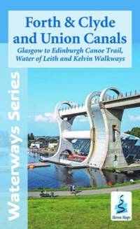
Heron Maps
Forth and Clyde and Union Canals
Paperback / softback. New. New Book; Fast Shipping from UK; Not signed; Not First Edition; N/A paperback
Referentie van de boekhandelaar : ria9781908851246_inp ISBN : 1908851244 9781908851246
|
|
|
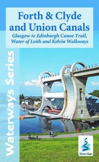
Heron Maps
Forth and Clyde and Union Canals
Paperback / softback. New. paperback
Referentie van de boekhandelaar : A9781908851246 ISBN : 1908851244 9781908851246
|
|
|
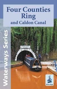
Heron Maps
Four Counties Ring and Caldon Canal Waterways Series
Paperback. Very Good. paperback
Referentie van de boekhandelaar : GOR009615634 ISBN : 1908851155 9781908851154
|
|
|
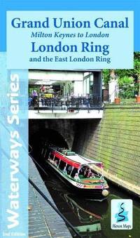
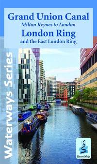
Heron Maps
Grand Union Canal - Milton Keynes to London with the London & East London Rings: Milton Keynes to London and the London Ring Waterways Series
Heron Maps 2021-04-12. 2nd. paperback. Used: Good. 8.62x0.35x5.12. Buy with confidence. Excellent Customer Service & Return policy. Heron Maps paperback
Referentie van de boekhandelaar : SONG1908851309 ISBN : 1908851309 9781908851307
|
|
|
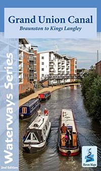
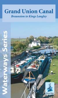
Heron Maps
Grand Union Canal Map - Braunston to Kings Langley
Heron Maps 06/12/2012. Map. Used; Very Good. WE SHIP WITHIN 24 HRS FROM LONDON UK 98% OF OUR ORDERS ARE RECEIVED WITHIN 7-10 DAYS. We believe you will be completely satisfied with our quick and reliable service. All orders are dispatched as swiftly as possible! Buy with confidence! Greener Books. Heron Maps unknown
Referentie van de boekhandelaar : 4929954 ISBN : 1908851031 9781908851031
|
|
|
Heron Maps
Grand Union Canal - Milton Keynes to London with the London & East London Rings: Milton Keynes to London and the London Ring Waterways Series
like new. unknown
Referentie van de boekhandelaar : 42640967 ISBN : 1908851309 9781908851307
|
|
|
Heron Maps
Grand Union Canal - Milton Keynes to London with the London & East London Rings: Milton Keynes to London and the London Ring Waterways Series
new. unknown
Referentie van de boekhandelaar : 42640967-n ISBN : 1908851309 9781908851307
|
|
|
Heron Maps
Grand Union Canal
Paperback / softback. New. New Book; Fast Shipping from UK; Not signed; Not First Edition; paperback
Referentie van de boekhandelaar : ria9781908851307_inp ISBN : 1908851309 9781908851307
|
|
|
Heron Maps
Grand Union Canal - Milton Keynes to London with the London & East London Rings: Milton Keynes to London and the London Ring Waterways Series
Heron Maps 2021. Paperback. New. 2nd edition. 2 pages. 8.66x5.12x0.43 inches. Heron Maps paperback
Referentie van de boekhandelaar : 2-1908851309 ISBN : 1908851309 9781908851307
|
|
|
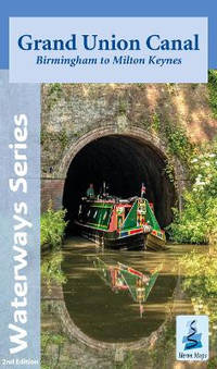
Heron Maps
Grand Union Canal: Birmingham to Milton Keynes
Paperback / softback. New. paperback
Referentie van de boekhandelaar : A9781908851369 ISBN : 1908851368 9781908851369
|
|
|
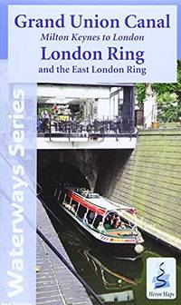
Heron Maps
Grand Union Canal: Milton Keynes to London and the London Ring
Paperback / softback. New. paperback
Referentie van de boekhandelaar : A9781908851307 ISBN : 1908851309 9781908851307
|
|
|
Heron Maps
Grand Union Canal: Braunston to Kings Langley
Paperback / softback. New. paperback
Referentie van de boekhandelaar : A9781908851345 ISBN : 1908851341 9781908851345
|
|
|
Heron Maps
Grand Union Canal - Milton Keynes to London with the London & East London Rings: Milton Keynes to London and the London Ring Waterways Series
Heron Maps 2021. Paperback. New. 2nd edition. 2 pages. 8.66x5.12x0.43 inches. Heron Maps paperback
Referentie van de boekhandelaar : __1908851309 ISBN : 1908851309 9781908851307
|
|
|
Heron Maps
Grand Union Canal - Milton Keynes to London: With the London and East London Rings
Paperback. Very Good. paperback
Referentie van de boekhandelaar : GOR007646839 ISBN : 190885104X 9781908851048
|
|
|
Heron Maps
Grand Union Canal: Braunston to Kings Langley
Paperback. Very Good. paperback
Referentie van de boekhandelaar : GOR004813006 ISBN : 1908851031 9781908851031
|
|
|
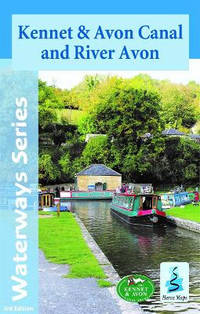
Heron Maps
Kennet and Avon Canal: And River Avon Waterways Series
Heron Maps 2021-12-01. 3rd. map. Used: Good. 8.70x0.24x5.55. Buy with confidence. Excellent Customer Service & Return policy. Heron Maps unknown
Referentie van de boekhandelaar : SONG1908851376 ISBN : 1908851376 9781908851376
|
|
|
Heron Maps
Kennet and Avon Canal: And River Avon Waterways Series
Heron Maps 2021. Map. New. 3rd edition. 2 pages. 8.27x5.59x0.79 inches. Heron Maps unknown
Referentie van de boekhandelaar : 1-1908851376 ISBN : 1908851376 9781908851376
|
|
|
Heron Maps
Kennet and Avon Canal: And River Avon Waterways Series
new. unknown
Referentie van de boekhandelaar : 44431646-n ISBN : 1908851376 9781908851376
|
|
|
Heron Maps
Kennet and Avon Canal: And River Avon Waterways Series
like new. unknown
Referentie van de boekhandelaar : 44431646 ISBN : 1908851376 9781908851376
|
|
|
Heron Maps
Kennet and Avon Canal
Paperback / softback. New. New Book; Fast Shipping from UK; Not signed; Not First Edition; N/A paperback
Referentie van de boekhandelaar : ria9781908851376_inp ISBN : 1908851376 9781908851376

|
|
|
Heron Maps
Kennet and Avon Canal: And River Avon
Paperback / softback. New. paperback
Referentie van de boekhandelaar : A9781908851376 ISBN : 1908851376 9781908851376
|
|
|
Heron Maps
Kennet and Avon Canal: And River Avon Waterways Series
Heron Maps 2021. Map. New. 3rd edition. 2 pages. 8.27x5.59x0.79 inches. Heron Maps unknown
Referentie van de boekhandelaar : __1908851376 ISBN : 1908851376 9781908851376
|
|
|
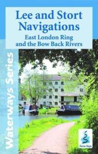
Heron Maps
Lee and Stort Navigations
Paperback / softback. New. New Book; Fast Shipping from UK; Not signed; Not First Edition; N/A paperback
Referentie van de boekhandelaar : ria9781908851291_inp ISBN : 1908851295 9781908851291
|
|
|
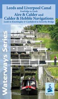
Heron Maps
Leeds and Liverpool Canal - Foulridge to Leeds with the Aire and Calder and Calder and Hebble Navigations from Leeds to Knottingley and Castleford to Sowerby Bridge Waterways Series
Heron Maps 2014. Map. New. 2 pages. 8.27x5.04x0.32 inches. Heron Maps unknown
Referentie van de boekhandelaar : 2-1908851090 ISBN : 1908851090 9781908851093
|
|
|
Heron Maps
Leeds and Liverpool Canal - Foulridge to Sowerby Bridge: Aire and Calder and Calder and Hebble Navigations from Leeds to Knottingley and Castleford to Sowerby Bridge
Sheet map folded. New. unknown
Referentie van de boekhandelaar : A9781908851093 ISBN : 1908851090 9781908851093
|
|
 De zoekresultaten per email ontvangen
 Zoekresultaten downloaden als PDF
 RSS feed


