|
HOUPLAIN (Jacques).
Carte de voeux illustrée d'une gravure originale signée.
Paris Société des peintres-graveurs français 1989 1 vol. Broché Longue carte de voeux dépliante sur Arches illustrée d'une eau-forte (9 x 25 cm) justifiée 69/200 et signée par Jacques Houplain. En parfait état.
Riferimento per il libraio : 109094
|
|
|
HOUPLAIN (Michel).
Menu illustré d'une gravure originale signée.
Paris Les Impénitents 1983 2 vol. Broché Menu dépliant sur Arches illustré d'une eau-forte (7.5 x 13 cm) signée par Michel Houplain. . En parfait état.
Riferimento per il libraio : 109171
|
|
|
HOUPLAIN (Michel).
Menu illustré d'une gravure originale signée.
Paris Les Impénitents 1983 2 vol. Broché Menu dépliant sur Arches illustré d'une eau-forte (7.5 x 13 cm) signée par Michel Houplain. . En parfait état.
Riferimento per il libraio : 109171
|
|
|
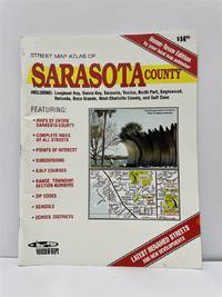
House Of Maps
Street Map Atlas of Sarasota County Including Longboat Key Siesta Key . and Gulf Cove
House of Maps. Good. 1998. Unknown Binding. 8vo 8" - 9" tall; The book is in great overall condition showing only minor cosmetic wear.; - We're committed to your satisfaction. We offer free returns and respond promptly to all inquiries. Your item will be carefully wrapped in bubble wrap and securely boxed. All orders ship on the same or next business day. Buy with confidence. . House of Maps unknown
Riferimento per il libraio : OS-6693-TOB4-0.73 ISBN : 0783418264 9780783418261
|
|
|
Housman, John (1764-1802).
A DESCRIPTIVE TOUR, AND GUIDE TO THE LAKES, CAVES, MOUNTAINS, AND OTHER NATURAL CURIOSITIES, IN CUMBERLAND, WESTMORELAND, LANCASHIRE, AND A PART OF THE WEST RIDING OF YORKSHIRE. The Second Edition, Embellished with Several Additional Plates.
pp. v, (4), 226, (2) + Plus engraved Frontis, Plates of scenes and large folding maps and charts. One map includes the sketch of soils, canals, etc of Lancashire. LACKS full page plate of Furness Abbey. View of Keswick Lake repeated on page 107 and 125. View of Bassenthwaite omitted. Two pages have old tape repairs with no loss. Map of the districts has small tape repair on one fold. Offsetting from Frontis on title page. Age stained and foxed. Engraved amoral bookplate of William Scott Elliot of Arkleton. 8vo. 215 mm. Original full leather binding. Boards detached. Small loss on spine. Binding worn. Hardbound. A rather poor copy of a great book. SCARCE. **PRICE JUST REDUCED! TRAVEL/7
|
|
|
HOWARD-BURY C. K:
Mount Everest: die Erkundungsfahrt 1921. Deutsch von W. Rickmer Rickmers.
Basel, Schwabe, 1922. Grand in-8 de VIII-299 pages, cartonnage d'éditeur.
Riferimento per il libraio : 19829

|
|
|
Howe, C.D.; White, J.H.
Trent Watershed Survey: A Reconnaissance
156 pages. Index. Excellent black and white photos. Nice colour map entitled "Forest Distribution in Trent River Watershed" (34"x36") stored in pocket inside back board. Also present is a colour map entitled "Crown Timber Lands 1912" which covers the same geography and measures 21"x20". Final item in pocket is a chart showing "Classification of Land, Trent Watershed, Ont. 1912". Gilt lettering upon backstrip and front board. Initials upon front free endpaper else unmarked. Binding sound. Average wear. Sound copy. Book

|
|
|
Howell, Arthur H.
FLORIDA BIRD LIFE.
pp. xxiv, 579 + Color plates after paintings by Francis L. Jaques, with guards and explanations + Photographic plates + Folding colored map. Small 4to. 25 cm. Plain cloth binding. "Florida occupies a unique position biologically among the States of the Union and has been a Mecca for naturalists. Comprising a long narrow peninsula projecting southward into the tropics, and provided with myriad lakes, ponds, marshes, and tidal lagoons, it is an attractive lane of migration for many birds and furnishes an ideal home at all seasons for immense numbers of waterfowl, shorebirds, and swamp-loving species." - Introduction. A nice clean copy of a invaluable work that contains a description of each bird found in Florida, with: its range, distribution, haunts, habits, food, recognition marks, etc. Ripley 138. NH7
|
|
|
Hoyerswerda:
Hoyerswerda. "Plan der Action welche d. 25. September 1759 zwischen dem Oesterreichischen und einem Königl.Preussischen Corps bei Hoyerswerda in Sachsen vorgefallen". Schlachtenplan von Hoyerswerda. Kupferstich mit farbigen Truppenaufstellungen aus "Neues Kriegs-Theater ...", 13. Supplement.
Format: 18 x 29,5 cm. *Leicht gebräunt, insgesamt gut erhalten. Landkarten de
|
|
|
Hoyler, H.M.; Long, F.A.; Moore, R.; Pierce, P.N.; Fitzgerald, E.F.; Liggett, T. Jr.; Wismer, R.H.; Moore, C.E.; Dodd, Joe
Marine Corps Gazette - Professional Magazine for United States Marines, April (Apr.) 1960, Number 4, Volume 44 - Sikorsky S-60 Sky Crane
72 pages. Features: 1960 Slates; Fort Lejeune fold-out cover illustration; and more. High Standard Manufacturing Corporation ad features photos of shooting prize winners Santiago Machuca, John C. Forman, David Cartes, Aubrey E. Smith, Roy Ratliff, and Richard Stineman; The Jet Age Wall - Are SAC and the ICBM offensive or defensive?; Embarkation Planning; The Marine Reserve; Peacetime Heroes; Report from the Ready Forces, The 2d Marine Division - Part I - Combat Readiness, and Part II - Programs to Improve Readienss; Write it Right; Your Ideas Wanted; The Salty Skipper; Brainstorming; Better Reserve Training; Sky Crane - the Sikorsky S-60; and more. Average wear. Unmarked. A sound vintage copy. Magazine

|
|
|
Hoys, Dudley
English Lakeland in Colour
Inscription inside front board. No other marks. A very clean very tight copy with bright unmarked boards and no bumping to corners. Dust jacket not price clipped or marked or torn with very minor creasing to lower front edge. 95pp. Half of the book is a description of the Lakes and its history and the other half is a series of full-page colour photographs and detailed notes on each.

|
|
|
HOÜEL Jean-Pierre-Louis-Laurent:
Voyage pittoresque des isles de Sicile, de Malte et de Lipari: où l'on traite des antiquités qui s'y trouvent encore, des principaux phénomènes que la nature y offre, du costume des habitants, & de quelques usages.
A Paris, de l'imprimerie de Monsieur, 1782 - 1787. 4 volumes grand in-folio de VIII-138; [4]-148; [4]-126; [4]-124 pages, demi-chagrin vert, dos lisses orné de filets et fleurons dorés. Non rogné. Reliures restaurées.
Riferimento per il libraio : 18751

|
|
|
Hryniuk, Angela
No Visual Scars
79 pages. "A responsively irritable record of how it is to live bodily life now that the old maps don't tell us the truth. Hryniuk writes with intelligence and conscience. Her book has startling insights to offer." - Brian Fawcett. Clean and unmarked with light wear. Nice copy. Book
|
|
|
Huber, Caspar Ulrich (1825-1882)
Silvaplana mit See gegen den Piz della Margna.
Zürich, Henri Füssli & Comp., um 1860. Altkolorierte Aquatinta auf festem Papier. 16 x 23,4 cm. + Wichtig: Für unsere Kunden in der EU erfolgt der Versand alle 14 Tage verzollt ab Deutschland / Postbank-Konto in Deutschland vorhanden +, bild
Riferimento per il libraio : 704CG

|
|
|
HUDSON'S BAY COMPANY
Canada; to Commemorate Our 322nd Birthday; Road Atlas Plus 6 Postcards
folio [39 x 28 cm]; unpaginated, national map, maps of each province, inset maps of main cities, all maps in color, mileage chart, legend, index of towns and cities. original pictorial printed heavy paper wraps with title historic map showing trading posts, etc on cover, name on margin, near fine and clean with the postcards intact. A picture of this book is available upon request by email. This copy has the 4 page insert of ads from The Bay that was included with the atlas.
|
|
|
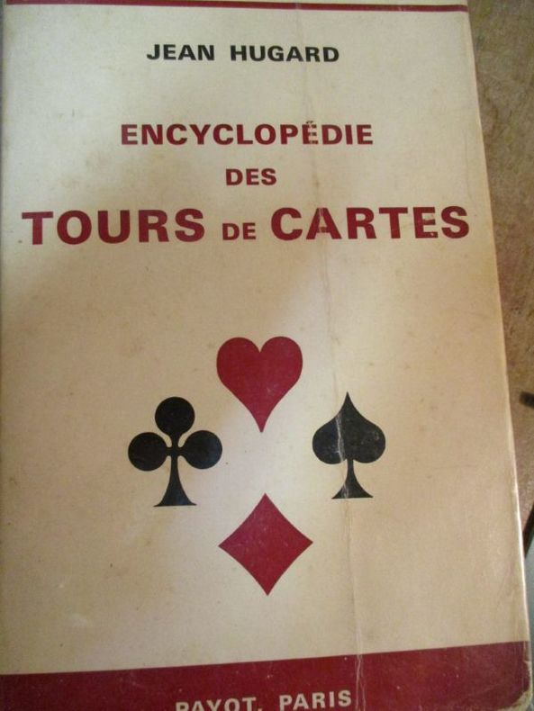
Hugard (Jean)
Encyclopédie des tours de cartes
1970 Paris Payot 1970 In8 broché 434 pages
Riferimento per il libraio : 6339
|
|
|
HUGARD (Jean)
Encyclopédie des Tours de Cartes.
Publiée avec la collaboration de John J. Crimmins, Jr. . Traduction et préface de Maurice Sardina. Paris, Payot, 1964. Grand in-8 (23x3x14,5cm) broché couverture illustrée. 434pp.
Riferimento per il libraio : WOC-2622

|
|
|
HUGARD (Jean) & BRAUE (Frédéric)
La Technique Moderne aux Cartes.
Ouvrage illustré de 351 figures par Donna Allen et Clayton Rawson. Traduction et préface de Maurice Sardina. Paris, Payot, 1955. Grand in-8 (23x2,5x14,5cm) broché de couverture d'édition illustrée. 511pp.
Riferimento per il libraio : WOC-2621

|
|
|
HUGARD Jean - BRAUE Frederick
La technique moderne aux cartes
Paris, Genève, Champion - Slatkine, 1987, in-8 rel. skiv. bleu marine (15 x 22,5), 511 p., coll. "Bibliothèque des classiques de la magie et de la prestidigitation", réimpression de l'édition de Paris de 1955, traduction et préface de Maurice Sardina, illustré de 351 figures par Donna Allen et Clayton Rawson, bon état.
Riferimento per il libraio : QWA-18833

|
|
|
Huggan, Graham
Territorial Disputes : Maps and Mapping Strategies in Contemporary Canadian and Australian Fiction (Theory/Culture Ser.)
198 pages including index. Maps and mapping strategies in Contemporary Canadian and Australian fiction. Examines maps as ambivalent symbols of national culture, as vehicles for the representation of cultural history, and as often self-parodic analogues for the literary text. Clean, bright and fresh copy in attractive green cloth boards. Small chips from upper edge of dust jacket back panel. An excellent copy. Book

|
|
|
Huggins, K. H. Et al
COLLINS-LONGMANS STUDY ATLAS
London 1965. Atlas. Very Good. Hardcover. Fifteenth Edition. 4to. Fifteenth Edition with Colour photograph colour maps throughout. Dust jacket good with some general wear and some chipping and associated creasing to edges 3cm missing from top of spine now protected in an archival sleeve and looks good. Original red cloth binding with gilt lettering excellent having been protected by the dust jacket. Contents clean and tight. A very good copy in a good dust jacket. Hardcover
Riferimento per il libraio : 006383
|
|
|
Hughes, Pennethorne
The Isle of Wight : A Shell Guide
No marks or inscriptions. No creasing to covers or to spine. A very clean very tight copy with bright unmarked boards and no bumping to corners. Dust jacket price clipped but not marked or torn or creased with slight rubbing to upper edge. Jacket now protected in fully-removable transparent sleeve. 78pp. First edition, first printing of the classic Shell Guide to the Isle of Wight.

|
|
|
HUGHES, WILLIAM.
A Manual of Mathematical Geography comprehending an Inquiry into the Principles of Mathematical Geography with Rules for the Formation of Map-Projections
London.: Longman Brown Green & Longmans. Second Edition. 1852. 5 folding mathematical projections at the rear. v 143pp plus 5 pages of publisher's adverts. Original cloth lettered in gilt on the spine and ruled in blind title page slightly browned head & tail of spine slightly chipped else a lovely clean copy. A presentation copy "With the Author's Cordial Regards' dated July 6th" 1854. 17.5x 10.5cm Born in Westminster London in 1818 William Hughes was a prolific mapmaker geographer engraver printer and publisher. . Longman, Brown, Green, & Longmans. hardcover
Riferimento per il libraio : 180552
|
|
|
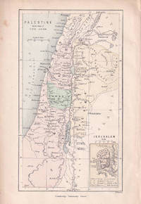
HUGHES, WILLIAM.
Palestine in the time of our Lord.
Cambridge University Press. circa1880. Engraved colour map 14.1x 8.2 cm map small inset map of Jerusalem inner edge a trifle ragged and two small marginal spots but in good condition. . Cambridge University Press. unknown
Riferimento per il libraio : 176611
|
|
|
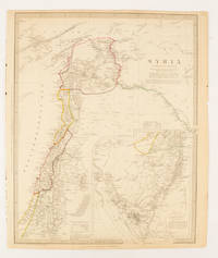
HUGHES, WILLIAM (CREATOR) WITH BURCKHARDT, JOHN LEWIS; CHESNEY, CHARLES CORNWALLIS; RENNELL, JAMES & ROBINSON, EDWARD.
Syria.
London.: Chapman & Hall. 1843. Engraved map with outline hand colour 39.4 x 31.4 cm inset map "Continuation from the Dead Sea to Mount Sinai" with finely engraved notes and a key to the Divisions under control of the Turkish Government manuscript pagination in an early hand to the top right edge tear nicks and browning but in very good condition. A most attractive map with detailed notes published when Syria was still under control of the Ottoman Empire. . Chapman & Hall. unknown
Riferimento per il libraio : 174934
|
|
|
HUGHES, WILLIAM.
The World on Mercators Projection showing both the Eastern & Western Maritime Route to Australia and the difference of Time at succesive Hour-Circles east & west of Greenwich.
London.: Virtue & Co. circa1874. Printed colour map 18.4 x 24.1 cm edge wear marginal spotting and on the verso but the map in very good condition. Unusual map showing time differences east and west of Greenwich before the atomic clock and well before satellites! The explanatory text notes aso that: "The space comprehended between the meridiens of 120 & 160 E. is repeated in order to show the relative position of England to Australia both eastward and westward." . Virtue & Co. unknown
Riferimento per il libraio : 174897
|
|
|
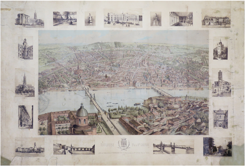
HUGO d'ALESI (Frédéric Alexianu dit).
[TOULOUSE] Toulouse. D.t de la H.te-Garonne.
1886. 630 x 912 mm.
Riferimento per il libraio : LBW-7031
|
|
|
HUGO. Abel.
France pittoresque
HUGO. Abel. France pittoresque ou description topographique et statistique de départements et colonies de la France, offrant un résumé pour chaque département et colonie l’histoire, les antiquités, la topographie, la météorologie, l’histoire naturelle, la division politique et administrative, la description générale et pittoresque du pays, la description particulière des villes, bourgs, communes et châteaux. Celle des mœurs, coutumes et costumes etc. avec des notes sur les langues, idiomes et patois, sur l’instruction publique et bibliographie locale, sur les hommes célèbres. Etc. Et des enseignements statistiques sur la population, l’industrie, le commerce, l’agriculture, la richesse territoriale, les impôts etc. etc. accompagnée de la statistique générale de la France, sur le rapport politique, militaire, judiciaire, financier, moral, médical, agricole, industriel et commercial. 3 tomes en 3 volumes in 8 demi-cuir, titre, roulette, tomaison, filets dorés pour les tomes 1 et 2. Reliure plein cuir fauve raciné, pièce de titre cuir rouge pour le tome 3. Tome 1 : titre, VII, 320 pages, texte sur 2 colonnes. Nombreuses figures hors-texte, 3 cartes dépliantes de départements. Pâle mouillure en début de volume. Coiffe inférieure manquante. Tome 2 : titre 32 0pages Nombreuses figures hors-texte, cartes. Mouillure page de titre et table des matières (en marge inférieure de la page 266 à la fin du volume). Tome3 : titre, 320 pages, gravures hors-texte, cartes. Petite mouillure circulaire en début de volume, en diminuant, jusqu’à la page 46. Pour les trois volumes : 363 portraits, 94 cartes de régions, 8 plans de villes, 3 cartes, les Antilles Françaises, La Guyane, Madagascar. HUGO. Abel. France pittoresque.. . Chez DELLLOYE éditeur de la France militaire 1833. Dans l’état.
Riferimento per il libraio : 13435

|
|
|
HUGUENIN (Oscar) par Eric-André KLAUSER.
Oscar HUGUENIN (1842-1903), imagier du pays de Neuchâtel. Croquis, cartes postales et autres ...
Saint-Blaise, éd. du Ruau 1992. Bel exemplaire relié, cartonnage orné d'éd., in-4, 112 pages avec annexes.
Riferimento per il libraio : AUB-6621
|
|
|
HUGUENIN Paul:
Raiatea la sacrée. Îles Sous le Vent de Tahiti (Océanie française).
Neuchâtel, Imprimerie Paul Attinger, 1902. Petit in-4 de.256 pages, demi-percaline rouge, dos (frotté) lisse, premier plat de couverture illustrée en couleurs conservée.
Riferimento per il libraio : 19858

|
|
|
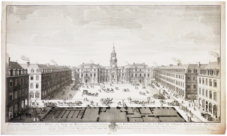
HUGUET (Jean-François).
[RENNES] Élévation perspective de l'Hôtel de Ville de Rennes dans lesquels se tiendront les États de la province, de la Tour de l'Orloge public et du Présidial, construits dans la Place Neuve.
Paris, V.ve de F. Chéreau, 1738. 332 x 563 mm.
Riferimento per il libraio : LBW-5405
|
|
|
HULBERT, Archer Butler, Illustrated by Maps
FORTY-NINERS The Chronicle of the California Trail
Boston: Little Brown And Company 1931. First Edition. Very Good/very good. Octavo; xvii 340 pages green cloth. Ex libris J. Willis Guyton. <br/><br/>Splendid account of the travails of the Argonauts based on their diaries and journals. "To prepare this chronicle of the California gold rush the California Trail was divided into eight sections represented by the eight maps here reproduced on a scale of thirty miles to an inche. Then every available diary or journal was read for the light it might shed on pioneer experience in the region covered by Section 1. In turn that process was repeated eight times. The result was a story of actual experience covering 2200 miles of plain desert butte mountain river and ravine. In addition to consulting this source material the writer has traveled most of the trail himself mile by mile several times." - Preface. Little, Brown And Company hardcover
Riferimento per il libraio : 0011555
|
|
|
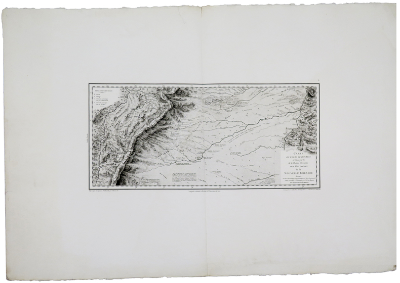
HUMBOLDT (Frédéric-Henri-Alexandre, baron de).
[COLOMBIE/BOGOTA] Carte du cours de Rio Meta et d'une partie de la chaîne orientale des montagnes de la Nouvelle Grenade.
[Paris], 1813. 232 x 495 mm.
Riferimento per il libraio : LBW-5880
|
|
|
HUMBOLDT (Frédéric-Henri-Alexandre, baron de).
[MEXIQUE/MEXICO] Carte de la vallée de Mexico et des montagnes voisines esquissée sur les lieux en 1804, par Don Louis Martin.
Paris, 1808. 392 x 457 mm.
Riferimento per il libraio : LBW-5869

|
|
|
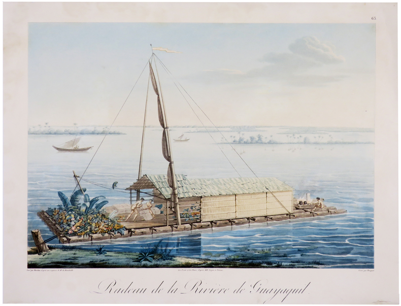
HUMBOLDT (Frédéric-Henri-Alexandre, baron de).
[ÉQUATEUR/GUAYAQUIL] Radeau de la rivière de Guayaquil.
[1810]. 335 x 411 mm.
Riferimento per il libraio : LBW-6012
|
|
|
HUNKLER Robert
L'alsace à La Belle Époque
Bruxelles S.P.R.L.M. Sodim 1976 In-8 151 pp, reproductions de cartes postales en noir et blanc
Riferimento per il libraio : 30372
|
|
|
Hunt, Lindsay & Phillips, Laurence
The AA Key Guide to Brittany
No marks or inscriptions. No creasing to covers or to spine. A very clean very tight copy with bright unmarked boards and no bumping to corners. 222pp. Brittany's sights, restaurants, bars, hotels, shopping, walks, tours, trains, buses and Metro in a beautifully laid out guide with user-friendly maps.

|
|
|
Hunter, W. V.
Exploring Cornwall with Your Car
Booklet in mint unused condition. 48pp.

|
|
|
HUNTINGDONSHIRE - BLAEU, J.W.
Huntingdonensis Comitatus. Huntington Shire.
(Amsterdam, 1645 or later). 39,2x50 cm. Fine engraved map over Huntingdon, broad margins, fine orig. handcolouring. Clean. Large cartouche with dogs and huntingscenes. Map decorated with many large coats of arms.
|
|
|
HUNTINGDONSHIRE - BLAEU, J.W.
Huntingdonensis Comitatus. Huntington Shire.
(Amsterdam, 1645 or later). 39,2x50 cm. Fine engraved map over Huntingdon, broad margins, fine orig. handcolouring. Clean. Large cartouche with dogs and huntingscenes. Map decorated with many large coats of arms.
Riferimento per il libraio : 25260
|
|
|
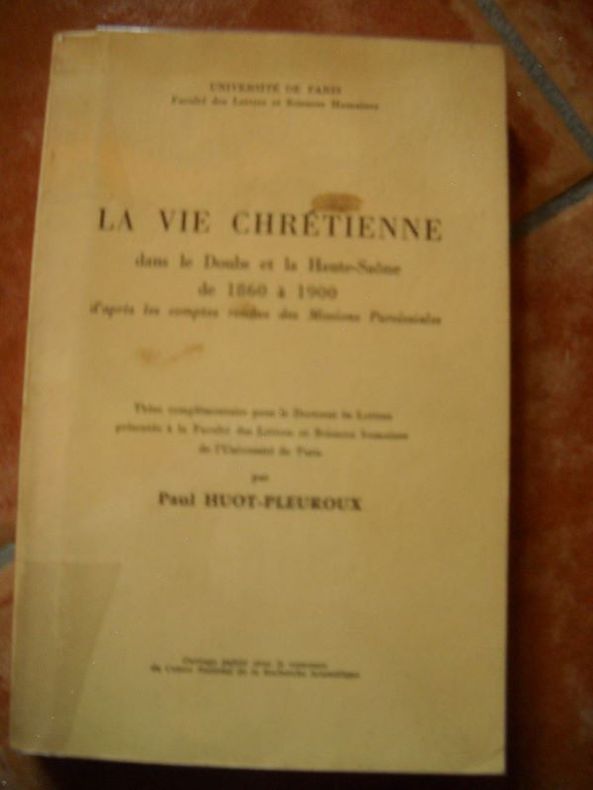
HUOT-PLEUROUX PaulLA VIE CHRETIENNE Dans Le DOUBS et La HAUTE-SAÔNE De 1860 à 1900, D'après Les Comptes Rendus Des Missions ParoissialesFaculté Des Lettres et Sciences Humaines In-8 Couverture Imprimée Paris 1966 Ouvrage broché, thèse complémentaire pour le doctorat ès lettres présentée àla faculté des lettres et sciences humaines de l'université de Paris, deux cartes dont un double d echacune sur papier calque figurent in fine,381 pages, état d'usage - Prix : 45,00 EUR Commander
LA VIE CHRETIENNE Dans Le DOUBS et La HAUTE-SAÔNE De 1860 à 1900, D'après Les Comptes Rendus Des Missions Paroissiales
brocheé - 15.5x24 - 381pp - 1966 - université de Paris
Riferimento per il libraio : 10890
|
|
|
HUSSON (Pierre);
[PAYS-BAS] Carte générale des Provinces Unies des Pais Bas & des terres voisines qui en dépendent avec leurs principales divisions.
La Haie circa 1710 500 x 575 mm.
Riferimento per il libraio : LBW045cc

|
|
|
Hutchinson, Bruce maps: MacDonald, James
STRUGGLE FOR THE BORDER
New York NY: Longmans Green & Company. G/NO DUSTJACKET. 1955. First Edition. Cloth. 8vo. 500 pp. cover worn and stained some . Longmans, Green & Company hardcover
Riferimento per il libraio : BOOKS239767
|
|
|
Hutchinson, Joseph . [et al.]
Resource Development in Semi-Arid Lands : A Royal Society Discussion Organized by Sir Joseph Hutchinson, F.R.S., A.H. Bunting, A. R. Jolly and H.C. Pereira, F.R.S.
vii + 176 pages, illustrated, previous owner details on the front endpaper. Not ex library. eng
|
|
|
Hutchinson, Walter: Editor
Hutchinson's Pictorial History of the War, Series 3, No. 3, January 3, 1939 - , January 9, 1940
40 pages. Circa 1940s. 77 black and white photos and illustrations. Printed on glossy stock. Features: Ad for Mein Kampf, part 3, inside front cover; The army of France at the front; Ministerial and R.A.F. changes - photos of A.S. Barratt, Sir John Reith, Oliver Stanley and Sir Andrew Rae Duncan; Full-page photo of France honouring Sir Edmund Ironside and Lord Gort; Contraband control strangling Germany's tradep Nazi watch on the western front; Text of speech by Lord Snell entitled "The British Empire - In War and After"; Photo portrait of Admiral Sir Charles Forbes; Lumberjacks of the Land Girls Army; British tank gunners in training; Admiral Graf Spee visitors pay courtesy visits - the Ajax in Montevideo and the Achilles in Buenos Aires; Centerfold maps illustrate European industrial targets and bases most vulnerable to raids; At an R.A.F. Aerodrome in France; Norway prepares to defend her neutrality - 12 great photos; photo of partially submerged vessel Dunbar Castle which struck a German mine; photo of bombed Trinity House vessel which was attacked by a Nazi plane on January 9th; Illustrated article - The Royal Army Chaplain's Department; At an R.A.F. fighter station; A 25-pounder shoot at the front; Commentary on the war this week; Finland's fight for freedom - 8 excellent photos including one of a Soviet amphibious tank; Summary of the chief events of this week. Average wear. Unmarked. A sound copy. Book

|
|
|
HYDROGEOLOGIE du BASSIN de l'AREUSE par André BURGER.
Hydrogéologie du bassin de l'Areuse. Richement documenté (héliogravures, figures, cartes dépliantes).
Neuchâtel 1959. Bel exemplaire relié, in-8, 304 pages + planches.
Riferimento per il libraio : AUB-6528
|
|
|
HYMANS Louis:
Bruxelles à travers les âges.
Bruxelles, Bruylant-Christophe et Cie, sans date. 2 volumes in-4 de 484 + 466 pages, demi-maroquin marron, dos à nerfs ornés, plats frappés du titre en lettres dorées et encadrés à froid, tranches dorées. Mors 1er plat vol. 1 légèrement fendu et frotté, accroc à la coiffe inf. vol. 1, mors 1er plat vol. 2 légèrement fendu et frotté.
Riferimento per il libraio : 2063

|
|
|
Hélias Pierre Jakez
Dictionnaire des Saints Bretons
Tchou 1979 394 pages 17x26x5cm. 1979. Broché. 394 pages. Ouvrage de Henri Queffélec publié en 1969 par André Balland présentant une étude historique et artistique des hauts-lieux de la Bretagne. Le livre contient une importante iconographie et une carte dépliante offrant une exploration des sites traditionnels et patrimoniaux de la région
Riferimento per il libraio : 100149329

|
|
|
Hérisson
carte de Paris et ses environs contenant le département de la Seine et une partie du département de la Seine et Oise.
Jolie carte de Paris et ses environs contenant le département de la Seine et une partie du département de la Seine et Oise. Par Hérisson, à Paris chez Lenoir Dans un petit livret cartonné, 12x7cm, la carte dépliée 42,5x31cm, petite coupure et restauration au dos, sinon bel état, sans date vers 1810.
Riferimento per il libraio : CZC-13045

|
|
|
Hérisson
carte de Paris et ses environs contenant le département de la Seine et une partie du département de la Seine et Oise.
Jolie carte de Paris et ses environs contenant le département de la Seine et une partie du département de la Seine et Oise. Par Hérisson, à Paris chez Lenoir Dans un petit livret cartonné, 12x7cm, la carte dépliée 42,5x31cm, petite coupure et restauration au dos, sinon bel état, sans date vers 1810.
Riferimento per il libraio : CZC-13045
|
|
 Ricevere i risultati per e-mail
 Scaricare i risultati in PDF
 RSS feed


