|
Hill, Gillian & Tyacke, Sarah
Cartographical Curiosities
No marks or inscriptions. Tiny crease to upper corner of rear cover, none to front. A lovely clean very tight copy with bright unmarked boards and no bumping to corners. 63pp. A survey of some of the more unusual maps in the British Library, whether based on genuine geographical misconceptions or the deliberate whimsy of cartographers.

|
|
|
HILLARY, EDMUND & DJURKOUIC, GEORGE (Sketches) & SPARK, A (Maps)
High Adventure
Readers Book Club 1957. Octavo hardcover VG- in d/w G jacket scruffy: all our specials have minimal description to keep listing them viable. They are at least reading copies complete and in reasonable condition but usually secondhand; frequently they are superior examples. Ordering more than one book will reduce your overall postage costs. Readers Book Club 1957 hardcover
Riferimento per il libraio : 355305
|
|
|
HILLARY, EDMUND & SPARK, A (Maps) & DJURKOUIC, GEORGE (Sketches)
High Adventure
Hodder & Stoughton 1955. FIRST EDITION octavo hardcover VG in d/w VG-; all our specials have minimal description to keep listing them viable. They are at least reading copies complete and in reasonable condition but usually secondhand; frequently they are superior examples. Ordering more than one book may reduce your overall postage costs. Hodder & Stoughton 1955 hardcover
Riferimento per il libraio : 317268
|
|
|
HILLIARD, J.N.
La Prestidigitation du XXe siècle. Tours de cartes modernes. Cartes, éventails, toutes les manipulations et passes modernes, faux mélanges, sauts de coupe, forçages, etc., toutes les subtilités modernes supprimant les passes, tours anciens modernisés, tou
in-8, 573 pp., figures dans le texte, broche, couv. ill. Etat tres moyen [NV-37] Manuscrit et notes publies par Carl W. Jones et Jean Hugard.
|
|
|
HINZELIN Emile Cartes et panoramas dépliants.
1914. Histoire illustrée de la guerre du droit. (En 3 volumes).
Couverture rigide. Reliure de l'éditeur. 1200 pages. Rousseurs. 21 x 28 cm.
Riferimento per il libraio : 116839

|
|
|
Hinde, W. Squire, J. Marshall, Thomas Cooke M.
To face Globe
Tavola astronomica tratta dall’A New Royal and Universal Dictionary of Arts and Sciences, London 1770-1771, Printed of J. Cooke Si tratta di un’opera in due grandi volumi, cm 35,5 x 23,5, rispettivamente pubblicati a Londra nel 1770 e nel 1771, che raccoglie in ordine alfabetico alcune centinaia di voci illustranti sia le conoscenze scientifiche e tecnologiche che lo sviluppo delle arti e dei mestieri dell’epoca. Le singole voci, scritte dai più autorevoli esperti europei, sono state poi riviste e redazionate da M. Hinde per il settore relativo all’anatomia, medicina e chimica, da W. Squire per le matematiche, da T. Marshall per la Botanica e da Thomas Cooke per le materie umanistiche. Centouno tavole prodotte da relative incisioni su rame illustrano i due volumi. Le incisioni, equamente ripartite sui vari saperi, riproducono sia soggetti della natura che i più aggiornati strumenti usati per indagarla. Una considerevole parte riguarda invece gli strumenti di lavoro delle varie arti e mestieri. L’opera è giunta a noi in pochissimi esemplari, se ne conoscono soltanto ventitré copie, in quanto le piastre in rame furono in un primo momento confiscate, prima della stampa, dalla Court of Chancery of London in conseguenza del fallimento dell’editore di Bevis, Johan Neale. Le ventitré copie conosciute fanno parte di una tiratura prodotta successivamente nel 1786 da John Horsfall, l’esecutore testamentario di Bevis, con il titolo di Atlas Celeste. Per il momento è ancora da ricostruire la storia di come le dodici tavole contenute nell’A New Royal and Universal Dictionary of Arts and Sciences abbiano potuto anticipare di circa quindici anni la diffusione degli originali che imitano. L’enciclopedia, oggi abbastanza rara e quasi non indagata dalla critica, subì l’influsso della più conosciuta e più antica Cyclopaedia: Or An Universal Dictionary of Arts and Sciences di Ephraim Chambers (ca. 1680-1740), pubblicata in Inghilterra nel 1728 (cfr. Felice Stoppa, Atlas Coelestis, http://www.atlascoelestis.com/Universal%20dictionary%20pagina.htm). Incisione in rame, finemente colorata a mano, in ottimo stato di conservazione. Astronomical plate taken from A New Royal and Universal Dictionary of Arts and Sciences, London 1770-1771, Printed of J. Cooke This is a work in two large volumes, 35.5 x 23.5 cm, respectively published in London in 1770 and 1771, which collects in alphabetical order a few hundred entries illustrating both scientific and technological knowledge and the development of arts and crafts of the time. The single entries, written by the most authoritative European experts, were then revised and edited by M. Hinde for the field related to anatomy, medicine and chemistry, by W. Squire for mathematics, by T. Marshall for Botany and by Thomas Cooke for the humanities. One hundred and one plates produced by relative copper engravings illustrate the two volumes. The engravings, equally divided among the various fields of knowledge, reproduce both natural subjects and the most up-to-date instruments used to investigate them. A considerable part concerns instead the working tools of the various arts and crafts. The work has come down to us in very few copies, only twenty-three copies are known, because the copper plates were initially confiscated, before printing, by the Court of Chancery of London as a result of the bankruptcy of the publisher of Bevis, Johan Neale. The twenty-three known copies are part of a print run produced later in 1786 by John Horsfall, the executor of Bevis' will, under the title of Atlas Celeste. For the moment, the story of how the twelve plates contained in A New Royal and Universal Dictionary of Arts and Sciences were able to anticipate by about fifteen years the diffusion of the originals they imitate is still to be reconstructed. The encyclopedia, now quite rare and almost unexamined by critics, was influenced by the better known and older Cyclopaedia: Or An Universal Dictionary of Arts and Sciences by Ephraim Chambers (ca. 1680-1740), published in England in 1728 (see Felice Stoppa, Atlas Coelestis, http://www.atlascoelestis.com/Universal%20dictionary%20pagina.htm).

|
|
|
Hinson, Ron and Lucie; Jeffrey, E (Maps)
Around Ingleton and Clapham: Picture Guide
GB: Dalesman Publishing 1966. Reprint of 1958 edition. 32 page stapled booklet in colour illustrated card covers. In very good clean tight condition BUT minor cover wear. Repinrt. Paperback. nrVG. Dalesman Publishing Paperback
Riferimento per il libraio : kb560.075
|
|
|
Hinton, William. [maps, Anita Karl, Kim Kemp; book design, Lilly Langotsky; jacket design, Bob Silverman; calligraphy, Carma Hin
Shenfan : The Continuing Revolution in a Chinese Village Shansi Land of the Oxhide Lanterns; Return to Shangtang; Propaganda Team; Flash Floods & Feudalism; Yamens New & Old; Wheat Planting; All About Pigs; Learning from Tachai; etc
New York : Random House 1983. 1983. Very Good. 1st edition 1st printing ; xxxix 785 pp. 16 pp. of plates with color photographs ; 25 cm. ; ISBN: 0394481429 LCCN: 82-5270 ; OCLC: 8347742 ; LC: HD1333.C6 ; Dewey: 307.7/2/095117 ; red and black cloth with gold lettering in red gold and white dustjacket with a little wear ; "William Hinton first visited China in 1937. On his third trip for the United Nations Relief and Rehabilitation Administration in 1947 he stayed on in the liberated area of north China as a tractor technician a nd teacher until 1953. It was during that time that he lived in Long Bow and gathered material for his classic work 'Fanshen : A Documentary of Revolution in a Chinese Village'. In 1971 he was invited back to China by Chou En-lai and spent three months in Long Bow village. Out of that visit came the idea for 'Shenfan' a second look at the ongoing revolution in China through the eyes of the villagers of Long Bow." ; VG/G New York : Random House, 1983. hardcover
Riferimento per il libraio : 3200

|
|
|
Hinz, Earl
Complete Book of Anchoring and Mooring, The
Book is in excellent condition, appears unread. Binding is solid and square, covers have sharp corners, exterior shows no blemishes, text/interior is clean and free of marking of any kind. Dust jacket shows the slightest signs of shelf wear, some edge wear, two tears < 1". 309 pages, heavily illustrated with charts, diagrams, maps, tables, b&w photos. Contents include: loads at anchor, Deck gear for anchors, Anchor winlass Anchor rodes, Anchor options, Anchor and rode selection, Human factors in anchoring, Techinque of anchoring, Anchoring tricks, ( ways to stop anchor dragging, Setting tandem anchors, Rowing out and anchor, Kedging, the buoyed-anchor rode, Stern anchoring, Side bridle, Use of a drougue in a current, etc. ) Rights and responsibilities, Storm anchoring, Permanent moorings, etc. Copyright 2011 Pistil Books

|
|
|
Hirsch, Morris W
Differential Topology.
New York / Berlin, Springer (Graduate Texts in Mathematics / GTM 33), 1997. X, 222 S. (24 cm) Pappband / gebundene Ausgabe
Riferimento per il libraio : 73218
|
|
|
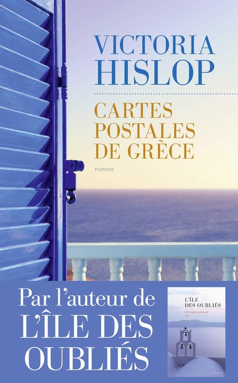
Hislop Victoria Delarbre Alice Kakolyris Alexandros
Cartes postales de Grèce
LES ESCALES 2017 433 pages 14 2x22 3x3 9cm. 2017. Broché. 433 pages.
Riferimento per il libraio : 500034596
|
|
|
Historical Maps
View of San Francisco
Ithaca: Historical Maps 1968. 60x84 cm. Color poster. Very Good. In plastic.Item in plastic sleeve new photos of item can be sent to customer upon request. Ithaca: Historical Maps, 1968 unknown
Riferimento per il libraio : 73-3802
|
|
|
Hitti, Philip K. (Philip Khuri), 1886-1978. ; maps, Joseph P. Ascherl
Makers of Arab history. Religious and political. Muhammad : triple initiator of religion nation and state -- 'Umar Ibn-al-Khattab : founder of the Moslem empire -- Mu'awiyah : architect of the Arab empire -- 'Abd-al-Rahman I : maker of history on European soil -- Al-Ma'mun : radical caliph and intellectual awakener of Islam -- 'Ubaydullah al-Mahdi : founder of the Fatimid empire in Africa -- Salah-al-Din : hero of the anti-crusades -- pt. 2: Intellectual. Al-Ghazzali : greatest theologian of Islam -- Al-Shafi'i : founder of the science of Islamic law -- Al-Kindi : philosopher of the Arabs -- Ibn-Sina : prince of physicians and philosophers -- Ibn-Rushd : the great commentator -- Ibn-Khaldun : first philosopher of history
New York Harper & Row 1971 1971. Book. Very Good. Soft cover. 268 p. maps. 20 cm. ; ISBN: 0061315486 pbk.; 9780061315480 pbk. ; Harper torchbooks ; stiff paper wrappers ; label on back cover ; TB1548; OCLC: 830405 ; LC: D198.3; Dewey: 909.0976 ; originally published by St. Martin's Press in 1968 ; ".provides in-depth profiles of thirteen prominent figures of Islamic history. These eminent Muslims from Mohammed PBHN to Ibn Khaldun are presented in sketches that personify these outstanding men and profiling them as products of their respective times rather than merely chronicling their achievements." ; Contents: pt. 1: Religious and political. Muhammad : triple initiator of religion nation and state -- 'Umar Ibn-al-Khattab : founder of the Moslem empire -- Mu'awiyah : architect of the Arab empire -- 'Abd-al-Rahman I : maker of history on European soil -- Al-Ma'mun : radical caliph and intellectual awakener of Islam -- 'Ubaydullah al-Mahdi : founder of the Fatimid empire in Africa -- Salah-al-Din : hero of the anti-crusades -- pt. 2: Intellectual. Al-Ghazzali : greatest theologian of Islam -- Al-Shafi'i : founder of the science of Islamic law -- Al-Kindi : philosopher of the Arabs -- Ibn-Sina : prince of physicians and philosophers -- Ibn-Rushd : the great commentator -- Ibn-Khaldun : first philosopher of history. ; Philip K. Hitti was educated at the American University of Beirut and at Columbia University in New York. He received his Ph.D. in history from Columbia in 1915 two years after he had settled in the United States. In 1925 following a number of years of teaching at Columbia and at American University of Beirut he accepted an appointment at Princeton University where he remained until his retirement in 1954. He became the first director of Princeton's Near Eastern Studies Program. Hitti translated wrote and lectured extensively about the Arab world and Islamic civilization. A leading authority in the United States on Arabic and Islamic studies he promoted and popularized Arabic studies in American educational institutions for nearly half a century. His most famous work is History of the Arabs published in 1937 today considered a standard in the field. ; VG. New York, Harper & Row, 1971 Paperback
Riferimento per il libraio : 006345 ISBN : 0061315486 9780061315480

|
|
|
Hobbs, J. S.
Maps and Regions : An Introductory Course Volume One
Ex-library copy with usual marks and stamps. No creasing to covers or to spine. A very clean very tight copy with bright unmarked boards, front end paper missing and no bumping to corners. 143pp. An introduction to maps and regions.

|
|
|
HOCHMAN (Gene)
Encyclopedia of American Playing Cards. Part I. (un volume). Supplement to part I. (un volume). Part II. Featuring transformation cards and insert cards. (un volume). Part III. Featuring advertising, new suit signs, oddities, no revoke cards, teaching cards, novelties, college cards, union cards, fortune telling, tarots, price guide. (un volume). Part IV. Featuring standard cards through the years. (un volume). Part V. Complete index. (un volume). Part VI. Congratulations to the U.S. Playing Card Co. on their Centennial Year 1881-1981. (un volume).
chez l'auteur, 1976-1977-1979-1980-1982 0 7 volumes in-4°, (1) 55 ff., (10) ff., (2) 67 ff., (2) 74 ff., (2) 94 ff., 33 pp. et 42 pp., couvertures illustrées, dos collé pour 4 tomes, dos agrafé pour 3 tomes. (coupures en bordure de la couverture au tome I, deux couvertures décolorées). Nombreuses illustrations en noir & blanc dans le texte. Signature de l'auteur sur le tome VI. Exemplaire ronéoté. Ouvrage de référence sur les cartes à jouer. Rare complet.
Riferimento per il libraio : 023809
|
|
|
HOCQUART Edouard-Auguste
Règles du jeu de bésigue à 2, 3 et 4 joueurs, et à 1, 2, 3 ou 4 jeux de cartes ; par M. X ...
Paris Théodore Moronval s.d. [vers1840] in-18 cart. moderne de papier brique, dos lisse, pièce de titre en long
Riferimento per il libraio : 24871
|
|
|
Hochstrasser, Monique
The Art of the Regent
102 pages. A sumptuously presented selection of the art collection displayed in The Regent in Hong Kong. This is a collection carefully acquired not only for its aesthetic beauty but also for the elements of oriental symbolism that are represented. Includes fine examples of skilfully executed screens, lacquerware and embroidery. There are specimens of Chinese export wallpaper, and several nineteenth-century China Trade oil paintings. These became popular as artistic records of the cultural and trading contacts of their period and are now collector's items. The selection of maps traces the pattern of adventure and romantic trade and travel over the centuries. Finally, a group of contemporary works pleasantly relate the collection to modern artistic trends. All illustrations in vivid colour photography. Attractive maroon cloth boards bear imprint of Chinese characters upon front board and gilt roman lettering upon spine. Illustrated slipcase shows light edgewear and several nicks. Book and slipcase bear the aroma of moth balls. Book
|
|
|
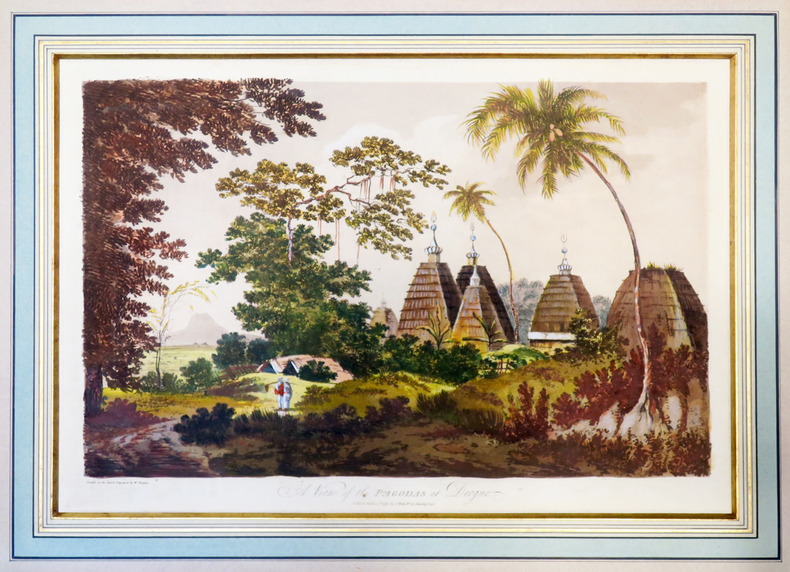
HODGES (William).
A View of the pagodas at Deogur.
1787. 313 x 453 mm, sous passe-partout.
Riferimento per il libraio : LBW-4002
|
|
|
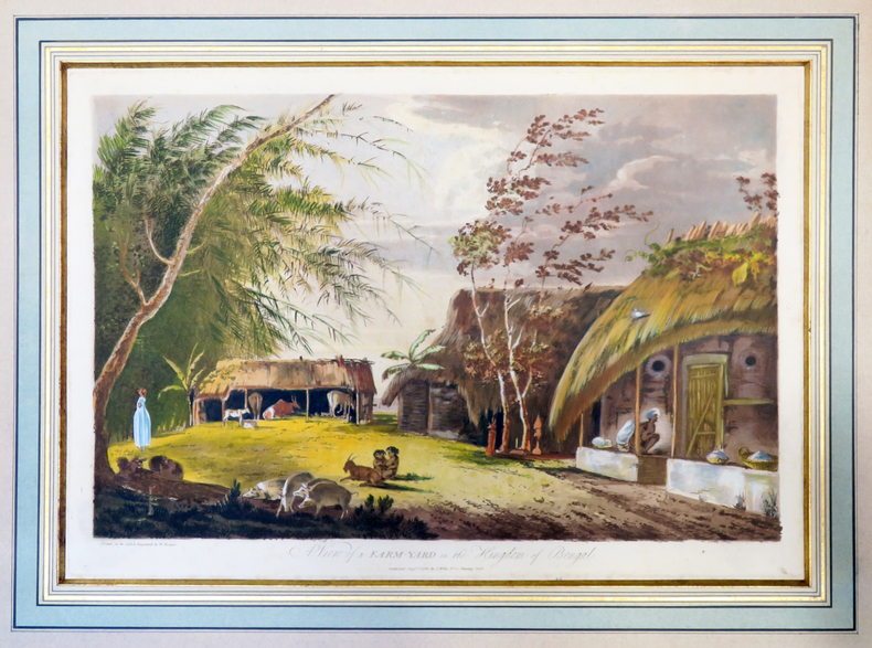
HODGES (William).
A View of a farm-yard in the kingdom of Bengal.
1787. 312 x 452 mm, sous passe-partout.
Riferimento per il libraio : LBW-4003
|
|
|
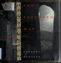
Hodgson, Barbara
The Tattooed Map
Vancouver BC: Raincoast Books 1995 Book. New. Hardcover. 1st Canadian Edition. A traveler to North Africa discovers that the mysterious marks on her hand have developed into a detailed and macabre maps spreading across her skin. We follow Lydia's journal entries as she becomes increasingly drawn into the mystery of the map traced over her body. When she disapears and her travelling partner Christopher takes up her journal the situation becomes even more puzzling - until the book's bizaare resolution. Profusely illustrated with ephemera documents maps pictures postcards to illuminate the story. Raincoast Books hardcover
Riferimento per il libraio : 042711 ISBN : 1895714915 9781895714913
|
|
|
HOFFBAUER (Fédor).
La Cité entre le Pont Notre-Dame et le Pont au Change (1621).
Paris, Firmin-Didot et Cie, [1875-1882]. 237 x 300 mm.
Riferimento per il libraio : LBW-5818

|
|
|
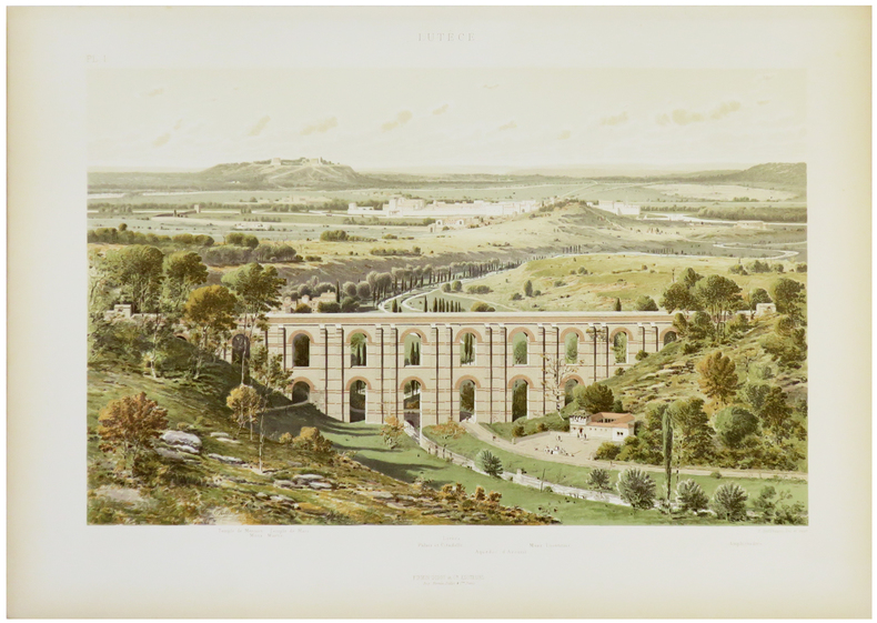
HOFFBAUER (Fédor).
Lutèce.
Paris, Firmin-Didot et Cie, [1875-1882]. 284 x 369 mm.
Riferimento per il libraio : LBW-5821
|
|
|
Hoffman, Ludmila W.
Old Scapes, New Maps - A Training Program for Psychotherapy Supervisors
223 pages including two indeces. Author continues the pursuit of her long standing interest in the education and training of professional psychologists. A valuable resource for instructors of graduate programs in Psychology, Social Work, Psychiatric Nursing, Psychiatry and Counseling. Clean, crisp and unmarked with negligible wear. Excellent copy. Book
|
|
|
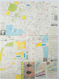
HOFFMAN, WALTER K. (CARTOGRAPHER).
A-O-A Map Sheet: Orientation Mini-maps.
Hong Kong.: Walter K. Hoffman. January/February1976. Coloured tourist map brochure of maps of Hong Kong printed both sides six maps in total folded. Brochure also includes advertisements currency rates. Minor tears along folds otherwise in good condition. Text in traditional Chinese English and Japanese. Sheet measures 58.2 x 43.4cm. Sheet includes 6 individual maps: Map of British Crown Colony of Hong Kong Map of the Urban Area with routes for public transportation Map of Tsimshatsui large scale street map Map of Central District large scale street map Map of Wanchai large scale street map Map of Causeway Bay large scale street map Map of Portuguese Overseas Province of Macau. On the maps of Central and TST the names of many businesses hotels etc are marked. . Walter K. Hoffman. unknown
Riferimento per il libraio : 161881
|
|
|
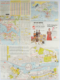
HOFFMAN, WALTER K. (CARTOGRAPHER).
A-O-A Map Sheet: Orientation Mini-maps.
Hong Kong.: A-O-A Ltd. June/July1977. Coloured tourist maps of Hong Kong printed both sides on a sheet folded. One general area map of Hong Kong and three detailed street maps featuring Kowloon Peninsula Tsimshatsui and Central District. Generally in very good condition text in traditional Chinese English and Japanese. Sheet measures 58.2 x 43cm. The tourist maps include currency rate tourist advice advertisements for foreign and local brands and shops e.g. A-O-A Gambling Handbook for Macau Duty Free shopping centres Chinese Arts & Crafts centres acupuncture clinic etc. The maps of Central and TST have the names of many hotels businesses post offices etc marked on them. . A-O-A Ltd. unknown
Riferimento per il libraio : 161880
|
|
|
Hoffmann, Georg
2 Panoramen des Maderaner-Thales im Kanton Uri. Dazu ein Führer in die Gebirge des Maderaner-Thales. Verfasst von einigen Mitgliedern der Basler Section des schweizerischen Alpenclubs.
Basel, Felix Schneider, 1865. Textheft 54 S. u. 2 lithogr. Panoramen. 43 x 129 cm. + Wichtig: Für unsere Kunden in der EU erfolgt der Versand alle 14 Tage verzollt ab Deutschland / Postbank-Konto in Deutschland vorhanden +
Riferimento per il libraio : 234BG
|
|
|
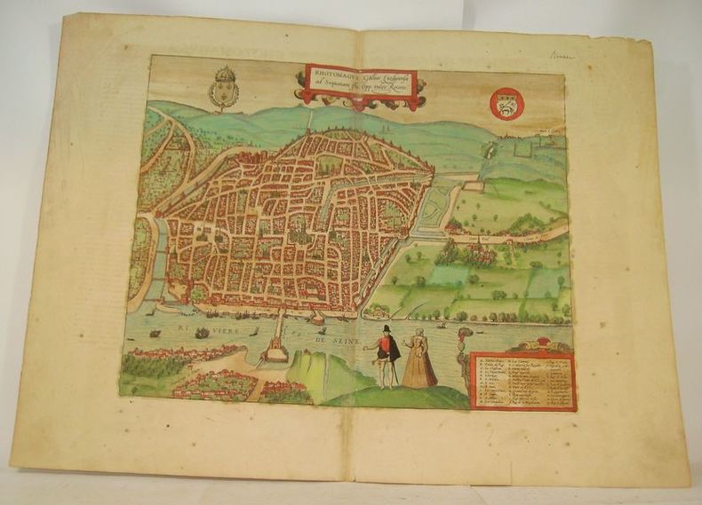
HOGENBERG (Franz).
RHOTOMAGUS Galliae Lugdunensis ad Sequanam Flu. Opp. vulgo Rouen.
Cologne, circa 1590. Gravure à belles marges (40 x 54 cm), rehaussée en couleurs avec texte en latin au dos.
Riferimento per il libraio : 16633
|
|
|
Hogarth David George; Bartholomew J. G. maps
THE PENETRATION OF ARABIA
New York: Frederick A. Stokes Company 1904. First American Edition. Hardcover. Octavo xiii 359 pages; VG-; bound in publisher's decorated green cloth gilt and black titling to spine; mild wear and rubbing primarily to head of spine and corners; bookplate to ffep; with 54 maps and plates; scarce; LJ consignment; shelved case 8 1/2. Also published in London the same year.;. 1336482. Shelved Dupont Bookstore. Frederick A. Stokes Company hardcover books
Riferimento per il libraio : 1336482

|
|
|
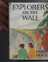
Hogg, Garry & Haigh, Molly (Illus) Tony (Add. Sketches & Maps)
Explorers on the Wall
London: Nelson. Very Good in Good dust jacket. 1948. Second Printing. Hardcover. A scarce title in the Explorers Awheel Series with an extremely scarce dustwrapper. The book is in green cloth boards with white lettering to spine. Maps to endpapers. A prize presentation inscription on blank endpaper ; The Explorers; 8vo 8" - 9" tall . Nelson, hardcover
Riferimento per il libraio : 100515
|
|
|
Hohkirchen:
Hohkirchen. "Plan der Bataille, welche d. 14.October 1758 von der Kayserl. Königl. Ungarischen und Kön. Preussischen Armee bei Hohkirchen ohnweit Bauzen geliefert worden." Schlachtenplan von Hohkirchen. Kupferstich mit farbigen Truppenaufstellungen, Legende rechts. der Abbildung aus "Neues Kriegs-Theater", No. 20.
Format: 18 x 29,5 cm. *Leicht gebräunt, insgesamt gut erhalten. Landkarten de
|
|
|
HOLLIER (Antoine Grégoire).
[CRIMÉE/MER d'AZOV] Vue générale de la mer d'Azoff & du détroit de Kertch.
Paris, Hollier, [circa 1856]. 236 x 282 mm.
Riferimento per il libraio : LBW-6517

|
|
|
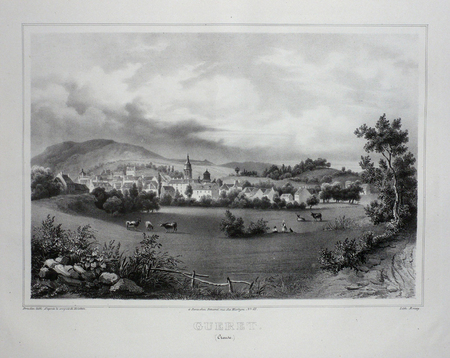
HOLSTEIN;
GUERET (Creuse).
Paris Benard circa 1850 226 x 287 mm.
Riferimento per il libraio : LBW03d65
|
|
|
HOLSTEN - MERCATOR, G. / HONDIUS.
Holsatia ducatus. Per Gerardum Mercatorum privilegio.
(Amsterdam ca. 1607). 35,3x48 cm. Kobberstukket kort over Holsten. Ukoloreret. Velbevaret. På bagsiden latisnk tekst (pp.89-90) Daniae III Tabula, In qua Slesvicensis Ducatus, & Holsatia.
Riferimento per il libraio : 25258
|
|
|
HOLDER, Eric
Nouvelles du Nord
1984 - broché - Editions Le Dilettante - 1984 - In-12 (18 x 12 cm) broché avec agrafes, couverture à rabats - 23 pages - Avec une carte volante (plan Taride) du Xe arrondissement, possiblement signée par Eric Holder - Plaquette tirée à 333 exemplaires, sans justificatifs de tirage
Riferimento per il libraio : 614

|
|
|
Holborn Hajo; Maps Illustrator
History of Modern Germany: 1840-1945 v. 3
Alfred A Knopf 1969-01-01. Hardcover. Good. Hardcover and dust jacket. Good binding and cover. Underlining. DJ torn along spine. Bookplate. Alfred A Knopf hardcover
Riferimento per il libraio : 2104200009 ISBN : 0413277003 9780413277008
|
|
|
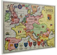
Holmes, Sherlock; Wolff, Dr. Julian [Maps]
THE SHERLOCK HOLMES MAP OF EUROPE: Greeting Card No. 4
London: Moore Batley Limited printer 1961. Single fold card with coloured map by Julian Wolff introductory commentary by Lord Donegall Christmas/New Year greeting and 'An incomplete gazetteer'. 16.2 cm. x 20.3 cm.; within blank envelope edges lightly chipped and browned; Moore Batley Limited printer London 1961. De Waal World Bibliography #4820. 'Julian Wolff who became head of the Baker Street Irregulars in 1960 created an attractive and imaginative series of canonical locations some of which originally appeared in Edgar W. Smith's 'Baker Street and Beyond' other in 'The Baker Street Journal'. In 1984 they were collected and printed as 'The Sherlockian Atlas'. They depict London England Europe the United States Dartmoor and other significant sites including a layout of the interior of 221B Baker Street. In the 1960s Wolff also hand-coloured a set for Lord Donegall editor of 'The Sherlock Holmes Journal' who had them printed as Christmas Cards. These cards are now highly collectible as are the original maps.' The Sherlock Holmes Miscellany Roger Johnson Jean Upton. Moore Batley Limited (printer) unknown
Riferimento per il libraio : 089419
|
|
|
Holmes, Sherlock; Wolff, Dr. Julian [Maps]
THE SHERLOCK HOLMES MAP OF ENGLAND: Greeting Card No. 7
London: Graphis Press Limited printer 1964. Single fold card with coloured map by Julian Wolff introductory commentary by Lord Donegall Christmas/New Year greeting and 'An incomplete gazetteer'. 16.2 cm. x 20.3 cm.; within blank envelope edges lightly chipped and browned; Graphis Press Limited printer London 1964. De Waal World Bibliography #4820. 'Julian Wolff who became head of the Baker Street Irregulars in 1960 created an attractive and imaginative series of canonical locations some of which originally appeared in Edgar W. Smith's 'Baker Street and Beyond' other in 'The Baker Street Journal'. In 1984 they were collected and printed as 'The Sherlockian Atlas'. They depict London England Europe the United States Dartmoor and other significant sites including a layout of the interior of 221B Baker Street. In the 1960s Wolff also hand-coloured a set for Lord Donegall editor of 'The Sherlock Holmes Journal' who had them printed as Christmas Cards. These cards are now highly collectible as are the original maps.' The Sherlock Holmes Miscellany Roger Johnson Jean Upton. Graphis Press Limited (printer) unknown
Riferimento per il libraio : 141900
|
|
|
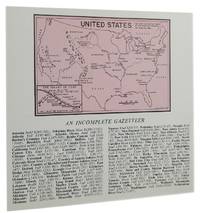
Holmes, Sherlock; Wolff, Dr. Julian [Maps]
THE SHERLOCK HOLMES MAP OF THE UNITED STATES: Greeting Card No. 9
London: N 1966. Double fold card with coloured illustration across inside panels 'Operation House-moving from Baker Street to Chateau de Lucens Switzerland' with key to contents commentary by Lord Donegall brief "The compliments of the season" The Blue Carbuncle message and a smaller map of the United Stated by Julian Wolff above 'An incomplete gazetteer'; 14.9 cm. x 15.9 cm.; within large blank envelope edges lightly browned; London 1967. De Waal World Bibliography #4820. 'Julian Wolff who became head of the Baker Street Irregulars in 1960 created an attractive and imaginative series of canonical locations some of which originally appeared in Edgar W. Smith's 'Baker Street and Beyond' other in 'The Baker Street Journal'. In 1984 they were collected and printed as 'The Sherlockian Atlas'. They depict London England Europe the United States Dartmoor and other significant sites including a layout of the interior of 221B Baker Street. In the 1960s Wolff also hand-coloured a set for Lord Donegall editor of 'The Sherlock Holmes Journal' who had them printed as Christmas Cards. These cards are now highly collectible as are the original maps.' The Sherlock Holmes Miscellany Roger Johnson Jean Upton. N unknown
Riferimento per il libraio : 141901
|
|
|
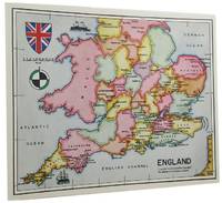
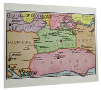
Holmes, Sherlock; Wolff, Dr. Julian [Maps]
THE SHERLOCK HOLMES MAP OF ENGLISH COUNTIES: Greeting Card No. 10
London: Graphis Press Limited printer 1967. Single fold card with coloured map by Julian Wolff 'It is full of old houses' introductory commentary by Lord Donegall Christmas/New Year greeting and 'An incomplete gazetteer'; 16.2 cm. x 20.3 cm.; within blank envelope lightly browned top and bottom edges chipped; Graphis Press Limited printer London 1967. De Waal World Bibliography #4820. 'Julian Wolff who became head of the Baker Street Irregulars in 1960 created an attractive and imaginative series of canonical locations some of which originally appeared in Edgar W. Smith's 'Baker Street and Beyond' other in 'The Baker Street Journal'. In 1984 they were collected and printed as 'The Sherlockian Atlas'. They depict London England Europe the United States Dartmoor and other significant sites including a layout of the interior of 221B Baker Street. In the 1960s Wolff also hand-coloured a set for Lord Donegall editor of 'The Sherlock Holmes Journal' who had them printed as Christmas Cards. These cards are now highly collectible as are the original maps.' The Sherlock Holmes Miscellany Roger Johnson Jean Upton. Graphis Press Limited (printer) unknown
Riferimento per il libraio : 141902
|
|
|
Holstein
[Karte von] Herzogth. Holstein und Lauenburg, Fürstenth. Lübeck, Fr. Städte Hamburg und Lübeck nebst Amt Bergedorf. Grenzkolorierter Stahlstich, gestoch. von K. Fuchs.
Hildburghausen, Bibliographisches Institut, [ca. 1865]. Bildgröße: 31 x 38 cm. Im Mahagonirahmen, unter Mattglas (38,5 x 47 cm).
Riferimento per il libraio : 97900

|
|
|
HOLSTEN - MERCATOR, G. / HONDIUS.
Holsatia ducatus. Per Gerardum Mercatorum privilegio.
(Amsterdam ca. 1607). 35,3x48 cm. Kobberstukket kort over Holsten. Ukoloreret. Velbevaret. På bagsiden latisnk tekst (pp.89-90) Daniae III Tabula, In qua Slesvicensis Ducatus, & Holsatia.
|
|
|
Holzer - Reilly, Franz Johann Joseph von
Special-Karte von dem Oestreichischen u. Osmanischen Koenigreiche Kroatien. Teilkolorierte Kupferstichkarte (No. 2) aus "Schauplatz der fünf Theile der Welt".
Wien, Reilly, ca. 1789. 22 x 29 cm (Blattgröße 24 x 32 cm).
Riferimento per il libraio : 110616

|
|
|
Holzman, Jacquelin; McQuarrie, John; Tosh, Rosalind
Ottawa, Then and Now
No marks or inscriptions. A lovely clean very tight copy with bright unmarked boards and no bumping to corners. Dust jacket not price clipped or marked or torn with slight creasing to edges and traces of storage. 208pp. Ottawa from her birth to the present day in very well captioned photographs. Scarce in the UK.

|
|
|
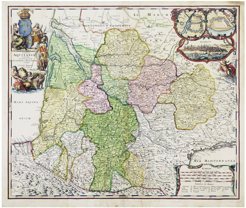
HOMANN (Johann Baptist).
[AQUITAINE] Tabula Aquitaniæ complectens gubernationem Guiennæ et Vasconiæ exhibita.
Nuremberg, [circa 1720]. 478 x 570 mm.
Riferimento per il libraio : LBW-6109
|
|
|
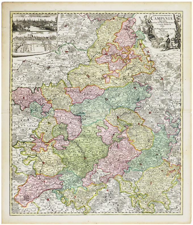
HOMANN (Johann Baptist).
[CHAMPAGNE] Tabula geographica specialis in suas sic dictas electiones accurate distincta edita.
Nuremberg, [circa 1720]. 574 x 488 mm.
Riferimento per il libraio : LBW-6259
|
|
|
HOMANN (Héritiers de);
[CROATIE/BOSNIE/SERBIE] Regnum Bosniae, una cum finitimis Croatiae, Dalmatiae, Slavoniae, Hung. et Serviae partibus - Regni Serviae pars, una cum finitimis Valachiae & Bulgariae.
Nuremberg vers 1740 En 4 feuilles jointes de 605 mm x 1,11 m, dont une partie mobile de 310 x 185 mm.
Riferimento per il libraio : LBW-1799

|
|
|
HOMANN (Johann Baptist);
[METZ] Accurata rapraesentatio ichnographica urbis episcopalis in Ducatu Lotharingiae, dictae Metae.
Nuremberg 1739 470 x 556 mm.
Riferimento per il libraio : LBW-403

|
|
|
HOMANN (Johann Baptist).
[PAVILLONS] Flaggen aller Seefahrenden Potenzen und Nationen in der gantzen Weldt.
Nuremberg, [circa 1720]. 495 x 587 mm.
Riferimento per il libraio : LBW-4462

|
|
|
HOMANN (Héritiers de).
[PANAMA] Portus Pulchri in Isthmo Panamensi - Scenographia Portus Pulchri.
[Nuremberg], Homann Héritiers, 1740. 480 x 282 mm.
Riferimento per il libraio : LBW-5884

|
|
|
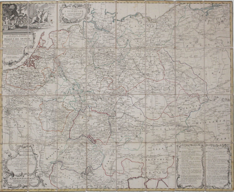
HOMANN (Héritiers de).
[POSTES] Nouvelle carte géographique des postes d'Allemagne - Neue und vollstændige Postkarte durch ganz Deutschland.
Nuremberg, Héritiers de Homann, 1786. En 32 sections montées sur toile et pliées, formant une carte de 776 x 968 mm.
Riferimento per il libraio : LBW-4318
|
|
 Ricevere i risultati per e-mail
 Scaricare i risultati in PDF
 RSS feed


