|
Eby, Ezra E. (1895-96), Joseph B. Snyder (1931); Eldon D. Weber (index, notes, maps and documents)
A Biographical History of Early Settlers and Their Descendants in Waterloo Township
Waterloo Canada: Eldon D. Weber 1984. hardcover. Good. 0x0x0. Fair brown cloth hardcover has fraying to spine ends and edges and 3x2" and a 1x2" pieces if cloth missing from the spine exposing the cardboard underneath gift inscription on front endpage binding sound internally clean. copyright page has the address for Eldon Weber crossed out and a new address stamped below it. Includes an index and a map enclosed in an envelope affixed to the rear inside cover. Includes a supplement by Joseph B. Snyder. 1984 reprint ISBN 0919061001. Not a print on demand copy. Around 1800 families of Mennonites began to move north from the United States to Canada in search of farm land. Ezra Eby collected family histories from Pennsylvania German pioneer families in Waterloo Township Ontario and originally published these as "A Biographical History of Waterloo Township" in 1895 and 1896. Eldon D. Weber hardcover
Bookseller reference : 250713001 ISBN : 0919061001 9780919061002
|
|
|
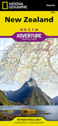
National Geographic Maps - Adventure
New Zealand Map National Geographic Adventure Map 3500
map. Good. Access codes and supplements are not guaranteed with used items. May be an ex-library book. unknown
Bookseller reference : 1566955491.G ISBN : 1566955491 9781566955492
|
|
|
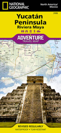
National Geographic Maps - Adventure
Yucatan Peninsula: Riviera Maya Map Mexico National Geographic Adventure Map 3105
map. Good. Access codes and supplements are not guaranteed with used items. May be an ex-library book. unknown
Bookseller reference : 156695245X.G ISBN : 156695245X 9781566952453
|
|
|
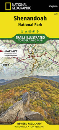
National Geographic Maps Trails Illustrated
Shenandoah National Park Map National Geographic Trails Illustrated Map 228
map. Good. Access codes and supplements are not guaranteed with used items. May be an ex-library book. unknown
Bookseller reference : 1566953650.G ISBN : 1566953650 9781566953658
|
|
|
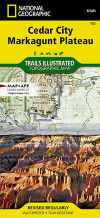
National Geographic Maps - Trails Illustrated
Cedar City Markagunt Plateau Map National Geographic Trails Illustrated Map 702
map. Good. Access codes and supplements are not guaranteed with used items. May be an ex-library book. unknown
Bookseller reference : 1566953065.G ISBN : 1566953065 9781566953061
|
|
|
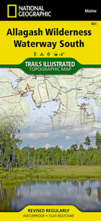
National Geographic Maps - Trails Illustrated
Allagash Wilderness Waterway South Map National Geographic Trails Illustrated Map 401
map. Good. Access codes and supplements are not guaranteed with used items. May be an ex-library book. unknown
Bookseller reference : 1566955874.G ISBN : 1566955874 9781566955874
|
|
|
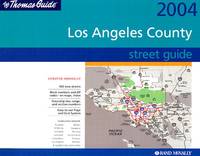
Thomas Bros Maps
Thomas Guide 2004 Los Angeles County Street Guide
paperback. Good. Access codes and supplements are not guaranteed with used items. May be an ex-library book. paperback
Bookseller reference : 052899932X.G ISBN : 052899932X 9780528999321
|
|
|
Catton Bruce; Illus. with Maps
Never Call Retreat: Volume Three in the American Civil War Trilogy
Fall River Press 2009. Fall River Press 2009 First Edition NL with 1 Near Fine/ Faint spine crease o/w Fine. Includes 12 glossy map photo pages. xvi12555 pages with index. HEAVY ITEM 1.75 Pounds. Size: 9 1/4 x 6 x 1 5/8 inches. First Edition NL with 1. Paperback. Near Fine. No Exp. Fall River Press Paperback
Bookseller reference : 369547
|
|
|
National Geographic Maps - Trails Illustrated (Corporate Author)
National Geographic Topographic Map Guide Appalachian Trail Virginia: Damascus to Bailey Gap
Natl Geographic Maps 2015. Map. New. fol map edition. 44 pages. 9.10x4.10x0.10 inches. Natl Geographic Maps unknown
Bookseller reference : 2-1597756407 ISBN : 1597756407 9781597756402

|
|
|
Cartes Montory, Armando
FRANCESES EN EL PAÃS DEL BÃO-BÃO : 1550-1850
Chile: The Author 2004. First edition. Paperback. Fine. 259p. photos illus. wrps. The Author paperback
Bookseller reference : 187899
|
|
|
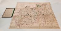
(Walker's County Maps)
Walker's Surrey Folding hand coloured linen backed map measuring 410x350mm
London: Longman Rees and Co. Very Good. 1846. Map. Small chip to spine of cloth case. Original paper title label chipped . Longman, Rees, and Co unknown
Bookseller reference : B4799
|
|
|
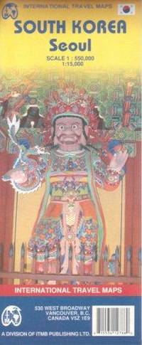
International Travel Maps
South Korea & Seoul Travel Reference Map English and Korean Edition
map. Good. Access codes and supplements are not guaranteed with used items. May be an ex-library book. unknown
Bookseller reference : 1553412788.G ISBN : 1553412788 9781553412786
|
|
|
Kingsolver, Barbara, Cartes, Rebecca, Seal Press Staff
Another America : Otra America
Basic Books. Used - Very Good. Used book that is in excellent condition. May show signs of wear or have minor defects. Basic Books unknown
Bookseller reference : 4294988-6 ISBN : 1580050042 9781580050043

|
|
|
Maps, National Geographic
The Ultimate Hiker's Gear Guide : Tools and Techniques to Hit the Trail
National Geographic Society. Used - Very Good. Former library book; may include library markings. Used book that is in excellent condition. May show signs of wear or have minor defects. National Geographic Society unknown
Bookseller reference : 9306781-6 ISBN : 1426209207 9781426209208

|
|
|
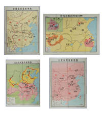
FOUR MAPS OF CHINESE DYNASTIES.
Four Chinese Educational Dynasty Maps: Liao Bei Song Xi Xia Situation Map; Jin Nan Song Xi Xia Situation Map; Major Peasant Rebellions During the Song Dynasty Map; Peasant Battles in the Late Yuan Dynasty Situation Map.
Shanghai.: 地图出版社 Cartographic Publishing House. Four coloured folding maps in the High School Chinese History Teaching Maps series. <br>Map 1 辽北宋西夏形势图 Liao Bei Song Xi Xia Situation Map 106 x 75.6cm <br>Map 2 金南宋西夏形势图 Jin Nan Song Xi Xia Situation Map 106 x 75.6cm <br>Map 3 宋代主要农民起义图 Major Peasant Rebellions During the Song Dynasty Map 76.5 x 106cm <br>Map 4 元末农民战争形势图 Peasant Battles in the Late Yuan Dynasty Situation Map 106 x 76.5. <br>Text in simplified Chinese characters. Some very slight browning at folds on reverse not affecting image or text minor soiling at edges else all in very good bright condition. Descriptive listing in Chinese also included. Map 1 辽北宋西夏形势图 shows the Liao regime established by the Khitan in the north the western Xia established by the Danxiang in the northwest which co-existed with the Northern Song. Important military and economic activity locations also shown. <br>Map 2 金南宋西夏形势图 shows the situation during the Southern Song Dynasty when three regimes co-existed; the Jin established by the Jurchens in the northeast the Western Xia established by the Dangxiang in the northwest and the Southern song. Important military activity locations also shown. <br>Map 3 宋代主要农民起义图 shows locations of peasant uprisings in the Northern and Southern Song Dynasties <br>Map 4 元末农民战争形势图 shows the situation of the three northern expeditions of the Red Turban Rebellion at the end of the Yuan Dynasty and the activities of the rebel armies. . 地图出版社 [Cartographic Publishing House]. unknown
Bookseller reference : 217061
|
|
|
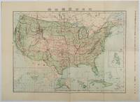
[ANACHRONISTIC MAP OF THE UNITED STATES INCLUDING CUBA AS A TERRITORY].
北米合衆国全図. Hokubei Gasshūkoku zenzu. Map of the United States of America.
Tokyo.: 楠山正雄. Kusuyama Masao. Meiji 44 1911. Colour folding map 40 x 55cm inset maps showing the Philippines Alaska and Hawaii very good copy. This map was a supplement of October 1911 issue of a monthly magazine Shin Nippon 新日本 which was published between 1911 and 1918. The main map covers the contiguous United States with inset maps of the world showing the American territories of Alaska Hawaii and the Philippines. Curiously Cuba has been marked as an American territory having been directly occupied from 1906 to 1909 though at the time still beholden to the 1903 Cuban-American Treaty of Relations. . 楠山正雄. [Kusuyama Masao]. unknown
Bookseller reference : 179415
|
|
|
[ISHIBASHI GORO, GENERAL EDITOR]. 石橋五郎監修.
世界現勢解説地圖. Sekai Gensei Kaisetsu Chizu. Explanatory Maps of the Present State of the World.
大阪朝日新聞社. Osaka Asahi Shinbunsha. Showa 12 1937. 10 colour maps not including insets or sketch maps in text on 12 pages. Handsome world map features as the centre fold colour pictorial paper wrappers. A little light soiling and horizontal crease wrappers. An attractive atlas. 38 x 26.7cm. A large format atlas with six pages of coloured maps showing the nations of the world and five pages of Japanese text. The publication seems to have been produced to celebrate the 1937 world record flight from Tokyo to London by Iinuma Masaaki and Tsugayoshi Kenji in their plane 'Kamikaze' which was sponsored by the Asahi Newspaper. The front cover depicts the plane soaring over a map of the world while the back cover also had a colour image of the 'Kamikaze' with an advertisement for the Oji Paper Company which we are told donated a hundred million yen to support the flight. The name 'Kamikaze" had at that stage not yet taken on the connotations which it acquired during the Pacific War. <br> <br>The maps inside the volume show political boundaries major cities and transport routes. The opening pages show the Japanese Empire including Japan proper Korea Karufuto and Manchukuo with small insets covering Taiwan the Chishima Archipelago and Japan's South Sea mandate. The accompanying text focuses on Japan's newly acquired client state of Manchukuo detailing its area population principle products etc while the map includes graphs illustrating Japan's trade with the world and with Manchukuo. China receives an entry of its own with a map of the Chinese Republic and information on the political situation population trade and infrastructure. The central pages of the volume are taken up with a double-spread map of the world including depictions of the flags of a selection of the world's nations. Other sections of the work cover Asia Europe America Africa and Oceania grouped together. The discussion of Oceania includes a section on Hawaii and some small and improbable depictions of Maori and Indigenous Australians. . 大阪朝日新聞社. [Osaka Asahi Shinbunsha]. unknown
Bookseller reference : 208633

|
|
|
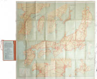
[1920S TOURIST MAP - JAPAN, KOREA AND TAIWAN].
Travelers' Map of Japan Chosen Korea Taiwan Formosa with Brief Descriptions of the Principal Tourist Points in Japan. 1927.
Tokyo.: Japanese Government Railways. Circa1927. Large folding colour map 78.5 x 80 cm of Japan and Korea 6 inset maps one of which shows Taiwan scale 1:1640000 for Hondo Shikoku and Kyushu 1:2340000 for Chosen; tipped into the original orange cloth covered case with orange ties text in 31 panels on the verso one a little age-toned a few very small fold splits without loss a very good copy. Attractive tourist map for the English-speaking traveller issued by the Japanese Government Railways with extensive notes for tours and points of interest on the verso short descriptions of cities and sites to visit principal theatres with suggestions for cafes restaurants and department stores. . Japanese Government Railways. hardcover
Bookseller reference : 215711
|
|
|
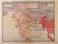
WORLD WAR II MAP BURKE HOWARD; CAB. C. A.
Jap Drive into India perils entire Allied strategy in Pacific
Los Angeles.: Los Angeles Examiner. April 31944. Colour pictorial map on a single newspaper leaf 37 x 50 cms; 41.5 x 54.6 cms sheet unrelated text on the verso although with an interesting account from a soldier's letter about an air raid in China toning more marked at the central fold two small splits no loss to the map edge wear with several small marginal edge tears neatly repaired on the verso with archival washi map unaffected in good condition. A dynamic map prepared and illustrated by the Examiner's art critic and editor Howard Burke covering the area surrounding India and Central Asia showing Japanese conquered territory in Malaya Thailand Indo-China and Burma; and in India British-controlled states and native feudal and protected states. <br> <br>Text boxes and pictographs give an overview of the geopolitical situation from the Allied perspective. One box notes "Chanda Bose has many adherents and fanatical followers in Bengal. They may prove to be a powerful fifth column in India". Text at lower edge opines "The situation in India is critical and has grown more so as the all-out offensive against Japan has been delayed. If the Allies do not act at once and with great force all our gains may be wiped out and the war in the Pacific prolonged indefinitely." <br> <br>The decisive and devastating bombings that were to signal such an end were four months away. <br> <br>Rare on the market. . Los Angeles Examiner. unknown
Bookseller reference : 214362
|
|
|
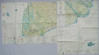
[MEKONG DELTA - VIETNAM WAR MAPS]
Khanh Hu'ng and Quan Long Vietnam. Series 1501 AIR. Sheets NC 48-10 & 11. Edition 2.
Washington D.C.: Army Map Service. 1967. Two printed colour adjoining maps 73 x 55.6 cms and 55.6 x 73 cms original folds inked operational annotations to the Quan Long sheet multiple marginal legends noting aerodromes and radio facilities roads railroads and boundaries glossary of terms much of the text is in both English and Vietnamese in very good condition. Detailed U. S. Army maps of the Mekong Delta and Southern Vietnam extending from Rach Gia in the north to the area just south of Quan Long Ca Mau in the south and east including BacLieu and CanTho. The island of Con son is at lower right of the Khanh Hu'ng sheet. Operational notes are inked around Quan Long are marked and the U Minh Forest the impenetrable "forest of darkness" is noted in ink. <br> <br>. . Army Map Service. unknown
Bookseller reference : 203840
|
|
|
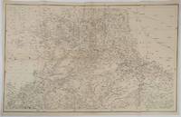
[INDIA - RAJASTHAN ANTIQUE MAP] SMITH, HM. (LITHOGRAPHER). H. M.
Rajpootana and Adjoining States Sheet No. 4.
Calcutta.: Surveyor Generals Office. 1870. Reissue of 1859 edition. Lithographed map 57.2 x 93 cms; 61.1 x 96 cms sheet original folds old paper repairs to the verso and a sealed marginal tear central folds archivally strengthened some toning to the folds and creasing but the map in remarkably good clean condition. Impressive large Calcutta printing from the Survey of India showing Rajasthan Uttar Pradesh and surrounding states with extremely detailed delineation of settlements roads railways rivers and major points of interest the Taj Mahal is highlighted. . Surveyor Generals Office. unknown
Bookseller reference : 189711
|
|
|
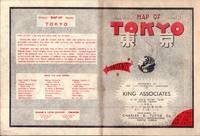
[TOKYO - TOURIST MAP] KING ASSOCIATES.
Bilingual Map of Greater Tokyo.
Tokyo.: Charles E. Tuttle Company. 1954. Printed four colour map 92 x 71cm; 102.5 x 74.5cm sheet folding into pictorial wrappers 25.6 x 19 cms inset map of the Marounouchi District and on the verso an extensive grid reference in English and Japanese and over four panels a map of the streetcar railway and subway system scant spotting to cover two small fold splits without loss and toning most evident at the folds in very good condition. Comprehensive 1950s map of Tokyo by US publisher Charles E. Tuttle "Here at last is the map that makes order out of chaos.extending as far as Haneda Airport Grant Hights Harbor Area and Nakano Ward" blurb. . Charles E. Tuttle Company. unknown
Bookseller reference : 194113
|
|
|
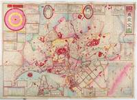
LATE 19TH CENTURY TOKYO AND YOKOHAMA MAPS
横濵市圖附市郡村名改正實測改正東京全図. Yokohamashizu tsuketari shigunsonmei kaisei jissoku kaisei Tōkyō zenzu. Map of Whole Tokyo with Yokohama City Map. Post Changes of City County and Village Names with Actual Survey.
東京. Tokyo.: 山嵜暁三郎. Yamazaki Akizaburo. Meiji 25 1892. Colour woodblock map 50 x 71cm folds into card covers with plain cloth spine. 18 x 12cm. Occasional small holes at folds some colour offsetting in places a little marking and staining along upper margin upper left section of upper cover stained with a little subsequent staining to map. A bright and attractive map which looks better than this sounds. This 1892 map of Tokyo shows a growing metropolitan city which attracts many tourists from outside. Portraits of the Emperor and the Empress are featured prominently at the top. There are 11 inset illustrations of major buildings and sites surrounding the main map with a round chart which shows directions and distances to them. Another chart lists place names in wards and counties in Tokyo. The Royal Palace is featured in the center and the palace and major buildings are coloured in red. An inset map of Yokohama sits on the lower left. . 山嵜暁三郎. [Yamazaki Akizaburo]. hardcover
Bookseller reference : 214181
|
|
|
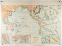
[PACIFIC - SOUTHEAST & EAST ASIA- MAP - 1930S WITH INSETS OF HONG KONG AND SINGAPORE]
Pacific Ocean. Robinsons New Map of the Pacific Ocean with Insets Showing Island Groups in Detail. Map title: Map of Pacific Ocean. Mercators Projection.
Sydney: H.E.C. Robinson. Circa1930s. Printed colour maps in all 65.5 x 99cm the main map roughly 50 x 65 cms on a single sheet 76 x 101.3 cms; a little carelessly folded decorative blue title cover a little dusty and a few fold splits and edgewear but in good condition. The exceptional feature of this map are the twenty six large scale inset maps of Pacific islands including: Malay States Singapore Hong Kong these at lower left Japan Philippine Islands Hawaiian Islands Fiji Solomon Islands Western and Eastern Samoa Tahiti Saipan New Caledonia and Dependencies and many others. <br> <br>The main map of the Pacific Ocean stretches from Southeast Asia including all of Australia and New Zealand the west coast of the Americas the Kamchatka Peninsula Manchukuo Manchuria and most of China. Korea and Taiwan are marked as Japanese Territory. Possessions of Britain France the Netherlands and the United States are highlighted. <br> <br>An incredibly rich source of information on the Pacific theatre during the years leading up to World War II. From the Sydney publisher H.E.C. Robinson the firm founded in 1895 by Herbert Robinson 1857-1933 a founder of the Royal Geographical Society of Australasia. . H.E.C. Robinson. unknown
Bookseller reference : 205997
|
|
|
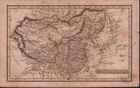
EARLY 19TH CENTURY MAP OF CHINA.
Chinese Empire.
London.: Robert Jennings. c1828. Engraved map with original hand colouring 24x 14cm vertical fold foxed and browned. Still a delightful little map. From Fenner's "Pocket Atlas of Modern & Ancient Geography" c1828. Has interesting descriptions including; Great Sandy Desert of Cobi sic called by the Chinese 'Shamo'; "Small island seen by Capt. Moore;" 'Fatsisio' place of exile for the Japanese. . (Robert Jennings) unknown
Bookseller reference : 214901
|
|
|
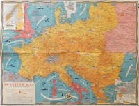
[WORLD WAR II MAP] TURNER, STANLEY (CARTOGRAPHER).
Dated Events Invasion Map of Fortress Europe.
Toronto.: C.C. Petersen. 1944. Colour pictorial map 51 x 67 cms two small inset maps of Scandinavia and the Baltic and South Greece and the Dodecanese on the verso a black and white world map showing the Pacific Theatre marking keys events of the war and in European world history folding into the original pictorial pocket a little toned and marked 25.8 x 17.7 cms small fold split but in very good condition. A scarce map in the "Dated Events" series published by C.C. Petersen in Canada and distributed throughout North America commemorating D-Day. The colour map by Stanley Turner encompasses the area from England as far south as the French border with Spain and as far east as the USSR and Turkey. "With this invasion map you will be able to follow the progress of the Allied troops on their way to smash Germany.". The text at lower left goes on to elaborate on the features shown on the map from elevation "major battles are seldom fought on the tops of mountains" to pictographs of bombs falling. <br> <br>The black and white map on the verso shows the Far Eastern theatre of war centring on the Pacific Ocean with the Asian landmass including India and the USSR at upper left Australia at lower left and North America and the coast of South America at right of the map. Naval bases are shown and significant events in the war are noted in text boxes. <br> <br>A handsome production of a scarce map rarely seen with the original pictorial pocket. . C.C. Petersen. unknown
Bookseller reference : 206781
|
|
|
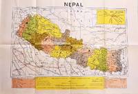
NEPAL
Latest Political Map of Nepal.
Dehli.: Indian Book Depot Map House. 1979. Colour map on blush coloured paper 44.2 x 63.6 cms; 53.6 x 75.9 cms sheet inset map of air service routes folding into pictorial card wrappers 25.5 x 19.3 cms issued into colour pictorial paper folder in very good condition. Map shows Nepal and surrounding borders with India Tibet and China provinces picked out in colour international and state boundaries sealed roads railway lines canals lakes springs rivers towns and villages tourist places temples and the inset map shows air services from Nepal to Thailand and India. The rear wrapper shows a view of Pashupatinath Temple the oldest Hindu temple in Kathmandu. . Indian Book Depot (Map House). unknown
Bookseller reference : 207710
|
|
|
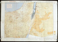
EGYPT AND SINAI WWII MAP.
Egypt. North Sinai. Sheet 3.
London.: Royal Engineers. July1942. Printed colour topographical map mounted on linen 56.7 x 79.2 cms; 64.6 x 89. 5 cms sheet original folds edgewear small marginal chips a little dusty but in good condition. Detailed World War II operational map of Egypt and the Middle East issued by 512 Army Field Survey Company of the Royal Engineers. The map is marked "Not to be Published" in the upper right margin. Railways roads camel tracks telegraph lines boundaries altitudes towns and villages are marked. . Royal Engineers. unknown
Bookseller reference : 207841
|
|
|
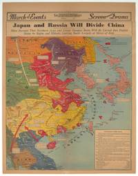
[CHINA - RUSSIA - JAPAN - WORLD WAR II MAP] BURKE, HOWARD.
Japan and Russia Will Divide China. Signs Increase That Northern Area and Lower Yangtze Basin Will be Carved Into Puppet States by Stalin and Mikado Leaving South Largely at Mercy of Both.
Los Angeles.: Los Angeles Examiner. 1940. Printed colour pictorial map on a single newspaper leaf 42.3 x 39.9 cms; 54.3 x 42.5 cms sheet archivally laid down on linen slight discoloration to lower centrefold and sheet slightly age-toned but in very good condition. A striking geopolitical map by Los Angeles Examiner artist Howard Burke covering China Japan Southern Russia and the northern part of French Indochina and Siam showing how the "Aggressors Divide China." Areas under Japanese occupation are shown in red and their naval blockade shown by an arc of naval vessels with vivid arrows indicating lines of supply. Text labels including sources of agricultural and raw materials provide a dynamic overview of the geopolitical situation and show the influence of American scientific illustrator and cartographer Richard Edes Harrison who argued for examining geographic issues from multiple perspectives and Los Angeles Times artist Charles Owens. . Los Angeles Examiner. unknown
Bookseller reference : 209821
|
|
|
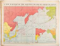
[WWII MAP OF JAPAN AND THE PACIFIC]
A New War Map of the Aleutian Island Sea Road to Japan. caption title
Chicago.: Chicago Daily Tribune. 28 January1942. Printed colour map 40.3 x 53.6 cm; 46.5 x 60 cm sheet inset map of the North Pacific back cover from a section of the Chicago Daily Tribune newspaper pages 21-34 January 28 1942; central fold edgewear and browning with a few minor tears not affecting the map in very good condition. Based on a Rand McNally map and issued less than two months after the bombing of Pearl Harbour by the Japanese. The Tribune briskly got to work issuing maps for readers showing the beginnings of the war with Japan. Later maps were also published for sale separately but remarkably few have survived. The map shows "the nearness of our Aleutian Island chain west of Alaska to the islands of Japan. At Dutch Harbor and other points in the Aleutians are actual and potential sea and air bases lying on the shortest route from northwestern United States to Japan." The inset map at lower right situates the areas in the larger map in respect to the countries bordering the North Pacific Ocean. <br> <br>Included with the map is the complete newspaper section from which it is the final full page. Covering sport and the market with half a dozen popular comic strips including "Dick Tracy" and "Little Orphan Annie" it shows a domestic United States a world away from what had been seen as a European War. <br> <br>". the historic Chicago Tribune was an innovator in color inks and printing but also a pioneer in bringing colorful art in the form of illustrations photographs cartoons and advertisements to the average person in an everyday medium." see The Janet A. Ginsburg Chicago Tribune Collection Michigan State University Libraries." . Chicago Daily Tribune. unknown
Bookseller reference : 206849
|
|
|
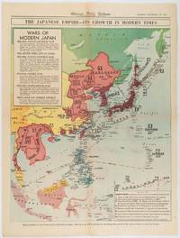
[WWII MAP OF THE JAPANESE EMPIRE] WISNER, W. H.
The Japanese Empire -- Its Growth in Modern Times
Chicago.: Chicago Daily Tribune. December 161941. Printed colour map on a single newspaper leaf 50 x 41.5 cm; 60 x 45 cm sheet two inset legends marginal browning and at the folds but remarkably bright in very good condition. Map of the Japanese Empire published in the Chicago Daily Tribune "The World's Greatest Newspaper" on December 16th 1941 9 days after the bombing of Pearl Harbour. The two legends list the "Wars of Modern Japan" from 1894 with territorial gains marked noting that "Each seizure of mainland areas has given Japan new field of raw materials." <br> <br>"… the historic Chicago Tribune was an innovator in color inks and printing but also a pioneer in bringing colorful art in the form of illustrations photographs cartoons and advertisements to the average person in an everyday medium." see The Janet A. Ginsburg Chicago Tribune Collection Michigan State University Libraries. . Chicago Daily Tribune. unknown
Bookseller reference : 180755
|
|
|
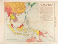
[WWII MAP OF SOUTHEAST ASIA] WISNER, W. H.
New Map of Waters of Australasia.
Chicago.: Chicago Daily Tribune. December 161942. Printed colour map on a single newspaper leaf 41.6 x 52.8 cm; 45 x 60 cm sheet inset legends marginal browning and at the folds but remarkably bright in very good condition. Map of Southeast Asia published in the Chicago Daily Tribune "The World's Greatest Newspaper" delineating the Pacific theatre of war with a detailed text legend. "This is a new war map of the far east showing an important part of southeastern Asia and Australasian waters from a station in which according to Prime Minister Curtin of Australia a United States fleet will operate." Interestingly New Guinea is marked as British rather than as an Australian administrative region which it became following the Treaty of Versailles. <br> <br>"… the historic Chicago Tribune was an innovator in color inks and printing but also a pioneer in bringing colorful art in the form of illustrations photographs cartoons and advertisements to the average person in an everyday medium." see The Janet A. Ginsburg Chicago Tribune Collection Michigan State University Libraries. . Chicago Daily Tribune. unknown
Bookseller reference : 180757
|
|
|
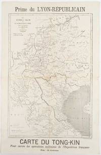
[TONKIN CAMPAIGN - MAP] MEYNIARD, CHARLES; HAUSERMANN, R. (ENGRAVER)
Le Tong-Kin et le Bassin du Fleuve Rouge d'Apres les Documents de J. Dupuis
Lyon.: Lyon-Républicain. circa1883. Engraved map 40.5 x 27.5; 48.9 x 31.8 cm sheet original folds some browning to the fold and margins two small holes at the central fold without significant loss in good condition. Map issued as a supplement to "Le Lyon-Republicain" one of the great radical daily newspapers in Lyon. The map is after documents by French explorer and trader Jean Dupuis 1829-1912 who had explored regions along the Red River in the hopes of establishing trade routes within Vietnam and China and variously published. This supplement was issued on the eve of the Tonkin War in 1883 so that readers could follow the military movements of the French Expeditionary Force. It shows northern Vietnam and into south-western China with provinces marked and river systems in detail. . Lyon-Républicain. unknown
Bookseller reference : 180621
|
|
|
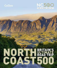
Collins Maps
North Coast 500: Britain's ultimate road trip
Hardback. New. Highly illustrated full colour book showcasing what is unique about the North Coast 500. Striking images and text give a description of the route although with a simple route map showing locations. 100 of the best places to stop on route are included from white sandy beaches to remote mountain tops. hardcover
Bookseller reference : A9780008547059 ISBN : 000854705x 9780008547059
|
|
|
[GALLIPOLI - ANTIQUE MAP] DUMAS-VORZET, E; GERIN, A. (ENGRAVER); GERMAIN, A (HYDROGRAPHER)
Abords et Entrée des Dardanelles. Mer Mediterranée.
Paris.: Service hydrographique et océanographique de la marine. 1883 but1894. Engraved hydrographical chart on watermarked double sheet 99 x 63 cm soundings in metres lighthouses picked out in yellow and red inset map of the port and town of Tenedos central fold a few very slight edge tears to the generous margins light spotting and surface soiling but in very good condition. Fine and impressive large naval chart of this strategically important strait then still under the control of the Ottoman Empire. <br> <br>From a private collection; "Lord John Fitzroy Royal Yacht Squadron" in manuscript on the verso. . Service hydrographique et océanographique de la marine unknown
Bookseller reference : 178272
|
|
|
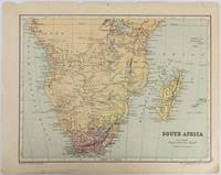
[AFRICA - MAP].
South Africa.
Edinburgh & London.: W. & A. K. Johnston. circa1877. Printed colour map 25 x 32.5 cm edge tears one affecting the lower border only two small chips from the upper margin corner repaired the map in very good condition. Map of North America with a small inset of the British Isles on the verso. Map of Southern Africa before the Scramble for Africa in the late 19th Century. . W. & A. K. Johnston. unknown
Bookseller reference : 177228
|
|
|
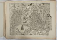
[ENGLISH COUNTY MAPS]
English County Maps in the Collection of the Royal Geographical Society. Reproductions of Early Engraved Maps II.
London.: Royal Geographical Society. 1932. Twenty one loose maps with tissue guards printed on sheets 49.5 x 63.5 cm in the original folio title-wrappers the maps with some edge wear and toning but on the whole in very good condition the wrappers browned and stained torn with minor loss at the foot of the title wrapper small closed edge tears now re-enforced with archival material and sound. Lacking the introductory notes by Edward Heawood. The complete suite of maps: an impressive production. The first map is a general map of England and Ireland by an unknown author 1594; nineteen county maps; and a final sheet of miniature county maps printed as a deck of playing-cards. The county maps proper vary in date from Saxton's “Southamtonia” of 1575 to John Speed's version of Norden's map of Sussex dated 1610. A contemporary reviewer dubbed it " a rich cartographical feast" allowing easy access to rare and valuable maps and comparison of maps by different cartographers for the same county. <br>The county maps reproduced include five by Christopher Saxton three by John Norden Philip Symonson's map of Eastern Kent published in 1596 a series of seven maps dating from the early years of the seventeenth century two maps prepared for Camden and two published by John Speed. . Royal Geographical Society unknown
Bookseller reference : 176499
|
|
|
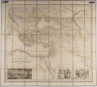
LALLEMAND, ADRIEN TOUSSAINT.
Carte du Théâtre de La Guerre dans L'Empire Ottoman donnant une grande partie des Empires de Russie d.Autriche et de Perse; des Provinces et des Mers ou passent les operations Militaires.
Paris.: Ministère d'Etampes et de Géographies. 1853. Engraved map with outline hand colour 67.2 x 75.1 cm sectioned and linen-backed two large vignettes: a view of Constantinople; and costumed Turks and European soldiers facing off across a stream the linen browned with some loss but not affecting the map with the fine nineteenth century label of Charles Delarue & Hivert on the verso. Fine map with beautiful vignettes by Adrien Toussaint Lallemand 1793 - c.1856 geographer and engraver at the Depôt de la Guerre. Lallemand was appointed at a precociously young age and later set up in business on his own the quality of his work assuring him of the continued business of the Depôt. <br> <br>Highly attractive map of the Ottoman Empire published at the outset time of the Crimean War 1853-1856. <br> <br>This item is held off-site. Please note there may be a few days delay while it is brought into our shop for viewing or mailing to you. Thank you for your understanding. . Ministère d'Etampes et de Géographies unknown
Bookseller reference : 176118
|
|
|
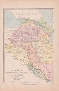
[MIDDLE EAST - MAP.] WELLER, EDWARD.
Armenia Mesopotamia Babylonia and Assyria.
London & Glasgow.: William Collins Sons & Co. circa1870s. Map of ancient Armenia and Mesopotamia printed in colour with the Retreat of the Ten Thousand during the final years of the Peloponnesian War picked out in original hand colour 14.9 x 21.9 cm paper toned at the edges small silverfish abrasions affecting the bottom grid and margin but in very good condition. Text in Latin. . William Collins, Sons & Co. unknown
Bookseller reference : 174962
|
|
|
National Geographic Maps - Trails Illustrated
George Washington National Forest Map Pack Bundle National Geographic Trails Illustrated Map
map. Good. Access codes and supplements are not guaranteed with used items. May be an ex-library book. unknown
Bookseller reference : 1566958628.G ISBN : 1566958628 9781566958622

|
|
|
Franko Maps Ltd.
Hawaiian Sharks & Rays Guide Franko Maps Hawaii Waterproof Fish Card
map. Good. Access codes and supplements are not guaranteed with used items. May be an ex-library book. unknown
Bookseller reference : 1591620295.G ISBN : 1591620295 9781591620297
|
|
|
A-Z Maps
Leeds A-Z Pocket Street Map
Paperback. Very Good. paperback
Bookseller reference : GOR011041996 ISBN : 0008388083 9780008388089

|
|
|
Meds Maps editors of
Nantucket a pictorial guide
Harwich MA: Meds Maps no date. presumed 1st . Soft cover. Fine. 25826 shelf. Unpaginated slim trade paperback photo covers. No names clean text. With stunning color photos. Printed in Italy. Fresh! <br/> <br/> Meds Maps, no date paperback
Bookseller reference : 069862 ISBN : 1890463248 9781890463243
|
|
|
New York City Maps Tourism Nostrand George J.
“View of New York and Vicinity Showing Good Automobile Roads†with “The Only and Original ‘Seeing New York’ Automobiles and Yacht†Pamphlet
George J. Nostrand; Winkoop Hallenbeck Crawford Co 1928. Map measuring 20 x 29 inches; trifold measuring 8 ½ x 12 inches. Map folded with some small tears at folds slightly wrinkled pencil markings verso; very attractive. Overall excellent. Offered here is a large attractive bird’s-eye view map of New York City and the surrounding areas by George J. Nostrand a New York City-based lithographer and cartographer; and a small pamphlet advertising sightseeing tours by car or yacht with “lecturers accompanying each trip explaining all points of interestâ€. The map highlights the most car-friendly routes around the city and New Jersey as far west as Mountain View and is beautifully illustrated with buildings landmarks and ships in the harbor. It was likely produced between 1927 and 1929 given certain details for instance the George Washington Bridge is labeled only as “proposedâ€; we find two copies of the 1928 printing and four of the 1929 printing on OCLC. George J. Nostrand; Winkoop Hallenbeck Crawford Co unknown
Bookseller reference : List2973
|
|
|
Philip's Maps
Philip's Guide to Flags of the World
perfect. Good. Access codes and supplements are not guaranteed with used items. May be an ex-library book. unknown
Bookseller reference : 0540083755.G ISBN : 0540083755 9780540083756

|
|
|
Philip's Maps
Buckinghamshire Philip's Street Atlases
paperback. Good. Access codes and supplements are not guaranteed with used items. May be an ex-library book. paperback
Bookseller reference : 0540086711.G ISBN : 0540086711 9780540086719

|
|
|
Philip's Maps
Bournemouth City Atlas
paperback. Good. Access codes and supplements are not guaranteed with used items. May be an ex-library book. paperback
Bookseller reference : 0540089923.G ISBN : 0540089923 9780540089925
|
|
|
Davis, K.; b & w Plates, Maps [Illustrator]
Britons and Saxons: The Chiltern Region
Phillimore 1982. Hardcover. Very Good. 9x7x0. Hardcover book is pre-owned and in great condition with minimal signs of wear or use on cover corners spine and/or dust cover. Pages are clean and unblemished. A great copy! Phillimore hardcover
Bookseller reference : MED-gs-Britons-060623-vg ISBN : 0850334187 9780850334180
|
|
|
Red Maps
Red Map Los Angeles City Travel Guide
Red Maps 2017-01-01. map. Good. 4x0x8. Travel guide brochure is pre-owned and in good shape with minimal to some signs of wear or use . An entirely readable and usable copy! Red Maps unknown
Bookseller reference : TZVI-gs-LATravel-062123- ISBN : 1892238799 9781892238795
|
|
|
Streetwise Maps
Streetwise Boston Map - Laminated City Center Street Map of Boston Massachusetts - Folding pocket size travel map with MBTA subway map & trolley lines
Used - Good. Used book that is in clean average condition without any missing pages. unknown
Bookseller reference : 6412094-6 ISBN : 0935039082 9780935039085

|
|
 Receive by email
 Download as PDF document
 RSS feed


