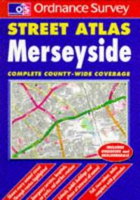
Collins. Very Good. 2020. Paperback. - Book is in great overall condition. No writing or major blemishes. Minor wear.; - We're committed to your satisfaction. We offer free returns and respond promptly to all inquiries. Your item will be carefully wrapped in bubble wrap and securely boxed. All orders ship on the same or next business day. Buy with confidence. . Collins paperback
Bookseller reference : TOB166-14363-A-2.1 ISBN : 0008370028 9780008370022
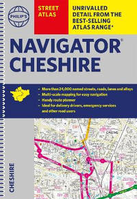
House of Maps. Good. 1998. Unknown Binding. 8vo 8" - 9" tall; The book is in great overall condition showing only minor cosmetic wear.; - We're committed to your satisfaction. We offer free returns and respond promptly to all inquiries. Your item will be carefully wrapped in bubble wrap and securely boxed. All orders ship on the same or next business day. Buy with confidence. . House of Maps unknown
Bookseller reference : OS-6693-TOB4-0.73 ISBN : 0783418264 9780783418261
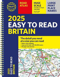
Spiral bound. New. With the detail you need at a size you can read the latest <i>2025 Philip's Easy to Read Road Atlas of Britain</i> has super-clear large-scale large-print maps that everyone can use easily. Practical and chunky with spiral binding. unknown
Bookseller reference : A9781849076661 ISBN : 1849076669 9781849076661
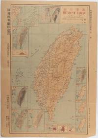
Taiwan.: 禹甸圖書局. Yudian tushuju. 1945. 1945 Ministry of Interior map of Taiwan published in the 34th year of the Republic of China with inset title and key top right. Romanised Japanese names for some areas and cities written in capital letters on main map which is surrounded by 15 small inset maps at edges each with its own scale. Paper browned wear at folds and edges repaired with archival washi on reverse some light stains and a few marks. 1 x 3cm chip bottom right corner. 77.4 x 54 cm. Text in traditional Chinese characters. Inset maps show clockwise from right edge; 1. Distribution of inhabitants according to ethnic background or minority group 2. Qing Dynasty prefectures and counties 3. Japanese administrative regions during the occupation 4. Strategic industrial and military places three city maps - 5.Chilung or Keelung port 6. Taipei city and 7. Tainan city 8. Geological formations 9. agricultural metallurgical and mineral products 10. Soil types 11. Topography of the island including sea currents and altitude diagram 12. Taiwan's position in relation to the mainland coast provinces of Fujian and Zhejiang as well as the Liuqiu Ryukyu Islands including Okinawa 13. Okinawa detail 14. Climate and rainfall in January 15. Climate and rainfall in July. . 禹甸圖書局. [Yudian tushuju]. unknown
NY: Simon and Schuster 1990. First edition with a 1 present in the number line; small 4to.; cloth backed boards hardcover; 1052 pages; red and white illustrations and black white and red maps; very good in a very good unclipped dust jacket. NY: Simon and Schuster, 1990 unknown
Shoreham-by-Sea: Service Publications Map. Good. Map. 9th edition. Folded map in very good condition card cover foxed with light shelfwear. Undated cover price 45p. Service Publications Paperback
Shoreham-by-Sea: Service Publications Map. Good. Map. 1st Edition. Folded map in good condition card cover foxed with light shelfwear both map and cover have old damp damage to top corner. Undated cover price £1.05. Service Publications Paperback
Bookseller reference : 23032733-83 ISBN : 1852820497 9781852820497
Authorhouse 2001-12-01. Paperback. Like New. 2001. Spanish and English Text. Glossy illustrated paper covers; a few small spots on spine otherwise Like New; 8vo 7 3/4" to 9 3/4" tall; inscribed by author on inside of front cover; interior is clean and unmarked; 168 pages. Authorhouse paperback
Bookseller reference : SKU1074721 ISBN : 0759668892 9780759668898
Perth: Hale's Motor Maps Ltd. 1923. Octavo cloth boards with block printed title laid on upper boards b&w plates b&w illus pp 244. Rebound with new endpapers in custom-made slipcase. First page creased otherwise contents clean. Very good condition. Road maps of Western Australia from Moora Kondut and Becubbin in the north to Albany in the south and stretching iinward through the wheatbelt. Scale: 4 miles to the inch. With many illustrated advertisements for WA companies decriptions of Perth and Western Australia with photographs lists of garages and hotels and information for travellers. Boards in slip-case. Hale's Motor Maps Ltd. hardcover
 Receive by email
 Download as PDF document
 RSS feed