|
LABORATOIRES MARINIER - CARTES DE BLAEU
La France : Provinces. Reproductions de 30 cartes de Blaeu 1620-1680.
Laboratoires Marinier 1939. map. <b>Carte géographique en français</b>. - Brochure de 24 pages. 15 x 23 cm. Légèrement défraîchie. <i>ref. 74419</i> Laboratoires Marinier unknown
Bookseller reference : 74419
|
|
|
Field Marshal Viscount French of Yprres KP. OM. etc. with a Preface by Marshal Foch and with Portrait and Maps K. P. O. M.
1914
Houghton Mifflin Company 1919. Hardcover. Acceptable. First ed. with some unopened pages. Although this volume is in excellent condition it is merely "acceptable" because there is only one map in back pocket; the pref. by Marechal Foch is in French but there is a translation in the appendix. 385 p. clean and unmarked anywhere on strong paper only mildly age-toned--no foxing; TEG; tissue guard on frontis. photo-portrait of Viscount French is creased but not torn; holograph of signature on assumes beneath frontis. portrait; binding tight; crimson boards with still bright gilt lettering have light bumping at corners and slight rubbing at some edges. Fascinating primary source. Houghton Mifflin Company hardcover
Bookseller reference : 102091
|
|
|
Dalrymple Byron; Maps by Delos D. Rowe Associates with basic maps courtesy ofRand McNally & Company
Complete Guide To Hunting Across North America
Harper & Row Publishers. hardcover. Good/Unclipped. 9x6x2. Presumed first ed. 1970; 848 p. clean and unmarked anywhere on strong paper mildly age-toned--but darker around edges of end pages suggesting inlaid material at some time; maps and photos; binding tight; despite presence of phtoographic d.j. the boards are much faded around edges and have slight rubbing at corners. D.j. itself is chipped at edges with open tears at crown of spine panel and at upper corner of rear panel. Harper & Row, Publishers hardcover
Bookseller reference : 092469 ISBN : 1199360163 9781199360168

|
|
|
Carell, Paul; Translated from the German Unternehmen Barbarossa by Osers, Ewald with Maps
Hitler Moves East 1941-1943
Little Brown and Company 1964-01-01. hardcover. GOOD/NONE. From a smoker's apartment. 640 mostly clean unmarked tight pages but small stains on fore-edge of textblock bleed very slightly onto pages; small water stain on upper edge of textblock left blue at upper edge of last 35 pages; cracks in front hinge; small stain inside front cover and front flyleaf; cover is sturdy but with corner wear pale stains and light wear at ends of spine Little, Brown and Company hardcover
Bookseller reference : 80887U
|
|
|
Kimble, George HT.; Illustrated by Maps, photos [Illustrator] H. T.
Tropical Africa: Volume I Land and Livelihood and Volume II Society and Polity
20th Century Fund 1960-01-01. Hardcover. Very Good/Unclipped . 0x0x0. Both volumes in this set are immaculate and unmarked except for former owner's name on front end pages; many interesting period photos in both vols.; bindings firm; boards fine well-protected by very good d.j.s having minimal wear. Collectible first edition. 20th Century Fund hardcover
Bookseller reference : 042296
|
|
|
Hale, EE. And Susan; Maps and Profuse Woodcuts [Illustrator] E. E.
A Family Flight Through Mexico
D. Lothrop 1893-01-01. Hardcover. VERY GOOD/NONE. Cover alone is worth the purchase. Very lightly bumped corners. Cover is a piece of art. D. Lothrop hardcover
Bookseller reference : 039254
|
|
|
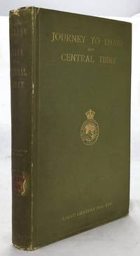
Das, Sarat Chandra (edited By WW. Rockhill; Frontispiece Photo of Author, 2 Large Folding Maps, 4 Folding Color Plans [Illustrat
Journey to Lhasa and Central Tibet
John Murray 1/1/1902. Stated 2nd Edition revised. Hardcover. Good. Bound in publisher's green cloth. Gilt lettered and stamp of the Royal Geographical Society on front cover. Library stamps and markings. 285 pages. 34 illustrations and maps 6 of which are folding. Large color map of Tibet at rear. Many of the plates are stamped with library stamps on blank side. <br> Sarat Chandra Das 1849-1917 was a Bengali scholar of Tibet. Das has been described as "a traveler explorer.linguist a lexicographer an ethnographer and an eminent Tibetologist." Das was also a British spy. Born in Chittagong Das trained as an engineer in Calcutta. He became headmaster of the Bhutia Boarding School in Darjeeling. Bhutia was a school for Sikkimese and Tibetan boys many of who would be trained to fill a special place in the British colonial regime the role of a Pundit. Das became a "pundit" and an instructor at the school for British intelligence. Pundits acted as a network of British-trained operatives who were tasked to make inroads in the foreboding inner regions of Asia where white embassies could not gain entry. Tibet and other inland areas were increasingly gaining attention from competing British Russian and Chinese economic and strategic interests. Derek Waller speculates that the character of Huree Chunder Mookerjee in Kipling's Kim was based on Das p.193. As a teacher Das learned Tibetan to speak with his students. He read the limited books on the region available notably of Bogle 1773-5 and Manning's travels 1811 to Tibet. Manning and Bogle were the last successful British explorations of Tibet a nation who steadfastly resisted western intrusion. Das's language ability secured him entry with his colleague Lama Ugyen Gyasto to Tashilhunpo monastery in 1879 as the Prime Minister wished to learn Hindi from him. In 1881 Das returned to Tashilhunpo and made his way to Lhasa Sakya and the Tsangpo River. There he met with Thupten Gyatso the 13th Dalai Lama d. 1933 and returned to Darjeeling with a Yak loaded with over 200 Tibetan manuscripts. After Das was revealed to be a British agent Tibetan authorities increased restrictions on travelers and the Minister who had sponsored his entry was put to death. What makes Das's expedition so interesting is that he successfully brought back a wealth of information on an unknown land to the larger world. The Tibet that Das glimpsed is now gone with the passage of history and the destructive forces of modernity and Chinese domination. This book compiles the story of Das's journey his reports photographs diagrams ethnographic observations etc of a lost Tibet. Das went on to become an important Tibetan scholar and author an extensive multi-volume dictionary. The British would not successfully return to Tibet until 1903-4 with Colonel Francis Edward Younghusband's exhibition invasion and massacre of ~5000 Tibetans. Significantly Younghusband was the President of the Royal Geographical Society which notably published the 1902 edition of Das's book. An interesting and dark connection to Das's legacy. Ref: Derek Waller's The Pundits: British Exploration of Tibet and Central Asia. University Press of Kentucky 1990 pp. 193-209. Also Samanth Subramanian's superb piece in the New York Times Magazine March 20 2016 p. MM61. Peter Hopkirk The Great Game: The Struggle for Empire in Central Asia Kodansha 1992. Yakushi D55 Yakushi D356. Marshall 1459 John Murray hardcover
Bookseller reference : 1607050057
|
|
|
Collins Maps
2014 Collins Handy Road Atlas Britain
Paperback. Good. paperback
Bookseller reference : GOR006057018 ISBN : 0007497105 9780007497102
|
|
|
Horton Family Maps
Street maps Santa Fe Espanola Los Alamos Taos
Horton Family Maps. Used - Good. Good condition. A copy that has been read but remains intact. May contain markings such as bookplates stamps limited notes and highlighting or a few light stains. Horton Family Maps unknown
Bookseller reference : S17M-01576 ISBN : 0883077663 9780883077665
|
|
|
Hilda Cartes
Karma
Grupo Editorial CÃrculo Rojo S.L. 2019. Paperback. New. 160 pages. Spanish language. 8.27x5.91x0.40 inches. Grupo Editorial CÃrculo Rojo S.L. paperback
Bookseller reference : 2-8413174546 ISBN : 8413174546 9788413174549
|
|
|
Michelin Maps
Southern France Map Michelin Maps French Edition
<p>Fair. Map is generally clean and all fold lines appear to be in good shape. Notes on back or front depending on your point of view. Creased edges. should have images</p> Pneu Michelin
Bookseller reference : DM-SJTC-WZZ9 ISBN : 2067009192 9782067009196
|
|
|
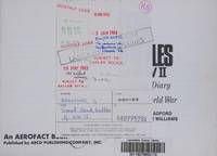
Bradford, George & Lorne Williams (maps by)
Great Tank Battles of WW II A Combat Diary of the Second World War
Arco Publishing Company. Very Good. 1970. First Edition; First Printing. Softcover. 0668022884 . Perfect bound illustrated softcover sharp and square with mild shelf wear. Very Good. Book is firm in its binding 96 pages with b&w historic photographs and illustrations. Very Good . Free of any markings not ex-library. ; An Aerofact Book; B&W Photos & Illustrations; Oblong 8vo 8" to 9" tall; 96 pages . Arco Publishing Company paperback
Bookseller reference : 97947 ISBN : 0668022884 9780668022880
|
|
|
ZIEGLER, Victor, Illustrated by Maps
POPULAR OIL GEOLOGY
New York: John Wiley And Sons 1920. SSecond Edition Revised. Hardcover. Very Good. 16mo 171 pages red fabricoid <br/><br/>Substantially re-written from the 1918 edition. Inscribed by the author a geology professor to L. B. Stoers. Ziegler was with the Colorado School of Mines. John Wiley And Sons hardcover
Bookseller reference : 002051
|
|
|
Bacon's Maps
Bacon's Country Map and Guide. Lincoln with parts of adjoining Counties.
United Kingdom: G. W. Bacon & Co. . Folding map with a pictorial cover 19 pages booklet and adverts attached to inner cover. A few darkened marks to cover and also some normal wear and light creasing around corners etc. Staples are rusty but sound. Size 47cm x 68 cm. Slight tear to one fold of map see image from Winghale Books. no date but census used for statics is 1901 so Edwardian. . Good. Soft cover. 1911. G. W. Bacon & Co. paperback
Bookseller reference : 102189
|
|
|
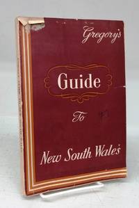
Gregory's Guides and Maps
Gregory's Guide To New South Wales
Sydney ca. 1957. Softcover. Good. 304 p. 24 cm. Maps and illustrations. Chips and tears to edges scuff at top front ink notation on front. Paper browning. A few ink stamps. <br/><br/>Lists populations of communities rail distances between stations shires and their headquarters etc. Descriptions of communities from Albury to Young. Hotel advertisements. paperback
Bookseller reference : 148324
|
|
|
Thomas Bros. Maps
Los Angeles/Orange counties street guide and directory
Thomas Bros. Maps 1991-01-01. Unbound. Good. 1.2000 11.2000 8.5000. Thomas Bros. Maps unknown
Bookseller reference : mon0003406651 ISBN : 0881305154 9780881305159
|
|
|
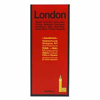
Red Maps
Red Maps LONDON Street Map and City Guide
Paperback. Very Good. paperback
Bookseller reference : GOR013673933 ISBN : 1892238888 9781892238887
|
|
|
Harvey Maps
Lake District North Ultramap
Harvey Map Services Ltd 2016. Map. New. 1 pages. 7.17x3.78x0.24 inches. Harvey Map Services Ltd unknown
Bookseller reference : 2-1851375694 ISBN : 1851375694 9781851375691
|
|
|
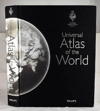
Philip's Maps
Philip's Universal Atlas of the World
Philip's 2008-10-06. Hardcover. Very Good. 12x2x17. Bound in publisher's cloth. Hardcover. Lacking slip case. Good binding and cover. Shelf wear. Corner chipped. Clean unmarked pages. 584 pages : illustrations chiefly color chiefly color maps ; 39 cm. <br> Includes maps of each state in the USA and large-scale maps of Britain and Ireland; Canada; Mexico; Scandinavia; Israel Lebanon and Jordan; Central Asia; Korea; Taiwan; Australia; New Zealand; and the islands of the Caribbean Indian Ocean and Pacific. This title includes a set of five ocean floor maps and maps of Moon and the night sky. <br> This is an oversized or heavy book which requires additional postage for international delivery outside the US. Philip's hardcover
Bookseller reference : 2401030033 ISBN : 0540090166 9780540090167
|
|
|
Works Progress Administration; Federal writers' Project; Maps [Illustrator]
Washington - City and Capital American Guide Series
Government Printing Office 1937. hardcover. Very Good. 0x0x0. Bound in publisher's cloth. Hardcover. No dust jacket. Good binding and cover. Spine faded. Clean unmarked pages. Includes map in rear pocket. xxvi. 1140 pages. <br> The American Guide Series was a group of books and pamphlets published under the auspices of the Federal Writers' Project FWP a Depression-era works program in the United States. The American Guide Series books were compiled by the FWP but printed by individual states and contained detailed histories of each state with descriptions of every city and town. The format was uniform comprising essays on the state's history and culture descriptions of its major cities automobile tours of important attractions and a portfolio of photographs. Government Printing Office hardcover
Bookseller reference : 2306200115
|
|
|
Glenn Tucker; Dorothy Thomas Tucker, Maps [Illustrator]
Dawn like Thunder : The Barbary Wars and the Birth of the U.S. Navy
Bobbs 1963. hardcover. Very Good. 11x9x7. Hardcover. No dust jacket. Good binding and cover. Clean unmarked pages. Bobbs hardcover
Bookseller reference : 2212070042
|
|
|
Johnston, G. & P. Foote; Maps [Illustrator]
Saga of Gisli
J. M. Dent & Sons Ltd 1963-01-01. Hardcover. Good. Icelandic Sagas Hardcover and dust jacket. Good binding and cover. Shelf wear. Tears to jacket with loss. Scattered underlining and markings. <br> "The Saga of Gisli was written early in the 13th century. It offers an imaginative reconstruction of the story of a man and his family who came to Iceland from Norway about A.D. 950. Soon after 960 Gisli was outlawed for killing his brother-in-law and then for thirteen years or more he lived in hiding in remote parts of the northwest of Iceland until he was finally caught and killed by his enemies. J. M. Dent & Sons Ltd hardcover
Bookseller reference : 2208290120 ISBN : 0460035754 9780460035750
|
|
|
Alden, John B.; Illustrated with Thirty-Eight Colored Maps, Diagrams, Tables ,Etc. [Illustrator]
Alden's Handy Atlas Of The World
NY: John B. Alden Publisher 1887 1887-01-01. Hardcover. Very Good. Bound in publisher's cloth. Hardcover. No dust jacket. Good binding and cover. Clean unmarked pages. 191 pages : color illustrations color maps ; 16 cm. "including one hundred and thirty-eight colored maps diagrams tables etc NY: John B. Alden, Publisher, 1887 hardcover
Bookseller reference : 2210070050
|
|
|
Lewis Lloyd; Engravings & Maps Photos [Illustrator]
Sherman Fighting Prophet
Harcourt Brace & Co. NY 1958-01-01. Hardcover. Very Good. 8x5x1. Hardcover and dust jacket. Good binding and cover. Clean unmarked pages. Dust jacket in protective mylar cover. Wear to dj. Stamp on fep. Harcourt Brace & Co., NY hardcover
Bookseller reference : 2205120146 ISBN : 015181905X 9780151819058
|
|
|
Baedeker, Karl; 30 Maps and 34 Town and Building Plans [Illustrator]
Italy: Handbook for Travellers: Third Part: Southern Italy and Sicily: With Excursions to Sardinia Malta and Corfu
Baedeker 1912-01-01. 16th Edition. Hardcover. Good. 16mo. Red cloth. vi 508 p. fold. front. maps part fold. plans part fold. with 30 maps and 34 plans. 16 cm. Clean unmarked pages. Some tears to maps with some being maps loose. Rubbing to cover. <br><br> Founded in 1827 Baedeker guides gained popularity during the second half of the 19th century so much so that Baedekering became part of everyday language. They were an invaluable and essential part of civilized travel in the fin-de-siecle. Baedeker guides were known for both their accuracy and attention to detail. Included in each are intricate colored fold-out maps and floor plans. Baedekers comments and recommendations open a fascinating window into the mores of a world now past. Baedeker hardcover
Bookseller reference : 2205190129
|
|
|
Baedeker, Karl; 30 Maps and 34 Town and Building Plans [Illustrator]
Italy: Handbook for Travellers: Third Part: Southern Italy and Sicily: With Excursions to Sardinia Malta and Corfu
Baedeker 1912-01-01. 16th Edition. Hardcover. Good. Bound in publisher's red cloth. Shelf wear/bumping/fraying. Gutters weakened. lvi 508 pages 49 unnumbered leaves of plates some folded : maps plans ; 16 cm. with 30 maps and 34 plans. <br><br> Founded in 1827 Baedeker guides gained popularity during the second half of the 19th century so much so that Baedekering became part of everyday language. They were an invaluable and essential part of civilized travel in the fin-de-siecle. Baedeker guides were known for both their accuracy and attention to detail. Included in each are intricate colored fold-out maps and floor plans. Baedekers comments and recommendations open a fascinating window into the mores of a world now past. Baedeker hardcover
Bookseller reference : 2205190131
|
|
|
Mehta, Ved; Endpaper Maps [Illustrator]
Portrait of India
Farrar Straus and Co 1970-01-01. Hardcover. Very Good. 9x6x1. Farrar printing. Hardcover and dust jacket. Good binding and cover. Shelf wear. Pages unmarked. Farrar, Straus, and Co hardcover
Bookseller reference : 2203160073 ISBN : 0297000721 9780297000723
|
|
|
Richards, T Addison; Fold Out Maps One with Short Tear But Complete [Illustrator]
Appleton's Companion Hand Book of Travel Containing a full description of the principal cities towns and places of interest together with hotels and routes of travel through the United States and the Canadas. With Colored Maps
D Appleton and Company 1862. Hardcover. Good. 1962 printing. Bound in publisher's cloth. Hardcover. Shelf wear. Spine ends chipped with loss. Some folded maps torn. D Appleton and Company hardcover
Bookseller reference : 2109160014
|
|
|
Holborn Hajo; Maps Illustrator
History of Modern Germany: 1840-1945 v. 3
Alfred A Knopf 1969-01-01. Hardcover. Good. Hardcover and dust jacket. Good binding and cover. Underlining. DJ torn along spine. Bookplate. Alfred A Knopf hardcover
Bookseller reference : 2104200009 ISBN : 0413277003 9780413277008
|
|
|
Baedeker, Karl; Illustrated by Illustrated, folding maps. [Illustrator]
Baedeker's Belgium and Holland: A Handbook For Travelers
Karl Baedeker 1897. 7th Ed. Hardcover. Good. 1897 printing. Bound in publisher's red cloth. Hardcover. Good binding and cover. Shelf wear. Light water damage to edges of front end pages does not affect text. <br> Founded in 1827 Baedeker guides gained popularity during the second half of the 19th century so much so that Baedekering became part of everyday language. They were an invaluable and essential part of civilized travel in the fin-de-siecle. Baedeker guides were known for both their accuracy and attention to detail. Included in each are intricate colored fold-out maps and floor plans. Baedekers comments and recommendations open a fascinating window into the mores of a world now past. Karl Baedeker hardcover
Bookseller reference : 2101140060
|
|
|
Ely, Susan H.; Plimpton, Elizabeth B.; b&w photos drawings maps [Illustrator]
The Lieutenant River
Lyme Historical Society 1991-01-01. Paperback. Very Good. Softcover. Good binding and cover. Clean unmarked pages. Light foxing to edge. Lyme Historical Society paperback
Bookseller reference : 1907180039
|
|
|
Murdoch, James with Maps by Isoh Yamagata
A History of Japan 3 Volumes : Vol I - from the Origins to the Arrival of the Portuguese in 1542 Vol II - During the Century of Early Foreign Intercourse 1542-1651 Vol III - the Tokugawa Epoch 1652-1868
Kegan Paul Trench Trubner 1926. Hardcover. Very Good. 3 volume set. Bound in publisher's green cloth with gilt lettering. Very good bindings and covers. viii 667 viii 743 xvi 823 pp index many color folding maps. Light foxing. Contents: Vol. 1. From the origins to the arrival of the Portuguese in 1542 A.D.; Vol. 2. During the century of early foreign intercourse 1542-1651; Vol. 3. Tokugawa epoch 1652-1868. Vol. 3 revised and edited by Joseph H. Longford. At Longford's death the work was transferred to L.M.C. Hall. Maps by Isoh Yamagata. First published in 1903 Murdoch's work quickly became an important reference in Japanese history. <br> This is an oversized or heavy book which requires additional postage for international delivery outside the US. Kegan Paul, Trench, Trubner hardcover
Bookseller reference : 1808090055
|
|
|
Murdoch, James with Maps by Isoh Yamagata
A History of Japan 3 Volumes : Vol I - from the Origins to the Arrival of the Portuguese in 1542 Vol II - During the Century of Early Foreign Intercourse 1542-1651 Vol III - the Tokugawa Epoch 1652-1868
Kegan Paul Trench Trubner 1949-01-01. Hardcover. Good. 3 volume set. Bound in publisher's green cloth with gilt lettering. Very good bindings and covers. Spines slightly sunned. viii 667 viii 743 xvi 823 pp index many color folding maps. Light foxing. Contents: Vol. 1. From the origins to the arrival of the Portuguese in 1542 A.D.; Vol. 2. During the century of early foreign intercourse 1542-1651; Vol. 3. Tokugawa epoch 1652-1868. <br> Vol. 1-2 3rd impression. Vol. 3 1st impression. Vol. 3 revised and edited by Joseph H. Longford. At Longford's death the work was transferred to L.M.C. Hall. Maps by Isoh Yamagata. First published in 1903 Murdoch's work quickly became an important reference in Japanese history. <br> This is an oversized or heavy book which requires additional postage for international delivery outside the US. Kegan Paul, Trench, Trubner hardcover
Bookseller reference : 1807230045

|
|
|
Morse Jedidiah and Rev. Elijah Parish; 17 folding maps as called for Illustrator
A new gazetteer of the Eastern continent : or A geographical dictionary ; containing in alphabetical order a description of all the countries kingdoms states cities towns principal rivers lakes harbours mountains &c. &c. in Europe Asia Africa and their adjacent islands
imprint of Samuel Etheridge 1802-01-01. Leather Bound. Good. Bound in contemporary full calf. Gilt ruled red leather spine label. Wear rubbing to cover. Solid binding. 712 pages 18 pages of plates : illustrations 17 folded maps ; 23 cm. Intended as the second volume to the American Gazetteer. Scattered foxing. imprint of Samuel Etheridge hardcover
Bookseller reference : 1610270044

|
|
|
Baedeker, Karl; Illustrated by Illustrated, folding maps. [Illustrator]
Baedeker's Belgium and Holland: A Handbook For Travelers
Karl Baedeker 1/1/1910. 7th Ed. Hardcover. Good. 15th Edition. 489p. maps. Bound in publishers red cloth. Good binding and cover. Shelfwear. Library markings. <br> Founded in 1827 Baedeker guides gained popularity during the second half of the 19th century. The guides contain among other things maps and introductions; information about routes and travel facilities; and descriptions of noteworthy buildings sights attractions and museums written by specialists. Karl Baedeker hardcover
Bookseller reference : 1607190006
|
|
|
Baedeker, Karl; Illustrated by Illustrated, folding maps. [Illustrator]
Baedeker's Belgium and Holland including the grand-duchy of Luxembourg; handbook for travellers
Karl Baedeker 1/1/1910. 7th Ed. Hardcover. Very Good. Red cloth. 15 ed. lxxxii 489 pages 19 maps some folded 45 plans some folded 16 cm. With 19 maps 37 plans of towns and 8 ground plans. Hardcover. Good binding and cover. Clean unmarked pages. Ships daily. <br><br> Founded in 1827 Baedeker guides gained popularity during the second half of the 19th century so much so that Baedekering became part of everyday language. They were an invaluable and essential part of "civilized travel" in the fin-de-siecle. Baedeker was known for both its accuracy and attention to detail. Included in each are intricate colored fold-out maps and floor plans. Baedeker's comments and recommendations open a fascinating window into the mores of a world now past. <br><br>An interesting side note: Literary references to Baedeker's abound from E. M. Forester's A Room with a View to Mark Twain's A Tramp Abroad. T.E. Lawrence is reputed to have used Baedeker's guide to Palestine during his Doctoral work in the Levant and prompted his Allied superiors to make facsimile copies during WWI. <br><br>During the Luftwaffe's Vergeltungsangriffe the guides were important enough to be reportedly cited by Gustav Braun von Stumm that "We shall go out and bomb every building in Britain marked with three stars in the Baedeker Guide."3 In the so-called "Baedeker Blitz" of 1942 the English cities of Exeter Bath Norwich York and Canterbury were bombed. Karl Baedeker hardcover
Bookseller reference : 1603140008
|
|
|
GPO. 1933.; 2 large foldout maps. Illustrator G. P.
Sailing Directions for the Pacific Islands Eastern Groups Volume II
G.P.O Washington D.C 1/1/1933. Hardcover. Good. Supplement to Hydrographic Office Publication No. 166 Bound in publishers olive cloth. Gilt lettering to front cover and spine. Good binding and cover. Soiling to boards and spine. Errata intensively throughout volume updated from 1936 as noted by errata title page. Name to front pastedown. Soiling to title page. Tanned pages. Wear to a few pages. Ships daily. G.P.O, Washington, D.C hardcover
Bookseller reference : 1511100003
|
|
|
Destenay, Anne L.; Illus. with maps [Illustrator]
China: Nagel's Encyclopedia-Guide
Nagel Publishers 1/1/1968. Hardcover. Very Good. 1504 32 pages 14 maps 16 cm. Hardcover and dust jacket. Good binding and cover. Wear chipping to dust jacket. This is an oversized or heavy book that requires additional postage for international delivery outside the US. Nagel Publishers hardcover
Bookseller reference : 1505130108
|
|
|
Baedeker Karl; 12 maps 36 Plans Illustrator
Paris & Environs With Routes From London to Paris/ Handbook for Travellers
Baedeker Pub 1/1/1900. 14th Revis Ed. Hardcover. Very Good. Red cloth. lvi 420 p. maps part fold. plans part fold. 16 cm. Clean unmarked pages. Colored fold-out maps in good condition. Good binding and cover. <br><br>Founded in 1827 Baedeker guides gained popularity during the second half of the 19th century so much so that Baedekering became part of everyday language. They were an invaluable and essential part of civilized travel in the fin-de-siecle. Baedeker guides were known for both their accuracy and attention to detail. Included in each are intricate colored fold-out maps and floor plans. Baedekers comments and recommendations open a fascinating window into the mores of a world now past. <br><br> with 12 maps and 36 plans. Appended 36 p. fold. plans: Index of streets and plans of Paris. Baedeker Pub hardcover
Bookseller reference : 1304240105
|
|
|
Clarence Edwin (editor/compiler) Carter; Illustrator-bw maps
Territorial Papers of the United States: The Territory of Alabama 1817-1819 vol. 18
Government Printing Office 1952. Hardcover. Very Good. xiii 875 p.; 26 cm. Blue cloth. Good binding and cover. Shelf wear. Clean unmarked pages. Government Printing Office hardcover
Bookseller reference : 1204090009
|
|
|
John J. Pershing; Illustrator-Charts Many Fold Out Maps
Final Report of Gen. John J. Pershing Commander-in-Chief American Expeditionary Forces
Government Printing Office 1920. Paperback. Very Good. 8vo. Softcover. Good binding and cover. Chipping and loss to tail of spine. Minor wear to extremities. 95 p. 1l. : 16 pl. fold. maps diagrs. part fold. ; 24 cm. Contents: pt. 1. Period of organization; pt. 2. Operations; pt. 3. Supply coordination munitions and administration; pt. 4. Mscellaneous subjects. Clean unmarked pages with minimal toning. Foldout maps in crisp clean condition with no tears or excessive wear. Please feel free to view our photographs. Government Printing Office paperback
Bookseller reference : 1203080035
|
|
|
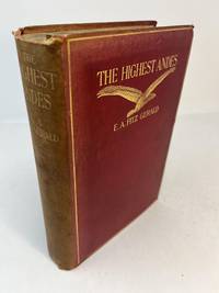
Gerald, E. A. Fitz. With chapters by Stuart Vines. Maps by A. E. Lightbody
THE HIGHEST ANDES. A Record of the First Ascent of Aconcagua and Tupungato in Argentina and the Exploration of the Surrounding Valleys
London: Methuen & Co 1899. 1st edition. Hardcover. Good. A. E. Lightbody. 1st edition thus 1899. A Good copy. 4to. 390 pp. with two maps at rear. Bound in red cloth with titles in gilt on front cover and spine. Spine is faded; tips edges and spine; frontis page partially detached; scattered foxing throughout. Methuen & Co hardcover
Bookseller reference : 31462
|
|
|
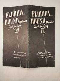
Butler, G. Vincent and Edith Malmgreen Butler with maps by George A Hefferman
Florida Bound Motoring Guide for 1938 By Way of US 1
St Petersburg FL and Newark NJ: G Vincent Butler 1938. 3rd Annual Edition; 8vo.; wraps with stapled binding softcover; 12 pages; black and white illustrations; "An Annual guide for North-South motorists with detailed strip maps and recommended accommodations"; creased down the middle else very good. <br/><br/> St Petersburg, FL and Newark, NJ: G Vincent Butler, 1938 paperback
Bookseller reference : 45711
|
|
|
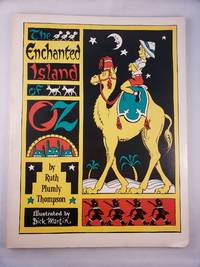
Thompson, Ruth Plumly, illustrated by Dick Martin and maps by James E. Haff
The Enchanted Island Of Oz
The International WIzard of Oz Club Inc. 1976. Small 4to.; illustrated stiff wraps softcover; 77 pages; black and white illustrations and maps; from the title page "founded on & continuing the famous OZ stories by L. Frank Baum"; a sunned errata slip laid in; bottom corner is bumped else very good. <br/><br/> The International WIzard of Oz Club, Inc., 1976 paperback
Bookseller reference : 45456
|
|
|
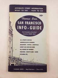
Thomas, Camille E. and Thomas Bros. Maps
Thomas Bros. San Francisco Info-Guide Showing All Streets Street car and bus transportations systems Hotels Buildings Amusements Points of Interest Etc.
San Francisco: Thomas Bros. Map Publishers 1957. 12mo.; illustrated stiff wraps with stapled binding softcover; 48 pages with fold-out map softcover; black and white photographic illustrations; wraps are sunned else very good. <br/><br/> San Francisco: Thomas Bros. Map Publishers, 1957 paperback
Bookseller reference : 45497
|
|
|
Boston Rare Maps
REFORMERS & VISIONARIES SCOUNDRELS & INCENDIARIES - 250 YEARS OF PERSUASIVE MAPPING - CATALOG 3
Southampton MA: Boston Rare Maps 2019. PB. very good wraps softcover faint bump top corner. color illustrations. Faint bump top corner otherwise fine. 86pp. Boston Rare Maps unknown
Bookseller reference : BOOKS069730I
|
|
|
Cooley, John K. (maps by Charles McDonnell)
BAAL CHRIST AND MOHAMMED - RELIGION AND REVOLUTION IN NORTH AFRICA
New York: Holt Rinehart and Winston 1965. HC. good white cloth hardcover no dustjacket - EX-LIB w/one mark. 369pp. Holt, Rinehart and Winston unknown
Bookseller reference : BOOKS060158I
|
|
|
National Geographic Maps
National Geographic Map Supplement Only: The Making of America: Texas March 1986
National Geographic Society 1986. Map. Very Good/no dj. National Geographic Society 1986. Eleventh in a series of seventeen maps. Supplement to the National Geographic March 1986 Page 310A Vol.169 No.3-Texas. A little yellowed else in very good shape. Original folds. Very Good. National Geographic Society unknown
Bookseller reference : 000844
|
|
|
[Pacific Northwest Maps] Hayes, Derek.
Historical Atlas of Washington and Oregon with Original Maps.
<p>Berkeley:: University of California Press 2011. First Printing of the First US Edition. A Fine copy in a Fine bright unclipped dust jacket. This gorgeous atlas illustrated throughout with more than 500 colorful images and maps provides a visually rich and textually engaging history of the states of Oregon and Washington. Derek Hayes brings his enthusiasm and expertise to a full range of topics beginning with the first inhabitants and tracing the westward expansion conflict between settlers and Native Americans and the establishment of the Oregon Trail. We see in vivid images old maps and lively text the coming of the railroads and the rapid establishment of the coastal ports northwest cities and roads the fur and lumber industries and the large farms.</p> University of California Press, hardcover
Bookseller reference : 28184 ISBN : 1570612153 9781570612152

|
|
|
AG MAPS
MAP OF HOPWOOD HALL & THORNHAM 1907
Great Britain: Alan Godfrey Maps. Very Good. 2013. 1847846580 Old Ordannce Survey Maps MAP OF HOPWOOD HALL & THORNHAM 1907 . Alan Godfrey Maps unknown
Bookseller reference : 103691 ISBN : 1847846580 9781847846587
|
|
 Receive by email
 Download as PDF document
 RSS feed


