|
Thomas Brothers Maps
California Road Atlas and Driver's Guide 1994
Thomas Brothers Maps 1994-03-01. Paperback. Good. 1.0000 11.5000 9.0000. Moderate wear and creases. Thomas Brothers Maps paperback
Bookseller reference : mon0003030288 ISBN : 0881306258 9780881306255
|
|
|
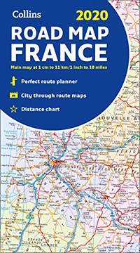
Collins Maps
2020 Collins Map of France
Paperback. Very Good. paperback
Bookseller reference : GOR012403415 ISBN : 0008319774 9780008319779
|
|
|
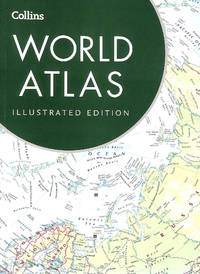
Collins Maps
Collins World Atlas: Illustrated Edition
Collins 2016-03-10. Sixth edition. Paperback. Very Good. 12x9x1. . Posted within 1 working day. 1st class tracked post to the UK Airmail tracked worldwide. Robust recyclable packaging. Collins paperback
Bookseller reference : 230473 ISBN : 0008136629 9780008136628
|
|
|
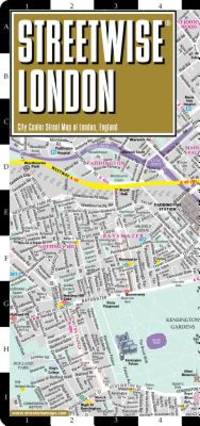
Streetwise Maps
Streetwise London Map - Laminated City Center Street Map of London England
map. Good. Access codes and supplements are not guaranteed with used items. May be an ex-library book. unknown
Bookseller reference : 0935039279.G ISBN : 0935039279 9780935039276
|
|
|
Philip's Maps
Philip's Atlas of the Universe
Hardback. Like New. hardcover
Bookseller reference : GOR011298076 ISBN : 0540077143 9780540077144

|
|
|
National Geographic Maps - Trails Illustrated (Corporate Author)
Appalachian Trail: Davenport Gap to Damascus North Carolina Tennessee
Natl Geographic Maps 2015. Paperback. New. fol map edition. 48 pages. 9.25x4.50x0.25 inches. Natl Geographic Maps paperback
Bookseller reference : 2-1597756393 ISBN : 1597756393 9781597756396

|
|
|
Harvey Maps
Malvern Hills Area of Outstanding Natural Beauty
Paperback. Very Good. paperback
Bookseller reference : GOR008454358 ISBN : 185137423X 9781851374236

|
|
|
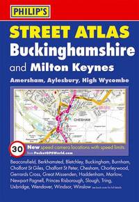
Philip's Maps
Philip's Street Atlas Buckinghamshire: Pocket Edition
Paperback. Very Good. paperback
Bookseller reference : GOR005380796 ISBN : 0540092991 9780540092994
|
|
|
Philip's Maps
Philip's Millennium Encyclopedia 2001
Hardback. Good. hardcover
Bookseller reference : GOR002572658 ISBN : 0540079154 9780540079155

|
|
|
Philip's Maps
Philip's Street Atlas Wiltshire and Swindon: Pocket Edition
Paperback. Very Good. paperback
Bookseller reference : GOR004913951 ISBN : 1849071772 9781849071772

|
|
|
Philip's Maps
Philip's Encyclopedic World Atlas: Country by Country
Hardback. Very Good. hardcover
Bookseller reference : GOR001454609 ISBN : 0540082376 9780540082377
|
|
|
Collins Maps
Collins World Atlas: Complete Edition
Collins 2012-10-09. hardcover. Used: Good. 10.50x1.10x14.50. Buy with confidence. Excellent Customer Service & Return policy. Collins hardcover
Bookseller reference : SONG0007456107 ISBN : 0007456107 9780007456109

|
|
|
Philip's Maps
Philip's Street Atlas: East Kent
Hardback. Good. hardcover
Bookseller reference : GOR002168521 ISBN : 0540079774 9780540079773

|
|
|
Masters Journal 1992 McDermott, John R. Ed; Glossy Color Photos, MAPS [Illustrator]
Masters Journal 1992
Events Pub; Golf Digest 1992-01-01. Unknown Binding. Like New. Oversize. Appears unused with no marks or inscriptions. Light general shelf wear. Events Pub; Golf Digest unknown
Bookseller reference : 004105
|
|
|
Philip's Maps
Philip's Street Atlas South Hampshire
Paperback. Good. paperback
Bookseller reference : GOR001872937 ISBN : 0540087726 9780540087723
|
|
|
Philip's Maps
Philip's Street Atlas Hertfordshire: Pocket Edition
Paperback. Very Good. paperback
Bookseller reference : GOR004037311 ISBN : 1849071799 9781849071796
|
|
|
Philip's Maps
Surrey Street Atlas
Paperback. Very Good. paperback
Bookseller reference : GOR003036150 ISBN : 0540059846 9780540059843
|
|
|
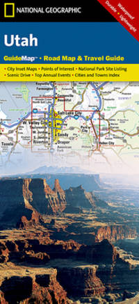
National Geographic Maps
Utah National Geographic Guide Map
National Geographic 2014-11-07. 2014. map. Used: Good. 4.25x0.25x8.75. Buy with confidence. Excellent Customer Service & Return policy. National Geographic unknown
Bookseller reference : SONG159775014X ISBN : 159775014X 9781597750141
|
|
|
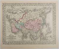
[ANTIQUE MAPS - ASIA AND CENTRAL ASIA] MITCHELL JR., S. AUGUSTUS
Map of Asia Showing its Gt. Political Divisions and also the Various Routes of Travel Between London & India China & Japan &c. with Map of Persia Arabia Turkey in Asia Afghanistan Beloochistan.
Pennsylvania. 1879. Lithographed maps on two sides of a single leaf with original hand-colouring 27 x 34 cms map size 31.1 x 37.1 cms sheet with a finely-engraved foliated border margins age-toned one margin tide-marked at the edge not affecting the maps a handsome pair of maps in very good condition. A most attractive pair of late 19th Century maps on two sides of a single leaf: Asia as a whole polar projection with Europe and parts of Africa and New Guinea. Scale 1:1000 miles. It includes steamship routes and mileages from London to destinations in Asia: Zhoushan Chusan Island Hong Kong Manilla Sarawak Bombay etc. along with political and geographical details; and on the verso the map covers the regions of Persia Iran Arabia including parts of the Arabian Peninsula Turkey in Asia Anatolia Afghanistan and Beloochistan parts of Iran Afghanistan and Pakistan and marks key settlements rivers and geographic features. . unknown
Bookseller reference : 221209
|
|
|
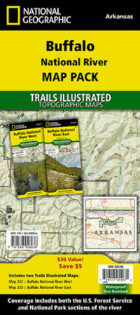
National Geographic Maps - Trails Illustrated
Buffalo National River Map Pack Bundle National Geographic Trails Illustrated Map
National Geographic 01-01-2019. 2019. map. Used: Good. 4.33x0.24x9.06. Buy with confidence. Excellent Customer Service & Return policy. National Geographic unknown
Bookseller reference : SONG1566958938 ISBN : 1566958938 9781566958936
|
|
|
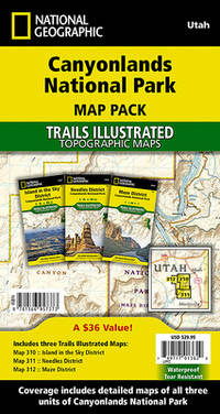
National Geographic Maps - Trails Illustrated
Canyonlands National Park Map Pack Bundle National Geographic Trails Illustrated Map
National Geographic 2023-01-01. 2023. map. New. 4.00x0.50x7.50. Buy with confidence. Excellent Customer Service & Return policy. National Geographic unknown
Bookseller reference : DADAX1566957370 ISBN : 1566957370 9781566957373
|
|
|
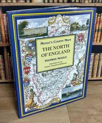
THOMAS MOULE'S COUNTY MAPS
The North of England : Moule's County Maps. With 19 full colour illustrations & maps : 12 County Maps & 7 Town Plans. Introduced by Ashley Baynton-Williams
Bracken Books London 1994. Hardcover. Good Condition/Good Condition. 48 pages with 19 colour maps & plans 22 x 29 cms each with text to the rear. Publisher's original blue boards spine with gilt lettering and dustwrapper. All in good condition with mildly worn dustwrappers. The maps used in this edition appeared originally in Thomas Moule's English Counties Delineated 1830-36. The exquisite Victorian maps depicting England's counties and cities presented in a large format are the work of the esteemed British cartographer Thomas Moule. Thomas Moule is celebrated as one of the premier mapmakers of the Victorian era and is recognized as a true successor to John Speed in the annals of British cartography. His meticulously crafted maps of counties and cities serve as a detailed historical record of 19th-century England. Initially released in collectible segments from 1830 to 1837 these maps were later compiled into the comprehensive two-volume work titled The English Counties Delineated. Moule honored the antiquity and heritage of each county by incorporating pastoral and monument views within the maps all elegantly framed by cartouches festoons and architectural embellishments in various historical styles. The book£££s introduction outlines Moule£££s career as a writer and antiquarian situating his renowned maps within the context of the technical cartographic advancements of his time. It explores the diverse artistic and cultural influences reflected in Moule£££s work where he merges precise cartography with ornate architectural frames and evocative Romantic pastoral scenes of the England he cherished. However beneath this portrayal of antiquity lies the influence of the British Industrial Revolution. Moule£££s maps are significantly shaped by the pioneering efforts of the Ordnance Survey and document the relentless expansion of major cities and the rapid proliferation of railways. Size: 23.5 x 29.5 cms. Multiple copies available this title. Quantity Available: 6. Category: Varied Books; Featured Items; Hardback Books; ISBN: 185891194X. ISBN/EAN: 9781858911946. Inventory No: 373256. This item may require more postage than the rates shown for delivery outside the UK. If extra postage is required we will contact you before processing your order and you will be given the details and option to decline the extra cost. 9781858911946 Bracken Books hardcover
Bookseller reference : 373256 ISBN : 185891194X 9781858911946
|
|
|
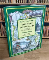
THOMAS MOULE'S COUNTY MAPS
The West of England : Moule's County Maps. Including the West Midlands. With 19 full colour illustrations & maps : 17 County Maps & 2 Town Plans. Introduced by Ashley Baynton-Williams
Bracken Books London 1994. Hardcover. Good Condition/Good Condition. 48 pages with 19 colour maps & plans 22 x 29 cms each with text to the rear. Publisher's original green boards spine with gilt lettering and dustwrapper. All in good condition with mildly worn dustwrappers. The maps used in this edition appeared originally in Thomas Moule's English Counties Delineated 1830-36. The exquisite Victorian maps depicting England's counties and cities presented in a large format are the work of the esteemed British cartographer Thomas Moule. Thomas Moule is celebrated as one of the premier mapmakers of the Victorian era and is recognized as a true successor to John Speed in the annals of British cartography. His meticulously crafted maps of counties and cities serve as a detailed historical record of 19th-century England. Initially released in collectible segments from 1830 to 1837 these maps were later compiled into the comprehensive two-volume work titled The English Counties Delineated. Moule honored the antiquity and heritage of each county by incorporating pastoral and monument views within the maps all elegantly framed by cartouches festoons and architectural embellishments in various historical styles. The book£££s introduction outlines Moule£££s career as a writer and antiquarian situating his renowned maps within the context of the technical cartographic advancements of his time. It explores the diverse artistic and cultural influences reflected in Moule£££s work where he merges precise cartography with ornate architectural frames and evocative Romantic pastoral scenes of the England he cherished. However beneath this portrayal of antiquity lies the influence of the British Industrial Revolution. Moule£££s maps are significantly shaped by the pioneering efforts of the Ordnance Survey and document the relentless expansion of major cities and the rapid proliferation of railways. Size: 23.5 x 29.5 cms. Multiple copies available this title. Quantity Available: 2. Category: Varied Books; Featured Items; Hardback Books; ISBN: 185891194X. ISBN/EAN: 9781858911946. Inventory No: 373257. This item may require more postage than the rates shown for delivery outside the UK. If extra postage is required we will contact you before processing your order and you will be given the details and option to decline the extra cost. 9781858911946 Bracken Books hardcover
Bookseller reference : 373257 ISBN : 185891194X 9781858911946
|
|
|
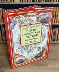
THOMAS MOULE'S COUNTY MAPS
The East & South-East of England : Moule's County Maps. With 19 full colour illustrations & maps : 15 County Maps & 4 Town Plans. Introduced by Ashley Baynton-Williams
Bracken Books London 1994. Hardcover. Good Condition/Good Condition. 48 pages with 19 colour maps & plans 22 x 29 cms each with text to the rear. Publisher's original red boards spine with gilt lettering and dustwrapper. All in good condition with mildly worn dustwrappers. The maps used in this edition appeared originally in Thomas Moule's English Counties Delineated 1830-36. The exquisite Victorian maps depicting England's counties and cities presented in a large format are the work of the esteemed British cartographer Thomas Moule. Thomas Moule is celebrated as one of the premier mapmakers of the Victorian era and is recognized as a true successor to John Speed in the annals of British cartography. His meticulously crafted maps of counties and cities serve as a detailed historical record of 19th-century England. Initially released in collectible segments from 1830 to 1837 these maps were later compiled into the comprehensive two-volume work titled The English Counties Delineated. Moule honored the antiquity and heritage of each county by incorporating pastoral and monument views within the maps all elegantly framed by cartouches festoons and architectural embellishments in various historical styles. The book£££s introduction outlines Moule£££s career as a writer and antiquarian situating his renowned maps within the context of the technical cartographic advancements of his time. It explores the diverse artistic and cultural influences reflected in Moule£££s work where he merges precise cartography with ornate architectural frames and evocative Romantic pastoral scenes of the England he cherished. However beneath this portrayal of antiquity lies the influence of the British Industrial Revolution. Moule£££s maps are significantly shaped by the pioneering efforts of the Ordnance Survey and document the relentless expansion of major cities and the rapid proliferation of railways. Size: 23.5 x 29.5 cms. Multiple copies available this title. Quantity Available: 3. Category: Varied Books; Featured Items; Hardback Books; ISBN: 185891194X. ISBN/EAN: 9781858911946. Inventory No: 373258. This item may require more postage than the rates shown for delivery outside the UK. If extra postage is required we will contact you before processing your order and you will be given the details and option to decline the extra cost. 9781858911946 Bracken Books hardcover
Bookseller reference : 373258 ISBN : 185891194X 9781858911946
|
|
|
Text And Maps By William Henry Burt
A Field Guide To The Mammals
Houghton Mifflin Co. 1952. First Edition. Hardcover. Very Good Light Wear At Extremities. 12mo. B & W And Color Plates Houghton Mifflin Co. hardcover
Bookseller reference : 41305
|
|
|
Collins Maps
Collins World Atlas: Paperback Edition
Collins 03/04/2021. 13th edition. Paperback. Used; Very Good. WE SHIP WITHIN 24 HRS FROM LONDON UK 98% OF OUR ORDERS ARE RECEIVED WITHIN 7-10 DAYS. We believe you will be completely satisfied with our quick and reliable service. All orders are dispatched as swiftly as possible! Buy with confidence! Greener Books. Collins paperback
Bookseller reference : 4895196 ISBN : 0008320411 9780008320416

|
|
|
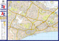
A-Z Maps
Cheltenham A-Z Pocket Street Map
Sheet map folded. New. New Book; Fast Shipping from UK; Not signed; Not First Edition; Navigate your way around Cheltenham with detailed street maps from A-Z unknown
Bookseller reference : ria9780008725495_inp ISBN : 0008725497 9780008725495
|
|
|
A-Z Maps
Bournemouth A-Z Pocket Street Map
Sheet map folded. New. New Book; Fast Shipping from UK; Not signed; Not First Edition; Navigate your way around Bournemouth with detailed street maps from A-Z unknown
Bookseller reference : ria9780008725471_inp ISBN : 0008725470 9780008725471
|
|
|
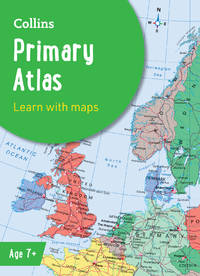
Maps, Collins,
Collins Primary Atlas
new. unknown
Bookseller reference : 47611503-n ISBN : 000871651x 9780008716516
|
|
|
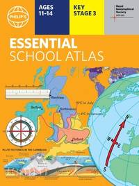
Philip's Maps (Author)
Philip's RGS Essential School Atlas: Paperback edition Philip's World Atlas
new. unknown
Bookseller reference : 48313796-n ISBN : 1849076952 9781849076951
|
|
|
Maps, Blue Planet Surf
The Essential Surfing NICARAGUA Guide & Surf Map Set
new. unknown
Bookseller reference : 9641564-n ISBN : 1450537871 9781450537872

|
|
|
Maps, Blue Planet Surf
The Essential Surfing NICARAGUA Guide & Surf Map Set
like new. unknown
Bookseller reference : 9641564 ISBN : 1450537871 9781450537872
|
|
|
A�Z maps,Compton-Davies, Ruby,Ankcorn, Robert
A-Z Birmingham Hidden Walks: Discover 20 routes in and around the city
like new. unknown
Bookseller reference : 42704917 ISBN : 0008496307 9780008496302

|
|
|
National Parks Uk Collins Maps
South Downs National Park Pocket Map
like new. unknown
Bookseller reference : 41621610 ISBN : 0008439206 9780008439200

|
|
|
Collins Maps
Munros and Corbetts Pocket Map: Discover Scotlandâs highest peaks
like new. unknown
Bookseller reference : 43577734 ISBN : 0008520623 9780008520625
|
|
|
Philip's Maps
Philip's Local Explorer Street Atlas Bristol and Bath: Spiral Edition Philip's Street Atlas
new. unknown
Bookseller reference : 44312523-n ISBN : 1849076022 9781849076029
|
|
|
Philip's Maps
Philip's Caribbean Atlas for Secondary Schools: 8th Edition Philip's World Atlas
new. unknown
Bookseller reference : 45514747-n ISBN : 1849076472 9781849076470
|
|
|
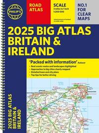
Philip's Maps
2025 Philip's Big Road Atlas of Britain & Ireland: A3 Spiral Binding Philip's Road Atlases
new. unknown
Bookseller reference : 47330571-n ISBN : 1849076642 9781849076647
|
|
|
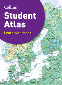
Maps, Collins,
Collins Student Atlas
new. unknown
Bookseller reference : 46142444-n ISBN : 0008652856 9780008652852
|
|
|
Philip's Maps
Philip's Navigator Trucker's Britain: Spiral: Spiral Philip's Road Atlases
new. unknown
Bookseller reference : 44901327-n ISBN : 184907612x 9781849076128

|
|
|
Philip's Maps
Philip's Street Atlas Navigator Lincolnshire: Spiral Edition
new. unknown
Bookseller reference : 44312516-n ISBN : 1849075719 9781849075718
|
|
|
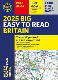
Philip's Maps
2025 Philip's Big Easy to Read Britain Road Atlas: A3 Paperback Philip's Road Atlases
new. unknown
Bookseller reference : 47113080-n ISBN : 1849076618 9781849076616
|
|
|
Philip's Maps
2025 Philip's Easy to Read Road Atlas of Britain: A4 Spiral binding Philip's Road Atlases
new. unknown
Bookseller reference : 47113083-n ISBN : 1849076669 9781849076661

|
|
|
Philip's Maps
Philip's Local Explorer Street Atlas Nottinghamshire: Spiral Edition Philip's Street Atlas
new. unknown
Bookseller reference : 45750440-n ISBN : 1849076421 9781849076425
|
|
|
Philip's Maps
Philip's Local Explorer Street Atlas Wiltshire and Swindon: Spiral Edition Philip's Street Atlas
new. unknown
Bookseller reference : 45750834-n ISBN : 1849076405 9781849076401
|
|
|
Philip's Maps
Philip's Local Explorer Street Atlas Norfolk: Spiral Edition Philip's Street Atlas
new. unknown
Bookseller reference : 46030398-n ISBN : 1849076448 9781849076449
|
|
|
Harvey Maps
Snowdonia Central Superwalker - 1:25000 map: Porthmadog Rhinog Fawr Superwalker XT25
new. unknown
Bookseller reference : 47501673-n ISBN : 1851376801 9781851376803
|
|
|
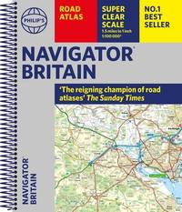
Philip's Maps
Philip's Navigator Britain: Spiral Philip's Road Atlases
new. unknown
Bookseller reference : 44567736-n ISBN : 1849076138 9781849076135
|
|
|
Philip's Maps
2025 Philip's Easy to Read Multiscale Road Atlas Europe: A4 Spiral binding Philip's Road Atlases
new. unknown
Bookseller reference : 47113079-n ISBN : 184907660x 9781849076609

|
|
|
Philip's Maps
Philip's Local Explorer Street Atlas Cheshire: Spiral edition Philip's Street Atlas
new. unknown
Bookseller reference : 44312521-n ISBN : 1849076006 9781849076005
|
|
 Receive by email
 Download as PDF document
 RSS feed


