4 361 résultats
Engraved map (33.5 x 44 cm). Matted. Engraved map of the Arabian peninsula and southern Iran, with place names corrected by “a scientist very educated in the Arab language”. Al Ankary 210.
Small 8vo. (8), 564, (4) pp. With 2 folding engraved maps and 8 folding engr. plates; several woodcuts in the text. Wants the portrait found in some copies. Contemporary dark brown full calf with traces of oxydized giltstamping to spine and gilt leading edges. First Amsterdam reprint: Taviernier's description of the Ottoman Imperial Seraglio - his first published work, which had appeared separately as early as 1675 - here forms the final part of his "Recueil de plusieurs relations et traitez singuliers & curieux", an independent publication which was, from 1679 onwards, appended to the author's "Six voyages en Turquie, en Perse, et aux Indes" (thus ultimately forming that collection's third and final volume). It was this volume, containing Tavernier's studies in commercial politics, that made the author's travels widely known. The fine maps show Japan and Tonquin, the plates depict costumes, a theatre performance, temples, and various processions. A woodcut in the Seraglio section gives the Islamic profession of faith, the Shahada, in Arabic script. "Tavernier spent eleven months in Constantinople before setting out on his first journey. He joined a caravan for Persia in 1638 and, between 1643 and 1668, made six voyages to Persia, India, the East Indies and Japan. During his travels he amassed a large collection of diamonds and jewels. His successful commercial enterprise was recognised by Louis XIV and he was granted a patent of nobility for his contribution to the establishment of French trade in Asia. It was Tavernier who indicated the trade routes to the East and made it possible for others to follow him. According to Brunet, the 'Recueil' appears with all editions of the 'Six Voyages' printed after 1679" (Atabey). "It appears that much of his information on the Seraglio was obtained from two former employees of the Sultan, one a Frenchman, the other an Italian" (Blackmer). - Binding rubbed but tight; a tear to one map repaired. Slight browning throughout due to paper. A good copy. Graesse VI/2, 43. Goldsmiths' 2283. Willems 1937. Atabey 1201. Cf. Cordier, BJ 393. Laures 525.
12mo. (20) pp., 1 blank leaf, 445, (5) pp., 3 blank leaves. Title printed in red and black. With engraved frontispiece. - (Bound with) II: Andrés, Juan. Des für 200 Jahren bekehrten Doctoris, Professoris und Praedicatoris der Muhammedischen Lehre, Johannis Andreae Mauri, nachdenckliches Buch, gegen den Mahomet und die Mahomedische falsche Lehre; von newen in Teutscher Sprache außgefertiget durch [Rudolf] Capell. Hamburg, Georg Wulff, 1685. (54), 218 pp., final blank. With engraved frontispiece. Contemporary vellum with handwritten spine title. Rare, early German edition of Tavernier's (1605-89) account of the Ottoman court drawn from his own observations. "The author's journey began in 1630. He went on a mission to Constantinople in 1636, or earlier. He states in the preface that much of his information regarding the seraglio was obtained from two former exployees of the Sultan, one a Frenchman, the other an italian, each of whom had served for many years" (Weber). The author also describes Ottoman ranks and court offices, as well as Ottoman coinage. - Bound after this is a very rare German edition of the widely received account of Islam provided by Juan Andrés, a converted Moor. First published in Spanish in 1515, it achieved immediate fame and was translated into many languages. "A crude anti-Islamic pamphlet by the Moor Abdallah, who took the Christian name of Johannes Andreas (Juan Andrés). The quotations from the Qur'an are often wildly distorted, and their interpretation biased - a fact which was even praised in the Paris edition of 1574" (cf. Göllner). - Some red underlining to Tavernier; some browning, but very well preserved. From the library of the Viennese collector Werner Habel, with his ownership stamp to front pastedown. His note of acquisition from 1976 is loosely inserted. I: VD 17, 39:126588G. Cf. Weber 270 ff. (other eds.), Graesse IV, 43 (1675 French ed.). Not in Cox. - II: VD 17, 23:286870C. Chauvin XII, p. 23, sub no. 86. Cf. Göllner I, 73 (1515 first ed.).
8vo. 46, (2) pp. Arabic text. Original printed wrappers, stapled. First edition. The second of two rare pamphlets published by the Iraqi government, opposing the independence of Kuwait. The first pamphlet, published in English and Arabic, outlined Kuwait's historical connection to Iraq and analysed its "imperialist relations" with Britain. This second one, in Arabic throughout, prints the minutes of the Political Affairs Committee of the Arab League, which met in Cairo on 20 July 1961 to consider Kuwait's request to join the League. - Kuwait emerged as an independent state in June 1961, after sixty-two years as a British protectorate. With a new constitution, it held its first parliamentary elections in 1963, thereby becoming the first Arab state in the Gulf to establish a parliament. Such political developments, married with growing wealth and modernisations in health, culture and finance, helped to make Kuwait the most prosperous state in the Arabian Peninsula. - The Iraqi government argued that the move toward independence was a continuation of Kuwait's relationship with Britain, albeit under a new guise. Furthermore, they felt that the historical links between Iraq and Kuwait entitled the former to control over the latter and, one suspects, a share of its growing wealth. This position, partly detailed in the pamphlet, led to a point of crisis, with Iraq threatening invasion. To the relief of Kuwait, the Iraqis were eventually deterred by the Arab League's promise of military opposition. - Wrappers a little dusty, two thick black lines to upper wrapper, seemingly erasing stamp, another stamp partially visible to lower wrapper (most likely a bookseller's name and address, "Baghdad" is legible). Interior clean and bright. - Rare: LibraryHub locates one copy in the UK at the British Library; OCLC locates copies in Harvard, the University of Toronto, and the NYU Abu Dhabi. OCLC 219629380.
4to. (8), 176 pp. With woodcut printer's device on title page and several woodcut headpieces and initials. 18th century full vellum with giltstamped red spine label. In spite of the subtitle ("nuovamente mandate in luce"), this is the first edition of Ulloa's history of the Ottoman wars in Hungary, including an account of the 1566 Siege of Szigetvár. Though the battle resulted in an Ottoman victory, it halted the Ottoman advance on Vienna that year, and Vienna was not threatened again until 1683. "The Castilian-born Alfonso Ulloa was entrusted with various diplomatic missions by Emperor Maximilian as well as by King Philip II and thus had a first-hand knowledge of the events of the years 1566-1569. Disregarding the frequently panegyrical tone of the account, the book may still be used as a valuable historical source" (Göllner). Apponyi, on the other hand, cautions that "this is nothing but a reprint of Pietro Bizarri's 'Historia', published the previous year [... The book nothing to do with Ulloa's account of the events at Sziget published in his own 'Comentarios' in 1569: apparently, he found it easier to rip off Bizarri than himself ...] Ulloa has the nerve to present this shameless piece of plagiarism to his patron with the most unctuous and swaggering phrases [...] Cautiously, Ulloa shied away only from copying certain personal accounts of Bizarri's, or rather from presenting these experiences of Bizarri's as his own; everything else is reproduced verbatim". - Title page shows some brownstaining, otherwise a clean copy in a pretty contemporary binding. Formerly in the collection of the Marquess of Bute with the family's engraved armorial bookplate (from the library of Luton House, Bedfordshire; pre-1845) on the pastedown. Edit 16, CNCE 38245. Adams U 40. BM-STC Italian 704. Apponyi I, 437. Göllner I, 1271.
1562230:325 mm. Engraved map. "A blown-up copy of the map designed by Gastaldi in 1548" (Al Ankary). The Gastaldi map "was the first modern map of the Arabian peninsula"; for the first time it "clearly shows the island of Bahrain and Qatar" (ibid.). Al Ankary 136.Tibbetts 27. Cf. Sultan Bin Muhammad Al-Qasimi 19 (the small version only).
8vo. (4), 135, (3) pp. With 3 folding tables and 1 engraved plate. Later blue wrappers. Only edition of this introduction to Arabic, written by the Comte de Volney (1757-1820) as history professor at the newly-founded École normale, immediately after the end of the Terreur and his release from prison following the fall of Robespierre. In spite of its wide-ranging title, the book comprises essentially an Arabic grammar and a collection of Arabic proverbs; the long introductory chapter has been hailed a model of style. Volney had learned Arabic in 1782 in preparation of a long journey through Egypt and Syria. The work displays his ingenious method of simplifying the study of Arabic, Persian and Turkish by transliterating the alphabets into European characters. The tables give the Arabic alphabet, the conjugation of regular verbs, and instructions on how to write Arabic letters by hand, as well as the Arabic alphabet in European characters intended for merchants travelling to Asia and Africa. With a section of Arabian proverbs included as samples. - Pages 30-31 unopened. A good copy of this important work, untrimmed as issued. Gay 3429. Brunet V, 1351. Cioranescu 663767. Monglond III, 481. OCLC 21978700.
Oblong 8vo. 53 printed photographs on 27 ff. printed in sepia to rectos only, contained in original printed card covers with oval window. A remarkable series of photographs of the peoples and places of South Persia (modern Iran and Iraq). The first leaf - which contains the title with a small portrait of a street seller - is followed by four leaves showing views of the Abadan Refinery. The remaining leaves show scenes in Mohammerah (now Khorramshahr), Shatt-el-Arab, Dizful (Dezful), Ahwaz (Ahvaz), as well as artistic views of the coast ("Moonlight on the Shatt-el-Arab", "Sunset in the Gulf"). There are also further portraits of street sellers and other local people (dervish, snake charmer, barber). The booklet closes with a view of the "Pumping Station, Tembi" which served the Abadan refinery, "The road up to the oil fields", and a view of the Ctesiphon Arch. An uncommon and nicely produced view-book of the area. - Minor spotting to first leaf, creasing to upper wrapper but contents generally in good, clean condition.
1900388 x 470 mm. Framed and glazed. Needlepoint picture after Théodore Géricault.
8vo. XVI, 167, (17) pp. Contemporary half calf with handwritten spine label. First edition. Selections from Arabic works on medicine and natural science in the original language appended with separate title page (in Arabic): extracts from the "Kitab tahdib al-asma", by Abu Zakariya Yahya al-Nawawi, "Kitab 'uyun alanba' fi tabaqat al-atibba'", by Ibn Abi Usaybi'a, and "Tabaqat as-safiiyya", by Ibn Suhba. - The German orientalist H. F. Wüstenfeld (1808-99), considered one of the greatest literary historians of Arabic, studied theology and oriental languages at Göttingen and Berlin. He taught at Göttingen, becoming a professor there (1842-90), and published many important Arabic texts and valuable works on Arabic history. - Binding somewhat rubbed; some foxing. Old handwritten pencil notes to flyleaf; handwritten ownership to title. A good copy. Macro 2345. Ibrahim-Hilmy II, 342.
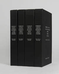
réf. 122002Minneapolis East View 2026. . 4 vols 8vo 25.5 x 16.5; publisher's black cloth lettered white to boards and spines a fine copy. A comprehensive collection of annual reports produced by the British Foreign Office concerning the major regions of Arabia often intended as internal circulars and never for direct publication. Minneapolis, East View, 2026. hardcover
Large 8vo. (12), 269, (3) pp. With 35 plates and numerous illustrations in text. Modern red half sheepskin, with the original publisher's printed wrappers bound in. Rare first and only edition of a work on falconry, followed by a short treatise on cormorant fishing by Alfred Belvallette, "well known in France as a skilful falconer, and he writes with a thorough knowledge of his subject [...] French falconers apply the term fauconnerie only to flights with the long-winged hawks (Peregrine, Merlin, Hobby, and Jerfalcon), flights with the short-winged Goshawk (autour) and Sparrow-hawk (épervier) coming under the expressive and very convenient term 'autourserie'" (Harting). The work partly contains original illustrations, including many photographs of falconers in action, but also copies after Schlegel and others. - Belvallette is best known for his earlier work "Traité d'autourserie" (1887), the present work includes this topic as well, but is not included in Bibl. accipitraria or Schwerdt. - With only a couple of spots, otherwise in very good condition. Thiebaud 66. Cf. Harting 219; Schwerdt I, 59. WorldCat (9 copies).
Engraved map, outline colour (560 x 450 mm). Decorative map of the Turkish Empire, showing the Ottoman territories in the Balkans, Anatolia, Levant, Arabia and North Africa, published by Henricus Hondius in Atlas sive Cosmographicae Meditationes de Fabrica Mundi et Fabricati figura. The map has a decorative cartouche with the portrait of Ottoman Sultan Mahomet Turcorum Imperat 2. The English translation of the text (1636 edition) includes observations such as "The Countrie is for the most part fruitfull in graine, as wheate, barlie, oats, winter wheate, beanes, pease, and all manner of pulse. It aboundeth in rice, flaxe and cottons. They have vines, whose fruit they make use of after divers manners. The Christians make wine of them, & the Turcks prepare a kind of sweete meate, by mingling honey and grapes together, which seemeth allwayes fresh, both to the sight & tast, this they call Vsum Turssi (sic)." Tibbetts 63. Al Ankary 178. Al-Qasimi 50.
8vo. XXII, 290, 8 pp. Contemporary full blue cloth with remains of a printed spine title. First edition. Entitled "The Book of Wonder, or the Summary of News of the Maghreb", this is the best-known work of the Moroccan historian 'Abd al-Wahid (1185-1250): a personal and at the same time neutral account of Almohad rule from its foundation to the 13th century, but also of the preceding dynasty of the Almoravids, with a summary of Al-Andalus history from the Muslim conquest until 1224. The book is written in a lighthearted spirit with many anecdotes; 'Abd al-Wahid explained that his intention was to inform and entertain the students in a summarized way since academic history books tend to be overly lengthy which can sometimes bore the reader. The work also contains valuable information about 'Abd al-Wahid's contemporary Ibn Rushd (Averroes), whom he may have known personally, as well as information directly taken from the Almohad archives, various princes and accounts of events that the author witnessed. A number of details point to Egypt as the place of writing, and the author himself states that he completed the work on 15 July 1224. Dozy's important edition of the Leyden MS. was republished in 1881. - Corners and spine-ends a little bumped. Occasional quite insignificant foxing; uncut and untrimmed as issued. Provenance: removed from the library of Carberry Tower, the Scottish castle mansion owned by the Elphinstone family from the 1860s to the 1960s, with bookplate and shelfmark to front pastedown. GAL I, 322. For Dozy's editions of historical texts on the history of Muslim Spain see Fück, p. 182.
8vo. (2), L, 312, (2) pp. With several maps and plates. Original cloth. "The Persian Gulf Pilot contains sailing directions for the Persian gulf and the approaches thereto, from Ras al Hadd, in the south-west, to Cape Monze, in the East". - Also includes copious information on politics, population, languages, trade, currencies, pearl fishery, meteorological information (climate, winds, weather, temperature, humidity), as well as currents, tides, communications and other miscellaneous information. - Binding rubbed and faded. Only two copies in auction records of the past decades (Peter Hopkirk's copy fetching £1,300 at Sotheby's, Oct 14, 1998, lot 1043). Hydrographic Office Publication 158. OCLC 709448977. Cf. Wilson 171.
Folio (212 x 333 mm). (2), XIII, 91 pp. With 29 full-page plates (of which 20 folding) including dozens of coloured maps, as well as a very large folding "Map of the world showing existing and proposed air transport routes" housed in a custom pocket on the inside rear board, as issued. Original printed grey boards with blue cloth spine. Sole edition of this large-format, pivotal early document in the development of international air travel - complete with all 29 plates and the often-lacking loose map. The principal concern of the British during this period was accelerating air transport between the vast reaches of their empire - and chief among these was the lengthy journey to India, via the Middle East. As noted on p. 5, the maximum range of commercial aircraft in 1926 was a mere 400 miles; perhaps partly for this reason, the existing and proposed air routes include numerous stops for refueling in the oil-rich regions of Syria, Iraq, and Iran. - The stated aim of the Air Ministry was in fact to reduce the journey to India to just 5 days (p. VI), and although bold proposals are put forward and illustrated for giant "airships" with a range of 4,000 miles, the then-current technology limited aircraft to a designated route along the northern coast of the Arabian Gulf. Facing the challenge of "the extreme heat and the height of the Arabian Plateau, both of which tend to reduce the load with which an aeroplane can rise from the ground" (p. 9), the route is amply illustrated on numerous folding maps, from Cairo via Gaza, Rutbah Wells (Iraq), Baghdad, Basra, Bushire, Bandar Abbas, Chahbari, Pasni, Karachi, Hyderabad, etc. - Other chapters cover fascinating proposals for "major air routes" between Ottawa, London, and Kingston, Jamaica; "the use of wireless in air traffic communications" (p. 62); early air routes in Australia and the United States; and so on. The plates include designs for proposed experimental "airships"; photographs of early airports, and maps of meterological phenomena. Particularly interesting is the "Map Showing Areas in Which Main Imperial Airship Routes Will Probably Develop" (facing p. 74), which indicates that alongside the Transatlantic route, the coasts of the Arabian Gulf (but not the interior) as well as the coasts of Africa will be the next targets of development.
4to. 1 p. on bifolium. In Arabic, to General Viala Charon, French governor in Algeria. Includes contemporary French translation.
Lithographed map, ca. 99 x 137 cm. Scale 1:1,000,000, Conformal Conic Projection. Rare U.S. Air Force aeronautical chart of the Arabian Gulf detailing Saudi Arabia with Al Hasa Oasis, the Qatar Peninsula, Bahrein, parts of Kuwait, Iraq and Iran, as well as the Saudi-Kuwaiti and Saudi-Iraqi neutral zones. Other details include Tapline road, Kuwait road, geological features like the Dibdiba gravel plains, and the Rub al-Khali desert. The most prominent labelled cities include Riyadh, Doha, Kuwait, Bushire and Shiraz. - The map was prepared by the USAF Aeronautical Chart Service with the 1950 copyright belonging to Standard Oil Company. SOC subsequently licensed their copyright to Aramco. - With a single fold. Somewhat toned. Several larger tears to lower margin; a tear in right margin repaired with old adhesive tape.
A total of 10 separately catalogued items: a personal collection of 5 membership cards of golf clubs, country clubs and women's groups, one golf score card and the Aramco Golf Banquet programme, a set of 7 programmes of the Protestant Fellowship, 2 programmes of a choir and theatre group, 2 membership cards of the Ras Tanura Golf Association, 2 autograph Christmas and birthday cards, a calling card, 2 identification cards, and a sew-on patch. Private material collected by the Aramco employees Orlin Orace and Velma Thomas during their years in Ras Tanura. The collection portrays the couple as avid golf enthusiasts, including their membership cards for several clubs of the Ras Tanura Golf Association as well as Velma's score card. Perhaps the most uncommon item is a sew-on patch of the Golf Association: woven with gold, blue and black thread, it shows two camels wandering the Saudi Arabian desert surrounded by a set of golf clubs, an oil rig, and a palmtree. - The Thomas family were active members not only of the golf scene, but also of the Protestant Fellowship; their archive further comprises several programmes for Sunday School, Vacation Bible School, and Christmas service. - 2 autograph Christmas and birthday cards addressed to Mrs. Honeycutt in Tulsa, Oklahoma, signed by the Thomas family, document the expats cultivating their relationship to their native home. - The remaining items include an insurance ID verifying Thomas's claim to have medical expenses covered under the Aramco medical payment plan, a permit to use retail services in the Ras Tanura Camp, as well as the programmes of a choir and theatre performance in Ras Tanura. - An intriguing set documenting the diverse activities of Aramco expats in Saudi Arabia. Detailed list available on request.
4to. 106, 22 ff. (as numbered; some leaves numbered with 'a' numbers according to preceding leaf, per standard industry practice). Published as a mimeographed typescript with inset illustrations, many folding. Bound in original wrappers with metal split pin fasteners. Second revised edition. A very extensive report supplied to Aramco regarding the Convair CV-340, a passenger jet designed largely for airlines like United, but quite popular in Saudi Arabia during the first decades of Saudi passenger air service. - The early 1950s saw the dawn of what would become Saudi Arabian Airlines, precipitated in part by the gift of a Douglas DC-3 passenger jet from U.S. President Roosevelt to King Ibn Saud in 1945. It would be the DC-3 and the CV-340 which would comprise the first fleets of passenger planes in Saudi Arabia. That Aramco, a large regional employer, might be interested in the CV-340 is thus understandable; in fact, both planes are remembered by Aramco employees from the 1950s and 1960s - and especially by their children, who were often sent to prep schools in cities like Rome, but flew home on DC-3s and CV-340s to Aramco installations like Dhahran with their peers for holidays. - The CV-340 was developed by Consolidated Vultee (later Convair) from the earlier CV-240, but was newer and larger; the first flight test took place on 5 October 1951. The CV-340 seated at total of 44 passengers. In all, 209 aircraft of this type were sold to airlines but 37 went to private operators, potentially including those interested in purchase at Aramco and more generally in Saudi Arabia and along the Gulf. In extensive text and diagrams, every aspect of the engineering and design of the plane is presented, from the new layout of the tailfin to the shocks in the landing gear to the fire extinguishing system. - A touch of wear, otherwise a well-preserved example of a rare publication produced in a very limited number of copies for promotional and reference use only.
3 typed letters signed and 1 autograph letter, a passport, and an air freight manifest. Compelling archive of the Aramco employee Paul Schwarzenau (1916-92), who joined the Aramco "family" at Dhahran around April 1952. The archive comprises three letters to his mother describing his life in the Middle East, praising his new job with Aramco: "How lucky can i get? All this and a salary too! Ah yes, this is real living although i still can't understand why it should happen to a bum like me!". The remaining correspondence is written in a slightly more critical tone, speaking of an invasion of locusts and the difficulties raised by the language barrier, as well as working obligations during the month of Ramadan, suggesting "the company should abolish all daytime work during this month but of course it is all a big question of $$$$$$'s and the oil has to be kept moving regardless of any attempts, man-made or god-made, to interrupt the flow". - The passport is packed with entrance visa stamps of his trips to Aramco facilities in the Middle East. It also documents a change of name from "Schwarzenau" to "Stiehl". - In addition, the set includes an air freight manifest for a box of personal effects Schwarzenau had shipped from Dhahran to New York. The document includes a customs clearance authorization as well as a specification of the contents of the box, which contained 4 prayer rugs, 12 towels, and 5 bed sheets. - A unique ensemble. Detailed list available on request.
4to. 20, (3) pp., final blank page. With a woodcut illustration. - (Bound with) II: The same. Oran conquistado, e defendido, relaçam historica [...] Parte II. Ibid., 1733. 16 pp. Later full vellum. First editions. Both separately published parts of this rare work on the Spanish expedition against Muslim Oran. After a survey of the history and geography of Oran (in modern Algeria), the author describes the preparations for the expedition to recapture the city, enumerates the Spanish leaders, and gives details of the Spanish naval and military attacks on sites in and around Oran in June and July 1732. The captain-general of the expedition was José Carrillo de Albornoz, first Duke of Montemar, who had fought in the War of the Spanish Succession and the War of the Quadruple Alliance; at this time he was viceroy of Sicily. Facing p. 20 is the plan of battle for the Spanish forces. The woodcut on the verso shows the harbour at Oran, the town, and the half-dozen fortresses surrounding it, as well as the position of the Spanish navy during the battle. The final leaf has the key to the map on its recto, with the verso blank. Freire de Monterroyo Mascarenhas explains in the dedication that he compiled this account from many shorter ones, because the public was eager to learn about the reconquest. Oran, which was in Spanish hands since 1509, had been captured by the Turks in 1708, while Spain was preoccupied with the War of the Spanish Succession. Spain then held the city from 1732 until 1792, when it suffered a massively destructive earthquake and King Charles IV handed the city back to the Ottoman Empire. - First part uncut. Second part slightly wormed near the gutter. Occasional light brownstaining. The two parts are very rarely encountered together. Inocêncio IV, 348. Barbosa Machado II, 856. BGUC Misc. 3, 80.
8vo. X, 187, (1) pp. With frontispiece, 31 plates, 7 maps (3 in lower cover pocket), and 8 panoramas, mostly folding. Contemporary quarter calf over green cloth covers with giltstamped red spine labels. First edition. - The British-Indian Army's official account of the 1919-20 Waziristan campaign, marked "Confidential" on the title-page. The operations followed unrest that arose in the aftermath of the Third Anglo-Afghan War; they were conducted in the mountainous region of Waziristan (now in Pakistan) by British and Indian forces against the fiercely independent Waziri and Mahsud tribesmen that inhabited it. Since the 1870s, the British government agencies were assiduous in compiling internally published histories of their military frontier operations, with the intention of providing a "valuable guide" to such British commanders and policymakers as "might have future dealings with these turbulent neighbours" (as the Punjab Government phrased it in 1866). - Serial No. 1235 stamped to title-page. Occasional light marginal staining. A few edge flaws consistent with army use, repaired by a contemporary owner. In all a well-preserved, complete copy. OCLC 11497145. Catalogue No. C.W. 4 - Case No. 8987 N.S.
Oblong folio (240 x 166 mm). 20 ff. 25 silver gelatin photographs, one of which is laid in at the rear; each is roughly 90 x 140 mm. Contemporary textured brown cloth, saddle-stitched with tassel. A rare collection of photographs of the political actors of 1950s and 1960s Iraq and the Kurdistan Region, each set having been taken only a year before the revolutions of 1958 and 1968, respectively. The photographs have been collected here with handwritten captions in German, possibly by one of the German engineering technicians featured in one snapshot. The earlier photographs feature the royal family, including the crowds of spectators awaiting King Faisal in 1957, the banquet for the guests of King Faisal in Sulaymaniyah, and the visit of the Regent and Crown Prince of Iraq, Abd al-Ilah, to Sulaymaniyah in the wake of the flooding in Autumn of 1957. - The laid in photographic print is dated 1955 and titled "im Garten v. Naji Khedairy", featuring a nighttime snapshot, presumably of Khedairy, staring down the camera with a glass in hand. - The later photographs are from September of 1967, several months after the Six Days' War, and feature the political landscape once again on the brink of change: two photos of Iraqi Prime Minister Tahir Yahya in a pinstripe suit walking with leader of the Kurdistan Democratic Party Mustafa Barzani, another photo of Barzani walking alone; several shots Abdul Razzak, Mustafa Barzani, and Tahir Yahya seated together with refreshments, including one of Barzani and Yahya laughing together, another photograph of Barzani captioned "Der kurdische Führer im Gespräch mit einem irakischen Militär", several casual snapshots of the "Kurdische Delegation" relaxing between meetings, one of which features one woman in Western dress, and a snapshot of the Kurdish military headquarters in Quaradagh. - Altogether, a photographic record of the political leaders of the region during two tumultuous decades, and their meetings amid conflict. Well preserved.