ARABIAN GULF CARTOGRAPHYBiblio.com

4.438 resultados
1963ref. 153757London: Geographical Section General Staff 1963. Scarce charts of Bahrain and the Straits of Hormuz A rare and historically interesting pair of adjacent maps of the Arabian Gulf covering six degrees of longitude each the geographical area encompassing the whole of Qatar Bahrain and part of what was to become the United Arab Emirates Al-Hofuf being the major city in the Al-Ahsa Oasis Eastern Province Saudi Arabia; sixth and fifth editions respectively. Maps of the period issued by the GSGS Geographical Section General Staff use a 7-colour tint scale to distinguish altitude and a glossary that highlights towns of significance and other standout features which provided steady references for army personnel to aid navigation in the challenging conditions of the region. The Bander Abbas map was compiled by the US Army Map Service Corps of Engineers from a number of sources including USAF Aeronautical Approach Charts of 1951-55 and the US Geological Survey of the Arabian Peninsula 1958. The Hofuf chart is based inter alia on 512 Field Survey Royal Engineers charts 1942-4. WorldCat lists just three individual copies for Hofuf NG39 SUNY at Buffalo University of Notre Dame and Eastern Illinois University alongside four copies of Bandar Abbas NG40 University of Exeter University of Notre Dame Eastern Illinois University and University of South Florida. It should be noted that major national institutions - BL for example - will have holdings of these maps within the complete GSGS series. Most copies would be discarded on supersession making these an important record of cartographic progress in the region. Two two-colour printed maps 1:1000000 scale 690 x 610 & 750 x 610 mm respectively. Ex- libris stamp of Arizona State Library both stamped "superseded" in blank margin and "withdrawn" on verso some pencilled marginalia; both in excellent condition. unknown
1956ref. 153759London: Geographical Section General Staff 1956 & 1957. Scarce maps of Oman and south-east Arabia dating to the Jebel Akhdar War A pair of decidedly uncommon and impressively sized regional maps both second editions Muscat-Musira following the first of 1945 S. E. Arabia first published in 1956. The Muscat-Masira map drawn up by D Survey of the Ministry of Defence reaches as far north as Khaburah Oman on the coast south beyond Masirah Island and westward reaching beyond Lahus and Hadhi. It is based on several mappings including Bertram Thomas's map of Rub' al Khali the "Empty Quarter" 1931 the sand desert covering most of the southern third of the Arabian Peninsula Samuel Barrett Miles 1910 map of Oman and Captain F. F. Hunter's map of Arabia 1935 revision. The aeronautical chart goes into greater detail reaching beyond Sur in the North South to Masirah Island and Manadhif and West to Uruq ash Shaybah UAE; this was drawn up by No. 1 SPC.RE i.e. Survey Production Centre Royal Engineers and is based largely on the USAF Aeronautical Approach Charts 1956 and World Aeronautical Chart 563 1951. During the mid to late-1950s Britain was involved in a number of disputes in Oman perhaps the most serious involving the Imam Ghalib al-Hinai and his brother Talib bin Ali who led the Imamate's revolt against Sultan Said bin Taimur which resulted in the Jebel Akhdar or Oman War 1954-1959. In this the RAF played a leading role not least because aircraft could at the same time expedite oil exploration operations in the interior of Oman. Pembrokes light transport aircraft and heavier Avro Ansons from 1417 Communication Flight RAF carried out reconnaissance "and other tasks during this operation against the Imamate and were the first aircraft ever to land at Nizwa marked "Nazwa" on the chart on a roughly cleared strip which proved extremely hazardous for the pilots but which was later transformed into a passable airfield" Lee p. 22. The present chart has two pencilled lines radiating from Masira airfield one of which passes through Nizwa near which is marked the "approx. position" of an airstrip. The chart bear the proviso that they should "not be taken as an authority on names" and that "the alignment of all tracks is approximate". Users were also directed to update information and highlight errors which were to be directly sent to the Director of the Military Survey in the War Office. There are noticeable graphical variations between the chart and map as fitting their usage. Before the Second World War pilots flew using landmarks - such as train tracks or roads - as pointers which meant that they relied on perfect weather conditions. However technological advances in aviation alongside the use of radio for more accurate navigation meant that to a degree pilots could work in more challenging conditions. This meant that maps with their focus on terrain and details relevant from the perspective of ground troops would become irrelevant when observed from a plane's altitude. Therefore a number of countries started to produce charts highlighting key information by reducing the contour structure and focusing on key landmarks necessary for aviators. The Muscat-Masira map uses a five-colour tint scale to distinguish altitude includes a glossary and key the latter identifying towns given four categories of importance significant ruins geographical features such as mountains hills marshes saddles and passes rivers water holes and man-made features such as railways roads tracks telegraph lines pipelines and pumping stations mosques and temples; tribal and regional names are also given. However reflecting the simplification required by pilots the S. E. Arabia chart only uses fives tones to highlight land mountains paths and the sea. These maps intended for use in the field would have had a high rate of attrition; WorldCat locates just a handful of copies of the Muscat-Masira map whilst S.E. Arabia 4802 is well represented institutionally but decidedly uncommon on the market. Two colour printed maps the first 1: 1000000 scale 860 x 640 mm the second 1:500000 scale 1100 x 825 mm. Both with creases from old folds and some minor marginal splits and spots the second with pencil lines marking a flight route from Masira Island and a notation in the margin; both remain very good. Sir David Lee The RAF in the Mediterranean and Middle East 1945-71 1978. unknown
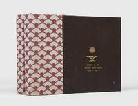
ref. 163098Jeddah: Kingdom of Saudi Arabia Ministry of Defense and Aviation; Lockheed Aircraft International 1983. The Saudi approach is unique Unrecorded institutionally and commercially this attractive set of albums celebrates Lockheed's role in augmenting Saudi Arabia's air traffic control systems both commercial and military over the period 1972-82. They comprise a total of 80 leaves covering summaries of developments "information flow" diagrams for Kaia Riyadh International Dhahran and Jeddah airports colour maps charts and photographs of facilities operatives and aircraft. Writing in Arabian Studies in 1976 aviation expert Elda I. Stifani notes: "By virtue of its geographical position and the strategic economic and political interests of both local and worldwide powers the Middle East plays a major role in civil aviation operations The Saudi approach is unique. No other country in the Arabian Peninsula has an equally determined and precise policy of national aviation development" Arabian Studies III p. 36. Interestingly he also notes that "Bahrain handles air traffic for all the UAA United Arabian Airlines Qatar part of Oman of Kuwait and of Saudi Arabia Dhahran". In March 1974 the Saudi airline Saudia ordered two of Lockheed's new TriStar airliners specially fitted with increased wing fuel tankage. By 1978 Saudia had increased its fleet of TriStars to thirteen. Provenance: presented to Clifford G. Fay of Lockheed Saudi Arabia 1980-82 with his name and dates of service on the front covers. Loosely inserted is a typed letter from Lockheed to Fay presenting the volumes and mentioning that they have been supplied by Joe Akers who was a Lockheed veteran with 28-years' experience at the company retiring as chairman in 1988 26 June 1983 Jeddah letterhead in English and Arabic. 2 vols landscape quarto 235 x 320 mm. With 80 sheets presented recto and verso in clear plastic pockets. Original ring binders fan-patterned cloth spines brown morocco-grain faux leather sides upper covers and front flaps with gilt arms of Saudi Arabia. Cloth sides just a little rubbed tear to first pocket in vol. II not affecting image minor creasing to presentation letter. An excellent set. Elda I Stifani "Civil Aviation in the Gulf: The Role of Commercial Interests in the Issue of Traffic Rights" Arabian Studies III 1976. hardcover
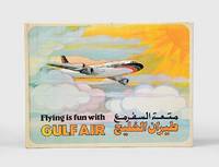
1974ref. 168084Bahrain: Gulf Public Relations 1974. First edition first printing of this pop-up book published by Gulf Air Public Relations in around 1970 with dual Arabic-English text by Ib Penick and illustrations by Gloria Nixon. The narrative revolves around Ahmed a boy who is flying from Manama to London with his parents. Quarto. 8 double-page full-colour illustrations by Gloria Nixon each one with a pop up all except the last with moving parts. Original coloured pictorial boards spine lettered in gold covers illustrated in colour and lettered in black and gold. Boards lightly toned spine lettering faded covers slightly soiled contents bright all moving parts in working order. A very good copy. hardcover
ref. UT36~4~2~22~STAZ~5Paperback. Good. Comes with original letter John McClure Snook with Baldwin Historical Society. Front and back cover intact both with speckle discoloration from improper storage. Spine is straight with vertical creases affecting top and bottom. Binding is secure and all pages intact. Pages have age tanning; no writing/marking of pages. paperback
ref. DADAX1945926163New unknown
ref. DADAX1138184195New unknown
ref. DADAX1138820326New unknown
ref. DADAX0415505658New unknown
ref. DADAX1138187267New unknown
ref. DADAX1138183342New unknown
ref. DADAX1138183121New unknown
ref. DADAX1138125091New unknown
ref. DADAX1138184004New unknown
ref. DADAX0807171727New unknown
ref. DADAX1138184039New unknown
ref. DADAX1138671029New unknown
ref. DADAX041565758XNew unknown
ref. DADAX1138184217New unknown
ref. DADAX0415650623New unknown
ref. DADAX1138874469New unknown
ref. DADAX1138183024New unknown
ref. DADAX1138476382New unknown
ref. DADAX1138187275New unknown
ref. SONG0231165129Used: Good unknown