4 034 résultats
réf. 2296011411.Gpaperback. Good. Access codes and supplements are not guaranteed with used items. May be an ex-library book. paperback
1997réf. Q-0028611608Frommer 1997-06-01. Paperback. New. In shrink wrap. Looks like an interesting title! Frommer paperback
réf. 384655894X.Gpaperback. Good. Access codes and supplements are not guaranteed with used items. May be an ex-library book. paperback
réf. 1020589949.Ghardcover. Good. Access codes and supplements are not guaranteed with used items. May be an ex-library book. hardcover
réf. 697855141Springer . Papeback. New. pp. 308 Springer unknown
réf. 63138332Springer . Hardback. Used. pp. x 297 Springer hardcover
réf. 0817636099.Ghardcover. Good. Access codes and supplements are not guaranteed with used items. May be an ex-library book. hardcover
1993réf. DBS-9780817636098Birk 1993. N/A. Hardcover. New. Birk hardcover
1993réf. AME_9780817636098Birk 1993. N/A. Hardcover. New/New. _ Birk hardcover
1993réf. 9940967Birkhäuser 1993. This is an ex-library book and may have the usual library/used-book markings inside.This book has hardback covers. Clean from markings. In good all round condition. No dust jacket. Please note the Image in this listing is a stock photo and may not match the covers of the actual item700grams ISBN:0817636099 Birkhäuser hardcover
réf. 9292692291.Gpaperback. Good. Access codes and supplements are not guaranteed with used items. May be an ex-library book. paperback
réf. 0522847919.Gpaperback. Good. Access codes and supplements are not guaranteed with used items. May be an ex-library book. paperback
réf. 97867Genève, Editions Henn, 1950. 15 x 24, 211 pp., reliure pleine rexine rouge, très bon état.
réf. 59850Genève, Editions Henn 1950, 250x170mm, 210pages, broché. Charnière supérieure fendue sur 3 cm en haut et en bas.
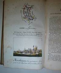
réf. 16-4577Paris : Palais-Royal Librairie d'Education de A. J. Sanson 1825. . This copy with the maps and town views all with contemporary handcoloring. OCLC Number: 642902888.Notes: Engravings by S. Hosse and Duchâtel.Title vignette.Publisher's advertisements: p. 2 and p. 179-180.Description: 180 pages 87 unnumbered leaves of plates : illustrations 87 maps with birds eye views all handcolored. ; 21 cm.In-8 12 x 20cm. cartonnage de l'époque plats illustrés. Ouvrage illustré d'une carte générale de France lithographiée avec contours colorié et de 86 planches lithographiées et coloriées. Les quatre-vingt-six départements ont chacun un feuillet de description accompagné d'une planche ornée d'une carte et d'une vue de la ville principale. Elles sont toutes lithographiées par Duchâtel d'après S. Hoffe. Parmi les villes représentées se trouvent La Rochelle Ajaccio Dijon Bordeaux Rennes Nantes Angers Vannes Lyon ou Paris. Bon exemplaire. Défauts aux coins et aux mors.Expertise by M. Christian GASCHBoite Postale 405F-58004 NEVERS Cedex. Paris : Palais-Royal, Librairie d'Education de A. J. Sanson, 1825. unknown
réf. 334703967X.Ghardcover. Good. Access codes and supplements are not guaranteed with used items. May be an ex-library book. hardcover
1678réf. M3434Paris: Mariette Pierre 1678. Excellent. Size : 390x522 mm 15.375x20.5 Inches Coloring: Original Outline with later cartouche coloring Category: ; Maps Asia Near East Turkey Mariette, Pierre unknown
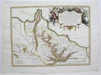
1713réf. 215454Amsterdam: Mortier Pieter 1713. unbound. very good. Map. Engraving with original hand outline. Image measures 14.5" x 18.75". Rare map of Paphlagonia an ancient region of northern Anatolia present-day Turkey along the southern coast of the Black Sea. Highlighting the capital city of Sinope this map depicts the region as defined by Strabo: bound by the Parthenius River in the west extending to the Hays river in the east. Sanson depicts the region comprising the Kingdom of Pontus during the rule of Mithridates IV. Neighboring historical regions of Gallatia and Bithynia et Pontus are labeled. Full original margins light scattered foxing. Based on earlier plates by Sanson. This map appeared in "Atlas Antiquus Sacer Ecclesiasticus et Profanus" published in Amsterdam by Pieter Mortier. Nicolas Sanson 1600-1667 who is considered the founder of the French school of cartography. In reaction to the prevailing trend of Dutch lavishness Sanson favored minimal details focusing rather on accurate cartography than ornament. Pierre Mortier 1661-1711 was a Dutch cartographer engraver and printseller who worked in Amsterdam. He used advanced Dutch printing methods to produce high quality editions of contemporary French maps by cartographers such as De L'Isle Sanson Jaillot de Fer and De Wit. His greatest feat was the nautical atlas "Le Neptune Francois" or "Suite de Neptune Francois" considered to contain the most beautiful examples of cartographic art. After his death his widow Amelia continued publishing in partnership with her brother-in-law David until her death in 1719. This map was published during Amelia's tenure at the firm. Mortier, Pieter unknown
1713réf. 215454Amsterdam: Mortier Pieter 1713. unbound. very good. Map. Engraving with original hand outline. Image measures 14.5" x 18.75". Rare map of Paphlagonia an ancient region of northern Anatolia present-day Turkey along the southern coast of the Black Sea. Highlighting the capital city of Sinope this map depicts the region as defined by Strabo: bound by the Parthenius River in the west extending to the Hays river in the east. Sanson depicts the region comprising the Kingdom of Pontus during the rule of Mithridates IV. Neighboring historical regions of Gallatia and Bithynia et Pontus are labeled. Full original margins light scattered foxing. Based on earlier plates by Sanson. This map appeared in "Atlas Antiquus Sacer Ecclesiasticus et Profanus" published in Amsterdam by Pieter Mortier. Nicolas Sanson 1600-1667 who is considered the founder of the French school of cartography. In reaction to the prevailing trend of Dutch lavishness Sanson favored minimal details focusing rather on accurate cartography than ornament. Pierre Mortier 1661-1711 was a Dutch cartographer engraver and printseller who worked in Amsterdam. He used advanced Dutch printing methods to produce high quality editions of contemporary French maps by cartographers such as De L'Isle Sanson Jaillot de Fer and De Wit. His greatest feat was the nautical atlas "Le Neptune Francois" or "Suite de Neptune Francois" considered to contain the most beautiful examples of cartographic art. After his death his widow Amelia continued publishing in partnership with her brother-in-law David until her death in 1719. This map was published during Amelia's tenure at the firm. Mortier, Pieter unknown books
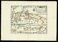
1652réf. 17601Paris: chez l'autheur 1652. 265 by 370mm. 10.5 by 14.5 inches. Maps""Les Isles Molucques; Celebes Gilolo &c. Sanson's Moluccas Engraved chart with contemporary hand-colour in outline. Detailed map of the island east of Borneo in Southeast Asia with an inset of Banda and the Moluccas. Published in Sanson's 'L'Asie en Plusieurs Cartes.' 1652. Nicolas Sanson 1600-1667 began to make maps to supplement his study of history and a map of Ancient Gaul made early in his career brought him to the attention of Cardinal Richelieu. This foothold in the French court allowed him to rise to the position of geographe du roi teaching both Louis XIII and Louis XIV. Louis XIII even made him a counsellor of state. Sanson produced an atlas 'Cartes Generales de Toutes les Parties du Monde' which contained important maps of the post roads and waterways of France. He also produced two major maps of North America: 'Amerique Septentrionale' 1650 was the first map to show the Great Lakes in a recognisable form aided by Sanson's access to The Jesuit Relations a collection of accounts by French missionaries to the area. The map was drawn on a sinusoidal projection which Sanson was the first to use. In 1656 he made 'Le Canada ou Nouvelle France' which showed the Great Lakes in greater detail and included accurate representations of the Hudson Bay area the Delaware and the Gulf of Saint Lawrence. chez l'autheur, unknown
18192 vols., 12mo., with fine engraved and printed titles, and a total of 8 engraved plates after Westall (most original tissue guards present), some minimal offsetting from plates; ORIGINAL BOARDS, very neatly rebacked to style, ORIGINAL PRINTED PAPER LABELS PRESERVED (labels chipped and worn but virtually all lettering entirely legible), uncut, boards mildly age-stained with a few old tape marks, else a most attractive and remarkably clean, crisp set in tastefully restored publisher's binding. The engraved titles, all after Westall and dated 1816, are by Engleheart (Vol. I: Paradise Regained) and Rhodes (Vol. II: Minor Poems). The fine engraved and captioned plates are also after Westall and dated 1816. In the first volume, the plates stand before Paradise Lost (Finden), Samson Agonistes (Romney) and Comus (Heath); in the second, the plates stand before Lycidas (Engleheart), L'Allegro (Heath), Il Penseroso (Mitan), Sonnets (Heath) and Odes (Finden).In the first volume Paradise Regained is paginated by line number only; the other works (including Arcades) are all separately paginated. In the second volume the pagination is continuous (including the Index).Something of a bibliographical puzzle here. The two volumes were clearly published as a set (vide the publisher's labels) but we can find no clear record of them as such. Volume I appears to be unrecorded by Stevens, falling as it does between Sharpe's first edition of 1809 and his quite distinct two-volume edition of 1827. Volume II would appear to be a later issue of Stevens 264 (who records the first edition thus as 1817 despite the dating on the engraved title). He makes the point that Vol. II was 'bound with his Paradise Regained, 1817' but lists no printings in 1819. These complexities notwithstanding, a scarce and delightful pair in well-nigh original period binding.
réf. 3250Americas: Amsterdam Francois Halma 1705. Copper engraved map of Paraguayby N. Sanson from Halma's Algemeene Werelde Beschryving Vol. 3 Black and white; title in Dutch; verso blank; strapwork title cartouche. The map shows the region of present day Paraguay Uruguay northern Argentina and southern Brazil. The Rio de la Plata is the main feature of the map along with the mountains and volcanoes of the Cordillera de los Andes. Engraved by Antoine de Winter. This map appeared in Algemeene Weereld-Beschryving nae de Rechte Verdeeling der Landschappen Plaetsen Zeeën Rivieren &c. Geographisch Politisch Historisch Chronologisch en Genealogisch a Dutch edition of A. Phérotée de la Croix's Nouvelle Methode Pour Apprendre Facilement la Geographie Universelle which first appeared in 1690. Dark impression; minor dampstain at top of centre fold. Nicolas Sanson d'Abbeville.1600-67 ' father of the French cartography' and founder of the Sanson firm. Atlas ' Cartes générales de toutes les parties du Monde' 1658-70 and a pocket atlas in 4 parts 1652-1705. Sanson's small maps from A. Phérotée de la Croix's Nouvelle Methode Pour Apprendre Facilement la Geographie Universelle. first published in 1652 and engraved by A. Peyrounin were copied several times by various map publishers. Johann David Zunners made copies of Sanson's maps for his German translation of Die Gantze Erd-Kugel in 1679. Johannes Ribbius and Simon de Vries published copies in 1682 and 1683 with new maps engraved by Antoine d'Winter. The plates were later sold to Francois Halma who used them in 1699 and then again in 1705 with the titles re-engraved in Dutch. François Halma 1653 - 1722 Dutch publisher/printer; dealer/auction house. Cartographer and publisher of maps active in Utrecht Amsterdam Franeker and Leeuwarden. Published 'Description de l'Univers' 1700; 'Algemene Wereldtbescrijving' 1705; 'Corpus Inscriptionum' 1707 and 'Lexicon Philosophicum' 1713. Keoman: Hal 1; Phillips 528. Americas South America Paraguay Uraguay Amsterdam Francois Halma 1705 unknown
1655réf. M5583Paris 1655. Very Good. Size : 385x535 mm 15.125x21 Inches Coloring: Hand Colored Category: Maps Africa North unknown
1948réf. 1660181948 PARIS . Aspects et reflets.Illustrations en couleurs de Ch Samson.Piazza , 1948 , grand in8 broché,193pp.Petits manques de papier au dos. Très bon état intérieur.