32 201 résultats
1987réf. 2080502106509643Aoshio-sha 1987. Soft Cover. Fine. Number of books: 4 Aoshio-sha paperback
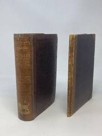
1853réf. 87405Washington DC: Robert Armstrong Public Printer 1853. Hardcover. Good. Quarto. 9 in. x 6 in. pp. 495. Maroon stamped cloth boards ruled in blind. Gilt lettering to spine as well as graphic in gilt of a buffalo. Bumped corners Stained endpapers with some penciled writing. Frontis lithograph. All plates as called for though several out of order. 58 lithographed illustrations. NOTE: Several plates are latter-day facsimiles to replace the few previously missing plates. Moderate foxing light spotting throughout and af few light pencil trials. Two Maps both originals accompanying Stansbury's report were originally issued as folded in a separate hardcover binding but for protection and close study the folding maps have been removed and safely stored in a clear archival display sleeve. Maps will be mailed under separate cover in a mail-tube. Maps are in generally good condition with some staining to folds archival tape professionally applied to several folds and a few short closed tears to edges; quarter size open tear to center of second map. The first map is entitled "Map of a Reconnaissance between Fort Leavenworth on the Missouri River and the Great Salt Lake in the Territory of Utah made in 1849 and 1850 under the orders of Col. J.J. Abert Chief of the Topographical Bureau by Capt. Howard Stansbury of the Corps of Topographical Engineers aided by Lieut. J.W. Gunnison Corpos Topographical Engineers and Albert Carrington. The adjacent country laid down from the latest and most authentic data. Drawn by Lieut. Gunnison and Charles Preuss." Wheat Mapping the Transmississippi West. The second accompanying map is titled "Map of the Great Salt Lake and Adjacent Country in the Territory of Utah Surveyed in 1849 and 1850.by Capt. Howard Stansbury of the Corps of Topographical Engineers and Albert Carrington. Drawn by Lieut. Gunnison and Charles Preuss." "Captain Howard Stansbury in 1849 had taken a topographical party west to make a thorough examination of the Great Salt Lake country and the routes from it.He was accompanied by Lieutenant John Williams Gunnison and they set out together from Fort Leavenworth on May 31 1849 traveling near the tail-end of the California emigration. Both officers kept journals of the march on which Stansbury also subsequently submitted an official report. Robert Armstrong, Public Printer hardcover
M., Antonio Marín, 1757, 21 x 15’5 cm., perg., escudo grabado – 13 h. – 406 págs.
1945réf. 4-946GPO 1945 1945. 1st ed. About 500p. Photos. Illustrations. Heavy. In original Printed binder. Lower corner missing from first page. Near Fine Copy. 1st. Hardcover. Near Fine. GPO, 1945 hardcover
1946réf. 62-207CHeidelberg 1946. 1946. Volumes I & II only. Many color foldout maps photos. Copy of Col. Earle G. Wheeler Then Chief of Staff of the 63d Infantry Division Later Chief of Staff of the US Army and Chairman of the Joint Chiefs of Staff during the Vietnam War. His name in gilt letters of the front of both volumes. Very heavy/Oversize. Quite worn esp. spines and edges. Fair set. 1st. Hardcover. Fair. Heidelberg, 1946. Hardcover
1900réf. 10413ABAkron, The Werner Com., 1900. Imp. Folio. 3 nn. Bll., 181 S. 41 Chromolithos. Deutscher u. engl. Text in 2 Spalten. Ldr. Verg. Deckeltit. u. farb. u. verg. Deckeldarst. Goldschn. Ecken u. Kapitale etw. bestossen, fl. Tls. m. kl. Einrissen, fl. Calf. Gilt title on boards, and coloured and gilt illustration on boards. Gilt edges. Sligthly rubbed and bumped, stained. Partly with little tears, stained. Nice copy.
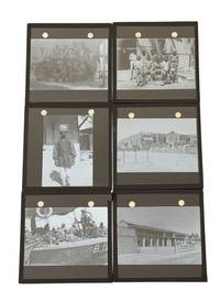
1916réf. 235501916. British Indian Army medical and transport lantern slide archive circa 1916 documenting the hospital personnel river craft and built environment of the Mesopotamia Campaign during World War I. The sign for "No. 10 Indian General Hospital" places the group within the British Indian Army medical network operating at Basra after the disastrous siege of Kut and the rapid expansion of medical facilities for Indian Expeditionary Force D. The slides record the imperial military system through hospitals military harbor craft Indian attendants British soldiers and institutional buildings. Photo archive of 8 glass lantern slides each 3.25 x 3.25 inches likely Basra Mesopotamia present day Iraq circa 1916. The slides show a group portrait of Western military men in shirtsleeves and campaign dress; a group of Indian men posed outside a palm shaded compound; an Indian man in turban coat and light trousers standing near a building; and a large institutional structure identified by a foreground sign reading "No. 10 Indian General Hospital." Other views show soldiers and crew aboard a river vessel marked "B.12"; a river steamer or launch moving along a waterway; a long bungalow or hospital ward with verandah fencing and palms; and a cemetery or memorial setting with military graves crosses and a decorated headstone. The images emphasize hospitals transport quarters and personnel with Indian and Western subjects appearing within the same military geography. No. 10 Indian General Hospital was part of the medical expansion that followed the early failures of the Mesopotamia Campaign when heat disease inadequate evacuation routes and insufficient hospital capacity exposed the weakness of British Indian medical planning. Basra became the principal receiving and hospital base for the campaign linking river transport from the front to permanent and temporary medical facilities near the Gulf. Light surface wear minor fading and occasional abrasions visible; glass show no signs of cracking or scratching mounts appear intact. Overall very good condition. A small record of British Indian Army medical logistics and colonial military presence in Mesopotamia during the First World War. unknown
1916réf. 235501916. British Indian Army medical and transport lantern slide archive circa 1916 documenting the hospital personnel river craft and built environment of the Mesopotamia Campaign during World War I. The sign for "No. 10 Indian General Hospital" places the group within the British Indian Army medical network operating at Basra after the disastrous siege of Kut and the rapid expansion of medical facilities for Indian Expeditionary Force D. The slides record the imperial military system through hospitals military harbor craft Indian attendants British soldiers and institutional buildings. Photo archive of 8 glass lantern slides each 3.25 x 3.25 inches likely Basra Mesopotamia present day Iraq circa 1916. The slides show a group portrait of Western military men in shirtsleeves and campaign dress; a group of Indian men posed outside a palm shaded compound; an Indian man in turban coat and light trousers standing near a building; and a large institutional structure identified by a foreground sign reading "No. 10 Indian General Hospital." Other views show soldiers and crew aboard a river vessel marked "B.12"; a river steamer or launch moving along a waterway; a long bungalow or hospital ward with verandah fencing and palms; and a cemetery or memorial setting with military graves crosses and a decorated headstone. The images emphasize hospitals transport quarters and personnel with Indian and Western subjects appearing within the same military geography. No. 10 Indian General Hospital was part of the medical expansion that followed the early failures of the Mesopotamia Campaign when heat disease inadequate evacuation routes and insufficient hospital capacity exposed the weakness of British Indian medical planning. Basra became the principal receiving and hospital base for the campaign linking river transport from the front to permanent and temporary medical facilities near the Gulf. Light surface wear minor fading and occasional abrasions visible; glass show no signs of cracking or scratching mounts appear intact. Overall very good condition. A small record of British Indian Army medical logistics and colonial military presence in Mesopotamia during the First World War. unknown books
1884réf. 01119474Grand Army Scout and Soldiers' Mail 1884. Weekly tabloid newspaper for Union veterans all 1884 issues Vol. III No. 4 Jan. 5 1884 through Vol. IV No. 3 Dec. 27 1884 bound in deep blue cloth-covered boards. Papers have their original folds and the occasional repaired edge tear but overall condition is very good. Hard Cover. Very Good/No Jacket. Folio. Grand Army Scout and Soldiers' Mail Hardcover
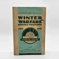
1945réf. 88616Ottawa: Department of National Defence 1945. First edition. Hardcover. Maps. 1945 Vol.I & II only of 3 8vo. Original pictorial cloth. Two volumes of rare military technical reports documenting Exercise Eskimo a significant joint winter warfare field trial conducted in northern Canada during the final stages of World War II. Involving approximately 1750 personnel from the Canadian Army and the Royal Canadian Air Force the exercise was designed to test the impact of sub-Arctic winter conditions on combat efficiency and military equipment across a wide range of operational areas — from clothing rations and the army postal service to tanks and heavy machinery. The volumes compile core observations technical data prototype equipment evaluations and formal recommendations for future winter operations and are illustrated with photographs throughout. One volume includes five large fold-out maps in rear pockets covering the Advance Withdrawal Lines of Communication Operations Air Operations and Winter Climatic Zones. Some minor occasional marking and creasing to contents; cloth slightly rubbed and marked. No jacket Department of National Defence hardcover
1890réf. 1108171890 A Paris, Librairie Haar & Steinert (C. Haar, Successeur) - 1890 - 2 volumes In-Folio, cartonnages verts, formats à l'italienne, illustrations contrecollées sur les premiers plats, étiquettes de titre manuscrites aux dos - 207 pages + environ 90 pages pour le second tome (suite des aquarelles sous serpente) - Illustrés de 620 gravures sur bois et accompagnée de 45 aquarelles en chromolithographie - Texte sur deux colonnes
1902réf. 18898Essai sur les troupes de la confédération du Rhin 1806-1813 par le capitaine, puis le commandant, puis le lieutenant colonel Sauzey de la Sabretache. Nombreuses gravures en noir et en couleurs.T1/ Le régiment de Francfort, avec une préface de Henry Houssaye. - 1902 - ix pp. + 118 pp. - 3 cartes dépliantes en fin de volume.T2/ Le contingent Badois, avec une préface de M.J. Margerand - 1904 - xii pp. + 172 pp. - 1 carte dépliante en fin de volume.T3/ Les Saxons dans nos rangs - 1907 - VI pp + 265 pp.T4/ Le régiment des Duchés de Saxe, avec une préface de M. Arthur Chuquet - 1908 - xvi pp. + 204 pp.T5/ Nos alliés les Bavarois, avec une préface de M. Arthur Chuquet - 1910 - x + 422 pp.T6/ Les soldats de Hesse et de Nassau, avec une préface du général Langlois - 1912 - xiv pp. + 317 pp. - 2 grandes cartes dépliantes en fin de volume.Edition originale. Paris, Librairie militaire R. Chapelot et cie - 1902-1912. Ex-libris René Lizard.Belle reliure demi-chagrin rouge de l'époque. Dos à nerfs orné avec un aigle surmonté d'une couronne. Dos avec titre, auteur, et tomaison dorés. Menus frottements aux dos. Pas de rousseur. Très bon état pour ce bel ensemble. Format in-8° (23x15).
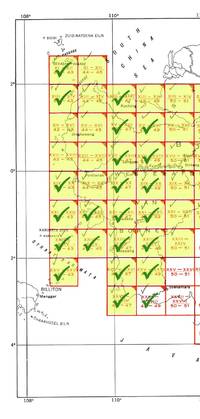
1944réf. 70378Washington DC: Army Map Service 1944. First edition 23 color broadside maps each about 22 x 20 in.; 1:200000 scale covering the western section of the series from XI-XII 42-43 to XXVII-XXVIII 48-49 lacking XI-XII 44-45 XIII-XIV 44-45 XIII-XIV 50-51 XV-XVI 42-43 XV-XVI 44-45 XVII-XVIII 42-43 XVII-XVIII 44-45 and XIV-XX 44-45. Geographical region covered is the west coast From Kuching to Soekamara and some outlying islands. Each map is numbered in marker on the bottom left margin otherwise clean and near fine. The Army Map Service was the primary map producing body of the US Military through WWII. Service cartographers many of them women recruited after Pearl Harbor produced 40000 maps covering 400000 miles between 1941 and 1945. LoC Their work formed the basis of silk escape maps provided to soldiers. Army Map Service unknown
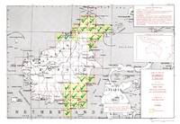
1945réf. 70379Washington DC: Army Map Service 1945. 23 broadside color maps; each about 22.25 x 20 in. 1:250.000 scale covering two separate regions: North Borneo including part of Brunei and Southeast Borneo from Samarinda to Kualakapuas and inland to Boentok. All maps in fine condition. Maps included are: NB-49 X; NB-50 I J O P Q R S V W; NA-50-D; SA-50-C D G H I M N O S T U; SB-50-A. The Army Map Service was the primary map producing body of the US Military through WWII. Service cartographers many of them women recruited after Pearl Harbor produced 40000 maps covering 400000 miles between 1941 and 1945. LoC Their work formed the basis of silk escape maps provided to soldiers. Army Map Service unknown
1944réf. 70378Washington DC: Army Map Service 1944. First edition 23 color broadside maps each about 22 x 20 in.; 1:200000 scale covering the western section of the series from XI-XII 42-43 to XXVII-XXVIII 48-49 lacking XI-XII 44-45 XIII-XIV 44-45 XIII-XIV 50-51 XV-XVI 42-43 XV-XVI 44-45 XVII-XVIII 42-43 XVII-XVIII 44-45 and XIV-XX 44-45. Geographical region covered is the west coast From Kuching to Soekamara and some outlying islands. Each map is numbered in marker on the bottom left margin otherwise clean and near fine. The Army Map Service was the primary map producing body of the US Military through WWII. Service cartographers many of them women recruited after Pearl Harbor produced 40000 maps covering 400000 miles between 1941 and 1945. LoC Their work formed the basis of silk escape maps provided to soldiers. Army Map Service unknown books
1945réf. 70379Washington DC: Army Map Service 1945. 23 broadside color maps; each about 22.25 x 20 in. 1:250.000 scale covering two separate regions: North Borneo including part of Brunei and Southeast Borneo from Samarinda to Kualakapuas and inland to Boentok. All maps in fine condition. Maps included are: NB-49 X; NB-50 I J O P Q R S V W; NA-50-D; SA-50-C D G H I M N O S T U; SB-50-A. The Army Map Service was the primary map producing body of the US Military through WWII. Service cartographers many of them women recruited after Pearl Harbor produced 40000 maps covering 400000 miles between 1941 and 1945. LoC Their work formed the basis of silk escape maps provided to soldiers. Army Map Service unknown books
1887réf. 60-330Philadelphia: Burk & McFetridge 1887. 1887. 43 leaves. Original Brown cloth. Very oversize. 19 x 24 inches. Ex. lib. Front cover bug damaged. Front hinge damaged. Hard Cover. Good. Philadelphia: Burk & McFetridge, 1887. Hardcover
2002réf. 2081502111905866Beijing Earthquake Publishing House 2002. Soft Cover. Fine. Number of pages: 1125p Size: B5 Hardcover Number of books: 4 Beijing Earthquake Publishing House paperback
1943réf. 438Details: color lithograph with manuscript pilot notations in pencil Folded double sided chart reverse World Pilotage Chart Location Index and Key condition: professionally conserved good condition original folds working aeronautical charts dimensions: various Description: List of Titles with dimensions: 1. Marrakech Morocco to Alger Algeria No. 64 dimensions: 14 10/16" x 57 ½" 2. Haut Plateau Algeria Africa No.421 dimensions: 21 7/8" x 28 ¾" 3. Alger Algeria to Tripoli Libya No. 65 dimensions: 14 ½" x 57 ½" 4. Tunis Tunisia to Bengasi Libya SFC 314 dimensions: 19 ¾" x 57 ½" 5. Bengasi Libya to Cairo Egypt FC 67 dimensions 21 7/8 x 28 3/4" 6. Karachi to New Delhi - Agra India 136 dimensions 14 1/2" x 58" 7. Thar Desert India 550 dimensions 22" x 29" 8. Jumna River India 552 dimensions 22 3/8" x 29 3/4" 9.Aravalli Range India 551 dimensions 22 3/8" x 29 9/16" 10. Tokara Group 491 Japan dimensions 22" x 28.75" U.S. Army Map Service
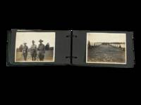
1916réf. 229001916. World War I mobilization photo album group of 65 photographs dating circa 1916-1918 documenting the training and daily life of U.S. soldiers during the pre-deployment period. The material captures the organization and routines of stateside military encampments as the United States prepared for overseas engagement providing visual evidence of training exercises camp infrastructure and soldier life. These images record both formal military activity and informal moments illustrating how enlisted men adapted to regimented environments while maintaining social bonds during the transition from civilian life to military service. Sixty-five black-and-white silver gelatin photographs each approximately 3 x 4 inches mounted in a ring-bound black leather album measuring about 3.5 x 6 inches. The images depict rows of conical canvas tents arranged in orderly lines soldiers standing in formation and groups engaged in drilling and instruction. Additional scenes show men performing camp labor including driving tent stakes transporting supplies cooking and resting on cots within tent interiors. Several photographs capture a regimental band assembled with visible instruments while others present candid moments of leisure and interaction. A pair of images shows two soldiers in improvised costume dress suggesting informal humor within camp life. The latter portion of the album shifts to civilian contexts with men in suits posed outdoors social gatherings in grassy settings and group portraits including women in light-colored dresses indicating family or community connections during leave periods. Produced during the United States' mobilization for World War I these photographs document the transformation of civilian individuals into military personnel within temporary training environments. The archive shows both the structured discipline of camp organization and the persistence of personal identity and social relationships. The inclusion of both military and civilian scenes provides a continuous narrative of service and home life supporting research into military training social history and vernacular photography of the World War I era. Scattered toning minor rubbing to album leaves and occasional corner lifting; binding secure with moderate cover wear; overall very good condition. A cohesive visual record of U.S. soldier experience during wartime mobilization. unknown
1916réf. 229001916. World War I mobilization photo album group of 65 photographs dating circa 1916-1918 documenting the training and daily life of U.S. soldiers during the pre-deployment period. The material captures the organization and routines of stateside military encampments as the United States prepared for overseas engagement providing visual evidence of training exercises camp infrastructure and soldier life. These images record both formal military activity and informal moments illustrating how enlisted men adapted to regimented environments while maintaining social bonds during the transition from civilian life to military service. Sixty-five black-and-white silver gelatin photographs each approximately 3 x 4 inches mounted in a ring-bound black leather album measuring about 3.5 x 6 inches. The images depict rows of conical canvas tents arranged in orderly lines soldiers standing in formation and groups engaged in drilling and instruction. Additional scenes show men performing camp labor including driving tent stakes transporting supplies cooking and resting on cots within tent interiors. Several photographs capture a regimental band assembled with visible instruments while others present candid moments of leisure and interaction. A pair of images shows two soldiers in improvised costume dress suggesting informal humor within camp life. The latter portion of the album shifts to civilian contexts with men in suits posed outdoors social gatherings in grassy settings and group portraits including women in light-colored dresses indicating family or community connections during leave periods. Produced during the United States' mobilization for World War I these photographs document the transformation of civilian individuals into military personnel within temporary training environments. The archive shows both the structured discipline of camp organization and the persistence of personal identity and social relationships. The inclusion of both military and civilian scenes provides a continuous narrative of service and home life supporting research into military training social history and vernacular photography of the World War I era. Scattered toning minor rubbing to album leaves and occasional corner lifting; binding secure with moderate cover wear; overall very good condition. A cohesive visual record of U.S. soldier experience during wartime mobilization. unknown books
1941réf. 86279Aberdeen Proving Ground MD: The Ordnance School 1941. Presumed First Edition First printing thus. Four-hole punched and held together with two two pronged clips. Good. Format is approximately 8 inches by 13 inches four-hole punched with two two pronged clips holding the text together. 3iii-vii 250 pages. Three pages of errata sheets. 18 appendices. 50 Figures. Printed single-sided only. Cover worn torn and soiled with some page wear and soiling noted. Pencil marks and notations on cover and some pages. The major portion of this text appears to be an early version of Field Manual No. 9-10 The Ordnance Company -Medium Maintenance; The Ordnance Battalion--Maintenance. It was apparently expected to be issued in July 1941 the the date of issue is blank. FM 9-10 Ordnance Field Manual Ordnance Field Maintenance was published on April 20 1942. There are substantial differences between this text and what was officially published as FM 9-10. This publication was intended solely for use as an Ordnance School text for instruction purposes only. It was not intended for general distribution to agencies or personnel outside the Ordnance training Center at Aberdeen Proving ground Md. It is reasonable to conclude that this instructional text was also a draft text for what would eventually become FM 9-10 and that the experience gained in its use at The Ordnance School contributed to the development of material changes. As such then this early version not labeled as a draft provides a significant and perhaps unique insight into the development of Ordnance doctrine training and practice at the Company and Battalion level at the time when the United States entered the Second World War. One page on Machine Gun Repairs to the M9197A1 laid in. The purpose of this manual was to present a coordinated and complete picture of the problem of ordnance field maintenance together with a logical solution of that problem. While this manual will be found to be helpful as a reference for operation of the maintenance organizations in garrison it was intended primarily as a guide for use in field operations. There are included in the various parts of this manual a discussion of a typical ordnance field shop and a method of conducting operations; a discussion of details pertaining to a typical maintenance company; and discussions of particular problems in ordnance field maintenance as they are encountered and solved. Except where obviously necessary in the interests of uniformity throughout all ordnance service it is not intended that this manual shall impose unnecessary restrictions on the imagination and initiative of ordnance personnel responsible for the operation of the units covered by this manual. On the contrary it is intended that the thoughts and imagination of such personnel will be stimulated to evolve more satisfactory solutions to the problems of ordnance field service. The organization of ordnance maintenance in the field army is based on the principle of progressive increases in available maintenance facilities from front to rear. The equipment and personnel assigned to each echelon are designed to carry the normal load of that echelon plus a certain peak load of the subordinate echelons. In Part I. The Ordnance Company - Medium Maintenance there are Chapters on General; Organization and Equipment; Operations; Duties of Individuals; and Administrative Details. Part II. The Ordnance Battalion Maintenance has Chapters on General and Operations. A list of appendices follow and are in turn followed by the list of Figures. There are specific discussions of ordnance weapons and vehicles and materiel. There is significant discussion of the inspection of ordnance materiel especially ammunition. The Ordnance School unknown
1943réf. 37635Camp Edwards MA: Engineer Amphibian Command 1943. fair. 221 wraps illus. diagrams bibliography covers worn scuffed and soiled ink marks on covers. Foreword by Brigadier General Daniel Noce Commanding. This is an extremely rare surviving piece of Army Amphibious Operations training development during WWII. Engineer Amphibian Command paperback
1819réf. 000014Paris Louis Janet, Janet et Cotelle 1819
1874réf. 3602333Berlin, Mittler, 1874/81. Mit zahlreichen Karten und Skizzen ausgestattetes monumentales Werk. Schwarze Original Ledereinbände. Deckel der Textbde. m. Wasserschaden. S. auch teilw. etwas wellig durch Feuchtigkeit.