1927ref. 3836863669GLN-7, Spes 1927
1927ref. 3836863897GLN-7, Spes 1927
1927ref. 3836863267GLN-7, Spes 1927
1927ref. 3836863308GLN-7, Spes 1927
1925ref. 3836865412GLN-7, Spes 1925
1925ref. 3836865407GLN-7, Spes 1925
1925ref. 3836865404GLN-7, Spes 1925
1925ref. 3836865402GLN-7, Spes 1925
1925ref. 3836865387GLN-7, Spes 1925
1925ref. 3836865362GLN-7, Spes 1925
1958ref. 5295582761Bibliothèque Ecclesia 45, GLN-181, Arthème Fayard 1958
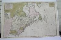
1698ref. M3704Paris 1698. Excellent. Notes: Rather rare original coloured version of this map an important 17th century map of the Great Lakes and East coast with an inset map of Boston. Cumming qtd in Arkway: "in spite of its scope and size it has a good deal of information for the Carolina Coast". This map by Sanson first appeared in Mortier's sea atlas "Le Neptune Francois"; interestingly it is not generally found in Sanson or Jaillot atlases. Size : 650x924 mm 25.625x36.375 Inches Coloring: Original Hand Coloring Reference: Arkway 58:23 Category: Maps Canada East; Maps United States New England unknown
ref. 21267P., Imprimerie Dubuisson, sans date pour les deux ouvrages, soit deux ouvrages reliés en un volume petit in 12, demi-percaline verte amateur, 188 et 192pp. ; qq. rousseurs ; reliure modeste.
1910ref. 5891910 1 Paris, Garnier, 1910, in-8 relié demi-percaline vieux rose.
1957ref. 79200MAUGARD 1957. Broché. Etat moyen. in-8. . MAUGARD unknown
1935ref. 1133011935 Librairie Plon, Paris - 1935 - Petit in-8, broché - XIII pages (préface) + 264 pages - Envoi de l'autrice (dédicace) en page de garde
1818Ritratto del personaggio distintosi nelle vittorie e conquiste militari francesi tra il 1792 e 1815. L'incisione, antica ed originale, è accompagnata da pagina con testo descrittivo del personaggio. Foxing
ref. 2091202133208116Not Available N.A. Soft Cover. Fine. Number of books: 1 Not Available paperback
1705ref. 3903Attractive original hand-color. Pin-head size stain just south of Mississippi delta please see image. An otherwise very nice clean copy. Paper size: 8 1/4 x 12 1/4 in 210 x 310 mm. Image size: 7 x 9.8 in 178 x 250 mm. ; All shipments through USPS insured Priority Mail.
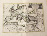
1710ref. M10325Amsterdam: Jean Covens & Corneille Mortier c.1710. Very Good. Size : 413x562 mm 16.26x22.13 Inches Coloring: Original Hand Coloring Category: Maps Europe Continent; Maps Africa North; Maps Mediterranean Sea; Jean Covens & Corneille Mortier unknown
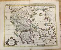
1710ref. M10235Amsterdam: Jean Covens & Corneille Mortier c.1710. Very Good. Size : 470x566 mm 18.50x22.28 Inches Coloring: Original Hand Coloring Category: Maps Europe Greece Macedonia; Jean Covens & Corneille Mortier unknown
ref. 0656632127.Ghardcover. Good. Access codes and supplements are not guaranteed with used items. May be an ex-library book. hardcover
ref. 0428884288.Ghardcover. Good. Access codes and supplements are not guaranteed with used items. May be an ex-library book. hardcover
ref. 0259030171.Gpaperback. Good. Access codes and supplements are not guaranteed with used items. May be an ex-library book. paperback
ref. 1333160763.Gpaperback. Good. Access codes and supplements are not guaranteed with used items. May be an ex-library book. paperback