Tardieu, AmbroiseBiblio.com

1 744 résultats
réf. 1011618036.Gpaperback. Good. Access codes and supplements are not guaranteed with used items. May be an ex-library book. paperback
réf. 29363Paris 1850 Gravure sur acier 42 x 51cm couleur epoque Bwx-09 unknown
réf. 29356Paris 1850 Gravure sur acier 42 x 51cm couleurs epoque Bwx-09 unknown
réf. 29346Paris 1850 Gravure sur acier 42 x 51cm couleurs epoque bx-1. Presentee en quatre cartes : Palestine ou Terre Sainte divisee en douze tribus puis deux royaumes et en quatre provinces et Syrie meridionale en 962 - Terre de Chanaan ou terre promise et voyages des israelites a sa recherche - Royaume d'Herode - Carte pour servir a l'intelligence des livres d'Esdras de Tobie de Judith d'Esther de Job et des prophetes sur laquelle on a trace l'itineraire des Apotres St Pierre et St Paul unknown
réf. 29360Paris 1850. Gravure sur acier 42 x 51cm couleur epoque Bwx-09 unknown
réf. 29354Paris 1850 Gravure sur acier 42 x 51cm couleur epoque Bwx-09 unknown
réf. 29361Paris 1850. Gravure sur acier 42 x 51cm couleur epoque Bwx-09 unknown
réf. 29355Paris 1850 Gravure sur acier 42 x 51cm couleur epoque Bwx-09 unknown
réf. 29357Paris 1850 Gravure sur acier 42 x 51cm couleur epoque Bwx-09 unknown
réf. 29343Paris 1850 Gravure sur acier 42 x 51cm couleurs epoque Bwx-09 unknown
réf. 29353Paris 1850 Gravure sur acier 42 x 51cm couleur epoque Bwx-09 unknown
réf. 29349Paris 1850 Gravure sur acier 42 x 51cm couleurs epoque Bwx-09 unknown
réf. 29345Paris 1850 Gravure sur acier 42 x 51cm couleurs epoque Bwx-09 unknown
réf. 29344Paris 1850 Gravure sur acier 42 x 51cm couleur epoque Bwx-09 unknown
réf. 29348Paris 1850 Gravure sur acier 42 x 51cm couleurs epoque Bwx-09 unknown
réf. 29351Paris 1850 Gravure sur acier 42 x 51cm couleurs epoque Bwx-09 unknown
réf. 29347Paris 1850 Gravure sur acier 42 x 51cm couleurs epoque Bwx-09 unknown
réf. 29359Paris 1850 Gravure sur acier 42 x 51cm couleur epoque Bwx-09 unknown
réf. 29362Paris 1850 Gravure sur acier 42 x 51cm couleur epoque Bwx-09 unknown
réf. 29350Paris 1850 Gravure sur acier 42 x 51cm couleurs epoque bw-14 unknown
réf. 5038Paris Gravure sur acier 42 x 51 cm couleurs epoque Bwx-09 unknown
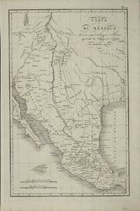
réf. 8820Paris: 1821. No binding. Very Good. 390 x 250 mm. early outline colour. A fine detailed map of present day Texas and the South West issued just prior to the founding of Stephen Austin's colony. It was published in the 'Atlas pour servir a L'Intelligence de l'Histoire Generale des Voyages de La Harpe' by Etienne Ledoux. The maps were provided by Amboise Tardieu 1788-1841 the son of another mapmaker Antoine Francois Tardieu. The design of the map is drawn from the 'Carte Generale du Royaume de la Nouvelle Espagne' of Alexander Humboldt issued in 1812. In the same year Stephen F. Austin's father Moses Austin obtained a grant from Spanish authorities in New Spain to settle nearly 300 families in an unsettled region of their territory which would later become known as Texas. The only recognisable settlement shown is San Antonio founded in 1718. The river network in the area is reasonably accurate for the time. The map extends northwards to 42 degrees and takes in Santa Fe and regions to its north. The areas western edge is shown as the source of the Colorado River but is all theoretical. The whole bears the names of a large number of Indian Tribes and place names. 1821 unknown
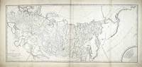
réf. 8105Paris: 1801. No binding. Good. 530 x 1025 mm. 2 maps joined as one some minor restoration and support to the edge in a couple of places generally in good condition. A superb detailed two-sheet map of Russia recording an important period in the history of Georgia. During the second half of the eighteenth century the country of Georgia turned towards Russia for protection from the Ottoman Empire to the south. Although keen to support Catherine the Great sent little in the way of forces. Threats also came from Persia who in 1795 entered the country and burnt the capital Tiblisi to the ground. Following the death of Erekle II in 1798 a struggle for the succession broke out and calls began for the Russians to intervene. On 8 January 1801 Tsar Paul I of Russia signed a decree incorporating Georgia into the Russian Empire. This was thrown a little into disarray as the Tsar lost support and was assassinated in March of 1801. The Treaty however was ratified by his successor Alexander I on 12 September 1801. This is important as there are two known states of the map. The first as here bears the name of Paul I only in the second line of 'Observations' lower left. The second state bears that of Alexander I also and the imprint below the title of Jean Claude Dezauche. The address given for his business is 40 Rue des Noyers to which Tooley ascribes the dates 1816-24. One further notable difference between the two is the presence here of a 'Remarque' with 9 lines of text across the lower right corner which are missing in the other state as is the quarter circle border around the scale of miles above. Without being able to examine the other state closely we have to assume that this offered here is the first state dating from early 1801. The map is engraved by Pierre François Tardieu 1752-1798 with the script being the work of L. Aubert who worked from about 1797. The map extends all the way east to the Pacific Ocean and beyond into the claimed territories in North America. The border of the Russian Empire extends out into the Ocean encompassing the Aleutian Islands. The Russian cartography is largely drawn from the earlier French work of De L'Isle with that of the Pacific being drawn from the work of Jean Francois de La Perouse. The Hawaiian Islands are placed in the extreme edge of the map. 1801 unknown
réf. ria9791041944897_inpPaperback. New. New Book; Fast Shipping from UK; Not signed; Not First Edition; Ambroise Tardieu explore en détail la pendaison la strangulation et la suffocation du point de vue médico-légal. Il met en évidence les distinctions essentielles entre ces causes de mort souvent confondues sous le terme d'asphyxie. L' paperback
réf. B9781020671098Hardback. New. hardcover