Container Atlas: A Practical Guide to Container Architecture
2010A clean, unmarked book with a tight binding. 256 pages. Many color photos. 9 1/2"w x 12"h.

Bookshop Pistil Books Online · Estados Unidos139,08 €
1751 resultados
1925Very Good Turkish, Ottoman (1500-1928) Original color map. Very good and clean. Atlas folio. (73 x 59 cm). In Ottoman script. Map of New United States, Canada, Alaska; and South America. Scale: 1/35000000. Hegira: 1341 = Gregorian: 1925. Mehmed Neset Bey was born in Scutari, Istanbul. He served as colonel in World War 1 and Turkish National Struggle. He was a military origin map-maker. (Source: Savaslarda haritacilar, Harita Genel Komutanligi, Ank., 2017). Extremely rare.
1894Very Good Turkish, Ottoman (1500-1928) Original color chromo-lithograph map. Folded. Oblong folio. (40 x 50 cm). In Ottoman script. Color lithograph. An attractive map which shows Austria-Hungary land with Venice Bay and North Italy. Scale: 1:3.500.000. Dated Hegira: 1310 = [Gregorian 1894]. This uncommon map of Austria-Hungary in Ottoman script was published in an atlas, 'Yeni cografya atlasi', which was issued in Istanbul in the late 19th century. Ali Seref Pasa or Hafiz Ali Esref. He was a soldier, who was schooled in Paris as a cartographer around 1862. Already in Paris, he published his first atlas with 22 maps, called 'Yeni atlas'. Upon his return to Istanbul, he became a chief cartographer at the Matbaa-i Amire Printing Press in Beyazit, which was the successor of the Muteferrika press from 1727. Among others, he translated the large Kiepert map of Anatolia to Ottoman. He died in 1907, leaving his large project of a gigantic map of Anatolia in 100 sheets unfinished. Ali's name is often misunderstood or even listed as two different people: Ali Seref Pasa and Hafiz Ali Esref. Until the surname law adopted on June 21, 1934, Turks did not have surnames. They were born with one first name and were until adulthood described only as sons or daughters of their parent's names. Later they were given titles such as Effendi (Sir), Bey (Chief), or Hanim (Madam) for higher classes, or they were given names according to their work or class. The names were not inherited by children until 1934 when the surname law was enforced. The mapmaker Ali received names Seref, the honorable, and Pasa, the dignitary. He was also known as Hafiz, the memorizer of the Qur'an and Esref, Proud. So Ali Seref Pasa would have a meaning 'Honourable Dignitary Ali, and Hafiz Ali Esref, Memorizer of Qur'an, Proud Ali. Daruttibaa - Matbaa-I Amire Printing Press: The first press in the Muslim world, called Daruttibaa, was founded in Istanbul by Ibrahim Muteferrika in 1727, with permission of Sultan Ahmet III. It was located in Muteferrika's house. The first book was published in 1729 and until 1742 sixteen other works followed. After Muteferrika's death, the press was suppressed for printing, as printed books were considered dangerous. In 1796 the press was purchased by the government and moved to Uskudar in Istanbul, and in 1831 finally to Beyazit, where it was renamed to Matbaa-i Amire in 1866. The press was closed in 1901 and was reopened in 1908 under the name 'Âmire' In 1927 the name changed to State Printing House. The press still exists and is known for publishing school and educational books. Extremely rare. Not in OCLC.; Not in TBMM Map Collection.
1894Very Good Turkish, Ottoman (1500-1928) Original color chromo-lithograph map. Folded. Oblong folio. (40 x 50 cm). In Ottoman script. Color lithograph. It Portugal and Spain with Gibraltar and North African shores. Scale: 1:3.500.000. Dated Hegira: 1310 = [Gregorian 1894]. OTTOMAN MAP of SPAIN & PORTUGAL] Ispanya & Portekiz: Sâye-i Türkiye Hazret Gazi Sultan Abdülhamid Hân-i Sâni'de Maarif Umûmiye Nezâret-i Celîlesi ruhsatiyle Haset tarafindan Fransa Cemiyet-i Cografya âzâlarindan mütesekkil komisyona mahsûs tanzîm edilmis oldugu son atlasinin tercümesi olarak bu def'a Erkân-i Umûmiyye Dairesi Besinci Fen Subesi'ne me'mûr piyade mirlivâlarindan saâdetlü Ali Seref Pasa maarifetleriyle tersîm ettirilmistir. This uncommon map of Spain and Portugal in Ottoman script was published in an atlas, 'Yeni cografya atlasi', which was issued in Istanbul in the late 19th century. Ali Seref Pasa or Hafix Ali Esref. He was a soldier, who was schooled in Paris as a cartographer around 1862. Already in Paris he published his first atlas with 22 maps, called 'Yeni atlas'. Upon his return to Istanbul he became a chief cartographer at the Maatbaa-i amire Printing Press in Beyazit, which was the successor of the Muteferrika press from 1727. Among others he translated the large Kiepert map of Anatolia to Ottoman. He died in 1907, leaving his large project of a gigantic map of Anatolia in 100 sheets unfinished. Ali's name is often misunderstood or even listed as two different people: Ali Seref Pasa and Hafiz Ali Esref. Until the surname law adopted on June 21, 1934, Turks did not have surnames. They were born with one first name and were until the adulthood described only as sons or daughters of their parent's names. Later they were given titles such as Effendi (Sir), Bey (Chief) or Hanim (Madam) for higher classes, or they were given names according to their work or class. The names were not inherited by children until 1934, when the surname law was enforced. The map maker Ali received names Seref, the honourable, and Pasa, the dignitary. He was also known as Hafiz, the memorizer of Qur'an and Esref, Proud. So Ali Seref Pasa would have a meaning 'Honourable Dignitary Ali, and Hafiz Ali Esref, Memorizer of Qur'an, Proud Ali. Daruttibaa - Matbaa-I Amire Printing Press: The first press in the Muslim world, called Daruttibaa, was founded in Istanbul by Ibrahim Muteferrika in 1727, with a permission of Sultan Ahmeet III. It was located in Muteferrika's house. The first book was published in 1729 and until 1742 sixteen other works followed. After Muteferrika's death, the press was supressed for printing, as printed books were considered dangerous. In 1796 the press was purchased by the government and moved to Uskudar in Istanbul, and in 1831 finally to Beyazit, where it was renamed to Matbaa-i Amire in 1866. The press was closed in 1901 and was reopened in 1908 under the name 'Âmire' In 1927 the name changed to State Printing House. The press still exists and is known for publishing school and educational books. Extremely rare. Not in OCLC.; Not in TBMM Map Collection.
1880Very Good French Original color map on cloth. Folded. Oblong atlas folio. (48 x 63 cm). Toponyms in German. It shows Sinop and Samsun city with their shores to 'Schwarzes Meer' and their hinterlands. [MAP] A IV. Sinob. Black Sea shores, Pontus Euxinus.
2010A clean, unmarked book with a tight binding. 256 pages. Many color photos. 9 1/2"w x 12"h.
1957Sm. 8vo., First Edition, with 4 maps (three double-page) as frontispiece, 158 plates on 96 and numerous illustrations in the text, some light offsetting from fold-ins to free endpapers; original tan cloth, gilt back, a near fine copy in price-clipped dustwrapper. 'Buildings of England', BE12. VERY SCARCE IN ANYTHING LIKE THIS CONDITION. Cherry 12 (HB1, HJ2)
1980ref. 2091502135305755Toshogu 1980. Soft Cover. Fine. Volume: 1 Toshogu paperback
ref. Ola SteenIn Pristine Condition. unknown
1916Very Good Turkish, Ottoman (1500-1928) Original color map. 50x60 cm. In Ottoman script. Scale: 1/200000. Ottoman map of Eastern Anatolia. Bargiri, Hoy, Baskal'a, Malazgird. It shows Lake Erçek located on the east of Lake Van which is an endorheic salt lake in Van Province in eastern Turkey, about 30 kilometres; on north side, Bargiri place where the oldest district of Van city; on east, Turkish and Azerbaijani and Iranian borders and Hoy city of the West Azerbaijan; and on west, map shows Malazgird [Malazgirt]. This is one the serie of the Bonn projection maps which are the first map series in modern techniques in Turkey and the Ottoman Empire. In order to produce these maps covering Turkish territory, Reconnaissance Branch was incorporated into The Mapping Commission. The maps were produced in the datum based on the latitude and longitude of Ayasofya Mosque in equal area Bonn Projection. The field works for the 123 sheets covering the country were conducted by 76 staff. The production was completed in 18 years starting from east west. Field works continued without stopping except in years 1914 and 1920. This map series called also reconnaissance maps contributed a lot to producing 1:25.000 scale maps.
1948Very Good Turkish Original color map. 52x65 cm. In Turkish. Scale: 1: 800,000. Showing shores from Latakia to Haifa; Lebanon , Beyrouth, North Palestine, Syria, Saudi Arabia and borders, Orontes river, deserts. [TURKISH MAP of BEYROUTH, DAMASCUS, JORDAN] Sam, Beyrouth, Lebanon, Jordan.
1987ref. 086783Singapore: Times Editions 1987. 160 pages chiefly colour illustrations; 42 cm. Firm binding clean inside copy. Fine DJ. OVERSIZE! Additional shipping charges may be requested for international & priority orders. A massive coffee-table book. Richly illustrated with colour plates. A lavish production. 2nd. Hardcover. Fine/Fine. Elephant Folio. Times Editions Hardcover
1888ref. 0005137Chicago: People's Publishing Co. 1888 circa. New edition. Pictorial Cloth. Good. Steel Engravings and woodcuts. 4to 649 pages recased original covers with new endpapers blue ink stain on bottom edge all edges gilt extremities worn. Uncommon. "Picturesque Ireland' is designed to embrace and present all the best and most striking features of preceding works on the subject .with hundreds of other views from recent photographs and drawings especially engraved for this work. . In this work every county in Ireland will be noticed and the remarkable features of each illustrated." Each county map is in colour. Steel Engravings and woodcuts. People's Publishing Co. hardcover
2003ref. 1-0471273805John Wiley & Sons Inc 2003. Hardcover. New. 2nd edition. 306 pages. 8.50x10.75x0.75 inches. John Wiley & Sons Inc hardcover
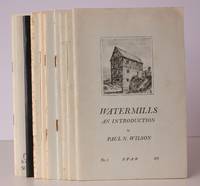
1970ref. 43460Society for the Protection of Ancient Buildings n.d. c.1970. 10 vols. 8vo. First Edition with numerous plates and illustrations pictorial wrappers wire-stitched as issued a very good bright clean set. Published by the Wind and Watermill Section Society for the Protection of Ancient Buildings. The set comprises: No. 1. Paul Wilson: Watermills. An Introduction; No. 2. Rex Wailes: Tide Mills. Part One; No. 3. Rex Wailes. Tide Mills. Part Two; No. 4. E.M. Gardner: Tide Mills. Part Three; No. 5. R.A. Pelham: Fulling Mills; No. 6. Kenneth C. Reid: Water-Mills and the Landscape; No. 7. Paul Wilson: Watermills with Horizontal Wheels; No. 8. David Luckhurst: Monastic Watermills; No. 9. Alfred Shorter: Water Paper Mills in England; No. 10. John Rollins: The Needle Mills. COMPLETE SETS ARE VERY SCARCE. Society for the Protection of Ancient Buildings, unknown
1895ref. 1511105Dresden, Meinhold, 1895-96. M. 43 (teils gef.) Taf. u. 353 Abb. 2 Bl., 524 S. Lwd. Etwas beschabt. St. a. Tit.
1924ref. 1038698Heide/Holst. Vlg Heider Anzeiger, 1924. Gr.-8vo. 6 Bl., 788, 39, (1) S. m. 1042 Textabb. OLwd.
1977ref. 0159061977 En feuilles
1967ref. 81200Paris, 1967, 43x31 oblong, reliure toilée éditeur, 52p. Très bon état. Nombreux plans, calques, croquis, photographies. Voir table des matières en photo.
ref. 27687PARIS, Bossange frères libraires, 1821/1822 - Reliure 1/2 basane romantique, frottée - Dos lisse orné - Tranches mouchetées - Signet - 2 tomes complets (sans l'atlas) -rousseurs éparses - In-8, 13 x 20,5 cm - LXXIII-443 et 511 pages-(3) - envoi rapide et soigné
1951pp. [9], 94-144. Features: Painters in Water Colour - A Silver Jubilee Exhibition; Academies by any other Name - Some Provoking Observations; Creative Craftsmanship in Jewellery; Georgian Bay Legacy; Aleksandre Bercovitch, 1893-1951; Jack Shadbolt Explores a World of Roots and Seeds; reflections on Canadian Ballet, 1950; architectural Competitions - Can They Help Us to Obtain Better Public Buildings?; The Water Colours of Fred Amess; and more. Writing on several pages. Pastedown illustration missing from front cover. Average wear. A sound reference copy of this informative issue. Book
192940 pages. Features: The Sears Roebuck office building in Minneapolis is featured in an ad for the Dovetail Anchor Slot Co. inside front cover; Super full-page photo ad for the Indiana Limestone company features the Palmolive Building in Chicago; Photo ad for Tidewater Red Cypress lumber; Nice pull-page photo ad for the Foley Saw Filer; Photo of the Ambassador Hotel Apartment Building in Milwaukee is featured in an ad for "Tie-To" inserts; Vintage full-page illustrated ad for International Trucks shows dump truck being loaded; vintage Skilsaw ad; The Missouri Pacific Building in St. Louis is featured in an ad for the Bonded Floors Company; Construction Technique in Remodeling - article with photos of how 5 stories were added to a 3-story building in San Francisco for a new department stor; Detailing Concrete Form Work - part V; Arc welding steel buildings and bridges - a review of progress to date and what remains to be done; The contractor and the courts; Latest prices of materials; Construction activity this week; Sealed proposal announcements; Back cover ad for General Electric features image of the Steuben Club Building in Chicago; and more. Average wear. Unmarked. A sound vintage copy. These nostalgic topics and images are certain to please modern-day contractors. Magazine
1998Features: Parodies of the Past - Vancouver is awash with fake heritage homes; New Buildings - Old Values - Vancouver's Recent Landmarks; Opportunity Lost - Vancouver's Canron Steel Plant falls to the wreckers; The economics of conserving built heritage; In Memoriam - Gabrielle Leger; Help for Heritage Tourism; Peterborough Armoury 'structurally unsafe' for Regiment; The Macdonell-Williamson House in Pointe-Fortune, on the Ontario-Quebec border; Heritage buildings on the block in Saint John, NB - Centracare Complex and Centenary Queen Square United Church; Brampton's sense of its own history questioned. (Please note: front cover incorrectly states this is the Spring 1998 issue) Clean, bright and unmarked with negligible wear. An excellent copy. Book
1996ref. 2091202133212720Rengeji 1996. Soft Cover. Fine. Volume: 1 Rengeji paperback
1978ref. 2091502135308236Repair Committee 1978. Soft Cover. Fine. Volume: 1 Repair Committee paperback
1997ref. 2091502135420382Yamanashi Prefecture Jigenji Temple 1997. Soft Cover. Fine. Number of books: 1 (Yamanashi Prefecture) Jigenji Temple paperback