138 resultados
1900np. Photographs with locations. Oblong 12mo. 5 1/2" x 8 3/4". Original pictorial wraps bound in tablet form. Crisp Copy. PA PAMPH 20_7 BX3 x 3c Crisp
1898ref. 621374The Builder London 1898. Unframed Print. Very Good Condition. A double sheet print image area approx. 28 x 38 cms. The illustrations found in leading architectural journals of the nineteenth and early twentieth centuries such as The Builder Building News and The Architect are masterpieces of visual craftsmanship. These illustrations capture the elegance intricacy and stylistic flair of the period's architecture. Rich in ornamental detail and atmospheric depth they reflect not only the buildings themselves but the artistic sensibilities and design discourse of their age. THIS IS AN ORIGINAL PAGE FROM THE JOURNAL PRINTED AT THE DATE SHOWN IN THE TITLE NOT A REPRINT OR COPY. Category: Builder & Building News; PRINTS : Buildings & Places; New Arrivals; Unframed Prints : Old. This item may require more postage than the rates shown for delivery outside the UK. If extra postage is required we will contact you before processing your order and you will be given the details and option to decline the extra cost. The Builder unknown
1848ref. 6655Paris, L. Mathias, 1848 ; in-8, broché ; X, (2), 299 pp., 2 tableaux dépliants hors-texte, 4 grandes planches hors-texte gravées par Dulos.
1838ref. 12376Lyon, Imprimerie de Pélagaud, Lesne et Crozet, 1838 ; in-8, cartonnage rigide de papier marbré, pièce de titre bordeaux en long (reliure moderne) ; 24 pp.
1835ref. 0009264London: John Weale Architectural Library 1835 / 1836. First edition. Good. 8vo 476 pages plates marginal tear in leaf 169/170; full polished calf extra-gilt spine extremities worn. Note: attempted collation but very complicated despite lengthy mixed-up descriptons in the text and duplicate numberes on different plates. The title-page is dated 1835; the engraved frontispiece is dated 1836; AND another third title-page is 1836 - but with a variant title !! Embracing Account and Illustrations of St. Stephen's Chapel and its Cloisters . Westminster Hall . The Court of Requests . The Painted Chamber &c &c. This work was inspired by the burning of the Houses of Parliament in 1834. It is illustrated with 48 engravings - 8 more and 100 pages more than promised to their subscribers. John Weale, Architectural Library unknown
1895Ex reference library book with usual (minimal) marks and stamps. Slight finger marking to a few pages, small piece missing from upper corner of half-title page and rubbing to spine ends. No creasing to covers or to spine. All edges gilt. Covers and spine embossed with gilt and green. Rubbing/scratching to rear board. 405-556pp.
1857ref. 160570Stuttgart, C. Mäcken, 1857. Fol. 25 doppelblattgr. Taf. in Strichlithographie auf Stegen. OBr. Umschl. angeschmutzt u. angerissen. sowie m. Sign. St. u. Sign. a. Tit.
189416 pages. 13" x 10.5" oblong. Wonderful full-page black and white photos of: Seven Dials, London; Eaton Hall, near Chester, England; Royal Library in Berlin; The Interior of St. Mark's Church, Venice; Panorama of Naples, Italy; St. Gothard Tunnel, Switzerland; Lady Kazan Cathedral, St. Petersburg; Private Mosque of the Turkish Sultan, Constantinople; Queen Street, Auckland, New Zealand; Yale College; The Parliament Buildings, Ottawa, Canada; Railroad Station, Santiago, Chili (Chile); Church and Convent of San Francisco, Lima, Peru; The Holy Family, by Murillo; The Lion of Lucerne; Street Scene in Melbourne. Moderate wear. Unmarked. A sound copy. Book
189416 pages. 13" x 10.5" oblong. Wonderful full-page black and white photos of: Poet's Corner, Westminster Abby; The Municipal Buildings, Aberdeen; City of Munich, Germany; Lake Maggiore, Italy; The Hotel De Ville, or, City Hall, Paris; Trollhattan Falls, Sweden; Water Carriers in Cairo; The City of Damascus; Tea Plantation in China; City of Calcutta, India; The State, War and Navy Departments, Washington, D.C.; City Hall Square, New York; The City of Zacatecas, Mexico; Hyde Park, London - a busy street scene; Royal Museum, Berlin; The Ghiberti bronze doors in Florence. Moderate wear. Tears/chips to fore-edge of first three pages. Unmarked. A sound copy. Book
1880ref. 59333No. place, no date, ca. 1880. Imperial folio. (72 x 49,5 cm.). Contemp. full cloth. Titlelabel with gilt lettering on upper cover. Containing 9 double-folio plates printed in blue, each measuring 70 x 94 cm.
1880ref. 59333No. place no date ca. 1880. Imperial folio. 72 x 495 cm. Contemp. full cloth. Titlelabel with gilt lettering on upper cover. Containing 9 double-folio plates printed in blue each measuring 70 x 94 cm. hardcover
1889This fascinating color illustration groups 78 of the old world's tallest structures ranging from the Porcelain Tower in Nankin, China to the second pyramid at Gheezeh. The highest structure included is the Washington Monument at 555 feet. Red tint indicates brick, pink indicates granite, purple indicates bronze, etc. Outer dimensions: 10.75" x 14.5". Light wear and soiling. Small chips from lower left corner. Provides a vivid contrast to today's much taller structures. Book
1880ref. 0267-05[ca. 1880]. [Album of views in Egypt]. 40 lose Orig.-Albumen-Photographien auf Kartons kasch. 21,5 x 27,5 cm. (Plattengr.). Ln.-Flügelmappe d. Zt. m. Deckelgoldprägung.
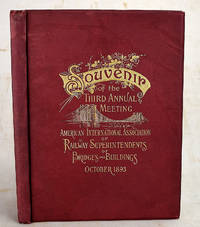
1893ref. 1908200047Philadelphia : Burke & McFetridge Co 1893. First Edition. Hardcover. Very Good. Bound in publisher's red cloth with gilt lettering and bridge on front. Hardcover. Good binding and cover. Clean unmarked pages. 108 pages : illustrations ; 26 cm. All edges gilt. Numerous illustrations photographs and ads related to Philadelphia and railroads. Text includes a history of the Association; an interesting essay on the "origin and progress of architecture and building" by George W. Andrews; and an essay on "Associations as an educational factor." Illustrates a number of Philadelphia buildings and gives their architects. Philadelphia : Burke & McFetridge Co hardcover
1875Paris, Dunod éditeur 1875. In-16 relié pleine toile de l'éditeur, titre doré sur le plat, fermeture. Petite déchirure sans manque au dos. 66 pages + agenda. Planche dépliante. Annotations sur l'agenda.
1897Very Good Turkish, Ottoman (1500-1928) Original engraved map on the silk handkerchief made in Yildiz Palace for the 'Iane Sergisi' [i.e. Exhibition of the Social Assistance] in the period of Sultan Abdülhamid II. In its decorative frame. Frame size: 53,5x53,5 cm; map size: 38x38 cm. In Ottoman script. Scale: 1/600.000. Several minimal splits, minor foxing, and slight stains on cloth. Otherwise in good condition. A rare and decorative 1897 silk handkerchief map of the Greco-Turkish War in 1897, which was the only war in which the Ottoman army was victorious during the reign of Abdulhamid 2, is a fine example of Ottoman / Turkish cartographic textiles made in Ottoman court (Yildiz Palace textile workshops). This beautiful map depicts an attractive war scene from the 1313 Greek War on the upper half, and it's engraved a map of Balkan & Greek lands on its lower half. War painting has 'Melona' signature in Ottoman script. The map shows Thessaloniki [i.e. Salonica] Bay on the west; Yanya [i.e. Ioanna] Vilayat on the east; lands of Greece, Galos Bay, Uzi Strait on the south and Dimetoka and Avalonia areas in the Serefiye, Ergiri sanjaks on the north in its period. Written on the map, "Baht-i himâye-yi feyzvâne-i cenâb-i hilâfetpenâhide evlad-i süheda ve mecrûhin-i asakir-i sâhâne", [i.e. It was printed for the "Iane Sergisi" (i.e. The Social Help Exhibition) in the high memory of our soldiers who were martyred and veterans in the Greek War under the patronage of the Sultan.]. The Greco-Turkish War of 1897, also called the Thirty Days' War and known in Greece as the Black '97 (Mauro '97), or the Unfortunate War (Atychis polemos), was a war fought between the Kingdom of Greece and the Ottoman Empire. Its immediate cause was the question over the status of the Ottoman province of Crete, whose Greek majority long-desired union with Greece. Despite the Ottoman victory on the field, an autonomous Cretan State under Ottoman suzerainty was established the following year (as a result of the intervention of the Great Powers after the war), with Prince George of Greece and Denmark as its first High Commissioner. This was the first war effort in which the military and political personnel of Greece were put to test since the Greek War of Independence in 1821. For the Ottoman Empire, this was also the first war effort in which the reorganized military personnel were put to test. The Ottoman army was under the guidance of a German military mission led by Colmar Freiherr von der Goltz, who had reorganized it after the defeat in the Russo-Turkish War (1877-1878). The conflict proved Greece was wholly unprepared for war. Plans, fortifications and weapons were non-existent, the mass of the officer corps was unsuited to its tasks, and training was inadequate. As a result, the numerically superior, better organized, equipped and led Ottoman forces pushed the Greek forces south out of Thessaly. Almost all of the aids made to the families or disabled people of those who were martyred in the 1897 Ottoman-Greek War (such as printing this map) were made within the framework of the donations of "Evlâd-i Süheda and Malûlîn-i Guzât-i Asâkir-i Sahane". People and citizens of all classes and beliefs, including members of the Ottoman court, ministers, bureaucrats, civil servants, merchants and tradesmen, participated in this aid campaign at the end of the 19th, beginning of the 20th century. Not in OCLC.
1890Very Good Turkish, Ottoman (1500-1928) Original color map. Folded. Very good. Large oblong 8vo. (21 x 26 cm). In Ottoman script. [MAP of OTTOMANT SALONICA -THESSALONIKI-] Selânik Vilâyeti. Ottoman Greece. Scale: 1/1.500.000. It shows Thessaloniki and its around. Manastir Vilayat, At north Kosovo, Siroz Sandjak etc.
1890Very Good Turkish, Ottoman (1500-1928) Original color map. Folded. Very good. Obblong 4to. (21 x 38 cm). In Ottoman script. Scale:: 1/500.000. [MAP of OTTOMAN PROVINCE of TREBIZOND] Trabzon Vilâyeti, Trabzon Sancagi, Canik Sancagi, Sivas Vilâyeti. [Provinces of Trabzon and Sivas; Canik and Trebizond Sandjak]. Black Sea at north.
1890Very Good Turkish, Ottoman (1500-1928) Original color map. Folded. Very good. Large oblong 8vo. (26 x 26 cm). In Ottoman script. [MAP of OTTOMAN PROVINCE of SIVAS] Sivas Vilâyeti, Trabzon Vilâyeti, Tokat Sancagi. [Sivas and Trabzon Provinces, Tokat Sandjak]. Scale: 1/1.500.000.
1890Very Good Turkish, Ottoman (1500-1928) Original color map. Folded. Very good. Oblong 4to. (21 x 42 cm). In Ottoman script. [MAP of OTTOMAN PROVINCE of KONIA] Konya Vlâyeti and around; Burdur, Isparta, Teke sandjaks, Hüdavendigâr Province Tozlu Ova, Tuz Gölü etc. Scale: 1/500.000.
1890Very Good Turkish, Ottoman (1500-1928) Original color map. Folded. Very good. Large oblong 4to. (19 x 37 cm). In Ottoman script. [MAP of OTTOMAN PROVINCE of ERZURUM] Erzurum Vilâyeti. Province of Erzurum of east Anatolia and its around. Many sandjaks and provinces with their detailed place names. Scale: 1/1.500.000.
1890Very Good Turkish, Ottoman (1500-1928) Original color map. Folded. Very good. Large oblong 8vo. (21 x 26 cm). In Ottoman script. [MAP of OTTOMAN PROVINCE of EASTERN ROUMELI] Rumeli-yi Sarkî Vilâyeti, Bulgaristan Eyâleti, Edirne Vilâyeti, [Trakya], Selânik Vilâyeti. [East Roumeli, Salonica, Adrianople provinces; Old Zagra Sandjak, Bulgarian State]. Scale: 1/1.500.000. Ottoman Provinces in the Balkan Peninsula.
1890Very Good Turkish, Ottoman (1500-1928) Original color map. Folded. Very good. Large oblong 8vo. (21 x 26 cm). In Ottoman script. [MAP of OTTOMAN PROVINCE of DIYAR-I BEKR] Diyarbakir Vilâyeti. Province of Diyarbekir in Southeast Anatolia and its around. Many sandjaks and provinces with their detailed place names. Scale: 1/500.000.
1890Very Good Turkish, Ottoman (1500-1928) Original color map. Folded. Very good. Large oblong 8vo. (21 x 26 cm). In Ottoman script. [MAP of OTTOMAN PROVINCE of DIYAR-I BEKR] Diyarbakir Vilâyeti. Province of Diyarbekir in Southeast Anatolia and its around. Many sandjaks and provinces with their detailed place names. Scale: 1/1.500.000.