Usher, DEA (Ted) (Signed) D E ABiblio.com

10 210 résultats
2000réf. 646c8602Coquitlam BC Canada: Self-Published. Fine in Fine dust jacket. 2000. First Edition. Hardcover. 1550567853 . 136 pages. ".First and foremost a pictorial history of the police force supplemented with descriptions anecdotes and a short history of New Westminster. Included is a reference section for many of the badges pocket rank and hat used by the force over the years. There is also a shoulder patch collection assembled by Staff Sergeant Larry Smith. Outlines the growth of the force from a one man department in 1873 to a modern community-based Police Service with a staff of over 150 plus hundreds of volunteers." - from dust jacket. Large handsome gilt decoration upon navy front board. Nicely signed and dated by author upon verso of front free endpaper. Book like new aside from a faint spot of soiling atop front free endpaper with corresponding mark inside front board. Dust jacket bears negligible wear and is now preserved in a glossy new archival-grade Brodart cover. A beautiful copy; 4to - over 9¾" - 12" tall; Policing the Royal City: A History of the New Westminster Police Service British Columbia; Signed by Authors . Self-Published hardcover
2013réf. Gyan-9789332858466Isha Books 2013. Hardcover. New. 28.94 x 22.59 x 13.14 cm. English Isha Books hardcover
2013réf. Gyan-9789332858466Isha Books 2013. Hardcover. New. 28.94 x 22.59 x 13.14 cm. English Isha Books hardcover
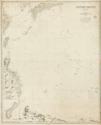
1884réf. 143681London: James Imray and Son 1884. Very Good. London James Imray and Son 1884. A very large engraved chart printed on two sheets combined printed surface 1268 × 1015 mm overall total size 1280 × 1048 mm mounted on the original blue backing paper with the publisher's title-label on the verso. Chips and short tears to the margins in a few places clear of the printed surface; a few small light stains and other minor signs of age and handling; in very good condition with faint pencil annotations tracking a voyage to Hangzhou in September 1888. A very large and detailed blueback chart of the western rim of the Pacific Ocean including the East China Sea Philippine Sea and parts of the coastlines of Japan Korea China Taiwan the Philippines and New Guinea. It features eight inset charts: Guajan Island; Borodino Island; Umata Bay; Farralon de Medinilla; Rota; Alamagan; Guguan; and Rosario Island. Both sheets incorporate corrections to June 1884. The title-label on the verso reads 'Chart No 193. Western Pacific in Seven Charts. Chart No. 4. Price 8s.'. James Imray and Son unknown
réf. DADAX0393922138New unknown
2007New English Paperback. Pbo. Mint. Demy 8vo. (21 x 14 cm). Turkish Edition of EsseGesse's Capitan Miki. Every issue is 226 p. B/w ills. Tommiks 1-34. 34 volumes set. Hoz Comics Full Set. [=Capitan Miki]. Covers by Fatih Okta.
réf. DADAX0198227531New unknown
1897réf. ZB327926Chicago: G. P. Engelhard & Co. 1897-1898. Price HAS BEEN REDUCED by 10% until Monday Oct. 26 weekend SALE item Volumes 19 and 20 only; quarto 592 pp. 589 pp both in one later half leather binding now worn and lacking spine covering text age toned but not fragile good only. - If you are reading this this item is actually physically in our stock and ready for shipment once ordered. We are not bookjackers. Buyer is responsible for any additional duties taxes or fees required by recipient's country. Photos available upon request. Chicago: G. P. Engelhard & Co., hardcover
19982 vols., 4to., First Edition thus, with titles in green, orange and black, many hundreds of coloured and monochrome illustrations and maps, and coloured endpaper maps; black cloth, gilt backs, a near fine set in unclipped dustwrapper, the whole housed publisher's illustrated board slip-case. Based on the nine-volume Handbook of the Birds of Europe, the Middle East, and North Africa. The set comprises: Vol. I: Non-Passerines; Vol. II: Passerines. Nice copy of a standard reference.
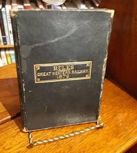
1879réf. 014135London Ontario: Advertiser Steam Presses / Great Western Railway 1879. 1st Edition . Hardcover. Very Good. First edition thus. 1879. Duodecimo 12mo. 102 pp. Very good. Black leather with flap enclosure binding. Gold titling to front board: "RULES. Great Western Railway. 1879." Ownership signature to FFEP: "Jos Anderson Conductor GWR Windsor July 29th 1879." A scarce rules and regulations book for the now defunct Great Western Railway in Ontario Canada. Marbled block. Clean throughout. The front hinge is lightly shaken though the binding is tight and fully intact. Black leather has a minor water stain to the front board. General wear and rubbing to the corners and extremities from use in the field. A scarce piece of rail and transportation history. A print copy is held in the Library and Archives of Canada. Securely shipped in a tracked box. Advertiser Steam Presses / Great Western Railway hardcover
réf. 63525, Brepols, 2023 Hardback, 2 vols, 1003 pages, Size:216 x 280 mm, Illustrations:722 b/w, 95 col., 1 tables b/w., 2 maps b/w, 9 maps color, Language: English. ISBN 9782503604664.
2026réf. x-1032658894Taylor & Francis Ltd 2026. Hardcover. New. 166 pages. 9.18x6.12x9.45 inches. Taylor & Francis Ltd hardcover
1997réf. x-075070683XFalmer Pr 1997. Hardcover. New. revised edition. 240 pages. 9.75x6.50x0.75 inches. Falmer Pr hardcover
2026réf. x-0367484560Taylor & Francis Ltd 2026. Hardcover. New. 252 pages. 9.18x6.12x9.45 inches. Taylor & Francis Ltd hardcover
2004réf. x-0415369681Routledge 2004. Hardcover. New. 1st edition. 216 pages. 9.25x6.25x0.50 inches. Routledge hardcover
2016réf. x-1138154008Taylor & Francis 2016. Hardcover. New. 256 pages. 9.21x6.14x9.25 inches. Taylor & Francis hardcover
1872296 p. Hardcover Very good t.p. cracked at inner hinge
2012réf. x-140944371XAshgate Pub Co 2012. Hardcover. New. 280 pages. 9.45x6.18x0.94 inches. Ashgate Pub Co hardcover
2020New English Original decorative cloth bdg. Folio. (33 x 33 cm). In English and Turkish.155 p., color and b/w ills., maps (some folded). Some of plans - maps and their makers from the contents of book: "The earliest city planning sketches displaying the then status of the city are the plans drawn by Livio Amedeo Missir located at the Santa Maria Church.", The well-known geographer Jean Denis barbie de Bocage's plan, In 1830s, British Navy Officer's plans, Luigi Storari's plan, Lamec Saad's plan, Charles Goad's plans, Karl Baedeker's plans, and very important maps of Izmir (Smyrna - Smyrne) city. 500 copies were printed.
1662Carta geografica tratta dall'edizione latina del "Atlas Major". Incisione in rame, coloritura coeva, in ottimo stato id conservazione. This is a decorative map of the western part of Africa extending from present-day Senegal to Angola. The interior is filled with information, mostly spurious, including the Nile originating in Zaire Lacus. A small herd of elephants roams the interior, along with ships sailing the sea. Dutch text on verso. The map has a decorative cartouche surrounded in a large elephant, lion, monkey, and a trio of natives holding an ivory tusk.A scale of miles on the lower left corner is lavished with monkeys, a cheetah, and mer-people.
2023réf. x-1032638346Routledge 2023. Hardcover. New. 505 pages. 9.19x6.13x1.34 inches. Routledge hardcover
réf. DADAX0415330548New unknown
réf. DADAX0415170591New unknown
réf. DADAX0792320751New unknown
réf. DADAX0415687594New unknown