22 556 résultats
1992réf. 026571Bellingham WA U.S.A.: SPIE PRESS-The International Society for Optical Engineering 1992. Ex-Library. Very Good. Paperback. 1st. Seller's image know what you are getting! Pre-packing weight is 2 lb. 4.4 oz . ORIGINAL NOT A REPRINT OR PHOTOCOPY!! NO Dust Jacket. Has or May Have all standard Library markings pocket labels stamps wear and soil to covers. CLEAN TEXT! See Picture! The Copyright date is 1992 for this Printing. This volume was purchased through DMRO from the Wright-Patterson Technical Library in the late 1990's. EXTRA MEDIA MAIL SHIPPING WOULD BE REQUIRED BUT WILL NOT BE COLLECTED AS $2.00 OF PRICE IS FOR EXTRA POSTAGE! So it will ship at the One Book rate. Please consider this when comparing pricing! Thank you for your purchase from Sunset Books! Help Promote World Literacy GIVE a Book as a GIFT!! In stock Ships from Ohio. WE COMBINE SHIPPING ON MULTIPLE PURCHASES!!!! SEE PICTURES!!!!! ANY ODD/GREEN TONES ON THE SCANS ARE CAUSED BY MY SCANNER!! All of our Technical/Textbook/Ex-Library volumes were obtained legally through Public or Auction sales. Size: 4to. SPIE PRESS-The International Society for Optical Engineering Paperback
2016réf. 2-0123959624Academic Press 2016. Paperback. New. 338 pages. 9.25x6.00x0.77 inches. Academic Press paperback
1993réf. G0124019404I4N00Academic Press 1993. Hardcover. Very Good. May have limited writing in cover pages. Pages are unmarked. ~ ThriftBooks: Read More Spend Less.Dust jacket quality is not guaranteed. Academic Press hardcover

réf. 10522373-20Elsevier Science & Technology. Used - Good. Former library copy. Pages intact with minimal writing/highlighting. The binding may be loose and creased. Dust jackets/supplements are not included. Includes library markings. Stock photo provided. Product includes identifying sticker. Better World Books: Buy Books. Do Good. Elsevier Science & Technology unknown
1984réf. SBBIH-4T7RBIUWIAHCRoutledge 1984. hardcover. Good. Our good condition books are generally good for reading but not for gifting or collecting. They could have imperfections such as creasing fanning inscriptions margin notes yellowing staining on edge or cover or pages bumps scuffs etc etc sometimes multiple of these. It's a wide category that encompasses anything that isn't almost-new down to anything that is slightly better than poor. We would NOT recommend gifting Good books - these should be considered reading copies. Our books are dispatched from a Yorkshire former cotton mill. We list via barcode/ISBN so please note that the images are stock images and may not be the exact copy you receive furthermore the details about edition and year might not be accurate as many publishers reuse the same ISBN for multiple editions and as we simply scan a barcode or enter an ISBN we do not check the validity of the edition data when listing. If you're looking for an exact edition please don't order at least not without checking with us first although we don't always have time to check. We aim to dispatch prompty the service used will depend on order value and book size. We can ship to most countries see our shipping policies. Payment is via Abe only. Routledge hardcover
réf. 0656702087.Ghardcover. Good. Access codes and supplements are not guaranteed with used items. May be an ex-library book. hardcover
1864réf. b21811New York 1864. First Edition . Disbound. Very Good. COMPLETE AND ORIGINAL ISSUE NOT A REPRINT. A RARE HISTORICAL DOCUMENT. Wrinkling and wear to spine where disbound and some foxing. Of special note in this issue is the "Latest Portrait" of Lincoln with his two secretaries Mr. NIcholas and Mr. Hay p. 373. Lincoln looks surprisingly young in this portrait but as usual his face shows a whistful gaze. Cover story on the "Great Central Fair in Philadelphia" with 1/2 page illustration of the fair buildings on Logan Square. More illustrations by A.R. WAud of the Army of the Potomac including a center-fold drawing "The Struggle for the Salient Near Spottsylvania Virginia May 12 1864." Also Chp. XXVI of "Quite Alone" by George Augustus Sala. Two illustrations on Sherman's campagin in Georgia fill a page "Sherman's Advance--General Logan's Skirmishers Advancing Toward the Railroad at Resaca May 13 1864" and "Sherman's Advance--Poistion of Osterhaus's Division Logan's Corps. on Bal Hill Mary 14 18640-Shelling the Railroad at Resaca" both by Theodore R. Davis. unknown
réf. ria9780813386713_inpPaperback. New. New Book; Fast Shipping from UK; Not signed; Not First Edition; This book presents a broad overviews on inter-American relations after the Cold War; Latin America's relations with major extrahemispheric regions; and the policy responses by the nations of the Western Hemisphere to the challenges pose paperback
réf. 63114453Perseus Books Group . Papeback. Used. Perseus Books Group unknown
réf. DADAX0367316544Routledge 2019-08-19. 1. hardcover. New. 6.00x0.63x9.00. Buy with confidence. Excellent Customer Service & Return policy. Routledge hardcover
réf. 087124053X.Gpaperback. Good. Access codes and supplements are not guaranteed with used items. May be an ex-library book. paperback
réf. 37672676-nnew. unknown
réf. 37672676like new. unknown
réf. 305001-nnew. unknown
réf. 305001like new. unknown
1994réf. x-0813386713Westview Pr 1994. Paperback. New. 280 pages. 9.25x6.25x0.75 inches. Westview Pr paperback
2019réf. x-0367316544Taylor & Francis 2019. Hardcover. New. 279 pages. 9.02x5.98x0.71 inches. Taylor & Francis hardcover
1994réf. DADAX0813386713Routledge 1994-04-21. 1. paperback. New. 6.00x0.64x9.00. Buy with confidence. Excellent Customer Service & Return policy. Routledge paperback
réf. 0265418178.Ghardcover. Good. Access codes and supplements are not guaranteed with used items. May be an ex-library book. hardcover
2008réf. DADAX1436518792Kessinger Publishing 2008-06-02. hardcover. New. 6.00x0.75x9.00. Buy with confidence. Excellent Customer Service & Return policy. Kessinger Publishing hardcover
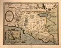
1603réf. 322945Antwerp: Abraham Ortelius 1603. Map. Engraving with beautiful hand coloring. Image measures 14" x 18". Beautiful 1603 map by Abraham Ortelius depicting Ancient Latium including Rome from his "Parergon". It covers Latium from the Tyrrhenian Sea to Umbria with parts of Tuscany and Campania. Cities are identified as individual buildings with particular focus on Rome its walls and notable buildings like the Coliseum. Notes mountains rivers marshlands and forests beautifully illustrated in profile. The map also includes historical and mythological elements such as a reference to Pliny in the Fucine Lake adding depth to the map's depiction of the region. Three cartouches adorn the map. The first is an ornate title cartouche in the upper right quadrant. Another is a dedication to Marcus Velser Augustanus. The third contains an inset of Mount Circeo the supposed dwelling place of the mythical goddess Circe who enchanted Odysseus and turned his companions into swine. This is the second state of the map identified by the addition of a network of roads around Rome and the designation of the swamp extended in the lower right along with the letters "VOLCI". The map is in good condition with some toning and minor abrasion loss near centerfold and verso repair near bottom margin. Van den Broecke #209. Abraham Ortelius 1527-1598 was a prominent Flemish cartographer geographer and cosmographer renowned for creating the first modern atlas "Theatrum Orbis Terrarum" which first appeared in 1570 and expanded over time to include 134 maps by 1592. Born in Antwerp he began his career as a map colorist and became a significant figure in cartography after being influenced by Gerard Mercator. His work was pivotal in the development of modern cartography integrating maps from various sources and reflecting his advanced geographical theories including early thoughts on continental drift. Appointed Royal Cartographer to King Philip II of Spain in 1575 Ortelius had access to extensive Spanish geographical knowledge. Despite the religious and political turmoil of his time he maintained a position of relative neutrality focusing on his scholarly and cartographic pursuits. His influential works also included "Synonymia Geographica" "Nomenclator Ptolemaicus" and "Parergon. Abraham Ortelius unknown
1624réf. 7958Antwerp: Plantin-Moretus 1624. Copper engraving 32.5 x 48 cms modern hand colour Latin text on verso. Latium the hinterland of ancient Rome. Van den Broecke notes a minor change in nomenclature which was made for the 1624 edition 209.3 which is not present here although our example was published by Balthasar Moretus at the Plantin Press in the final edition of the Parergon. Ortelius's Theatrum Orbis Terrarum is generally considered the first modern atlas of the world originally published in 1570. Ortelius gathered and selected the best available cartographic knowledge and presented it in a single volume duly credited and finely engraved in a consistent style with explanatory text. The Theatrum was very decorative and hugely popular amongst the wealthy and educated running into over forty editions in Latin and the major European languages. For Ortelius himself however his accompanying atlas of ancient geography the Parergon was a "personal work" Koeman. He seems to have regarded himself first and foremost as an antiquary and rather than copying other people's maps he drew the originals himself; they were subsequently engraved for him by the master engraver Jan Wierix. The results have to be evaluated as the most outstanding engravings depicting the wide-spread interest in classical geography in the 16th century Koeman. Koeman Atlantes Neerlandici Ort 46. Van den Broecke 209.2 Map Plantin-Moretus unknown
1603réf. 322945Antwerp: Abraham Ortelius 1603. Map. Engraving with beautiful hand coloring. Image measures 14" x 18". Beautiful 1603 map by Abraham Ortelius depicting Ancient Latium including Rome from his "Parergon". It covers Latium from the Tyrrhenian Sea to Umbria with parts of Tuscany and Campania. Cities are identified as individual buildings with particular focus on Rome its walls and notable buildings like the Coliseum. Notes mountains rivers marshlands and forests beautifully illustrated in profile. The map also includes historical and mythological elements such as a reference to Pliny in the Fucine Lake adding depth to the map's depiction of the region. Three cartouches adorn the map. The first is an ornate title cartouche in the upper right quadrant. Another is a dedication to Marcus Velser Augustanus. The third contains an inset of Mount Circeo the supposed dwelling place of the mythical goddess Circe who enchanted Odysseus and turned his companions into swine. This is the second state of the map identified by the addition of a network of roads around Rome and the designation of the swamp extended in the lower right along with the letters "VOLCI". The map is in good condition with some toning and minor abrasion loss near centerfold and verso repair near bottom margin. Van den Broecke #209. Abraham Ortelius 1527-1598 was a prominent Flemish cartographer geographer and cosmographer renowned for creating the first modern atlas "Theatrum Orbis Terrarum" which first appeared in 1570 and expanded over time to include 134 maps by 1592. Born in Antwerp he began his career as a map colorist and became a significant figure in cartography after being influenced by Gerard Mercator. His work was pivotal in the development of modern cartography integrating maps from various sources and reflecting his advanced geographical theories including early thoughts on continental drift. Appointed Royal Cartographer to King Philip II of Spain in 1575 Ortelius had access to extensive Spanish geographical knowledge. Despite the religious and political turmoil of his time he maintained a position of relative neutrality focusing on his scholarly and cartographic pursuits. His influential works also included "Synonymia Geographica" "Nomenclator Ptolemaicus" and "Parergon. Abraham Ortelius unknown books
1612réf. 30976Antwerp: Balthasar Moretus 1612. Other. In excellent condition. 356 by 453mm 14 by 17 inches. Original antique copper engraving from the 'Theatrum Orbis Terrarum' by Abraham Ortelius the world's first modern atlas published in Antwerp 1612. Depicting Rome & Latium this map is a fine example of 1610s European cartography. Image: 356 by 453mm 14 by 17 inches. An attractive and historically significant 17th-century map for the discerning collector. Abraham Ortelius 15271598 was a Flemish cartographer and geographer born in Antwerp. He is widely regarded as the creator of the first modern atlas the 'Theatrum Orbis Terrarum' Theatre of the World first published in 1570 by Gilles Coppens de Diest in Antwerp. Considered the world's first true atlas it established the modern format of uniform standardized maps bound together in a single volume. Appointed Geographer to King Philip II of Spain in 1575 Ortelius was one of the most influential figures in the history of cartography. His maps are held in the collections of the British Library the Library of Congress and major European institutions. The 'Theatrum' went through more than 30 editions and was translated into multiple languages making Ortelius's maps among the most sought-after in the world of antique cartography.The map is ornated with three cartouches in the upper left corner the title cartouche on the upper right side we find an oval text cartouche and in the lower left corner an inset. The privilegium is written on the lower right side. Villages and towns are shown as miniature views. Moreover the map is ornated with a ship.A fine example from Theatrum Orbis Terrarum Antwerp sought after by collectors of antique maps of Italy antique maps of Rome and antique copper engravings for sale. In good condition consistent with age. Light age-toning to the sheet as expected for a 17th-century engraving. Centerfold as published. Koe. Ort. 46; Broe: 209 state 2/2; Balthasar Moretus unknown
1669réf. 64891669 Amstelodami, sumptibus Andreae Frisii, [Amsterdam, Andrea Frisi], 1669. 3 parties en 1 vol. in-4: 18.5 x 24.5 cm [5] ff., [4] pl. grav. dép, 96 pp., [6] ff. d'index, [4] ff., 96 pp. Troisième et meilleure édition de ce curieux ouvrage, d'après Brunet, avec les gravures de la Table Isiaque d'après Enea Vico, absentes de précédentes éditions. Notre exemplaire comporte 43 gravures en taille-douce. Un frontispice gravés par Blooteling, 8 planches à pleine page, 26 figures dans le texte et 8 des 11 sections de la Table Isiaque réalisées par Giacomo Franco d'après les gravures de Vico parues en 1559, ces 8 sections sont regroupées en 4 grandes pl. dép. Il manque les 3 sections de la bande centrale de la table. Reliure de l'époque en parchemin. Dos lisse avec titre manuscrit à l'encre noir. Bel exemplaire