Alexandre-Edmond de Talleyrand-Périgord, 3ème Duc de DinoLivre Rare Book
711 risultati
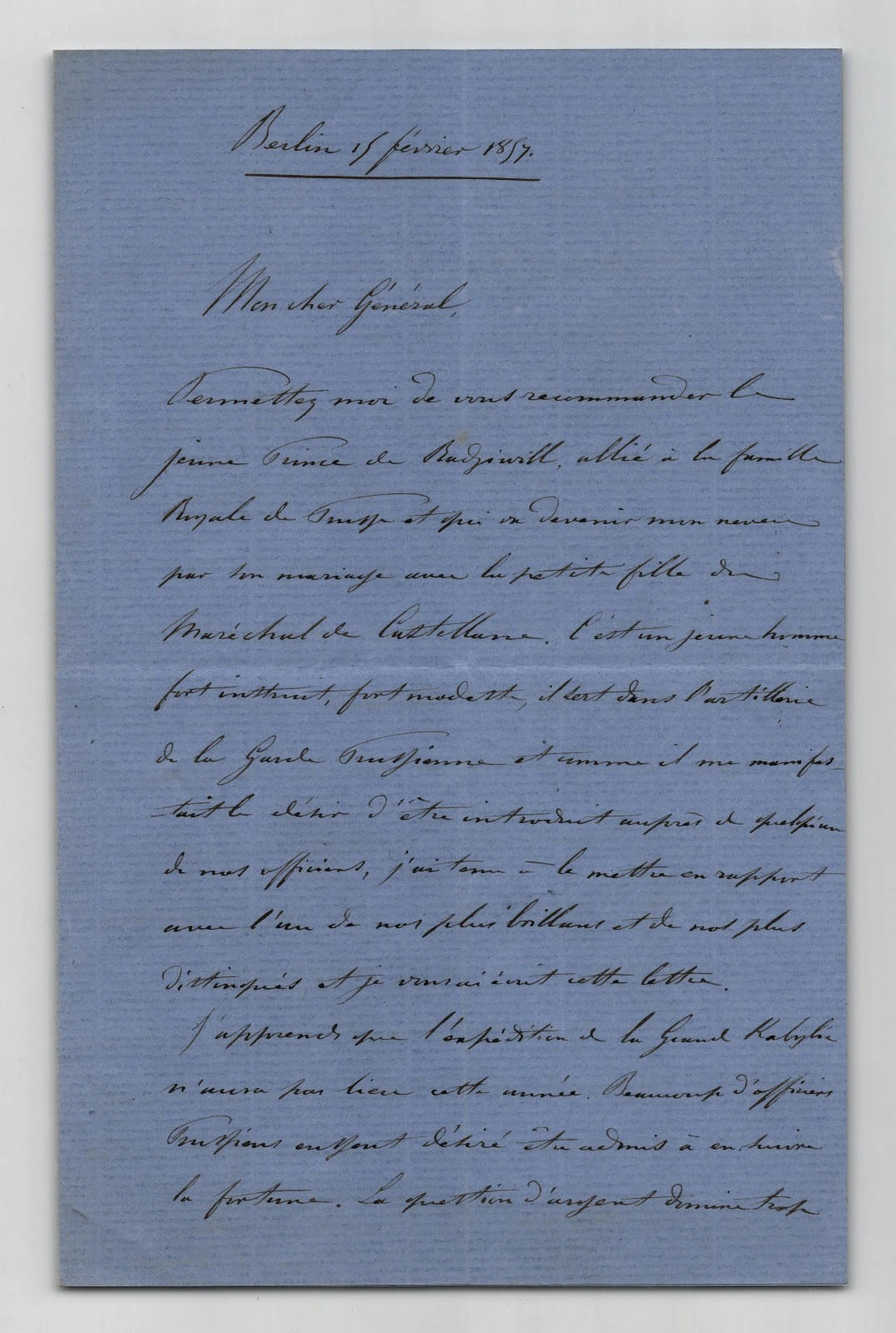
1857rif. boz_007158Lettre autographe signée d’Alexandre-Edmond de Talleyrand-Périgord, 3ème duc de Dino, petit-neveu de Talleyrand, qui servit pendant la guerre de Crimée. La lettre est datée de Berlin, le 15 février 1857. Elle est rédigée à l’encre noire sur double feuillet de papier vergé bleu. Elle est signée « Duc de Dino ». Dans cette lettre adressée à un général français, le duc de Dino recommande le jeune prince Antoine Radziwill, officier de l’artillerie de la Garde prussienne et futur époux de sa nièce Marie de Castellane, petite-fille du maréchal de Castellane. Il évoque le report annoncé de l’expédition de Grande Kabylie et l’intérêt des officiers prussiens pour l’armée française, et rappelle un souvenir commun de la Tchernaïa (écrit Tchernaya dans le texte) . Dimensions : 13,7 x 20,5 cm État : Bel état de conservation, plis inhérents à l'envoi. Voir photos et description pour plus de détails. Nombre de pages : 2 pages
1860In- 8 oblungo (mm 245 x 205), frontespizio, pp. 118 di testo e 40 tavole litografiche a colori (la n.39 dell'assedio di Peschiera non è mancante ma inserita come vignetta al frontespizio) e 2 carte delle battaglie di Magenta e Solferino comprese nel testo. Legatura mezza pelle, titolo e fregi oro al dorso.Titolo litografato a colori con vignetta, seguono la Prefazione, "Proclama di Napoleone III" stampato con caratteri oro su fondo blu. Testo descrittivo racchiuso entro cornice litografica (impressa in verde, blu, rosso, marrone) con motivi militareschi. Nell'indice dei ritratti al n.12 è indicato il Gen. Castelborgo, mentre al suo posto è presente il ritratto del Gen. Mollard. Edizione originale completa delle 62 incisioni (40 a colori, 20 ritratti su fondo ocra e 2 carte geografiche in b/n). Le belle tavole furono disegnate dal Bossoli ed eseguite in litografia da vari autori. Il ticinese Carlo Bossoli (1815-1884) pittore, disegnatore e litografo, fu inviato a seguito dell'esercito sardo nella guerra del 1859 e documentò con grande realismo gli episodi bellici. Il testo si basa sulle lettere dell'ungherese Nandor Eber, corrispondente per il Times. Questa importante raccolta di stampe a colori era stata pubblicata l'anno precedente a Londra con il titolo The war in Italy. Il successo di questo primo volume portò l'editore alla pubblicazione di una seconda parte, dedicata alle imprese di Garibaldi nelle due Sicilie e dell'Armata Piemontese di Vittorio Emanuele nelle Romagne e nel Napoletano.Qualche segno del tempo alla legatura, qualche macchietta e piccola arrossatura su alcune tavole, nel complesso ben conservato. . Abbey, J.R. Travel, 177 .
1990Very Good Turkish Paperback. Cr. 8vo. (20 x 14 cm). In Crimean Turkish (Cyrillic script). 222, [2] p., color ills. ISBN: 582501247. Akilli kirpinen ayneci tilki. Krimtatar halk masallari. Toplagan, islegen ve tertib etgen: Ablüziz Veliev. A rare fairytale book compiled and printed by Crimean intellectuals during their exile in Uzbekistan.
rif. 213850Paris, Charles-Lavauzelle, s.d. in-8, III-209 pp., 1 portr., 5 cartes dépl., toile rouge (rel. moderne).
rif. 215993Paris, Imprimerie Beaulé et Compagnie, s.d. (1854) placard in-folio (56 x 44 cm), texte sur 4 colonnes, en feuille.
1902411, (3 ads) pages. "This volume of war correspondence and travel bridges forty years of personal wanderings and adventure." - from Introductory. The adventures described took place in many places around the world. Here are the author's thoughts after a time in China: "The Chinese are noted for their savage cruelty. I had several instances, but I will not jar my readers' feeling by going into details of the Chinaman's 'gentle art' of disposing of his captive enemies. China, too, is the land of corruption. Every man considers it his duty to cheat his neighbour. It is a cardinal article of Celestial life. The process is known as 'squeezing' and, beginning with the Emperor, it is prosecuted down step-by-step." - from page 224. Unmarked. Somewhat above-average wear to publisher's red cloth adorned with gilt lettering. Binding intact. Moderate spine slant. Backstrip all but loose. (Prior owner secured it with tape, now moved, leaving some tackiness.) A worthy vintage copy. Book
Paris, Perrin et Cie Libraires-Editeurs, 1926, in-16, br. editoriale, pp. (4), 294, (2). Ottime condizioni.
Tratta da “Seat of War in the East”. Paul & Dominic Colnaghi & C.°, London 1855 – 1856. Tonolitografia in recente ma bella coloritura a mano, cm 37 x 55,5 circa (il foglio). Disponiamo di numerose tavole appartenenti alla prima o seconda serie. Le tavole sono tutte delineate da William Simpson e litografate da vari autori, tra cui E. Walker, J. Needham, T. Picken e altri. Tranne un minimo e lieve foxing, bella coloritura e in buono stato di conservazione.
1999New English Paperback. Roy. 8vo. (24 x 17 cm). In English. 192 p. A precarious balance: Conflict trade, and diplomacy on the Russian-Ottoman frontier.
20098vo., First Edition thus, with plates, small neat signature on front free endpaper; black cloth, gilt back, a near fine copy in unclipped dustwrapper. First published by John Murray in 1977. Turan 199 (recording the first edition).
1918Very Good Tatar Original wrappers. Demy 8vo. (21 x 14,5 cm). In Crimean Tatar in Arabic script. 25 p. Chipped on extremities, wear on spine, slightly stained and dusty covers. Overall a good copy. First and only edition of this first regulations consisting of 87 articles under 11 main headings, of the parliamentary (qurultai) of the Crimean People's Republic, which was the first Turkic and Muslim democratic republic in the world, existed from December 1917 to January 1918 in the Crimean Peninsula, a modern day Ukrainian territory currently occupied by the Russian Federation. The Crimean People's Republic was declared by the initiative of the Qurultai of Crimean Tatars, which stipulated the equality of all ethnicities within the peninsula. Noman Çelebicihan (1885-1918) was chosen as the first President of the nascent Republic. The Qurultai, in opposition to the Bolsheviks, published a "Crimean Tatar Basic Law", which convened an All-Crimean Constitutional Assembly, established a Board of Directors as a provisional government, and erected a Council of National Representatives as a provisional parliament. The Board of Directors and the Central Council of Ukraine both mutually recognized each other. This attempt to build a new nation was quickly defeated by the Bolshevik- and anarchist-dominated Black Sea Fleet. Already on 16 December 1917, the Bolsheviks captured Sevastopol where the headquarters of the Black Sea Fleet was located and dissolved the local council of deputies. The power in the city was transferred to the local revkom. The Bolsheviks were supported by some ships of the Black Sea Fleet. To defend itself, the Crimean government created a United Crimean Headquarters on 19 December 1917, that had at its disposal two cavalry and one infantry regiment of Crimean Tatars as well as some Ukrainian and Russian formations that amounted to some thousand people. Several armed incidents took place during January 1918. On 14 January 1918, the Bolsheviks captured Simferopol where they managed to arrest former President of Crimea (Head of Directorate) Noman Çelebicihan who had just resigned on 4 January 1918. He was transferred back to Sevastopol and interned until 23 February 1918, when he was executed without trial. The body of Çelebicihan was thrown into the sea. On the initiative of Çelebicihan on 10 January 1918, the Qurultai created a special commission that conducted talks with the Bolsheviks to stop the armed conflict in Crimea. On the initiative of Çelebicihan on 10 January 1918, the Qurultai created a special commission that conducted talks with the Bolsheviks to stop the armed conflict in Crimea. By the end of January 1918, the Bolsheviks had captured the whole of Crimea and dissolved both the Kurultai as well as the Council of National Representatives. The Red Terror engulfed the peninsula. With Çelebicihan in the Reds' custody, another leader of the Crimean Tatars, Cafer Seydamet Qirimer, managed to escape to the Caucasus across continental Ukraine. Many Crimean military formations retreated to the mountains. The government of Ukraine blockaded Crimea while trying to re-establish control over the Black Sea Fleet and the city of Sevastopol. Any Muslim supporting military formations on the way to Crimea was stopped. That, in turn, triggered a protest from the All-Russian Muslim military council. By the end of January 1918, the Ukrainian government itself was forced to declare war on the Russian SFSR due to the advancement of the Red Guard forces of Moscow and Petrograd into Ukraine without explicit notification. The Bolsheviks briefly established the Taurida Soviet Socialist Republic on Crimean territory in early 1918 before the area was overrun by forces of the Ukrainian People's Republic and the German Empire. Some officials of the national government, such as Seydamet Qirimer who managed to escape the Bolsheviks' terror sought political asylum in Kyiv and petitioned for military help from the advancing Ukrainian Army as w
1911Very Good Tatar Original wrappers. Roy. 8vo. (24 x 17 cm). In Tatar and Kiptchak Turkish with Arabic letters. 204, 4 p. Occasionally stains and foxing on covers, chipped upper margin on front cover. Otherwise a very good copy. First and only edition of Bigiev's work on fasting and feasts of Islam. In a broader sense, the book includes Muslim prayer and fasting in the northern regions of Russia, as well as ijtihad [i.e. Physical or mental effort, expended in a particular activity) is an Islamic legal term referring to independent reasoning or the thorough exertion of a jurist's mental faculty in finding a solution to a legal question], the creation of Adam, Dhu'l-Qarnayn [i.e. Alexander the Great], imitation, freedom of mind, comparison, and naskh issues are discussed. Bigiev (sometimes known as Luther of Islam), was a Tatar Hanafi Maturidi scholar, theologian philosopher, publicist, and one of the leaders of the Jadid movement. After receiving his education in Kazan, Bukhara, Istanbul, and Cairo, he became a political activist for the Ittifaq, the political organization of the Muslims of Russia. He also taught in Orenburg, wrote journalistic texts, and translated classic works into Tatar. After emigrating from the Soviet Union, he traveled Europe and the Middle and the Far East while writing and publishing. This is the early and one of his most important texts which include his ideas that have become his manifesto and thoughts as a leader of the Russian Muslims. In 1708, the Khanate of Kazan was abolished, and Kazan became the center of a guberniya. After Peter the Great's visit, the city became a center of shipbuilding for the Caspian fleet. The major Russian poet Gavrila Romanovich Derzhavin was born in Kazan in 1743, the son of a poor country squire of Tatar ancestry though himself having a thoroughly Russian identity. Kazan was largely destroyed in 1774 as a result of the Pugachev revolt, a revolt by border troops and peasants led by the Don Cossack ataman (captain) Yemelyan Pugachev, but was rebuilt soon afterward, during the reign of Catherine the Great. After the Russian Revolution of 1905, Tatars were allowed to revive Kazan as a Tatar cultural center. The first Tatar theater and the first Tatar newspaper appeared. On May 27, 1920, the Tatar Autonomous Soviet Socialist Republic of the RSFSR was declared. Under Joseph Stalin, the Soviet Union began to place restrictions on the use of the Tatar language, which used a variant of Arabic script. The Tatar alphabet switched to Cyrillic. OCLC 34253246, 83652445, 556971767.; TBTK 6143.; Özege 22332.
Very Good Turkish, Ottoman (1500-1928) Original color map. Atlas folio. (55 x 46 cm). In Ottoman script. Scale: 1/400.000. [OTTOMAN MAP of CAUCASIA] Yekaterinodar - Yeysk - Maykob - Anapa. Shows Krasnodar, Maikop, Yeysk, Anapa and shores of Black Sea. At northeast, map shows Kuban river (Kuban nehri) and its basin in Circassia (Republic of Adygea). Maykop is the capital city of the Republic of Adygea in Russia, located on the right bank of the Belaya River (a tributary of the Kuban River). Yekaterinodar (Krasnodar) at north of map, near to Maykop. From northwest to south east, map shows Black Sea shores of the extensive area with interesting details in Ottoman Turkish script. Also shown Belaya, Chokhrak and Dakh Rivers in addition all south land of Krasnodar Krai of the Northwestern Caucasus until southern Georgian borders and Georgia. Almost all toponyms are in Ottoman Turkish.
Very Good Turkish, Ottoman (1500-1928) Original color map. Elephant folio. (67 x 45 cm). In Ottoman script. Scale: 1/400.000. [OTTOMAN MAP of CAUCASIA] Shores of Black Sea / Batum - Poti. Shows Black Sea shores of Batum and Poti of Georgia. Mostly shown Black Sea in the map, but from southeast to northwest, a coastline reaches from Batum city to Adler (?). Some toponyms are in Turkish, but mostly Russian and Georgian in Arabic (Ottoman) script. A handsome and calligraphic Ottoman map.
1730Very Good Turkish, Ottoman (1500-1928) Original b/w map from Kitab-i Cihannuma which is one of the most important Turkish incunabula. Oblong large 4to. (31 x 37 cm). In Ottoman script. It shows Venice and Venetian Bay and Algerian shores at North Africa (Maghrib). Toponyms are in Turkish with Arabic letters. Written directions (Simal, Cenûb, Sark and Garb) on corners of the map, and decorative compass on Mediterranean Sea. Scale can be seen at left upper side (El-mikyas: Mil-i Islâmiyân Mil-i Frençe, and Mil-i Italiya]. It's one of the thirteen maps and plates from the book of Cihannuma. The story of Cihannuma can be considered as an effort to keep up with the speed that knowledge spread around the world at a time when literacy was highly limited. Kâtip Çelebi began to rewrite Cihannuma in 1654. During the next six years, he added to his books the knowledge he gained from the books he read. Kâtip Çelebi was vastly influenced by nonreligious positive knowledge, especially by the Atlas and later the Atlas Minor of Gerardus Mercator. He had the book translated from Latin to Turkish by a French recruit andenriched his own book with the new information. He brought together in Cihannuma the knowledge of geography and astronomy existing in Western sources (1654). Cihannüma has 13 charts and 27 maps. Mercator's maps are distinguished by their distinct properties. However, there are such maps which depict Istanbul, Anatolia, the Caucasus and the Orient that have to have been borrowed from other sources and there are those with relatively less detail that might have been prepared by Muslim geographers. Sources cite Ahmed El Kirimî (Ahmed the Crimean) and Galatali Migirdich as mapmakers for Cihannüma. Their names are placed on the maps. Another name that is mentioned is Tophaneli Ibrahim. Researchers agree on the fact that he is Ibrahim Müteferrika. Perhaps he wished to hasten the printing of the book. Perhaps he enjoyed making this contribution to a book he half owned. There is one map in Cihannüma which definitely does not belong to Mercator. Nor is there any information that it was originally charted by Müteferrika's team. Historians state that the 'invertedness' can be found in other maps made by Muslim cartographers. Since it is amap of Turkey, the difference can easily be perceived. The Mediterranean coasts of Turkey are at the top of the map while the Black Sea coasts are at the bottom. The compass on the map correctly indicates the North. The map seems to be inverted but it is not considered scientifically wrong to draw maps in this fashion...". (Source: Boyut; Kitab-i Cihannuma). Extremely rare.
Very Good Turkish, Ottoman (1500-1928) Original color map. Elephant folio. (60 x 50 cm). In Ottoman script. Scale: 1/300.000. [MAP of KRASNODAR - YEYSK] Yeysk. Bedlapaglia, Yekaterinodar, Anapa. Shows Yeysk, a port and a resort town in Krasnodar Krai, Russia, situated on the shore of the Taganrog Gulf of the Sea of Azov in north, Yekaterinodar (Krasnodar) in south, Anapa (Bigurkal) etc.
Very Good Turkish, Ottoman (1500-1928) Original color map. Elephant folio. (60 x 50 cm). In Ottoman script. Scale: 1/300.000. [MAP of KRASNODAR - YEYSK] Yeysk. Bedlapaglia, Yekaterinodar, Anapa. Shows Yeysk, a port and a resort town in Krasnodar Krai, Russia, situated on the shore of the Taganrog Gulf of the Sea of Azov in north, Yekaterinodar (Krasnodar) in south, Anapa (Bigurkal) etc.
Very Good Turkish, Ottoman (1500-1928) Original color map. Atlas folio. (66 x 46 cm). In Ottoman script. Scale: 1/400.000. [MAP of GEORGIA - SHORES of BLACK SEA] Batum, Keskim, Kutayisi. [Batoum, Kutaisi, Keskim]. Shows all toponym of shores of Black Sea of Georgia including Ottoman fortresses, villages etc. Not in TBMM Library Map Collection. Extremely rare.
Very Good Turkish, Ottoman (1500-1928) Original color map. Atlas folio. (55 x 46 cm). In Ottoman script. Scale: 1/400.000. [OTTOMAN MAP of CAUCASIA] Yekaterinodar - Yeysk - Maykob - Anapa. Shows Krasnodar, Maikop, Yeysk, Anapa and shores of Black Sea. At northeast, map shows Kuban river (Kuban nehri) and its basin in Circassia (Republic of Adygea). Maykop is the capital city of the Republic of Adygea in Russia, located on the right bank of the Belaya River (a tributary of the Kuban River). Yekaterinodar (Krasnodar) at north of map, near to Maykop. From northwest to south east, map shows Black Sea shores of the extensive area with interesting details in Ottoman Turkish script. Also shown Belaya, Chokhrak and Dakh Rivers in addition all south land of Krasnodar Krai of the Northwestern Caucasus until southern Georgian borders and Georgia. Almost all toponyms are in Ottoman Turkish.
rif. 214491Ll. dd., 1844-1872 27 pièces in-4, en feuilles, cousues.
2008Very Good Turkish Paperback. Demy 8vo. (21 x 14 cm). In Crimean Turkish (Cyrillic script). 278, [2] p. [H]ayatimin unutilmaz levhalari. Memoirs of a Crimean-Turkish intellectual.
1927Very Good Turkish, Ottoman (1500-1928) Modern black cloth, Arabic lettered gilt on spine. Roy. 8vo. (23 x 16 cm). In Ottoman script (Old Turkish with Arabic letters). 207 p. First edition of this extremely rare Turkish book, including Qirimi's first-hand account of the Prut War and Treaty (1711) and the defense of the city he participated in during the Russian invasion of Crimea (1735-36). The book was translated into Ottoman Turkish and edited by Turkish turcologist and soldier Necib Asim Yaziksiz, (1861-1935), with annotations, from the original work titled "Umdet al-Akhbar" [i.e. The principle of the news]. Abdulgaffar Qirimi was a Crimean scholar who lived in the Crimean Khanate in the first half of the 18th century and served in various government positions. Qirimi dedicated his work to Genghis Khan, the Golden Horde, and the Crimean Khanate. He reported many original details and, especially for the 18th century, his information is authentic and based on personal descriptions. The main part of the work is devoted to the Golden Horde (starting from Genghis Khan and his descendants), Crimean Khanate, Gerayids, and murzas. When Abdulgaffar Qirimi wrote a history of the descendants of Jochi Khan, he used in his book more than 20 historical works as sources. He stated the names of these works and indicated where he got this or that information. At the same time, he had access to the archives of the Crimean Khanate and used his family legends as well as popular traditions. Plenty of space in his work occupies his own observations as a participant in military campaigns and court life. His work concerning khans Berke, Tokhta, Uzbek, Tokhtamish, and Ulugh Muhammad reflects the popular version and is based on the oral historiography of the Tatars. The Russo-Ottoman War of 1710-1711, also known as the Prut River Campaign, was a brief military conflict between the Tsardom of Russia and the Ottoman Empire. The main battle took place during 18-22 July 1711 in the basin of the Pruth river near Stanile?ti (Stanilesti) after Tsar Peter I invaded Ottoman Moldavia, following the Ottoman Empire's declaration of war on Russia. The ill-prepared 38,000 Russians with 5,000 Moldavians, found themselves surrounded by 200,000 Turks under Grand Vizier Baltaci Mehmet Pasha. After three days of fighting and heavy casualties, the Tsar and his armies were allowed to withdraw after agreeing to abandon the fortress of Azov and its surrounding territory. The Ottoman victory led to the Treaty of the Prut which was confirmed by the Treaty of Adrianople. Özege 21999.; TBTK 479.; OCLC 281773486.
rif. 216012Paris, Lemercier, s.d. (1854) 3 cartes in-4 (32 x 44 cm), en feuilles.
2011New Turkish Paperback. 4to. (28 x 20 cm). Papers in Turkish (with various Turkic / Turkish dialects in Latin and Cyrillic script). 1086 p., b/w ills. 8. Uluslararasi Türk Dünyasi Sosyal Bilmler Kongresi: Türk dünyasinda muhtemel is birligi alanlari. 9-13 Haziran 2010, Celalabat-Kirgizistan. Sempozyum tebligleri. Many proceedings under these main chapters: Geography, religion, education, law, economics, art history, history, linguistics and philology.
1996rif. 291490PN. New. 1996. Soft Cover. Date is original print. This is a reprint edition . PN paperback


