The Ottoman Hejaz RailwayBiblio.com
9 687 résultats
1900réf. 00020910 p. Of text in English Ottoman Turkish Arabic Urdu and Russian with 9 full page plates. A hajj travel brochure printed in İstanbul supposed to be by an Armenian press in c. 1900. Rare An Armenian press paperback
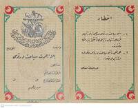
réf. 000177Ottoman Turkish script with crescent figures and map on the back of the Ottoman Railway. A free boarding pass should be declared on demand. Holder can carry up to 30 kg . 14.5 x 11 cm. Seruchin (?) An Armenian press
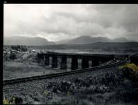
réf. 32483AB1974. Scotland 1974-2002. Oblong-Folio 44 cm wide x 36 cm high. Hardcover / Original Full-Leather Folders with stong black cardboards and original tissue-guards. Excellent condition with only minor signs of wear. With hundreds of manuscript annotations on the photography the photography-technique film used and with extensive elaborations on each photograph in these albums. More images on request ! Album 1: Covers the years 1974 1977 and 1978. The West Highland Line is walked from Arrochar a 1977 driving and camping holiday and a 1978 seventeen day touring holiday with many nights sleeping in a car fill the leaves with c. 200 b/w original photographs. Album 2: Covers the years 1991 and 1992. It is noted that 1990 is the fourth year that returning locomotives from the Mallaig line will work south over the West Highland main line. Images of Corrour Summit Glasgow to Fort William trains and many many more bridges viaducts tunnels stations and signalling equipment fill the leaves. c.182 b/w original photographs. Album 3: Covers 1993. More colour photographs now fill the leaves and annotations cease to second half of album. c 270 b/w colour and tinted original photographs. Album 4: Covers 1999 and 2002. Many images from The Highlands Rail Festival in Sept 1999. c.250 b/w and colour original photographs. An extraordinary photographic record and passion project presented in 4 huge well-bound albums containing over 900 fine photographs taken curated and annotated by an unidentified railway enthusiast and talented photographer. The albums span 4 decades recording trips to some of the most scenic and famous rail locations in the UK. The West Highland Line is returned to again and again over the decades and our photographer captures Scotlands most dramatic landscapes and railways as the route passes on its way from Glasgow to Mallaig through sections including Corrour and Rannoch Moor. Albums and contents in fine condition. A tissue guard between every leaf protects the photographs within. A single photograph of a middle aged man among every other photograph which records a detail of the railway is the only clue to the albums previous ownership and perhaps authorship. Partial description by our colleague Dr.Christian White from Christian White Rare Books in Ilkley UK. __________________________________________________________________________________________________________ The West Highland Line Scottish Gaelic: Rathad Iarainn nan Eilean "Iron Road to the Isles" is a railway line linking the ports of Mallaig and Oban in the Scottish Highlands to Glasgow in Central Scotland. The line was voted the top rail journey in the world by readers of independent travel magazine Wanderlust in 2009 ahead of the notable Trans-Siberian line in Russia and the Cuzco to Machu Picchu line in Peru. The ScotRail website has since reported that the line has been voted the most scenic railway line in the world for the second year running. The West Highland Line is one of two railway lines that access the remote and mountainous west coast of Scotland the other being the Kyle of Lochalsh Line which connects Inverness with Kyle of Lochalsh. The line is the westernmost railway line in Great Britain. At least in part the West Highland Line is the same railway line as that referred to as the West Highland Railway. History: The route was built in several sections: Glasgow Queen Street to Cowlairs Junction - Edinburgh and Glasgow Railway Cowlairs Junction to Bowling - Glasgow Dumbarton and Helensburgh Railway later absorbed into the Edinburgh and Glasgow Railway Bowling to Dumbarton Central - Lanarkshire and Dumbartonshire Railway operated by the Caledonian Railway Dumbarton Central to Dalreoch - Caledonian and Dumbartonshire Junction Railway Dalreoch to Craigendoran - Glasgow Dumbarton and Helensburgh Railway Craigendoran to Fort William opened 11 August 1894 - West Highland Railway sponsored by the North British Railway Crianlarich to Oban - Callander and Oban Railway operated by the Caledonian Railway. There is an additional section from Fort William or a junction near Fort William to Mallaig built as the Mallaig Extension Railway. The West Highland Railway approved the construction of the line at their annual meeting in January 1895. The line faced potential closure as part of the Beeching cuts in 1963 and again in 1995 due to reduced revenues. Route description: Shortly after leaving Glasgow Queen Street station and beyond Queen Street Tunnel the line diverges from the main trunk route to Edinburgh Waverley and Perth at Cowlairs and follows a northwesterly course through the suburbs of Maryhill and Kelvindale. Between Westerton and Dumbarton the route is shared with the North Clyde Line to Helensburgh Central before branching northward at Craigendoran Junction towards Garelochhead the section where the West Highland Line itself is generally accepted to begin. It gives high-level views of the Gare Loch and Loch Long before emerging alongside the northwesterly shores of Loch Lomond then climbs Glen Falloch to Crianlarich. The branch to Oban diverges at Crianlarich an important Highland junction of both road and rail and runs through Glen Lochy to Dalmally and through the Pass of Brander to reach salt water at Taynuilt and Connel Ferry before a final climb over a hill to Oban. About three miles five kilometres from Crianlarich the Mallaig and Oban routes both pass through the village of Tyndrum but they are served by separate stations making it an unusually small settlement to be served by more than one railway station. After Bridge of Orchy the line to Mallaig climbs onto Rannoch Moor past the former crossing point at Gorton Crossing to Rannoch station. In winter the moor is often covered with snow and deer may be seen running from the approaching train. The station at Corrour on the moor is one of the most remote stations in Britain and is not accessible by any public road. This is the summit of the line at 1347 ft 410 m above sea level. Carrying on northwards the line descends above the shores of Loch Treig and through the narrow Monessie Gorge. The final stop before Fort William is Spean Bridge. The section between Fort William and Mallaig passes over the Glenfinnan Viaduct through Arisaig with its views of the Small Isles of Rùm Eigg Muck and Canna and the white sands of Morar before coming to Mallaig itself. With the exception of the route between Glasgow Queen Street and Helensburgh Upper and the short section between Fort William Junction and Fort William station the railway is signalled using the Radio Electronic Token Block controlled from the signal box at Banavie station. Notable railway-related features Glenfinnan Viaduct The Horse Shoe Curve between Upper Tyndrum and Bridge of Orchy The Cruach Rock snowshed between Rannoch and Corrour Glenfinnan Viaduct between Locheilside and Glenfinnan The Pass of Brander stone signals between Dalmally and Taynuilt Arisaig is the most westerly railway station in Great Britain West Highland Line in film: Train crossing bridge at Banavie The summit of the line just north of Corrour Glenfinnan Viaduct on the line between Fort William and Mallaig is a filming location for the Hogwarts Express in the Harry Potter series of films. Eddie McConnell's poetic documentary A Line for All Seasons 1970 showcases the line and its history set against the scenery of the western highlands as it changes through the seasons. Corrour features in Trainspotting 1996 directed by Danny Boyle. Source: Wikipedia hardcover
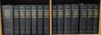
1861réf. 55725Washington DC: Beverley Tucker; A. O. P. Nicholson; George W. Bowman; Thomas H. Ford 1861. Mixed Senate and House editions. Leather bound. Very Good. Twelve volumes in thirteen books Volume twelve in two parts plus one thick volume with the following title in gilt on the spine: "Explorations and Surveys for a Railroad Route from the Mississippi River to the Pacific Ocean. General Report." Large quartos 30 cm Bound in modern black leather with the title stamped in gilt on the spines and blind-tooled embellishments on the spines and boards. "Senate" and "House" stamped in gilt at the head of the spines. "War Department" stamped at the foot. New endpapers. Spines of a couple volumes a bit faded. Sporadic foxing and toning throughout though a large majority of the color lithographs remain in excellent condition. Stitching periodically visible in the inside margins. Occasional moisture stains other light stains and darkening to the pages. Tide mark staining more frequent in volume VI and the General Report. Volumes VIII and XII Book 1 are ex-library with discreet markings. Volume XI with maps and plates is heavily foxed at the beginning mostly affecting the text. This volume contains Warren's great map. Many of the large maps and profiles are fragile and have many splits normally encountered in these kinds of sets. "General Map of Explanations and Surveys in California" in Volume XI completely detached from binding but present. With 665 illustrated plates 64 maps/sections/profiles and 15 diagrams. Collation Notes: Volume II: 12 scenic plates one nearly detached; 20 botanical plates; 4 geological plates; 1 large folding map; 1 large folding geological section. Volume III: 12 scenic plates; 7 diagrams; 8 Native American plates missing illustration titled "Pictographs at Yampais Spring"; 3 geological plates; 2 folding sections and 1 folding map at the rear. Not present in this volume: "General Map from Fort Smith to Rio Del Norte" "General Map from Rio del Norte to the Pacific Ocean" and "Profile of a route for the Pacific Railroad from Fort Smith to Martinez." Volume IV: 1 large folding botanical plate with explanation of signs; 24 plates related to Cacti; 25 other botany plates; 10 plates devoted to Mosses and Liverworts. Volume V: 12 views; 4 maps; 14 sections; 13 views missing plate XII- "Mirage on the Colorado Desert"; 11 fossil and shell plates missing plate X; 28 botany plates. Volume VI: 13 General Report plates; 5 geology plates; 14 botany plates missing Plate I- "Quercus Hindsii"; missing plate X- "Juniperus occidentalis"; 11 fish plates; 3 mammal plates; 2 bird plates. Volume VII: 8 scenic plates; 10 paleontological plates; 14 geological plates; 2 fold-out maps; 8 botanical plates; 11 meteorological plates. Volume VIII: 20 mammal plates plates XVII-LX. Volume X: 33 reptile plates missing plate VI- "Dipsosaurus dorsalis Hallow & Sceloporus biseriatus Hallow"; reptile plate II mislabeled as III; 51 fish plates; 9 mammal plates plate XI- "Sciurus fremonti Towns" mislabeled as plate VI; plate VIII- "Lepus audubonii Baird" mislabeled XIII; 28 bird plates. Volume XI: 4 map plates; 13 sketches of Route of Forty-First Parallel- Beckwith's Report Vol. II; Warren Map plus 31 maps and profiles. Volume XII Book I: 70 lithographs. Volume XII Book II: 6 botany plates; 2 insect plates; 5 mammal plates missing plate VIII- "Texas Mouse etc."; 8 bird plates; 10 reptile plates; 21 fish plates. Some fish plates that are listed in Volume XII Book II as being present in Volume X appear to be absent LXXVI XXVb XXV XXVI LXX LXXV. General Report: 8 diagrams; 3 large folding maps/profiles at rear one with tape repairs- "Milk R. to the Crossing of the Columbia R."; 120 illustrated plates lacking "View of Fort Smith" and "Pictographs at Yampais Spring". No general title page. A mixed Senate and House set in attractive modern leather bindings. The quarto edition of the Pacific Railroad Reports first appeared in 1855 and concluded in 1861 with volume XII. The Surveys aimed at determining the best route for a transcontinental railroad. It embodied the most comprehensive information source on the American West in the mid-19th century. Numerous illustrators engravers lithographers cartographers and printing firms contributed to the publication. This monumental work is rarely found in such nice condition. ".it was the best cartographical work on the West up to its time." - Wright Howes. ".these volumes contain a monumental collection of scientific information geographical zoological botanical geological of the still mysterious American West." - Henry Wagner. Howes P3. Moffat 3536 & 49. Wagner/Camp 262-267 pp. 468-507. Beverley Tucker; A. O. P. Nicholson; George W. Bowman; Thomas H. Ford unknown
1861réf. 55725Washington DC: Beverley Tucker; A. O. P. Nicholson; George W. Bowman; Thomas H. Ford 1861. Mixed Senate and House editions. Leather bound. Very Good. Twelve volumes in thirteen books Volume twelve in two parts plus one thick volume with the following title in gilt on the spine: "Explorations and Surveys for a Railroad Route from the Mississippi River to the Pacific Ocean. General Report." Large quartos 30 cm Bound in modern black leather with the title stamped in gilt on the spines and blind-tooled embellishments on the spines and boards. "Senate" and "House" stamped in gilt at the head of the spines. "War Department" stamped at the foot. New endpapers. Spines of a couple volumes a bit faded. Sporadic foxing and toning throughout though a large majority of the color lithographs remain in excellent condition. Stitching periodically visible in the inside margins. Occasional moisture stains other light stains and darkening to the pages. Tide mark staining more frequent in volume VI and the General Report. Volumes VIII and XII Book 1 are ex-library with discreet markings. Volume XI with maps and plates is heavily foxed at the beginning mostly affecting the text. This volume contains Warren's great map. Many of the large maps and profiles are fragile and have many splits normally encountered in these kinds of sets. "General Map of Explanations and Surveys in California" in Volume XI completely detached from binding but present. With 665 illustrated plates 64 maps/sections/profiles and 15 diagrams. Collation Notes: Volume II: 12 scenic plates one nearly detached; 20 botanical plates; 4 geological plates; 1 large folding map; 1 large folding geological section. Volume III: 12 scenic plates; 7 diagrams; 8 Native American plates missing illustration titled "Pictographs at Yampais Spring"; 3 geological plates; 2 folding sections and 1 folding map at the rear. Not present in this volume: "General Map from Fort Smith to Rio Del Norte" "General Map from Rio del Norte to the Pacific Ocean" and "Profile of a route for the Pacific Railroad from Fort Smith to Martinez." Volume IV: 1 large folding botanical plate with explanation of signs; 24 plates related to Cacti; 25 other botany plates; 10 plates devoted to Mosses and Liverworts. Volume V: 12 views; 4 maps; 14 sections; 13 views missing plate XII- "Mirage on the Colorado Desert"; 11 fossil and shell plates missing plate X; 28 botany plates. Volume VI: 13 General Report plates; 5 geology plates; 14 botany plates missing Plate I- "Quercus Hindsii"; missing plate X- "Juniperus occidentalis"; 11 fish plates; 3 mammal plates; 2 bird plates. Volume VII: 8 scenic plates; 10 paleontological plates; 14 geological plates; 2 fold-out maps; 8 botanical plates; 11 meteorological plates. Volume VIII: 20 mammal plates plates XVII-LX. Volume X: 33 reptile plates missing plate VI- "Dipsosaurus dorsalis Hallow & Sceloporus biseriatus Hallow"; reptile plate II mislabeled as III; 51 fish plates; 9 mammal plates plate XI- "Sciurus fremonti Towns" mislabeled as plate VI; plate VIII- "Lepus audubonii Baird" mislabeled XIII; 28 bird plates. Volume XI: 4 map plates; 13 sketches of Route of Forty-First Parallel- Beckwith's Report Vol. II; Warren Map plus 31 maps and profiles. Volume XII Book I: 70 lithographs. Volume XII Book II: 6 botany plates; 2 insect plates; 5 mammal plates missing plate VIII- "Texas Mouse etc."; 8 bird plates; 10 reptile plates; 21 fish plates. Some fish plates that are listed in Volume XII Book II as being present in Volume X appear to be absent LXXVI XXVb XXV XXVI LXX LXXV. General Report: 8 diagrams; 3 large folding maps/profiles at rear one with tape repairs- "Milk R. to the Crossing of the Columbia R."; 120 illustrated plates lacking "View of Fort Smith" and "Pictographs at Yampais Spring". No general title page. A mixed Senate and House set in attractive modern leather bindings. The quarto edition of the Pacific Railroad Reports first appeared in 1855 and concluded in 1861 with volume XII. The Surveys aimed at determining the best route for a transcontinental railroad. It embodied the most comprehensive information source on the American West in the mid-19th century. Numerous illustrators engravers lithographers cartographers and printing firms contributed to the publication. This monumental work is rarely found in such nice condition. ".it was the best cartographical work on the West up to its time." - Wright Howes. ".these volumes contain a monumental collection of scientific information geographical zoological botanical geological of the still mysterious American West." - Henry Wagner. Howes P3. Moffat 3536 & 49. Wagner/Camp 262-267 pp. 468-507. Beverley Tucker; A. O. P. Nicholson; George W. Bowman; Thomas H. Ford unknown books
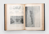
1900réf. 164829Istanbul: Ahmed hsan 1900-06. The birth of the Hejaz railway First editions first printings of 82 issues of this influential Ottoman magazine notably with illustrated reports covering the establishment of the Hejaz Railway between 1901 and 1906. Striking images include the transportation of the track itself from Beirut Issue 547 the inauguration of the line between Dar'a and Muzayrib Issue 553 and an inspection of the line by the governor of Damascus Issue 555. Numerous issues contain images charting the progress of the construction. The documentary quality of these pictures is particularly unusual. In Issue 688 for example the front cover depicts a group of Ottoman soldiers at work at Haifa station on the railway's Palestinian branch line while the cover of Issue 701 shows Sultan Abdülhamid II inspecting the section from Damascus to Ma'an on the anniversary of his accession. These latter images were taken by a special reporter appointed by the magazine. Servet-i funün began to be published in 1891 under the direction of its owner Ahmed hsan and continued its activities until 1944. It occupies a special place within the history of Turkish periodicals of which it was considered the most intellectual. Initially an illustrated supplement of the newspaper Servet it took on a more literary character from 1895 when the editorship was handed to Tevfik Fikret and printed the work of famous contemporary writers including Cenab ehabeddin Halit Ziya Mehmed Rauf and Ali Ekrem. Despite these literary leanings the magazine maintained robust coverage of current affairs as is evinced by the political supplements and the many documentary images of contemporary events in the Ottoman Empire which are found in these issues. Volume 22 contains the consecutive issues 547-572 and the unnumbered volume holds issues 599-625 followed by the political supplements to issues 599-624. The last bound volume contains the consecutive issues 781-806 followed by the political supplements to each issue. The unbound issues are 507 687 688 696 and 701. Folio 335 x 235 mm 3 bound vols and 5 unbound issues. Bound vols: one vol. in contemporary half brown morocco rebacked retaining original title lettering piece spine with raised bands unnumbered cloth sides; two vols in contemporary sheep spines with raised bands gilt lettered direct both numbered in gilt in third compartment "22" and "31" cloth sides. Unbound issues: spines hand stitched and sometime strengthened with paper. Gilt stamp of "Doctor Essad" at foot of spine of vol. 31. Lacking a few leaves only: pp. 211-2 from supplement to vol. 31; pp. 133-4 161-2 and 187-8 from political supplements of unnumbered volume. Unnumbered volume: Judiciously restored contents with faint damp stains at ends and margins creased in places repair to p.41 with clear tape. Numbered vols: Extremities judiciously repaired and strengthened scuffed and recoloured in places some stripping of leather and wear to edges minor loss to spine of vol. 31 some issues printed on lighter paper stock. Unbound issues: four issues with neat recent repairs to spines occasional light damp staining one issue with repaired tear to front wrapper and a few small holes throughout. Overall some toning mild scattered foxing or staining and a few marginal tears or chips. A good set overall. hardcover
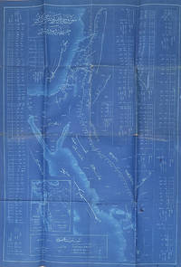
1915réf. 00024286x59 cm. Prepared by Ashraf Eşref - the draftsman of the technical department of the Hejaz Railway Title: Şam'dan Medine-i Münevvere Hattı Haritası Map of the Railway Line from Damascus to Medina. Date: 1331 1915 Scale: 1:2100000 clearly printed in the title cartouche. Language and script: Ottoman Turkish in Arabic script. Printing method: Cyanotype blueprint identified by the deep blue background with white lines and lettering. The map covers the entire Hejaz Railway route including: Damascus Şam Daraa Amman Ma'an Tabuk Madâin Sâlih Al-'UlÄ Medina Medine-i Münevvere It also depicts: The branch line to Haifa on the Mediterranean. The Gulf of Aqaba and the Red Sea. The Sinai Peninsula. Important towns wadis and geographic features along the railway. Insets and vertical profiles showing elevations along sections of the railway. This was an engineering and operational map prepared for the Ottoman administration of the Hejaz Railway. The elevation profiles and detailed station information indicate that it was intended for railway planning and operation rather than for general public use. Technical Department of the Hejaz Railway
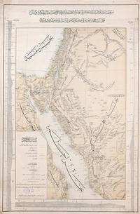
1903réf. 163825Constantinople: Matba'a-i Bahriye "The Press of the Navy" 1319 Rumi 1903. Mapping the great Hejaz Railway the embodiment of Hamidian Pan-Islamism A rare and important official map depicting the route of the Hejaz Railway based on a manuscript drafted under the supervision of the "brilliant Turkish engineer" Hadji Mukhtar Bey Maunsell p. 585 who served as the chief of operations. It was issued in 1903 while the main line from Damascus to Medina was still under construction but after the final route had been established. This detailed large-format map covers most of Syria all of Palestine the Sinai Peninsula the Suez Canal and all the north-western Arabian Peninsula. It delineates those parts of the railway that are in place and those under construction with each station labelled. Additionally it depicts the two alternative routes proposed for extending the line to Mecca as well as the proposed but unrealized route of a rail line from Mecca to the port of Jeddah. The map also labels important roads and caravan routes. In September 1907 four years after publication of this map the railway reached AlUla. Although AlUla is not marked here Mada'in Salih modern al-Hijr/Hegra is present which was a significant station responsible for the maintenance of locomotives. Mada'in Salih was UNESCO's first World Heritage Site in Saudi Arabia and comprises "a major site of the Nabataean civilization in the south zone of its influence" UNESCO. Construction of the Hejaz Railway began in 1901 and by 1908 had reached Medina 400 km short of Mecca where for various political reasons it had to be terminated. Until the outbreak of the First World War it allowed hundreds of thousands of pilgrims to make the hajj in safety and with relative ease. For the first time branch lines provided a rapid link from Syria to Palestine. The moving figure behind this map was the veteran military engineer Hadji Mukhtar Bey who had conducted "military-scientific expeditions in east Africa Harrar and the Somali coast in the 1870s and early 1880s producing the first 'correct' cartographic maps of the region" El Shakry p. 42. It was he along with fellow officer Ali Rida al-Rikabi later first prime minister of modern Syria who originally assessed the route when they joined the 1900 hajj. Initial field surveys for the present map were conducted by two Ottoman cavalry officers Captain Umar Zaki and Lieutenant Hasan Mu'ayyin. In an interesting article in Jerusalem Quarterly Zeynep Celik and Zeinab Azarbadegan pay particular attention to this map and note that the Ottoman Navy "produced different versions of the map in Arabic and Ottoman Turkish pointing to the multiple purposes and audiences targeted within and beyond the empire. The mass production of maps demonstrates the Ottoman state's attempt to disseminate cartographic knowledge about the empire to the public. This speaks to the third and final aspect of analysis of the Hejaz Railway: its use as a tool of Ottoman state propaganda during the Hamidian era". There are at least two states of this map with slightly different titles. Colour lithographic map 800 x 520 mm coastal profiles of the Red Sea in left and right margins script in Ottoman Turkish. Light vertical creasing throughout minor foxing publisher's stamp in the cartouche marginal small tears repaired with old paper. A very good example. Zeynep Celik & Zeinab Azarbadegan "Late Ottoman Visions of Palestine: Railroads Maps and Aerial Photography" Jerusalem Quarterly 82 Summer 2020; Lieut.-Col. F. R. Maunsell "The Hejaz Railway" The Geographical Journal Vol. 32 No. 6 Dec. 1908; Omnia El Shakry The Great Social Laboratory: Subjects of Knowledge in Colonial and Postcolonial Egypt 2007. unknown
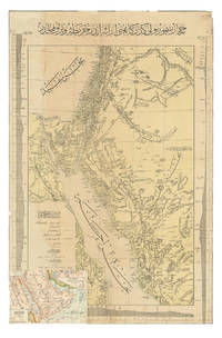
1904réf. ABC_47091Constantinople: Matba a-i Bahriye 1904. Colour-lithographed map 76.5 x 49.5 cm trimmed to neat line. A rare separately issued official railway map with the entire text in Ottoman Turkish depicting the route of the Hejaz Railway. Following a route proposed by the eminent Turkish engineer Mukhtar Bey and surveyed by the cavalry officers Umar Zaki and Hasan Mu'ayyin the epic project funded by subscriptions from the global Islamic faithful completed a rail link from Damascus to Medina by 1908. The present map shows the intended continuation to Mecca never completed. Although it went no further south than Medina the railway nevertheless briefly allowed many thousands of pilgrims to make the Hajj in relative comfort bringing them to Medina and within about 300 km of Mecca. It shows the northern half of the Red Sea the Sinai peninsula the southeast corner of the Mediterranean Sea and what were to become Palestine most of Jordan and parts of Lebanon and Syria.A contemporary Ottoman colour-lithographed map of the Arabian Peninsula has been pasted over the lower left corner below the key like an inset map hiding only a tiny bit of the main maps topographic image. Old folds and creases some small tears repaired tiny chips to neat line some light stains. Some remnants of tape and old private collector's stamps on the back. Still in good condition. Matba a-i Bahriye, unknown
1902réf. 00011029 × 20 cm. Comprising 158 text plates including 95 photographs produced by the committee of which 42 photographs appear on separate plates measuring approximately 23 × 15 cm. The work documents the Photography Committee's journey from Istanbul to MaÊ¿Än in Transjordan. The accompanying text was compiled from articles originally published without illustrations in various issues of the newspaper Vakit "Time" in 1902. This is a unique work prepared for publication with photographs taken by a private committee that included prominent figures such as the German general Karl Auler Pasha who served as an adviser on Hejaz affairs until the fall of Medina in 1918. hardcover
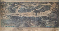
1910réf. 000240This remarkable collection relating to the Hejaz Railway includes; 1 An original signed oil painting by its artist together with the handwritten memoirs of an Ottoman officer and a manuscript route diagram indicating the railway's distances measurements and train itinerary. The oil painting measures 91 × 51 cm and was executed in oil by Hajj Muhammad Firaqi Ayyubi signed and dated 31 Dhu al-Qa'dah 1328 AH 1910 CE. The painting presents an exceptionally detailed panoramic representation of the Hejaz Railway illustrating every station along the line together with the geographical character of its surroundings including villages and towns. It depicts the railway's natural setting—mountains seas valleys city walls and tunnels—as well as symbolic representations of urban buildings moving trains distances between stations branch railway lines government buildings in selected towns and military forts. Rich in topographical and historical detail the work functions as a visual book portraying the Hejaz Railway as though it were seen in reality. An extensive explanatory text in Ottoman Turkish occupies the lower section of the painting describing the purpose of the work and the method by which it was produced. Particular attention is devoted to regions such as Haifa Rayak Aleppo and Mada'in Salih with references to their ancient history the historic pilgrimage route and the Imperial Surre the Ottoman annual caravan carrying gifts and financial endowments to the Holy Cities. The title prominently inscribed at the center of the lower section reads: "General View of the Hejaz Railway from Medina al-Munawwara to Noble Damascus Drawn According to the Principles of Cartography." This is a unique and previously unrecorded example combining artistic excellence cartographic precision and historical documentation in a single work. 2 Manuscript Memoirs of an Ottoman Officer: A Modest Journey from Istanbul to Medina This manuscript comprises the handwritten memoirs of an Ottoman officer named Kehyâzâde Mehmed Ali Cevad entitled A Modest Journey from Istanbul to Medina. It consists of 100 pages with most pages containing 19 lines of text and measures 18.5 × 11.5 cm. The manuscript is illustrated with several original hand-drawn plans including: a full-page plan of the Hejaz Railway station at al-Marjah Marjeh Damascus; a plan of a fortress near Kilometer 760 in the al-Akhdar region of northern Arabia; a plan of al-Mu'azzam Station at Kilometer 827; another plan at Mabrakat al-NÄqah around Kilometer 918; a sketch of one of the monumental gateways of MadÄ'in á¹¢Äliḥ near Kilometer 1049; and an unfinished two-page plan of the Prophet's Mosque al-Masjid al-Nabawi in Medina. The manuscript also contains a separate second section independent from the Hejaz Railway memoirs written by another Ottoman officer who was the brother of the author of the first section. This part records the return journey from Istanbul to Bandırma and İzmir following the author's return from the Hejaz. The memoir opens with an account of the political and social conditions in Istanbul following the deposition of Sultan Abdülhamid II. It then narrates the journey on the Hejaz Railway beginning on 18 April 1325 Ottoman Fiscal Calendar and continuing until 2 May 1325. The author records the journey in remarkable detail following the railway kilometer by kilometer. He describes the geographical landscape topography architectural features the condition of the railway stations the railway line and its extensions as well as the demographic social and regional characteristics of the areas traversed. He also notes the prevailing weather conditions and carefully records place names and distances continuing his observations up to Kilometer 1299 in Medina where he provides a particularly detailed description of the city's railway station architecture and principal landmarks. These memoirs constitute an exceptionally rare example of an Ottoman travel account devoted to the Hejaz Railway distinguished by its meticulous documentation of the railway its stations and the surrounding landscape. 3 A Hejaz Railway Train Operations Table effective 25 July 1328 Ottoman Fiscal Calendar measuring 61 × 45 cm. The chart records the elevations of the terrain between each pair of stations above sea level the topographical characteristics of the route the distances in kilometres and the function of each station with particular detail given to the principal stations from Mada'in Salih through Al-'Ula Al-Bada'i and Al-Hadiyyah to Medina. The table also sets out the train timetable over a 24-hour period indicating movements on the main line and the station sidings branch tracks. In addition it illustrates the track junction and turnout configurations at every station along the route.
réf. 2658Lausanne, Impr. Centrale,1943 ; 8°, broché.