1 128 résultats
1890Very Good Arabic Original hand-colored map on tissue paper. 23x19 cm. In Ottoman script and Arabic. No scale. Manuscript notes of toponyms. The manuscript shows Egypt, Ethiopia, Sudan, the Red Sea along the line of Red Sea shores. Manuscript notes show that the map was used for military purposes in the last Ottoman Imperial period. Habesh Eyalet, Ethiopia in northeast Africa was conquered by Özdemir Pasha in 1557. His son, Osman Pasha, transformed the region into an eyalet, which remained under Ottoman suzerainty until the early 19th century when Egypt assumed its administration. (Source: Pashas, Begs, Effendis: A historical dictionary of titles and terms in the Ottoman Empire, Bayerle, Gustav.).
1991réf. LFA-126740207N° 266 (Mars 1991) : 72 pages, format 215 x 285 mm, illustré, broché couverture couleurs, bon état
1991réf. LFA-126740214N° 274 (Décxembre 1991) : 78 pages, format 215 x 285 mm, illustré, broché couverture couleurs, bon état
1997réf. LFA-126746946N° 340 (Décembre 1997) : revue de 78 pages, format 215 x 285 mm, illustrée, brochée couverture couleurs, bon état
2001réf. LFA-126746971N° 374 (Janvier 2001) : revue de 78 pages, format 215 x 285 mm, illustrée, brochée couverture couleurs, bon état
2003réf. LFA-126746985N° 397 (Février 2003) : revue de 78 pages, format 215 x 285 mm, illustrée, brochée couverture couleurs, bon état
2004réf. LFA-126746999N° 411 (Mai 2004) : revue de 90 pages, format 215 x 285 mm, illustrée, brochée couverture couleurs, bon état
2004réf. LFA-126747004N° 417 (Décembre 2004) : revue de 82 pages, format 215 x 285 mm, illustrée, brochée couverture couleurs, bon état
2005réf. LFA-126747008N° 426 (Octobre 2005) : revue de 82 pages, format 215 x 285 mm, illustrée, brochée couverture couleurs, bon état
2004réf. LFA-126719570Revue trimestrielle fondée par Raymond Aron : 288 pages, format 185 x 255 mm, brochée, bon état
2003réf. LFA-126719714N° 288 (Novembre 2003): 86 pages, format 215 x 285 mm, illustré, broché couverture couleurs, bon état
2009réf. LFA-126719722N° 334 (Juillet-août 2009): 96 pages, format 215 x 285 mm, illustré, broché couverture couleurs, bon état
réf. 200801798Paris, Gallimard découvertes, 2004 ; in-8, 158 pp., broché,couverture imprimée.
réf. 201010229Paris, Le cherche midi éditeur, 2001 ; in-8, 222 pp., broché, couverture illustr (pt écornement). Bon état.
2024réf. LFA-126747611Revue de 98 pages, format 200 x 260 mm, illustrée, brochée couverture couleurs, publiée en 2024, Historia, bon état
réf. 201007394Paris, Revue internationale et stratégique, 2004 ; in-8, 177 pp., broché, couverture illustr. N° spécial - 53 - printemps 2004.
réf. 201302923Paris, Presses de la renaissance, 2006 ; in-8, 184 pp., br.
réf. 201221196Paris, Presse de la renaissance , 2006 ; in-8, 183 pp., br.
réf. LFA-126741875Une carte format 430 x 520 mm, s.d. (début du XXe siècle), bon état
réf. 200919117Paris, C.L.D., 2003 ; in-8, 283 pp., broché, couverture illustr.
réf. 200809760Paris, Hugo Doc, 2005 ; in-8, 174 pp., broché, couverture illustr. Chesnot, malbrunot, al jouni, aubenas, hamoun al saasi.
réf. 201104336Paris, Oh édition, 2005 ; in-8, 700 pp., broché, couverture illustr. Préface de Bernard Kouchner - très bon état.
réf. 200904957Paris, Oh édition, 2005 ; in-8, 700 pp., broché, couverture illustr. Préface de Bernard Kouchner.
réf. 26975'Published by Survey Directorate G.H.Q. Paiforce 1944. All one page 20 x 33cms some stained but texts clear and complate. 1. Index map of Iraq and Iran for a 1:100000 scale survey series produced by the British military command PAIFORCE during World War II. All 20 x 32.5cm a couple sl. stained mainly good condition.1.Four Index maps of Iraq and Iran ¼ series I.D.R./X.D.R./G.S.G.S. 9002 3919 nos. 1-42.Index map of Iraq and Iran for a 1:100000 scale survey series produced by the British military command PAIFORCE during World War II. Index Map of 'Irq rn 1:100000 Series I.D.R. 9003'.3.Four Index Maps of places/areas of IRAN:a. Ahwaz 1:10000 series 1D MISC/563 to 573 stamped 11 June 1944b. Askaran and Sanandaj N.W. 1:25000 series …9005 stamped 25 June 1944c. Gach-I-Sar 1:50000 series stamped 11 June 1944d. Khurramshahr Abandan 1:12500 series4.Six Index Maps of places/areas of IRAQ all 1:25000 series ID 9005:a. Ba'qubab. Faidahc. Haffad. Hindiyae. Falluja f. MoselNo reference to other copies yet found. 'Published by Survey Directorate, G.H.Q. Paiforce [1944] unknown
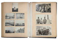
1912réf. JBDEH1HAEOMM1912. 1/4 leather album. 4to. Approximately 120 mounted usually 2-4 to a page snap shots ranging in size from 60 x 40 mm to 120 x 100 mm. Brief captions in black ink under almost all the photos. The first half of the photos show middle class life in Edwardian England. The second and more interesting half of the photos are snap shots that appear to have been taken by a British officer and include military subjects scenes of Baghdad and the Euphrates and views of the Bosporus.An early 19th century photograpic impression of middle class life in England and the military in Iraq Some photos are faded or have minor spots or light streaks. Wretched-looking lacking backstrip with covers worn discolored and detached. hardcover