6 355 résultats
1869réf. PE107911869 16 p., 1 folded lithographed plate, disbound (no covers). Unopened copy. Published in: Sitzungsberichte der Kaiserlichen Akademie der Wissenschaften. Scarce.
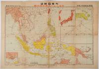
1719réf. 219230東京. Tokyo.: 日本放送協会. Nihon Hōsō Shuppan Kyōkai. Showa 17 1942. Colour folding map scale 1: 10000000 54.7cm x 79.5cm chronology of building the Greater East Asia Co-Prosperity Sphere on reverse. Some light browning a little darker at folds and reverse washi repairs to folds on reverse. This colour map of Asia and the Pacific published on 30 January 1942—just one month after Japan's attack on Pearl Harbor—offers a striking glimpse into wartime strategy and propaganda. Remarkably despite being produced at the war's outset it accurately anticipated key battlegrounds that would define the conflict. The main map is supplemented by two inset maps: one in the upper right highlighting Japan the Hawaiian Islands and Honolulu and another in the lower left focusing on Singapore with Darwin marked along the lower edge. The reverse side features a revealing chronological chart titled "Building Great East Asia" documenting Japan's military expansion from the 1931 Manchurian Incident through January 1942 as troops advanced across Southeast Asia. Notably two blank rows were intentionally left at the chart's end anticipating future victories to be recorded as the war progressed—a telling detail that underscores the map's dual role as both strategic document and propaganda tool. An interesting map which combines geographical precision with ideological messaging. . 日本放送協会. [Nihon Hōsō Shuppan Kyōkai]. unknown
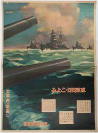
1619réf. 176888東京. Tokyo.: 東京日日新聞社. Tōkyō Nichinichi Shinbunsha. Showa 16 1941. Colour poster from a 1941 calendar. 53.5 x 38.5cm small holes at corners central horizontal fold. Some light even browning but overall a striking WWII image from a Japanese calendar. This colour illustrated calendar shows the months of March April and May 1941. The illustration features four Japanese war ships at sea with two naval guns in the foreground. The calendar is titled "Rough Sea on the Pacific Ocean". The implication being military threats are coming from across the Pacific. . 東京日日新聞社. [Tōkyō Nichinichi Shinbunsha]. unknown
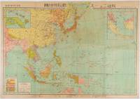
1719réf. 176771東京. Tokyo.: 日本放送出版会社. Nihon Hōsō Shuppan Kaisha. Showa 17 1942. Colour folding map scale 1:14500000 55cm x 80cm naval warship photographic illustrations on reverse. The wartime paper is browned and friable but small closed tears along fold lines and edges have been neatly repaired with archival washi on the verso. 79 x 53cm This colour map of Asia and the Pacific was published as a supplement to a magazine Hoso 放送 on January 1942 less than one month after the Pearl Harbor attack by the Japanese Forces. The war had just started but amazingly the map accurately predicted where the fighting would take place throughout the war. An inset map on upper right shows Singapore Borneo Sumatra and Java where battles took place in the area in early 1942. An inset chart on lower left shows various resources and their location including coal tin and iron ore clearly showing that the war was fought over securing resources. On reverse eleven photographic illustrations of war ships from Germany Britain the US and Japan are shown including the Prince of Wales and Enterprise. . 日本放送出版会社. [Nihon Hōsō Shuppan Kaisha]. unknown
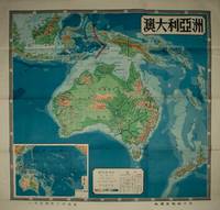
1954réf. 224585上海 Shanghai.: 地圖出版社 Ditu chubanshe. 1954. Coloured topographical map of the Australian continent inluding Papua New Guinea and New Zealand 106 x 112cm text in traditional Chinese characters. Legend includes desert coral reef seasonal rivers and lakes continental boundaries and so on. Inset map of Australia and the Pacific Islands also with key indicating altitude and sea depth. Folds into lightly worn original paper envelope measuring 38 x 25.5cm. Pinholes upper right and left corners small hole at fold point and tear in upper margin now repaired with archival washi paper 澳大利亞handwritten on reverse. Both envelope and the reverse of the map have small production labels attached. Map very bright with clear strong colours. Striking map in very good condition. . 地圖出版社 [Ditu chubanshe]. unknown