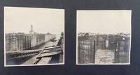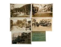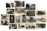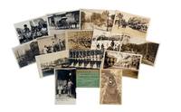
1910ref. 226891910. Early twentieth-century Panama photo archive circa 1910s to 1920s documents Panama during the decades surrounding the completion and early operation of the Panama Canal supporting research into U.S. engineering influence urban modernization Indigenous representation tourism waterfront labor and the transformation of Panama City and Colón into canal-era commercial spaces. The Panama Canal was completed and opened in 1914 linking the Atlantic and Pacific through one of the period's most consequential engineered waterways and the Gatun Locks formed part of the lock system that lifted vessels to Gatun Lake before lowering them at the opposite end of the route. These photographs record not only canal machinery and civic streets but also the human geography around the canal: tourists workers traders children waterfront activity ruins and leisure businesses appear together in a visual record of Panama's modernization under strong American commercial and infrastructural presence. Fifteen pieces comprising fourteen silver gelatin photographs and real photo postcards with one printed business advertisement card Panama circa 1910s to 1920s measuring approximately 2½ x 3¾ inches to 4 x 6 inches. The canal views include "Operating Emergency Dam Gatun Locks Panama Canal" and a view captioned "Gatun Locks" showing massive steel gates and early twentieth-century bridgework. Urban scenes include "Street Scene Panama City on Southern Cruise 1923" with American tourists Model T automobiles and colonial façades and "The Plaza Panama City" showing palm trees streetcar tracks and civic space. Local and historical subjects include a real photo postcard captioned "Circular Stairway in Old Panama ruins of Old Panama standing at the foot and looking directly up" documenting Panama Viejo the site of the original Panama City founded in 1519 and later recognized as part of a UNESCO World Heritage site. Other images include "Panama Water Front at High Tide" with fishing boats and market activity; dockworkers and traders near the canal's edge; and "Children in San Blas Panama" foregrounding Indigenous presence during the Canal era. The San Blas Islands are associated with the Guna an Indigenous people of Panama and Colombia whose communities are strongly identified with Guna Yala and the San Blas archipelago. The advertisement card reading "When in Colon Visit the Café Hollywood" places the photographic group within the leisure and service economy that grew around canal traffic tourism and foreign presence. Together the images clarify the different but connected worlds of early twentieth-century Panama: the engineered landscape of Gatun Locks the colonial and modern streets of Panama City the ruins of Old Panama the working waterfront Indigenous children in San Blas and the commercial culture of Colón. Minor corner wear and toning; images sharp and well preserved very good overall. Cohesive Panama Canal era archive documenting the intersection of American engineering urban transformation Indigenous life waterfront labor and tourist commerce in the early decades of the Canal Zone. unknown books
1910ref. 226891910. Early twentieth-century Panama photo archive circa 1910s to 1920s documents Panama during the decades surrounding the completion and early operation of the Panama Canal supporting research into U.S. engineering influence urban modernization Indigenous representation tourism waterfront labor and the transformation of Panama City and Colón into canal-era commercial spaces. The Panama Canal was completed and opened in 1914 linking the Atlantic and Pacific through one of the period's most consequential engineered waterways and the Gatun Locks formed part of the lock system that lifted vessels to Gatun Lake before lowering them at the opposite end of the route. These photographs record not only canal machinery and civic streets but also the human geography around the canal: tourists workers traders children waterfront activity ruins and leisure businesses appear together in a visual record of Panama's modernization under strong American commercial and infrastructural presence. Fifteen pieces comprising fourteen silver gelatin photographs and real photo postcards with one printed business advertisement card Panama circa 1910s to 1920s measuring approximately 2½ x 3¾ inches to 4 x 6 inches. The canal views include "Operating Emergency Dam Gatun Locks Panama Canal" and a view captioned "Gatun Locks" showing massive steel gates and early twentieth-century bridgework. Urban scenes include "Street Scene Panama City on Southern Cruise 1923" with American tourists Model T automobiles and colonial façades and "The Plaza Panama City" showing palm trees streetcar tracks and civic space. Local and historical subjects include a real photo postcard captioned "Circular Stairway in Old Panama ruins of Old Panama standing at the foot and looking directly up" documenting Panama Viejo the site of the original Panama City founded in 1519 and later recognized as part of a UNESCO World Heritage site. Other images include "Panama Water Front at High Tide" with fishing boats and market activity; dockworkers and traders near the canal's edge; and "Children in San Blas Panama" foregrounding Indigenous presence during the Canal era. The San Blas Islands are associated with the Guna an Indigenous people of Panama and Colombia whose communities are strongly identified with Guna Yala and the San Blas archipelago. The advertisement card reading "When in Colon Visit the Café Hollywood" places the photographic group within the leisure and service economy that grew around canal traffic tourism and foreign presence. Together the images clarify the different but connected worlds of early twentieth-century Panama: the engineered landscape of Gatun Locks the colonial and modern streets of Panama City the ruins of Old Panama the working waterfront Indigenous children in San Blas and the commercial culture of Colón. Minor corner wear and toning; images sharp and well preserved very good overall. Cohesive Panama Canal era archive documenting the intersection of American engineering urban transformation Indigenous life waterfront labor and tourist commerce in the early decades of the Canal Zone. unknown
1907ref. 10701Paris, Dunod et Pinat, 1907 ; in-8, broché ; (4), 305, (3) pp., grande planche dépliante (profils en long des 3 projets), figures et 11 planches hors-texte dont 2 plans et 9 photographies, couverture brique imprimée.
PARIS, Hachette, 1886 - In-4 - Reliure 1/2 basane à coins - Dos à nerfs - 1 plat fragilisé - Couverture conservée - Envoi manuscrit de l'auteur au Colonel Marchand (*) - frontispice, 399 pages + Table - Bien complet des cartes plans et tableau synoptique des divers projets PARIS, Lib. A. Heymann - 1891 - Couverture conservée - Grande carte dépliante in-fine - 154 pages - rousseurs éparses POISSY, imp; Typ. de S. Lejay & cie - 1893 - couverture conservée - 54 pages - Bon exemplaire - Envoi rapide et soigné (*) Jean-Baptiste Marchand , Thoissey, 22 novembre 1863 , Paris, 13 janvier 1934, Mlitaire et Explorateur, célèbre pour avoir commandé la mission Congo-Nil.
ref. 27874PARIS, Hachette, 1886 - In-4 - Reliure 1/2 basane à coins - Dos à nerfs - 1 plat fragilisé - Couverture conservée - Envoi manuscrit de l'auteur au Colonel Marchand (*) - frontispice, 399 pages + Table - Bien complet des cartes plans et tableau synoptique des divers projetsPARIS, Lib. A. Heymann - 1891 - Couverture conservée - Grande carte dépliante in-fine - 154 pages - rousseurs éparses POISSY, imp; Typ. de S. Lejay & cie - 1893 - couverture conservée - 54 pages - Bon exemplaire - Envoi rapide et soigné
ref. 136457aafs.d. (ca. 1882 ?), photo: 26 x 39 cm. construction avec locomotif et ouvriers (noirs), sans aucun indication. montées sur carton gris (36 x 49 cm.)
1904ref. 182051904. Photograph album circa 1904-1914 documenting maritime activity canal construction and social life in Panama during the period of American engineering control of the Panama Canal project. The images center on a group of American men traveling aboard a small yacht identified in several photographs by the presence of the American yacht ensign indicating a private pleasure vessel rather than a military or commercial ship. Several photographs appear to show large-scale excavation and infrastructure consistent with canal construction situating the album within the decade of intensive labor and engineering that culminated in the canal's completion in 1914. Alongside these scenes are numerous images of local life including Indigenous children and adults along coastal and riverine environments as well as built landscapes featuring plantation-style houses adapted to tropical climates. The album provides visual evidence of the intersection of American presence large-scale infrastructure development and local communities in early twentieth-century Panama. Photograph album containing images mounted on black pages within a black leather-bound volume measuring approximately 10 x 7 inches and comprising 86 pages. The photographs depict shipboard life including crew members steering and managing vessels group portraits of men in bathing attire and social gatherings such as shared meals. Additional images show coastal scenes with canoes swimmers and shoreline activity as well as occasional figures in military dress. The composition of the album reflects both travel documentation and informal social photography capturing a range of maritime domestic and environmental subjects. 86-page album with photographs mounted throughout; one page partially clipped and one page removed with small tears to several pages not affecting images. Light sunning to some photographs; overall very good condition. A cohesive visual record of American maritime travel and canal-era activity in Panama documenting both infrastructure development and everyday life in the region. unknown books
1915ref. 224481915. Unknown photographer Panama Canal Zone and local life photo archive 1915 documents Panama during the first year after the canal's opening to traffic and supports research into U.S. imperial administration Canal Zone settlement travel photography military protection of infrastructure and the visual ordering of colonial space. The Panama Canal opened to traffic on August 15 1914 after U.S. construction created a strategic interoceanic route administered through the Canal Zone and Balboa Heights became a key administrative and residential center for the U.S.-controlled canal system. These photographs capture the built and natural environment through which American authority was made visible: locks river landscapes official buildings hilltop housing city views and naval practice appear together as evidence of a recently completed engineering project becoming an occupied administrative territory. Twenty-four original silver gelatin photographs including two real photo postcards dated 1915 with some undated images several with handwritten inscriptions in English on versos and some with printed captions on rectos. Photographs measure approximately 3½ x 5 inches to 5½ x 7 inches. The archive includes views of the Chagres River the largest river in the Panama Canal drainage basin and a major part of the canal water system together with photographs of the Gatun Locks canal gates aerial views of Panama City the main city plaza a bull ring and Balboa Heights. The Balboa Heights images show American-style bungalows arranged along curving terraced roads with broad verandas raised foundations and landscaped grounds visual evidence of the residential hierarchy attached to U.S. canal administration. Additional images show the Administration Building at Balboa Heights completed in 1914 and positioned above the town as a central administrative landmark while a real photo postcard captioned "Ready to Fire-Division Practice" shows U.S. naval boats in formation off the coast connecting sightseeing views to the military protection of the newly opened canal. The archive's research value lies in its combination of personal travel documentation official-looking captioned views urban and infrastructural scenes and military imagery from the early Canal Zone era. Its views of Balboa Heights are especially significant because U.S. canal society was organized through racialized and occupational distinctions including the "gold roll" and "silver roll" labor categories that separated white American workers from largely Black Caribbean and Latin American workers and shaped housing pay and privilege within the zone. Light edge wear legible inscriptions and preserved image surfaces very good overall. Cohesive Panama Canal Zone photo archive documenting the immediate post-opening landscape of U.S. power in Panama through canal infrastructure river systems segregated administrative space urban views and naval readiness. unknown books
1904ref. 182051904. Photograph album circa 1904-1914 documenting maritime activity canal construction and social life in Panama during the period of American engineering control of the Panama Canal project. The images center on a group of American men traveling aboard a small yacht identified in several photographs by the presence of the American yacht ensign indicating a private pleasure vessel rather than a military or commercial ship. Several photographs appear to show large-scale excavation and infrastructure consistent with canal construction situating the album within the decade of intensive labor and engineering that culminated in the canal's completion in 1914. Alongside these scenes are numerous images of local life including Indigenous children and adults along coastal and riverine environments as well as built landscapes featuring plantation-style houses adapted to tropical climates. The album provides visual evidence of the intersection of American presence large-scale infrastructure development and local communities in early twentieth-century Panama. Photograph album containing images mounted on black pages within a black leather-bound volume measuring approximately 10 x 7 inches and comprising 86 pages. The photographs depict shipboard life including crew members steering and managing vessels group portraits of men in bathing attire and social gatherings such as shared meals. Additional images show coastal scenes with canoes swimmers and shoreline activity as well as occasional figures in military dress. The composition of the album reflects both travel documentation and informal social photography capturing a range of maritime domestic and environmental subjects. 86-page album with photographs mounted throughout; one page partially clipped and one page removed with small tears to several pages not affecting images. Light sunning to some photographs; overall very good condition. A cohesive visual record of American maritime travel and canal-era activity in Panama documenting both infrastructure development and everyday life in the region. unknown
1915ref. 224481915. Unknown photographer Panama Canal Zone and local life photo archive 1915 documents Panama during the first year after the canal's opening to traffic and supports research into U.S. imperial administration Canal Zone settlement travel photography military protection of infrastructure and the visual ordering of colonial space. The Panama Canal opened to traffic on August 15 1914 after U.S. construction created a strategic interoceanic route administered through the Canal Zone and Balboa Heights became a key administrative and residential center for the U.S.-controlled canal system. These photographs capture the built and natural environment through which American authority was made visible: locks river landscapes official buildings hilltop housing city views and naval practice appear together as evidence of a recently completed engineering project becoming an occupied administrative territory. Twenty-four original silver gelatin photographs including two real photo postcards dated 1915 with some undated images several with handwritten inscriptions in English on versos and some with printed captions on rectos. Photographs measure approximately 3½ x 5 inches to 5½ x 7 inches. The archive includes views of the Chagres River the largest river in the Panama Canal drainage basin and a major part of the canal water system together with photographs of the Gatun Locks canal gates aerial views of Panama City the main city plaza a bull ring and Balboa Heights. The Balboa Heights images show American-style bungalows arranged along curving terraced roads with broad verandas raised foundations and landscaped grounds visual evidence of the residential hierarchy attached to U.S. canal administration. Additional images show the Administration Building at Balboa Heights completed in 1914 and positioned above the town as a central administrative landmark while a real photo postcard captioned "Ready to Fire-Division Practice" shows U.S. naval boats in formation off the coast connecting sightseeing views to the military protection of the newly opened canal. The archive's research value lies in its combination of personal travel documentation official-looking captioned views urban and infrastructural scenes and military imagery from the early Canal Zone era. Its views of Balboa Heights are especially significant because U.S. canal society was organized through racialized and occupational distinctions including the "gold roll" and "silver roll" labor categories that separated white American workers from largely Black Caribbean and Latin American workers and shaped housing pay and privilege within the zone. Light edge wear legible inscriptions and preserved image surfaces very good overall. Cohesive Panama Canal Zone photo archive documenting the immediate post-opening landscape of U.S. power in Panama through canal infrastructure river systems segregated administrative space urban views and naval readiness. unknown
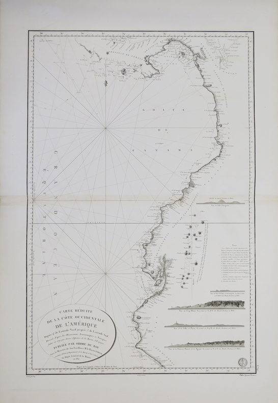
1821ref. LBW-37141821. 846 x 562 mm.
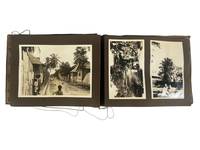
1930ref. 224461930. Caribbean and Panama travel photograph album. circa early 1930s. This album documents interwar travel through the Panama Canal Zone and Jamaica recording maritime transit canal infrastructure and rural Caribbean life as observed by Western travelers. The photographs provide primary visual evidence of the Panama Canal as a site of industrial activity and international movement alongside scenes of Jamaican village life and landscape establishing a contrast between engineered environments and colonial rural settings. The material is particularly strong in its depiction of canal operations and the presence of local populations within these spaces. Album containing 29 silver gelatin photographs mounted on black leaves with individual prints measuring approximately 3.5 x 4.5 to 5 x 7 inches housed in a string-bound album measuring approximately 7 x 9.5 inches. The opening sequence shows passengers aboard a steamship with men and women posed along deck rails and views of ships navigating canal locks and docking areas. Additional images depict cranes drawbridges canal cuts and small boats in the water along with dock workers and uniformed personnel visible among travelers. Architectural and infrastructural views include colonial-style buildings and mechanical equipment associated with canal operation concluding with a monument identified as that of Vasco Núñez de Balboa in Panama City. The Jamaica sequence includes landscape views of hillsides and gardens along with images of Black Jamaican residents posed in village settings. One photograph bears the caption "Kingston Jamaica 10 -- S.S. 'Reliance' West Indies Cruise" showing children and adults gathered along a dirt road lined with wooden and metal-roofed structures. Other images show groups assembled beneath trees and within rural surroundings. Produced during a period when the Panama Canal served as a major conduit for global shipping under U.S. administration and Caribbean travel formed part of organized cruise itineraries the album reflects established routes of interwar tourism. The juxtaposition of canal engineering and Jamaican village scenes situates the photographs within broader patterns of travel that linked industrial infrastructure with colonial landscapes. Minor water rippling to pages and photographs; images remain clear; overall very good. A coherent travel album documenting canal operations and Caribbean life in the early twentieth century. unknown books
1930ref. 224461930. Caribbean and Panama travel photograph album. circa early 1930s. This album documents interwar travel through the Panama Canal Zone and Jamaica recording maritime transit canal infrastructure and rural Caribbean life as observed by Western travelers. The photographs provide primary visual evidence of the Panama Canal as a site of industrial activity and international movement alongside scenes of Jamaican village life and landscape establishing a contrast between engineered environments and colonial rural settings. The material is particularly strong in its depiction of canal operations and the presence of local populations within these spaces. Album containing 29 silver gelatin photographs mounted on black leaves with individual prints measuring approximately 3.5 x 4.5 to 5 x 7 inches housed in a string-bound album measuring approximately 7 x 9.5 inches. The opening sequence shows passengers aboard a steamship with men and women posed along deck rails and views of ships navigating canal locks and docking areas. Additional images depict cranes drawbridges canal cuts and small boats in the water along with dock workers and uniformed personnel visible among travelers. Architectural and infrastructural views include colonial-style buildings and mechanical equipment associated with canal operation concluding with a monument identified as that of Vasco Núñez de Balboa in Panama City. The Jamaica sequence includes landscape views of hillsides and gardens along with images of Black Jamaican residents posed in village settings. One photograph bears the caption "Kingston Jamaica 10 -- S.S. 'Reliance' West Indies Cruise" showing children and adults gathered along a dirt road lined with wooden and metal-roofed structures. Other images show groups assembled beneath trees and within rural surroundings. Produced during a period when the Panama Canal served as a major conduit for global shipping under U.S. administration and Caribbean travel formed part of organized cruise itineraries the album reflects established routes of interwar tourism. The juxtaposition of canal engineering and Jamaican village scenes situates the photographs within broader patterns of travel that linked industrial infrastructure with colonial landscapes. Minor water rippling to pages and photographs; images remain clear; overall very good. A coherent travel album documenting canal operations and Caribbean life in the early twentieth century. unknown
1879Précieux tiré à part des Comptes rendus des séances de l'Académie des Sciences qui constitue l'acte de naissance du tracé du canal de Panama. "L'opuscule reproduit le discours lu par Ferdinand de Lesseps le 2 juin 1879, où il plaide en faveur de l'exécution de son projet de construction du canal interocéanique au Panama, et du lancement d'un appel national de capitaux s'élevant à 400 milions de francs. Lesseps évoque les études faites par Wyse et Reclus, lieutenants de vaisseau, et Celler, ingénieur en chef des Ponts et Chaussées, ainsi que plusieurs autres ingénieurs étrangers envoyés par une société d'études française.Il parle enfin de la seconde exploration de Wyse et Reclus et de leur projet, "parfaitement étudié" qui fixe le tracé du canal entre Colon-Aspinwal et Panama en suivant le tracé du chemin de fer sur une ligne de 73 km." Cf Catalogue vente Zoummeroff, Piasa, 2005.
1825ref. 368803Burdeos Bordeaux: en casa de Lawalle Jóven y Sobrino 1825. 155pp. 12mo. Modern red morocco and cloth front cover off original printed wrappers bound in. 155pp. 12mo. Bolivar propose the Congress which took place in 1826. en casa de Lawalle Jóven y Sobrino unknown books
1825ref. 368803Burdeos Bordeaux: en casa de Lawalle Jóven y Sobrino 1825. 155pp. 12mo. Modern red morocco and cloth front cover off original printed wrappers bound in. 155pp. 12mo. Bolivar propose the Congress which took place in 1826. en casa de Lawalle Jóven y Sobrino unknown
(Al fin:) Aranjuez a 23 de Abril de 1768, 30 x 19 cm., hol. piel moderna con puntas, 3 folios. (Es obra muy rara. El catálogo Colectivo registra sólo dos ejemplares).
1911Features: Steel Bridge Across Chehalis River at Aberdeen Formally Opened - article with photo; The Panama Canal Route for Canadian Northwest Shipping; Photo of Charles M. Hays, president of the Grand Trunk Railway; Address to General Passenger Agents by Howard Elliott, president of the Northern Pacific Railway (four pages); Brief business biography of George W. Hibbard, General Passenger Agent of the C.M. & P.S., with photo; Bernard N. Baker's Steamship Line a Golden Opportunity; Puget Sound Tugboat Co. on the Columbia River; New Boilers for North Vancouver Ferries; Steamer Maunganui Launched; Review of the Charter Market; Casualties to Pacific Coast Shipping; Modern Aids to Navigation Demanded for Alaskan Waters - article including lengthy list of vessels lost; Excellent illustrated centerfold makes the case for lighthouses in Alaskan waters; Review of Marine Insurance and Shipping Law; Address by president of the San Francisco Merchants' Exchange, Robert Dollar, entitled "The American Merchant Marine As It Affects Our Foreign Commerce" - with photo of Dollar; and more. 44 pages including several pages of nostalgic ads, some illustrated in black and white, featuring local marine and rail interests. Printed upon glossy coated stock. Average wear. Binding intact. Few library markings to front cover. A well-preserved copy of this highly-informative memento of Pacific Northwest transportation over a century ago. 12" x 9". Magazine
1911Features: Reasons Why the Canadian Pacific is So Prosperous; Spokane Rate Decision Eagerly Awaited; Value of Steel Equipment Demonstrated in Wreck of the Crack Milwaukee Train, Columbian on May 30th east of Ralston, WA; Continued Smuggling of Opium into West Coast Ports Aboard Trans-Pacific Steamships; Professional Biography of Joseph H. Young, President of Alaska Steamship Co. - with photo; Contracts Let for Coaling Plants in Seattle and Tacoma - article with two photos; $1 Million Available for Improvements at Moran Shipyards; Record Run Between Puget Sound and Callao by Schooner Wilbert L. Smith; After 20 Years on the Seattle-Tacoma Run, Steamer Flyer is Sold - Feature article with photo; Review of Marine Insurance and Shipping Law; Photo of Steamer Tampico Submerged in Seattle Harbor; Photo of New Boilers for Steamer Charmer built by Commercial Boiler Works of Seattle; Effects of the Panama Canal on Pacific Coast - Oriental Trade; News of Tacoma; Launching of the Titanic - 1/3 page article including photo of the Titanic in drydock with man standing below her massive 100-ton rudder; Charming one-page illustrated ad for The Shasta Limited, "The Finest Train in the West" which connected Seattle with San Francisco; and more. 44 pages including several pages of nostalgic ads, some illustrated in black and white, featuring local marine and rail interests. Printed upon glossy coated stock. Average wear. Binding intact. Few library markings to front cover. A well-preserved copy of this highly-informative memento of Pacific Northwest transportation over a century ago. 12" x 9". Magazine
1920ref. 230431920. Panama City photograph archive ca. 1920s documenting the urban environment of the Panamanian capital and the infrastructure of the Panama Canal during the decades following the canal's opening in 1914. The photographs record the interconnected worlds of canal engineering international commerce tourism and everyday street life that developed as Panama City became a strategic hub of global shipping and American geopolitical influence in the Caribbean basin. Urban scenes depict commercial storefronts streetcars automobiles and pedestrian activity along central avenues while other photographs capture the canal's mechanical landscape of locks spillways and industrial structures. Together the images illustrate the transformation of Panama City into a cosmopolitan port city shaped by canal traffic international trade and the presence of the U.S. Canal Zone administration. Archive of eighteen original silver gelatin photographs depicting Panama City and surrounding canal infrastructure. Each measure approximately 3.5 x 5.5 inches. Several images show major canal engineering features including a photograph captioned "Purifying Plant and Spillway - Panama Canal" as well as views of lock systems and canal transport routes where cargo vessels pass through the waterway. Urban photographs record commercial and entertainment districts including a façade marked "American Cabaret" a busy street labeled "Street Scene - Panama City" and a view of the Hotel Central along a principal thoroughfare lined with automobiles and electric streetcars. One photograph bears the caption "264 - President's Palace on day of Riot Panama 2-28-." showing crowds gathered along balconies and streets near the presidential residence during a moment of public unrest. Additional photographs document daily life and local commerce including outdoor market scenes pedestrians and vendors workers posing near canal machinery and residents standing beside storefront displays. Landscapes and travel images appear as well including a waterfall and rural roadside scenes with automobiles indicating the expansion of modern transportation and tourism into the Panamanian countryside during the early twentieth century. The photographs collectively capture the layered social and industrial landscape that emerged in Panama after the completion of the Panama Canal when the city became a focal point of hemispheric trade and international transit. The canal drastically shortened maritime routes between the Atlantic and Pacific Oceans and reshaped the economy of the Caribbean and Pacific coasts of the Americas. Panama City consequently developed a complex urban culture combining local Panamanian communities canal workers foreign merchants travelers and U.S. officials connected to canal administration. Light surface wear and minor edge handling visible on several prints overall very good condition. These images document that environment through views of transportation infrastructure entertainment venues commercial streets and civic spaces offering a visual record of Panama City during the formative decades of the canal era. Photographs measure approximately postcard size. unknown books
1920ref. 230431920. Panama City photograph archive ca. 1920s documenting the urban environment of the Panamanian capital and the infrastructure of the Panama Canal during the decades following the canal's opening in 1914. The photographs record the interconnected worlds of canal engineering international commerce tourism and everyday street life that developed as Panama City became a strategic hub of global shipping and American geopolitical influence in the Caribbean basin. Urban scenes depict commercial storefronts streetcars automobiles and pedestrian activity along central avenues while other photographs capture the canal's mechanical landscape of locks spillways and industrial structures. Together the images illustrate the transformation of Panama City into a cosmopolitan port city shaped by canal traffic international trade and the presence of the U.S. Canal Zone administration. Archive of eighteen original silver gelatin photographs depicting Panama City and surrounding canal infrastructure. Each measure approximately 3.5 x 5.5 inches. Several images show major canal engineering features including a photograph captioned "Purifying Plant and Spillway - Panama Canal" as well as views of lock systems and canal transport routes where cargo vessels pass through the waterway. Urban photographs record commercial and entertainment districts including a façade marked "American Cabaret" a busy street labeled "Street Scene - Panama City" and a view of the Hotel Central along a principal thoroughfare lined with automobiles and electric streetcars. One photograph bears the caption "264 - President's Palace on day of Riot Panama 2-28-." showing crowds gathered along balconies and streets near the presidential residence during a moment of public unrest. Additional photographs document daily life and local commerce including outdoor market scenes pedestrians and vendors workers posing near canal machinery and residents standing beside storefront displays. Landscapes and travel images appear as well including a waterfall and rural roadside scenes with automobiles indicating the expansion of modern transportation and tourism into the Panamanian countryside during the early twentieth century. The photographs collectively capture the layered social and industrial landscape that emerged in Panama after the completion of the Panama Canal when the city became a focal point of hemispheric trade and international transit. The canal drastically shortened maritime routes between the Atlantic and Pacific Oceans and reshaped the economy of the Caribbean and Pacific coasts of the Americas. Panama City consequently developed a complex urban culture combining local Panamanian communities canal workers foreign merchants travelers and U.S. officials connected to canal administration. Light surface wear and minor edge handling visible on several prints overall very good condition. These images document that environment through views of transportation infrastructure entertainment venues commercial streets and civic spaces offering a visual record of Panama City during the formative decades of the canal era. Photographs measure approximately postcard size. unknown
1892176 + (i) pp.+ 49 planches hors-texte (des vues photographiques, plans & cartes - qqs.unes en couleurs) & II: Atlas à part ("plans annexés") contenant 2 grandes cartes dépliantes: Plan général du canal (projet de la Compagnie, Projet de la Commission d'études, Projet proposé) & Profils en long sur l'axe du canal (id.), Edition originale de 1892, 31cm., peu commun, bon état, [Ouvrage complet mais sans l'annexe "Le traffic" publiée la même année]
1892ref. A61972Paris, Masson 1892 176 + (i) pp.+ 49 planches hors-texte (des vues photographiques, plans & cartes - qqs.unes en couleurs) & II: Atlas à part ("plans annexés") contenant 2 grandes cartes dépliantes: Plan général du canal (projet de la Compagnie, Projet de la Commission d'études, Projet proposé) & Profils en long sur l'axe du canal (id.), Edition originale de 1892, 31cm., peu commun, bon état, [Ouvrage complet mais sans l'annexe "Le traffic" publiée la même année]
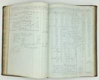
1852ref. 1338Original manuscript. 1852-1854. Folio 38 x 27cm. Full contemporary reverse calf with gilt morocco titles labels to the spine "Rough Sales Book / S & L / B". Marbling to page edges. Marbled endpapers with engraved label for "Baily Brothers Booksellers Stationers Account Book Manufacturers" London to the front pastedown. 172pp. of manuscript text in ink on red-ruled laid paper watermarked "W. King / 1850" followed by c.160pp. blank with a handful of pages torn out following the conclusion of the manuscript text section and another within the text. The majority of entries are in English with some in Spanish mostly written in the same hand. Condition is very good the binding firm with marking to the boards chipping to the head of the spine and a little wear to the extremities. The contents with a 3cm tear to the head of the first text page and two pages partially cut/torn away at the bottom are otherwise in good order. The ledger of a British sales agents operating in Panama during the mid-nineteenth century detailing the importation and sale of a wide variety European and South American goods into the country. The manuscript meticulously records the origin city/country importer ship the goods received and sold and the charges entailed for each shipment. A typical entry for example records the arrival of "gunpowder received per "Alexander" and sold on behalf of the Kames Gunpowder Company Glasgow" followed by details of the subsequent purchasers "J. D. Cordova" etc. and the charges/commissions taken by the agent including fees for landing expenses and "carriage to arsenal". Many of the entries describe large diverse cargoes combining both essential and luxury goods including: alpacas; chocolate pots; "41 cases of pickles and mustard"; lavender water; rocking chairs; a "copying machine"; cinnamon; scissors razors; bone buttons; horse brushes; compasses; gin; hatchets; bedsteads; looking glasses; children's toys; cloves; muslins; kegs of shot; cups and saucers; tobacco; machetes; claret; playing cards rat traps; "Aqua de Colonia" cologne; silk gloves; saddles; blunderbusses; padlocks; lace; pantaloons; "Jamaica rum"; almonds; vinegar; bonnets; sausages; gold frames; water closets; wash stands; champagne; mosquito nets; and much else besides. The origin ports include major European trade centres such as Liverpool and Glasgow but also include many South American ports such as Guayaquil Equador carrying beans cocoa coffee sugar and quinoa amongst other things; Buenaventura Colombia; Callao Peru carrying candlesticks coffee mills and bayonets; Lima Peru "bottled fruits" and cherry cordial; and Valparaiso Chile; as well as San Francisco and New York to the north. The importers themselves are also a mixture of British and Panamanian companies. A fascinating detailed insight into Panama's transatlantic and South American trade during the mid-nineteenth century. [Original manuscript]. hardcover
1914ref. 38258New York: Wittenberg Coal Company 1914. 8vo. 8 11/16 x 5 15/16 inches. 36pp. Early cloth backed boards original wrappers bound in. Provenance: Marinens Bibliotek old inked stamps; deaccessioned by the Garnisions Bibliotek in 2017 Among the earliest directions for sailing through the Panama Canal. The Panama Canal opened to shipping traffic on August 15 1914. This work issued as a promotional piece by an American coal company prints Wilson's July 9 1914 Executive Order number 1990 which detailed the rules and regulations for ships passing through the canal. Unrecorded in OCLC. Wittenberg Coal Company unknown books