[PAINTINGS - DENMARK].Biblio.com
3,474 results
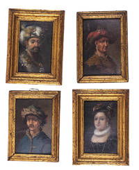
1700ref. L1ABDB3KUTB6Denmark 1700. Collection of four paintings oil on paper or paperboard two measuring 8 x 5.5 cm frame 10.5 x 7.5 cm and two measuring 8.5 x 5.5 cm frame 10 x 7 cm all with a gilt wooden frame. Two sets of two miniature paintings the individual sets painted in matching style and set in matching frames with the two slightly larger frames painted to match the two smaller ones.Ad 1: Portrait of a 16th-century woman possibly Anne of Denmark 1532-1585 wearing a red feathered cap with her hair decorated with pearls a pearl earring a small pleated ruff and a low-necked black bodice with pearls.Ad 2: Portrait of a man with a drooping moustache in oriental costume. He wears a white turban decorated with a rooster a pearl earring and a gown with a large fur collar. The collar is set with gemstones on which hang insignia's of a crescent moon with the points down above three stars.Ad 3: Portrait of a 17th-century man wearing a broad-brimmed hat with a red feather a pearl earring and a leopard fur collar.Ad 4: Portrait of a man with a thick moustache wearing a pearl earring and a blue hat and oriental coat lined with lynx fur. Provenance: Manor House in Jutland. With an inscription at the back of ad 1 "Claude George Gew Anne 1738" and wax seals on the backs of ads 1 2 and 3. Ad 4 with a 19th-century ticket "95". The top layer of ad 3 slightly damaged at the top right revealing part of the red underpainting; otherwise an interesting set in good condition. ABE CAT Costumes & Uniforms unknown
2016ref. AME_9781785369384Edward Elgar 2016. 1. Hardcover. New/New. _ Edward Elgar hardcover
2004ref. AME_9780275974985Greenwood 2004. 1st. Hardcover. New/New. _ Greenwood hardcover
1998ref. AME_9780205198566Allyn & Bacon 1998. 1st. Paperback. New/New. _ Allyn & Bacon paperback
2006ref. AME_9780521685719Cambridge University Press 2006. 1st. Paperback. New/New. _ Cambridge University Press paperback
2010ref. AME_9780313379703Greenwood 2010. 1St. Hardcover. New/New. _ Greenwood hardcover
1780ref. 200039AG1780. Paris De l'Isle et Buache 1780. Original hand-coloured engraving. Plate Size: 64.4 cm x 48.7 cm. Sheet Size: 66.6 cm x 52.7 cm. Original map. In very good condition with the slightest traces of browning only. A very detailed and interesting map of Denmark - the Jutland peninsula and the archipelago of islands such as Funen Zealand and Bornholm- and the and southern Sweden. The Duchies of Brem and Meckelbourg and Pomeranie on the German coast can be seen in the lower part of the map. The cities of Hamburg Copenhagen and Rostock are included on the map. Relief is depicted pictorially. The sand banks and shallows along the coasts are also depicted. Block of annotative French text lies within the Baltic Sea. Guillaume Delisle 1675-1726 was a renowned mapmaker who led the reform of French cartography. A brother of the astronomer Joseph-Nicolas Delisle and a student of the astronomer Jean-Dominique Cassini Delisle learned to fix accurate positions by astronomical observation. The accuracy of his continental outlines and his reduction of gross errors in determining lines of longitude were considerable improvements over earlier maps. His earliest works published in 1700 were a pair of globes terrestrial and celestial maps of the continents and a world map in hemispheres. He prepared about 100 maps and wrote on mensuration and ancient geography. At 27 Delisle was admitted into the French Académie Royale des Sciences an institution financed by the French state. After that date he signed his maps with the title of "Géographe de l'Académie". Five years later he moved to the Quai de l'Horloge in Paris a true publishing hub where his business prospered. In 1718 he was the first to become chief geographer to the king. Encylopedia Britannica unknown
1660ref. 441AG1660. Amsterdam Blaeu c.1660. Beautifully handcoloured Original Engraving copper engraving with the decorative and pictoresque Cartouches. Beautifully framed. Size of Frame with map: 66.5 cm x 80 cm. Map itself measures: 44 cm x 58 cm. Excellent condition of this beautiful original 18th century map of this area in Denmark. Framed Handcoloured ! Professionally cleaned historical map beautifully and professionally mounted/restored on see-through acid-free paper. Willem Janszoon Blaeu also abbreviated to Willem Jansz. Blaeu was a Dutch cartographer atlas maker and publisher. Blaeu was born at Uitgeest or Alkmaar. As the son of a well-to-do herring salesman he was destined to succeed his father in the trade but his interests lay more in Mathematics and Astronomy. Between 1594 and 1596 as a student of the Danish astronomer Tycho Brahe he qualified as an instrument and globe maker. In 1600 he discovered the second ever variable star now known as P Cygni. Once he returned to Holland he made country maps and world globes and as he possessed his own printing works he was able to regularly produce country maps in an atlas format some of which appeared in the Atlas Novus published in 1635. In 1633 he was appointed map-maker of the East Indian Company. He was also an editor and published works of Willebrord Snell Descartes Adriaan Metius Roemer Visscher Gerhard Johann Vossius Barlaeus Hugo Grotius Vondel and the historian and poet Pieter Corneliszoon Hooft. He died in Amsterdam. He had two sons Johannes and Cornelis Blaeu who continued their father's mapmaking and publishing business after his death in 1638. Prints of the family's works are still sold today. Original maps are rare collector items. The Dutch painter Johannes Vermeer of Delft 1632-1675 holds a position of great honor among map historians. Several of his paintings illustrate maps hanging on walls or globes standing on tables or cabinets. Vermeer painted these cartographical documents with such detail that it is often possible to identify the actual maps. Evidently Vermeer was particularly attached to a Willem Blaeu - Balthasar Florisz van Berckenrode map of Holland and West Friesland as he represented it as a wall decoration in three of his paintings. Though no longer extant the map's existence is known from archival sources and second edition published by Willem Blaeu in 1621 titled "Nova et Accurata Totius Hollandiae Westfriesiaeq. Topographia Descriptore Balthazaro Florentio a Berkenrode Batavo". Vermeer must have had a copy at his disposal or the earlier one published by Van Berckenrode. Around 1658 he showed it as a wall decoration in his painting "Officer and Laughing Girl" which depicts a soldier in a large hat sitting with his back to viewer talking with a smiling girl who holds a glass in her hand. Bright sunlight bathes the girl and the large map on the wall. Vermeer's gift for realism is evidenced by the fact that the wall map mounted on linen and wooden rods is identifiable as Blaeu's 1621 map of Holland and West Friesland. He captures all of its characteristic design decoration and geographic content." His maps formed the bulk of the Atlas Maior that became a collector's item in Amsterdam. One of Blaeu's globes was purchased at auction by Maarten Magielse a Dutch salesman for the record price of 60.000 euro about $80.000. Magielse is now renting it to the globe museum in Vienna where it is being exhibited. Wikipedia unknown
ref. 73069ABHorsens Danish Town Planning Laboratory No Date. 13 cm x 21 cm. 85 Pages. Original Softcover. Very good condition with only very minor signs of external wear. Includes for example the following essays: Introduction / The Country / The Region / The Municipality / Centre Areas / Industrial Areas / Residential Areas / Recreational Areas / etc. paperback
1846ref. 3170761846. 1 page. 4to. Old folds some chipping. 1 page. 4to. unknown
1789ref. 56256Hamburg 1789. With four folding charts in vol. I. Pp.2 xxx 14 contents 578; xii 2 contents 556. 2 vols. 8vo. Contemporary quarter calf and boards. Rubbed. About very good. With four folding charts in vol. I. Pp.2 xxx 14 contents 578; xii 2 contents 556. 2 vols. 8vo. First and only edition of this important documentary source publishing letters and papers of Frederick IV of Denmark Queen Anna Sophia of Dänemark correspondence with the King of Prussia as well as texts concerning Copenhagen the judiciary police and city council changes in the Danish language etc. A further continuation volume appeared in 1790. unknown
1650ref. 51209Frederick de Wit 1650. Contemporary Coloring. With Wonderful Cartouche Upper Right. 1 vols. 23 x 20 inches. About Fine. Framed and glazed. Contemporary Coloring. With Wonderful Cartouche Upper Right. 1 vols. 23 x 20 inches. Frederick de Wit unknown
ref. ria9781119611219_inpPaperback / softback. New. New Book; Fast Shipping from UK; Not signed; Not First Edition; N/A paperback
ref. 8778381851.Ghardcover. Good. Access codes and supplements are not guaranteed with used items. May be an ex-library book. hardcover
1952ref. 34931New York: Hispanic Institute 1952. First Edition. Original Wraps. Very Good. Quarto. 252pp A very good copy in tan printed wraps. Inscribed By Author Hispanic Institute paperback
ref. 54159993-nnew. unknown
ref. 25681114-nnew. unknown
ref. 53767719like new. unknown
ref. 5597127like new. unknown
ref. 25809303like new. unknown
ref. 27914764like new. unknown
ref. 6127059748Oxford University Press OUP . Papeback. New. pp. 512 Index 4th edition Oxford University Press OUP unknown
ref. 25809301like new. unknown
ref. 27914791like new. unknown
ref. ria9781803272153_inpPaperback / softback. New. New Book; Fast Shipping from UK; Not signed; Not First Edition; Nineveh Iraq is one of the longest occupied cities in the world dating at least back to the mid-7th millennium BC. UC Berkeley excavations uncovered a district of large dwellings and wide streets near the Maški Gate MG22 providin paperback