HAGMANN, J(ohann) J(akob) jr.:Livre Rare Book

47 283 résultats
réf. 140045aafLichtensteig, Verlag des Herausgebers, 1877, in-8vo, (16,7x11.4 cm), XVI (Titelblatt - Vorwort ‘ - Inhalts-Verz. - Ill. Verz. - Quellenlitteratur über das Toggenburg - Vocabularium) + 292 S. + 12 gelbe S. mit Werbung (2 Abb. v. Gasthof zur Krone, Lichtensteig & Gasthof zur Krone, Ebnat) + 1 gef. Karte + 15 Tafeln + 1 Panorama, fleckig.
réf. 88714aafParis, Chez Audin et Urbain Canel, 1824, in-8vo, titre + 358 p. + 5 planches h.-t. ; titre + 360 p. + 3 pl. h.-t. Au total 8 planches (dont le frontispice ‘Chaumière Suisse’), cartonnages de l’éditeur d’époque usés, dos avec pièce de titre et de tomaison (manque une pièce de tomaison du T.1), charnière en bas du T. 2 fendue.
réf. Caragh Rockwood and RebecIn Pristine Condition. unknown
182817 cm, ril. mezza pelle, fregi in oro e titolo su tassello al dorso, piatti marmorizzati, p. (1)VIII, 131, 2 carte geografiche ripiegate. Antiporta inciso in rame "königliches schauspielhaus" ed una tavoa fuori testo "Museum". La prima grande carta geografca (27x24 cm) con veduta della città di Berlino su disegno del cartografo prussiano Carl Ludwig von Oesfeld incisa ed aggiornata nel 1827. La seconda tavola ripiegata (15x16 cm) carta geografica dei dintoni della capitale entro cornice rotonda, incisa e firmata da Carl Jattnig. Pagine diffusamente ingiallite (qualità della carta) esemplare complessivamente molto buono. Edizione assai rara.
182620 cm, ril. coeva in mezza pelle a quattro nervi con fregi e titolo in oro su tassello, piatti marmorizzati, p. XXIX, 280, XIV tavole calcografiche finemente incise su rame, alcune più volte ripiegate come la pianta di Bologna e della chiesa di San Petronio. Forellino di tarlo a 2 carte. Leggero alone alle prime 8 carte, restauro professionale alla Tav. IX. Per il resto esemplare ben conservato, in barbe e completo di tutte le illustrazioni.
Tipografia Luigi Pezzati, Firenze, 1826. In 8vo, doppio front. e testo italiano / francese a fronte, pp. XLV, 297 (con Indice), alcune antiche iscrizioni riportate nel testo, completo delle 20 vedute f. t. incise all'acquatinta e delle 6 tavole rip. f. t. (di cui alcune ancora all'acquatinta), contropiatti e fogli di guardia in carta celestina, leg. orig. con dorso in pelle, titoli e fregi in oro, piatti in cartone marmorizz. con piccole punte in pergamena. Bell'esemplare in solida ed elegante legatura, ottime le belle incisioni. .
Ferrara, Abramo Servadio Editeur, 1850. In folio, antip. incisa in acciaio (“Porta di Schifanoja”), front. con piccola vignetta incisa, pp. 175 + 4 di Indici, titolo entro elaborata cornice tipografica e testo entro cornice. Molte tavv. litografiche in b/ n. raffiguranti monumenti e luoghi di interesse della città (sono presenti le tavole del castello, della cattedrale, del cimitero (in tonolitografia incisa dal Doyen) e dell'Università di Ferrara; le tavole rappresentanti Borso e Leonello D’Este sono finemente colorate a mano, in bella coloritura coeva; sciolte quelle degli altri signori della città, insieme a quelle del Tasso e dell'Ariosto. Leg. orig. in tela grigia con titoli oro al piatto (“Ricordo di Ferrara che L. A. T. offre ad Anna Hersche il 1 maggio1861”), filettatura a secco ai piatti, contropiatti e fogli di guardia in carta rosa lavorata. Importante compilazione testuale arricchita dalle tavole. Segni e sciupature alla legatura, esemplare uniformemente ingiallito con sporadico foxing ad alcune pagine, le tavole sciolte pur un poco rifilate sono ancora in ampi margini.
réf. 6972Paris, London, Hachette & Company, 1912. 1 volume in-12, 12 pp. + XXVII pp. + 471 pp. + 8 pp. (annonces publicitaires), enrichi de 43 cartes et plans, souvent dépliants, reliure toile rouge éditeur, très bon état général.
18382 vol. in-12, pp. complessive 728 (2), Legatura edit. cart. con bordura silogr. E titolo sui piatti. Importante l'Avvertimento al Lettore (pp. 5-8) con la storia delle edizioni dell'opera, già inserito nella guida del 1830. Con 2 piante ripieg. di Roma antica e moderna e complessive 40 tavole di vedute e piante inc. in rame all'acquatinta. Grazioso esempl. Di importante guida di Roma.. Non in Schudt. Rossetti G-1611. Comune Roma, Le guide antiche, n. 132. Caldana, Le guide di Roma, p. 236..
Vincenzo Bonfigli, Livorno, 1682. In 8vo grande, front. con stemma mediceo a sei palle, pp. (30), 508, leg. orig. in tutta perg. rigida, titolo ms. al dorso. Edizione originale di quest’opera che può essere a merito considerata una delle più vaste fonti di notizie per la storia di Pisa. (Cfr. Lozzi pag. 3684: “Bello e raro”; Piantanida, pp. 933: “non ci sono note altre edizioni di quest’importante opera postuma divenuta oggi molto rara”; Romagnoli: “assai raro”). Pergamena per lo più scurita e con difetti, tagli normalmente scuriti, pagine leggermente ingiallite e ondulate, nell'insieme trattasi comunque di un buon esemplare.
1989réf. BN313085Hachette Tourisme 1989. 1989. Softcover. Arles et la Camargue Arles et la Camargue Guide Bleu Hachette Tourisme paperback
2001réf. BN6722292001. 2001. Hardcover. Les Couleurs des Châteaux de la Loire Les Couleurs des Châteaux de la Loire Guide Pélican hardcover
2004réf. BN554537Nouvelles éditions de l'université - Le Petit Futé 2004. 2004. Softcover. Carcassone 2004 Carcassone 2004 Guide Petit Futé Nouvelles éditions de l'université - Le Petit Futé paperback
2002réf. BN671838Nouvelles éditions de l'université - Le Petit Futé 2002. 2002. Softcover. Côte d'Azur - Monaco Côte d'Azur - Monaco Guide Petit Futé Nouvelles éditions de l'université - Le Petit Futé paperback
2002réf. BN705470Glénat 2002. 2002. Softcover. Essonne Essonne Guides Franck Glénat paperback
The very rare first edition of this comprehensive guide to Lyon, with extensive historical notes on the streets, churches, and other landmarks, as well as capsule biographies of notable sons of the city. xvi, 283, [3] pp. Beautifully printed on fine laid paper. 8vo. Bound in contemporary half sheep and boards. Decorated spine. All edges flecked in blue. An excellent copy, with no wear to the binding. Internally clean and bright. Barbier I, 896.
1880in-8 gr., pp. (2), 1000, solida legatura del tempo m. vitello, titolo e fregi oro al dorso. Non comune vasta opera sulla città di Torino e suoi dintorni, descritti sotto vari aspetti. Raccoglie 26 varie ed interessanti monografie sulla vita culturale, storica, artistica, sociale ed industriale della città nell'800, scritte da 26 insigni piemontesi. L'ultima parte si occupa dei dintorni: la collina, Moncalieri, Superga, Rivoli, Sagra di S. Michele, Stupinigi. Edizione originale. Ottimo e fresco esemplare, non comune.. Fossati Bellani 1812..
réf. BN104769Guides de voyage Ulysse. Softcover. Chili Chili Guides de voyage Ulysse paperback
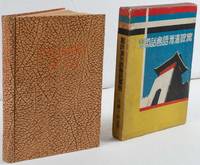
1935réf. 220033大阪. Osaka.: 巧人社. Kōjinsha. Showa 10 1935. 18 x 13cm 169pp hardback pictorial endpapers occasional spotting title page browned a very good copy in original pictorial slipcase. This book was published in 1935 three years after Manchukuo was founded. After a short introduction the book explains numbers pronouns and grammar before teaching Manchu conversations on various topics including weather time and travelling. The target readers would have been those visiting Manchuria on business or as tourists. Thus conversations are set in the context of shopping and travelling. Pronunciations of Manchu are written in the Latin alphabet and katakana. Humorous illustrations appear on the endpapers while the slipcase has been decorated in the distinctive colours of the Manchukuo flag with an illustration of a city gate. . 巧人社. [Kōjinsha]. hardcover
réf. Proctor, James & Neil RolIn Pristine Condition. unknown
1910réf. 2080202105101330Watanabe shoten 1910. Soft Cover. Fine. Volume: 1 Watanabe shoten paperback
1930Very Good Turkish, Ottoman (1500-1928) Original pictorial wrappers. Chromo-lithographed photo-montage collage cover with seven b/w photos of African buildings and natives, and a red map of Africa. Complete in wrappers and folded huge Africa map (size: 57 x 82 cm). Cover size: 28.5 x 20.5 cm. In Turkish. Scale: 1/20,000,000. A very rare chromo-lithographed Africa map, prepared for the geography lessons about foreign countries in Turkey in 1930. The map shows the territories of the African continent, which was still politically under European colonialism as of the 1930s. It includes Rio de Oro (Spanish territory), Fas [i.e. Morocco], Algeria, Sahara, Cameroon (French territories), Trabulus [i.e. Libya] as Italian territory; and Liberia, Egypt, East Sudan, Eritre [i.e. Eritrea], Habesistan [i.e. Ethiopia], Somali, Kenya, Belgian Kongo, Angola, Mozambique and South African land including Rhodesia (equivalent in the territory to modern Zimbabwe), Transvaal, The Orange Free State [Oranje-Vrystaat], Natal and Kap [Cape] with Madagascar. An extra panel for the same scale map showing the Suez Canal, Nile Delta, and North Egypt in the lower-left corner. Duran studied in Istanbul and Paris. He worked as a geography teacher in various high schools and afterward he undertook the positions of lecturer and administrator in Ankara Gazi Education Institute for a time. He was known for his writings on various topics and particularly for his works on geography. Born in the imperial period, Duran conducted the first cartographic studies of the Republic of Turkey after the transition to the Republican administration. Sealed. Slight foxing. Otherwise a fine copy. Not in OCLC.
1800Very Good French Original decorated map. Hand-coloured. Oblong elephant folio. (54 x 76 cm). In French. Shows Greece, Archipelago, Isle de Candie, Asia Minor (Western side), and East Mediterranean. Delisle od de l'Isle was a French cartographer known for his popular and accurate maps of Europe and the newly explored Americas. At 27, Delisle was admitted into the French Académie Royale des Sciences, an institution financed by the French state. After that date, he signed his maps with the title of "Géographe de l'Académie". Five years later, he moved to the Quai de l'Horloge in Paris, a true publishing hub where his business prospered. Delisle's progress culminated in 1718 when he received the title of Premier Géographe du Roi. He was appointed to teach geography to the Dauphin, King Louis XIV's son, a task for which he received a salary. Again, his father's reputation as a man of science probably helped the younger Delisle. Historian Mary Sponberg Pedley says, 'once authority was established, a geographer's name might retain enough value to support two or three generations of mapmakers'. Delisle's case, it could be said that his accomplishments surpassed his father's. Up to that point, he had drawn maps not only of European countries, such as Italy, Spain, Germany, Great Britain, Poland, and regions such as the Duchy of Burgundy, but he had also contributed to the empire's claims to recently explored continents of Africa and the Americas. Like many cartographers of his day, Delisle did not travel with the explorers. He drew maps mostly in his office, relying on a variety of data. The quality of his maps depended on a solid network to provide him first-hand information. Given his family's and his own reputation, Delisle had access to fairly recent accounts of travellers who were returning from the New World, which gave him an advantage over his competitors. Being a member of the Académie, he also kept current with recent discoveries, especially in astronomy and measurement. When he could not confirm the accuracy of a source, he would indicate it clearly on his maps. For instance, his Carte de la Louisiane shows a river that the baron of Lahontan claimed he discovered. As no one else could validate it, Delisle noted a warning to the viewer that it might not exist. (Source: Wikipedia). Tooley, p.43.
1909Very Good Turkish, Ottoman (1500-1928) Original color map on cloth. A little foxing on cloth. Very good. Folded. Oblong atlas folio. (66 x 72 cm). In Ottoman script. Scale: 1/210.000. Ottoman sanjaks in Albania and Greece. A rare Ottoman map of Balkans with Turkish place names for the period of pre-Balkan Wars, (1912-1913). Very important for onomastics and historical geography. Written 'Paris -French meridian- was accepted as the 0 meridian'. The Paris meridian is a meridian line running through the Paris Observatory in Paris, France-now longitude 2°20'14.03" east. It was a long-standing rival to the Greenwich meridian as the prime meridian of the world. Personal stamp of Muhiddin Pasha on cloth, under the printed descriptive texts. It's from the collection of him. Hasan Muhiddin Pasha [Çanga], (1866-1944), who was a lieutenant in Hedjaz Army of the Ottoman Empire in 1887. After he suppressed the rebellion in Yemen, 1891, his rank was promoted to the 'major'. After the Imam Yahya rebellion in Yemen, 1904, he prepared a report for the Ottoman government. He also took part in Ethiopia, Sudan, Yemen, Arabian Peninsula for various military duties. After promotion to division command, he was provincial president of CHP (Republican People's Party). He was a very important politic and diplomatic figure for the last period of Ottoman and early Republican Turkey. Not in Tooley. Extremely rare.
1909Very Good Turkish, Ottoman (1500-1928) Original color map on cloth. A little foxing on cloth. Very good. Folded. Oblong atlas folio. (66 x 72 cm). In Ottoman script. Scale: 1/210.000. Ottoman cities in Bulgaria. A rare Ottoman map of Balkans with Turkish place names for the period of pre-Balkan Wars, (1912-1913). Very important for onomastics and historical geography. Written 'Paris -French meridian- was accepted as the 0 meridian'. The Paris meridian is a meridian line running through the Paris Observatory in Paris, France-now longitude 2°20'14.03" east. It was a long-standing rival to the Greenwich meridian as the prime meridian of the world. Personal stamp of Muhiddin Pasha on cloth, under the printed descriptive texts. It's from the collection of him. Hasan Muhiddin Pasha [Çanga], (1866-1944), who was a lieutenant in Hedjaz Army of the Ottoman Empire in 1887. After he suppressed the rebellion in Yemen, 1891, his rank was promoted to the 'major'. After the Imam Yahya rebellion in Yemen, 1904, he prepared a report for the Ottoman government. He also took part in Ethiopia, Sudan, Yemen, Arabian Peninsula for various military duties. After promotion to division command, he was provincial president of CHP (Republican People's Party). He was a very important politic and diplomatic figure for the last period of Ottoman and early Republican Turkey. Not in Tooley. Extremely rare.