Elan GuidesBiblio.com

47 027 résultats
réf. Z1-B-028-00908Wiley. Used - Like New. Used - Like New. This is a brand new book! Ships from UK in 48 hours or less usually same day. Your purchase helps support Sri Lankan Children's Charity 'The Rainbow Centre'. 100% money back guarantee. We are a world class secondhand bookstore based in Hertfordshire United Kingdom and specialize in high quality textbooks across an enormous variety of subjects. We aim to provide a vast range of textbooks rare and collectible books at a great price. Our donations to The Rainbow Centre have helped provide an education and a safe haven to hundreds of children who live in appalling conditions. We provide a 100% money back guarantee and are dedicated to providing our customers with the highest standards of service in the bookselling industry. Wiley unknown
réf. Z1-C-031-00865Bibliolife. Used - Like New. Used - Like New. Book is new and unread but may have minor shelf wear. Ships from UK in 48 hours or less usually same day. Your purchase helps support Sri Lankan Children's Charity 'The Rainbow Centre'. 100% money back guarantee. We are a world class secondhand bookstore based in Hertfordshire United Kingdom and specialize in high quality textbooks across an enormous variety of subjects. We aim to provide a vast range of textbooks rare and collectible books at a great price. Our donations to The Rainbow Centre have helped provide an education and a safe haven to hundreds of children who live in appalling conditions. We provide a 100% money back guarantee and are dedicated to providing our customers with the highest standards of service in the bookselling industry. Bibliolife unknown
1996réf. 11567Gordonsville Virginia U.S.A.: St Martins Pr/ Thomas Dunne Press. New. Paperback. FREE UPGRADE to Courier/Priority Shipping Upon Request - IN STOCK AND IMMEDIATELY AVAILABLE FOR SHIPMENT - AVOID WEEKS OF DELAY ELSEWHERE. -- with no writing or markings to the text. -- with a bonus offer--; 011567; EUROPE GUIDEBOOKS TRAVEL . 1996. 031214234X . St Martins Pr/ Thomas Dunne Press paperback
réf. Z1-Q-015-03485Get Through Guides. Used - Good. Ships from UK in 48 hours or less usually same day. Your purchase helps support Sri Lankan Children's Charity 'The Rainbow Centre'. Ex-library so some stamps and wear but in good overall condition. 100% money back guarantee. We are a world class secondhand bookstore based in Hertfordshire United Kingdom and specialize in high quality textbooks across an enormous variety of subjects. We aim to provide a vast range of textbooks rare and collectible books at a great price. Our donations to The Rainbow Centre have helped provide an education and a safe haven to hundreds of children who live in appalling conditions. We provide a 100% money back guarantee and are dedicated to providing our customers with the highest standards of service in the bookselling industry. Get Through Guides unknown
réf. Z1-Q-015-03484Get Through Guides. Used - Good. Ships from UK in 48 hours or less usually same day. Your purchase helps support Sri Lankan Children's Charity 'The Rainbow Centre'. Ex-library so some stamps and wear but in good overall condition. 100% money back guarantee. We are a world class secondhand bookstore based in Hertfordshire United Kingdom and specialize in high quality textbooks across an enormous variety of subjects. We aim to provide a vast range of textbooks rare and collectible books at a great price. Our donations to The Rainbow Centre have helped provide an education and a safe haven to hundreds of children who live in appalling conditions. We provide a 100% money back guarantee and are dedicated to providing our customers with the highest standards of service in the bookselling industry. Get Through Guides unknown
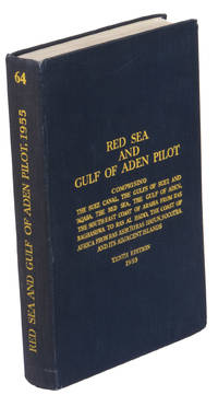
1955réf. ABC_47446London 1955. 8vo. Published for the Hydrographic Department Admiralty Original blue cloth with yellow lettering on the spine and the front board the supplement is loosely inserted at the end of the volume: original printed paper wrappers stapled. With a folding map printed on both sides 2 coloured plates with diagrams printed on both sides 28 plates showing coastlines and occasionally a map many printed on both sides and many some illustrations in text. 2 LI = LIII: II plus 1 1 blank 1 blank 518 1 1 blank pp; Supplement: 20 pp. The essential standard sailing directions for the Red Sea and Gulf of Aden corresponding with zone NP64 on the official Admiralty charts. These nautical works - pilot guides and charts - were published by the United Kingdom Hydrographic Office which provides the necessary hydrographic and marine geospatial data to all kinds of maritime organisations across the world. The publications are not only used by the British Royal Navy but can also be found on board the majority of international merchant ships. The data provided in the pilot guides and other publications are compliant with SOLAS the Safety of Life at Sea treaty guidelines and are updated constantly in weekly "Notices to mariners" and supplements to and new editions of the pilot guides whenever necessary.The present copy is the 10th edition 1955 of the pilot guide with sailing directions and other information on the weather currents radar ranges etc. relating to the Red Sea and Gulf of Aden including the supplement issued in 1957. It includes an erroneous "advertisement to the eight edition" by the Hydrographer of the Navy Rear-Admiral Kenneth St Barbe Collins 1904-1982. The advertisement states that with the publication of "the ninth edition" presumably this volume the previous edition and its supplements are cancelled since the most up-to-date information has been compiled in the new edition and the weekly "Notices to mariners" that appeared after the publication of the 11th edition. The 10th edition of 1955 and its 1957 supplement were made redundant with the publication of the 11th edition in 1967. Each subsequent edition of the pilot supersedes the last which have appeared infrequently depending on newly available information from the mid-19th century until the present day.The front paste-down and recto of the first free endpaper contain a "caution" notice and room for the notation of "supplements and annual summaries of notices to mariners relating to this book" the first two pages are printed on red-pink paper. The binding shows minor signs of wear around the spine and corners of the boards the gutter after page II is somewhat weakened the head edge of the wrappers of the supplement are very slightly browned. Otherwise in very good condition. hardcover
1824réf. LCPCVOY-0033(Un excéptionnel guide de Moscou en édition originale. Un séduisant exemplaire tel que paru, à toutes marges, non rogné et en très grande partie non coupé) LE COINTE DE LAVEAU Georges. "GUIDE DU VOYAGEUR A MOSCOU, CONTENANT CE QUE CETTE CAPITALE OFFRE DE CURIEUX ET D'INTERESSANT... ET SUIVI D'UN ITINERAIRE DES PRINCIPALES ROUTES DE LA RUSSIE". 1824, Moscou, A. Semen. 1 volume in-8° (238x144 mm) (dimensions pages 238x153 mm) (2) ff. (faux-titre et titre), 1 frontispice gravé, (1) f. (dédicace), VI pp. (avertissement), pp. 11 à 459 (y compris la table des chapitres et des matières), (1) p. (errata), 6 tableaux dépliants et 5 in texto, 7 planches lithographiées h.t. ((2) ff., (7) ff., 2-12(8), (1) f. ajouté au f. 12(8), 13-26(8), 27-29(4), 30(8), (1) f.) Brochure beige imprimée originale. Exemplaire conservé dans une boîte de plexiglass. Edition Originale, très rare, du premier guide de Moscou. Quelques déchirures et un petit manque de papier dans la partie supériure du dos. Quelques petites brunissures éparses au début et en fin de l'ouvrage. Légères traces de poussière dans les marges extérieures. Mais superbe exemplaire tel que paru, à toutes marges, non rogné et avec de nombreux cahiers non coupés. Conservé dans sa brochure beige imprimée originale. Très curieuse guide de Moscou, avec la description de son histoire, de ses monuments et de ses institutions civiles et politiques. L'auteur précise que "malgré les relations nombreuses que Moscou entretient avec tous les états d'Europe... cette ville qui se trouve maintenant sur une multitude d'itinéraires, n'est cependant pas encore connue sous ses véritables rapports. Des erreurs qui ont été répétées par des voyageurs qui la visitèrent dans les premiers tems de son origine, se sont perpetuées jusquìà nos jours ; et il n'est pas rare de trouver à son sujet, dans les géographes, de fausses notions encore empreintes de la grossièreté des siècles dans lesquels elles ont été puisées". Nombreuses sont les pages dédiées aux collections particulières d'oeuvres d'art, de peinture et de livres précieux. Une Bible de Gutemberg, par exemple, est mentionnée dans les collections du Prince Michel Pétrovich Gallitzin. Le dernier chapitre du livre s'occupe des postes et des diligences et offre des tableaux avec tous les itinéraires et les correspondances de Moscou vers les principales villes de la Russie et vers les frontières du pays. L'auteur offre des conseils aux voyageurs en précisant que la diligence "n'attend pas le voyageur qui tarde, et qui perd sa place s'il ne parvient pas à rejoindre à la première poste..." et que le bagage "doit être de nature à se laisser facilement emballer et ne doit pas être d'un poids au dessus de 20 livres...". (LCPCVOY-0033) (1.700,00 €)
1556réf. 42049In Venetia, Appresso Giordano Ziletti, all'insegna della Stella, 1556. Petit in-8 (15 x 10 cm) de (24)-316 pp., (signatures * * A-V7 - le dernier blanc) vélin souple, titre en capitales manuscrit sur le dos (reliure de l'époque).
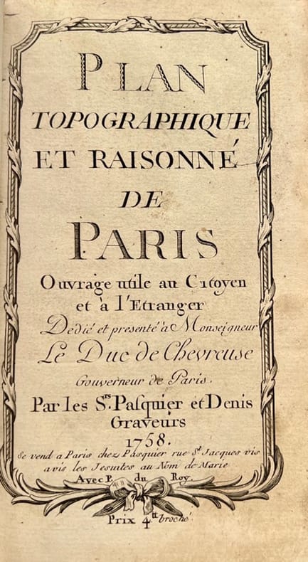
1758réf. 42372Se vend à Paris, chez Pasquier et Denis, 1758. Petit in-8 de 3 ff.n.ch., 149 pp., 1 f.n.ch., veau lisse brun, dos orné, pièce de titre en maroquin rouge (reliure de l'époque).
réf. 2091502135500419Not Available N.A. Soft Cover. Fine. The book is in fine condition. Not Available paperback
1909Very Good Turkish, Ottoman (1500-1928) Extremely rare huge chromo-lithograph map in 24 sheets mounted on canvas, showing a large zone including Midyat (Mardin), Mosul, Mt. Cilo (Resko-Buzul) on the southeast; Kahta (Adiyaman), Munzur Mt., Divrigi (Sivas) on the west; the Black Sea on north and Turkish borders to Armenia, Azerbaijan on the east, and to Russia on the northeast. In addition shows in separate little portions, roads, mountains and hills, lakes, and telegraph and post ways and borders in that zone. Not in any libraries and any collection. An attractive map with its huge size and decorative surface. Several toponyms are underlined in red ink. Otherwise a very good example. Original folded map mounted on canvas. 118x112 cm. In Ottoman script (Turkish with Arabic letters). Scale: 1/630.000.
1942Very Good Turkish Paperback. A manuscript notebook. Roy. 8vo. (23 x 16 cm). In Turkish (Modern). 145, [10] p., schemes. Toprak hukuku, 1942-1943. These extremely rare and unpublished manuscript notes on 'land law' or 'real property law', were taken by a student between the years of 1942-44 during Mardin's lessons in Istanbul University. Very legible script. Fine manuscript with extra papers inside. Mardin was a Turkish jurist, academician and politician. He was one of the ends of the Ottoman Empire and the firsts of Turkish Republic lawyers. He worked as a lecturer at Istanbul University during his whole life, where he graduated, and became a professor of the Civil Law. He ws born in Shkodra. Extremely rare.
Audot, 1830 circa (senza altre indicazioni tipografiche). Due volumi in 8vo oblungo composti di sole tavole, incise dai più valenti intagliatori di vedutismo dell'epoca, tra questi l' Audot, i fratelli Rouargue, l'Aubert e il Durau. Il vol. I contiene circa 116 vedute (Milano, Como, Pavia, Brescia Cremona, Verona, Venezia, Parma, Genova, Bologna, Livorno, Pisa, Capri, Taranto, Messina, Catania, Palermo e loro contorni, con alcune scene di costumi e tradizioni; ci sono vedute anche di altre città); il vol. 2 contiene circa 116 vedute (Roma e Napoli e loro contorni, con alcune scene di costumi e tradizioni). La numerazione di entrambi i volumi è discontinua ma si tratta in totale di circa 232 tavole. Legature con piatti in cartonato telato e dorso con titoli e nervi oro, contropiatti e fogli di guardia in carta marmorizz. marrone. Normali segni alla legatura, buone le tavole.
1820réf. 54235London, Tayler and Hessey, 1820. origi.Pappband, 4°, 101 Seiten. Particulary those that are useful for finding the longitude and latitude at sea. With twelve planishpheres.
1860(4), 340pp., (2)ff Broché, couverture originale imprimée 1860, 1860, in-16, (4), 340pp, (2)ff, Broché, couverture originale imprimée, TRÈS RARE EXEMPLAIRE ENTIÈREMENT ILLUSTRÉ DE TIRAGES PHOTOGRAPHIQUES D'ÉPOQUE : 18 petites photographies d'époque sur papier salé, le tout monté dans le texte (dont une en guise de publicité pour l'artiste, représentant son atelier du Pavillon vert). PREMIÈRE ÉDITION de ce guide de Joseph Morlent, auteur de nombreux ouvrages sur la Seine-Maritime. L'illustration, d'habitude gravée sur bois dans le texte, est ici remplacée par des petites photographies tirées sur papier salé par Kaiser, un photographe havrais dont l'atelier, le Pavillon Vert se situait rue Jeanne-Hachette. Rousseurs et piqûres au texte et sur la couverture. Manque à Frère
Livorno, presso Giovanni Marenigh, 1812, voll. 3 in-8, br. edit. con fregi tipografici, pp. XXIV, 507, [3] (con 8 tavv. f.t.) - XXIII, [1], 560, [2] (con 17 tavv. f.t.) - [2], XVI, 589, [3] (con 8 tavv. f.t.). Complessivamente il corredo iconografico è formato da 33 tavole calcografiche (36 nel caso si consideri la tavv. n. 7 del primo volume, recante 4 rami, come 4 tavole), spesso ripiegate f.t., fra cui un ritratto, una pianta della città, alcune vedute, monumenti e opere d'arte. Seconda edizione, corretta e notevolmente ampliata di questa eccellente opera che espone per la prima volta la storia dell'arte pisana complessivamente. Particolare pregio è conferito ai volumi da due incisioni del ‘400 delle quali il Da Morrona possedeva i rami originali e di cui non si conoscono tirature precedenti e che vengono attribuite a Baccio Baldini e a Maso Finiguerra. Moreni, I, 101. Esemplare in ottimo stato di conservazione, ancora con la sua brossura editoriale e a pieni margini: la copertina anteriore del primo volume è un poco brunita ed è presente qualche piccolissima mancanza marginale e ai dorsi.
1869réf. 2111902160200041Mr. Hayashi's woodblock copy 1869. Soft Cover. Fine. Number of pages: 186 pages Size: 13.5cmx18.3cm Number of books: 1 Mr. Hayashi's woodblock copy paperback
1788A Genes 1788 chez Yves Gravier libraires sous la Loge de Banqui. (mm. 175 x 110). Bella legatura coeva in pelle maculata con fregi e titolo, entro tassello, al dorso; tagli rossi. Frontespizio, pp. 268. Con una grande pianta di Genova più volte ripiegata, una “ Vue de Genes “ su carta azzurrina e un “ Plan de la ville de Genes “ anch’esse ripiegate, tre di costumi, il sacro catino, il rostro e undici vedute della città ripiegate. Bell’esemplare completo delle 19 incisioni in rame.
180020 cm, in 8°, rilegatura coeva in cartone alla rustica, taglispruzzati in rosso, p. VII, 71 (1) con 25 carte geografiche più volte ripiegate e graziosamente incise su rame, con gli itinerari che collegano le principali città e le tappe intermedie dei viaggi postali. Le tavole sono arricchite del dettaglio dei fiumi e dei promontori che si incontrano nei vari percorsi. Doppio frontespizio bilingue e testo su due colonne in italiano e francese. La parte finale del volume descrive i regolamenti e le tasse di pedaggio per valicare il confine tra Francia ed Italia attraverso il passaggio del Moncenisio in Piemonte. Ottimo lo stato di conservazione generale del testo e delle tavole ad eccezione del solo itinerario "da Milano a Venezia" che presenta minimi segni di consultazione. Al frontespizio (francese) due piccole note di possesso coeve.
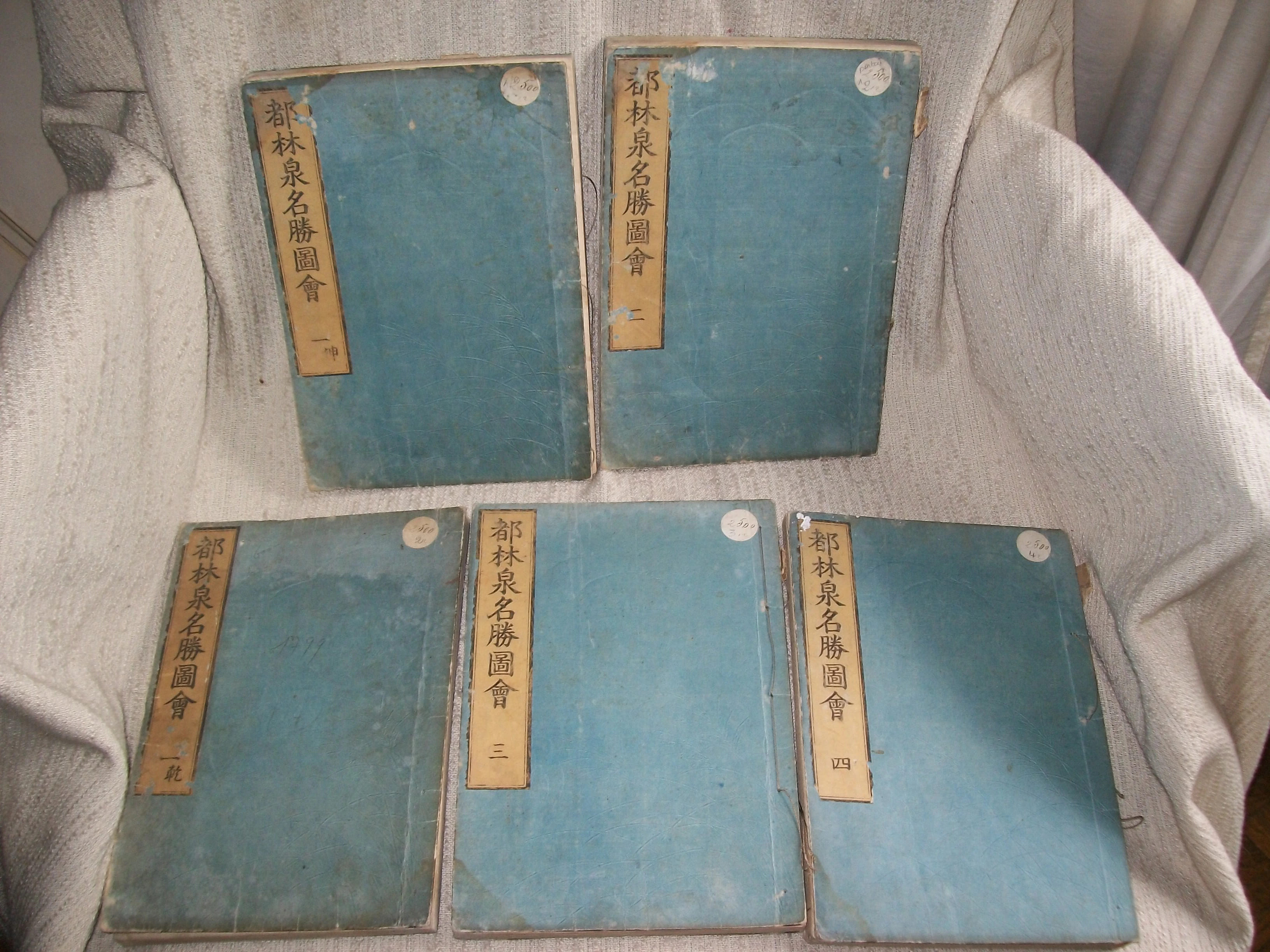
1799réf. GITk824(Kyoto 1799). 5 volumes sur 6 (26,5cm sur 18,5cm) imprimés sur beau papier de mûrier selon la technique traditionnelle du fukurotoji (pages doublées et cousues au moyen de ligatures), plats de couverture cartonnée bleue avec le titre imprimé en noir sur fond ocre, appliqué sur le 1er. *TOME I 1re partie: 37 feuillets non chiffrés soit 74pp *TOME I 2e partie: 58 feuillets non chiffrés soit 116pp *TOME II: 38 feuillets non chiffrés soit 76pp *TOME III: 40 feuillets non chiffrés soit 80pp *TOME IV: 54 feuillets non chiffrés soit 108pp. SANS LE TOME V ET DERNIER. Orné de 139 magnifiques gravures sur bois bien nettes et d'une grande fraîcheur (24 à pleine page et 115 sur double page) représentant principalement des vues de jardins de temples, monastères, pavillons de thé. La plupart offrant un foisonnement de personnages de tous âges, sexe et condition sociale. Sutures décousues; petits manques sur les étiquettes de titre; auréole claire ancienne en tête des feuillets des deux parties du Tome I et au bas des fonds des Tomes II, III, IV; petite galerie de vers marginale sans gravité sur 7 feuillets du Tome I 2e partie et 5 feuillets du Tome II, plus importante dans les fonds du Tomme III sans dommage pour le texte et les gravures. BEL EXEMPLAIRE MALGRE LES DEFAUTS SIGNALES l'impression du texte (en japonais et en chinois), ainsi que celle des gravures étant fraîche et bien nette.
1846(8), XXIV, 309pp., 1 carte et 8 plans cartonnage d'éditeur jaune imprimé en noir, dos lisse orné (cartonnage à la cathédrale, dit Biedermeier) 1846 ;, 1846 ;, in-16, (8), XXIV, 309pp, 1 carte et 8 plans, cartonnage d'éditeur jaune imprimé en noir, dos lisse orné (cartonnage à la cathédrale, dit Biedermeier), 1 carte à deux pages du Rhin. 8 plans de villes (Strasbourg, Francfort, Mayence, Coblence, Bonn, Cologne, Aix et Düsseldorff). PREMIÈRE ÉDITION DE CE GUIDE TRÈS RARE. Elle est traduite d'après la 5° édition allemande. Il s'agit du second ouvrage en français de Karl Baedeker, après le Voyage du Rhin de Mayence à Cologne, publié en 1832. L'ouvrage est relié dans son beau cartonnage à la cathédrale, dit Biedermeier, avec sur les plats, entre des rinceaux, des représentations de vues et de monuments. Après avoir été utilisé quelques années, il fut remplacé par le célèbre cartonnage rouge, marque de fabrique de la maison Baedeker. Rousseurs claires éparses. Cartonnage usé sur les coupes et aux coins. Néanmoins EXEMPLAIRE ATTRACTIF, DANS SON JOLI CARTONNAGE D'ÉDITEUR TRÈS RECHERCHÉ
1587In 8° (146 x 97); 8 cc. nn., 213 pp. (su 215, mancano le p.111-112, corrispondenti alla carta G8); 8 cc. n., 64 cc n. Il frontespizio presenta un indice dei contenuti dell'opera. Marca tipografica in basso con serpente attorcigliato su bastone di legno a forma di "T", sostenuto in basso da due mani. La marca tipografica è una variante. Nota manoscritta in matita blu che riporta la data di edizione dell'opera. Segue una tavola alfabetica dei contenuti dell'opera. Graziosi capilettera silografici. Legatura in pergamena molle coeva. La prima opera è una guida storico-artistica che assume la forma di un dialogo fra un veneziano ed un forestiero: il lettore viene guidato attraverso le meraviglie di Venezia e la sua storia. Si tratta sostanzialmente, dice Cicognara, di una ristampa dell'opera "Descrizione di tutte le cose notabili, che sono in Venezia, tra un Viniziano ed un Forestiero", pubblicato da Franceschi nel 1568 (Cicognara stesso al numero 4359 cita peraltro la medesima opera in una edizione di Rampazzetto, 1565). Edizione originale e prima tiratura (distinguibile dal verso bianco dell'ultima carta) della Dichiarazione di tutte le istorie, qui aggiunta editorialmente, come dice il titolo della prima opera, ma pubblicata a sè stante nel medesimo anno; descrive affreschi e tele nelle sale del palazzo ducale, principalmente quella del Gran Consiglio e quella dello Scrutinio, riorganizzata dopo un incendio. Bardi descrive la disposizione fisica dei dipinti ad anche i ritratti dei dogi. Segnaliamo fra le pitture la tela di Tintoretto relativa alla vittoria navale ottenuta dai Veneziani sul Lago di Garda contro i Milanesi nel 1440 durante il conflitto per il controllo del lago e del territorio bresciano nella fase di espansione in terraferma della Serenissima. Volume in discrete condizioni. La legatura è leggermente staccata dal corpo del volume nella parte inferiore, con tracce d'uso e piccole mancanze. Leggeri arrossamenti e fioriture in alcune pagine. Piccolo tarlo al margine inferiore della seconda opera. Aloni di umidità in diverse pagine e qualche macchia. Piccolo restauro approssimativo alla prima carta ed uno strappo con piccola perdita di testo all'ultima carta. Cicogna 4669; Schlosser 369; Fossati Bellani 2248. Lozzi 5895: "Molto interessante per la storia, perchè quei famosi dipinti riguardano le più segnalate vittorie riportate dai veneziani".
1840In-4°; in antip. la mappa di Bologna, e pp. 48, (2), 34 tavole (le pp. 17 e 18 posposte). Cartonato. Il testo contiene una trattazione storico topografica sulla città; le tavole sono molto raffinate e ci mostrano la Bologna ottocentesca come in una passeggiata. Fori di tarlo passanti.
1868-1908, 7 vol. compresa la miscellanea e il supplemento di Breventani; 32 cm. ril. in mezza pelle, titolo e fregi in oro al dorso, piatti marmorizzati. Vol. I, 1868, p. 510; vol. 2, 1869, p. 422; vol. 3, 1870, p. 383; vol. 4, 1872, p. 383; vol. 5, 1873, p. 254; Miscellanea 1872, p. (8), 391. Il Supplemento, 1908, 33 cm. p. 10, (2), 299, conserva le cop. originali e una pianta di Bologna su doppia pag. f.t. Il terzo vol. ha una rilegatura leggermente diversa, ma omogenea con gli altri volumi. Bell'esemplare in stato di conservazione molto buono, raro da trovarsi completo
1826in-16, pp.XVI, 352, legatura coeva in mezza pelle, titolo e fregi oro al dorso liscio. Adorno di una grande pianta della città ripiega più volte e di 18 belle vedute fuori testo inc. in rame, 14 di piazze e luoghi artistici di Torino, e quattro di Moncalieri, Rivoli, Stupinigi e Racconigi. Trattasi della prima guida ''moderna'' di Torino assai importante e rara. Esemplare a buoni marigini, fresco.. Peyrot, Torino nei secoli, 328. Cat. Collez. Simeon, G11. Bovolato, Archivio storico, p.310..