VERNE (Jules).Livre Rare Book
162 Ergebnisse
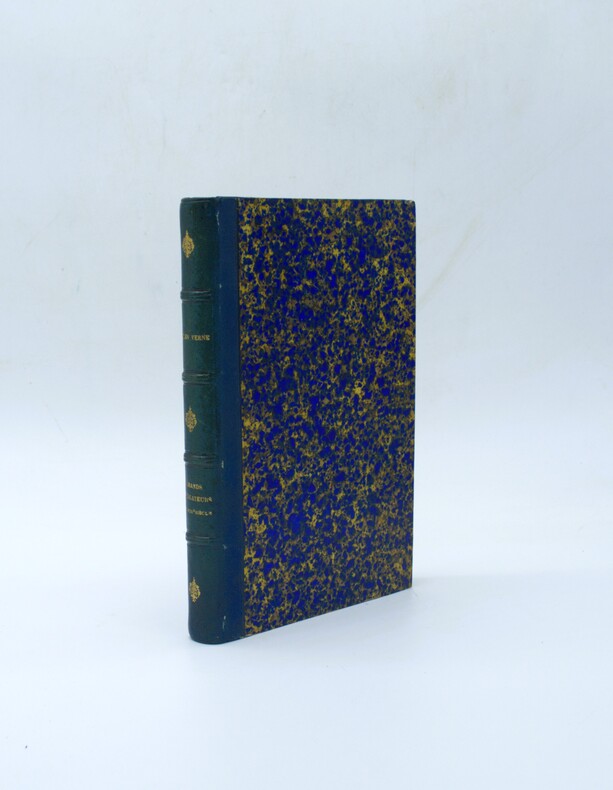
1879Best.-Nr. PHO-2277Paris, Hetzel et Cie, s.d. [1879]. In-4° de VI, [2], 464 pp. 51 dessins par P. Philippoteaux. 66 fac-similé‚ et cartes par Matthis et Morieu. Demi-chagrin bleu, dos à 4 faux-nerfs orné, titre doré, tranches mouchetées rouges. (Reliure de l'époque). Quelques rousseurs. Bel ex. Ouvrage historique et géographique, réalisé en collaboration
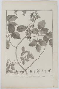
1798Best.-Nr. 175968London. 1798. Engraving on watermarked wove paper 33.3 x 24.9 cm plate mark 42 x 26.6 cm sheet edges a little browned and dusty but a very good dark impression. Fine botanical illustration of the climbing chili prepared for the 'Account of the Voyage of Jean-François Galaup-La Pérouse' 1785-1788 the great but ill-fated French voyage of discovery and exploration. Guillaume Prevost was botanical artist on the ship L'Astrolabe and from a noted family of botanical artists. . unknown
1968Best.-Nr. 55058Amsterdam And NY: N. Israel and Da Capo Press. Near Fine. 1968. Hardcover. Two volume set; lacks atlas volume. Faux vellum gilt. Facsimile edition. Corners lightly bumped. Contents fine. The clear plastic DJs have some chips/tears. ; quarto . N. Israel and Da Capo Press hardcover
1968Best.-Nr. 50398Amsterdam and New York: N. Israel and Da Capo Press 1968. Later printing. Hardcover. Very good condition. Quarto. 25391; 253117pp. Index. Plus facsimiles of the original 1799 title pages and 56 facsimile pages of the original prefaces and introductions. Publisher's mylar dust jackets. Faux vellum boards with gilt lettered blue labels on front covers and spines. "Bibliotheca Australiana #27 and #28." The text is complete in two volumes but this set lacks the atlas volume and is priced accordingly. Mylar with wear small chips and tears some tears larger. N. Israel and Da Capo Press hardcover
1968Best.-Nr. 50398Amsterdam and New York: N. Israel and Da Capo Press 1968. Later printing. Hardcover. Very good condition. Quarto. 25391; 253117pp. Index. Plus facsimiles of the original 1799 title pages and 56 facsimile pages of the original prefaces and introductions. Publisher's mylar dust jackets. Faux vellum boards with gilt lettered blue labels on front covers and spines. "Bibliotheca Australiana #27 and #28." The text is complete in two volumes but this set lacks the atlas volume and is priced accordingly. Mylar with wear small chips and tears some tears larger. N. Israel and Da Capo Press hardcover books
Best.-Nr. ORD-14195Préface du Contre-Amiral de Brossard. Paris. Gelly. Les Gentishommes de la Mer. (1970). 2 volumes in-8 (168 x 216mm) pleine peau maroquinée rouge, dos à 4 nerfs, titre et caissons or, frise et filets bordant les plats, gardes marbrées, tête dorée, étui bordé de maroquin rouge, 278 et 262 pages, nombreuses illustrations hors texte en noir ou en couleurs souvent à double page. Exemplaire sur vergé d'Arches. Très bon état.
1847Best.-Nr. 4061Paris, Belin-Leprieur et Morizot, (1847). 22 gravures sur bois, 23 planches, dont quelques unes en couleurs / 22 Holzschnitte, 23, teils farbige Tafeln, 474 S., 1 Bl., goldgeprägter, illustrierter Original-Leinenband mit Goldschnitt. Zustand 2, Namenseintrag in Tinte auf Spiegel.
1981Best.-Nr. 2987A PARIS. CHEZ JEAN DE BONNOT. 1981. 2 VOLUMES IN-8 (21 X 15 X 8 CENTIMETRES ENVIRON), RELIURE DE L’EDITEUR PLEINE BASANE CHAGRINEE BLEUE, DOS LISSE ORNE DE CAISSONS DORES AVEC FLEURONS ROYAUX ET MARITIMES, PLATS ESTAMPES D’UN DECOR CARTOGRAPHIQUE A FROID, TITRE ET TETE DORES. ILLUSTRE DE NOMBREUSES GRAVURES ET CARTES IN ET HORS TEXTE. COMPLETE PAR UN GLOSSAIRE. BEL «EXEMPLAIRE DE TETE DU TIRAGE SPECIAL».
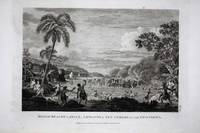
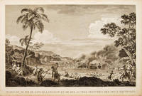
Best.-Nr. 8794London: 1798. No binding. Very Good. 225 x 310 mm. in good condition. This is a view of the massacre of twelve members of the expedition of the French Admiral and explorer le Comte de La Pérouse at Tatuila on the island of Maouna in Samoa. It was a great loss to the expedition Robert de Lamanon was a botanist and physician. La Perouse's second in command Paul Antoine Fleuriot also lost his life. Jean-Francois de Galoup Comte de La Perouse led a French scientific expedition to the Pacific in 1785-88. He was one of the most noted naval commanders and navigators in France and was selected by King Louis XVI to complete Captain James Cook's exploration of the western Pacific. In a rare moment of co-operation the British Admiralty furnished scientific equipment to measure variations in magnetic north and for determining longitude. Fortunately for us La Perouse was meticulous in sending copies of his detailed logs and surveying via other ships as well as overland. His last contact was in the spring of 1788 with a British ship in Botany Bay Australia. The expedition was never heard from again. When the French Government realised that it had been lost they decided to publish an account as in many other ways it is regarded as one the greatest French voyages of exploration. It was not until 1827 that their fate was known. Howes USIana L93; Nordenskiold Collection v. 2; Phillips 688; Sabin 38960; Shirley 'Atlases in the BL' G.LPR-1a. 1798 unknown
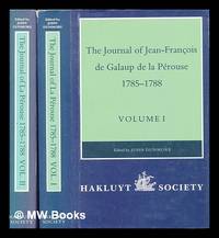
1994Best.-Nr. 448960London : The Hakluyt Society 1994. First Edition. Hardcover. Fine cloth copies in a fine very slightly edge-dulled dust wrappers. Well-preserved overall. Not price-clipped. Volumes one and two. Series: Works issued by the Hakluyt Society. 2nd series ; 179. Physical description: 2 volumes ccxl 613 pages : illustrations maps ; 23 cm. Notes: Translated from the French. Subjects; Boussole Ship. Astrolabe Ship. Voyages and travels History 18th century. Explorers France Biography. London : The Hakluyt Society hardcover
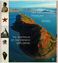
2014Best.-Nr. 106444n.p.: Somogy Editions d'Art. 2014. 1st ed. square quarto text in French and English pp.192 profusely illus with colour and b&w plates maps photographs original boards in dust-jacket. Near fine condition. Explorations to the Australian coast of French explorers during the 18th and 19th centuries documented here through contemporary photographs expedition drawings and historical commentary. Explorers include Saint-Alouarn La Perouse Bruny d'Entrecasteaux Labillardiere Baudin Henri Freycinet Louis Freycinet Rose Freycinet Hamelin Peron and others. Includes artworks by artists Lesueur and Petit. 1st edition. Boards in d.j. Somogy Editions d'Art hardcover
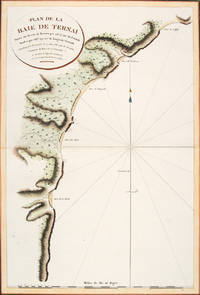
1797Best.-Nr. 56364Atlas Du Voyage De La Pérouse. Paris: L'Imprimerie de la Republique. 1797. A crisp clear map of the Bay of Ternai in Tartary. Relief shown by hachures; depths by soundings. From the Voyages of La Pérouse who set sail from France in 1785 to continue the discoveries of Captain Cook. He was shipwrecked in 1788 but his narrative maps and views survived and were published in 1797. Thirty-eight years later the scattered remains of La Boussole and L'Astrolabe was discovered wrecked on a vicious reef on an atoll in the New Hebrides. Copper engraving. Fine condition; slight browning and foxing to wide margins not affecting the image. Hand coloured. Size: 42.5 x 56.5 cm. 16½ x 22 inches unknown
Best.-Nr. VOY918M1822-1824, Étienne Ledoux, Paris. Complet. 14 volumes in-8, demi-basane havane de l' époque, dos lisse orné, titre et tomaison dorés. Fronttispices illustrés. [2]-XII-469-[2], [6]-473-[2], [6]-498-[2], [6]-445-[2], [6]-474-[2], [6]-496-[2], [6]-478-[2], [6]-473-[2], [6]-489-[2], [6]-475-[2], [6]-479-[2], [6]-481-[2], [6]-474-[2], [6]-426-[2]. Volumes non coupés. Frottements diffus des dos, coins et coiffes. Pièces de titre et tomais parfois effacées. Intérieur globalement agréable. Usure normale du papier. Ensemble satisfaisant
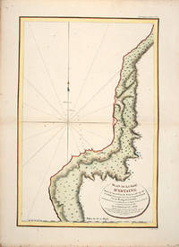
1797Best.-Nr. 55865Atlas Du Voyage De La Pérouse. 1797. From the Voyages of La Pérouse who set sail from France in 1785 to continue the discoveries of Captain Cook. He was shipwrecked in 1788 but his narrative maps and views survived and were published in 1797. Uglegorsk Region Russia Full Title: Plan de la Baie d'Estaing. Situee a la cote de l'ouest de Tchoka par 48059'38" de latitude nord et par 14000'42" de longitude orientale prise du mouillage de l'Astrolabe. Cette Baie fut decouverte le 20 juillet 1787 par les Fregates Francaises la Boussole et l'Astrolabe commandees par MM. de La Perouse et de Langle. L. Aubert scripsit. Atlas du Voyage de la Perouse no. 51. Paris: L'Imprimerie de la Republique An V 1797. Engraved by AUBERTL. Size: 255 x 400 mm. Copper engraving. Uncoloured. Very good condition. unknown
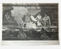
1798Best.-Nr. 003682G. G & J. Robinson. LA PEROUSE Jean Francois; DUCHÉ DE VANCY Jean Baptiste; HEATH James. Dress of the Inhabitants of Baie de Castries. An engraving from the atlas volume of plates of the voyage of Jean-François de Galaup comte de La Pérouse published in London by G. G. & J. Robinson Paternoster Row 1798. Copper-engraving plate no. 54 after a drawing by the Duché de Vancy engraved by Heath with the imprint "Published as the Act directs Nov. 1st 1798". 330x220mm light uniform toning mild marginal soiling a little show-through from the verso but a clean well-defined impression with good margins. Overall very good. Image depicting domestic life costume and material culture of the Indigenous inhabitants of Baie de Castries on the north-west coast of America then described as the eastern coast of "Tartary" in contemporary French and British geographical usage. This plate forms part of the celebrated series of engravings prepared for the posthumous publication of La Pérouse's voyage 1785-1788 documenting the French expedition's survey of the North Pacific including Alaska the Sea of Japan Kamchatka and the northwest coast of America. The draughtsman Jean-Baptiste Claude Duché de Vancy served as official artist to the expedition while Heath was one of the principal London engravers engaged for the English edition of the atlas. The scene records the built environment clothing and domestic practices observed at Baie de Castries during La Pérouse's brief but historically important visit in 1786 shortly before the expedition's disappearance in the South Pacific. . Very Good. Soft cover. 1st Edition. 1st Printing. 1798. G. G & J. Robinson paperback
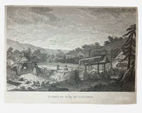
1798Best.-Nr. 003681G. G & J. Robinson. LA PAROUSE John Francis Galaup; DUCHÉ DE VANCY Jean Baptiste; HEATH James: Tombs of Baie de Castries. An engraving from Charts and Plates to La Pérouse's Voyage London: G. G. & J. Robinson 1798. Copper engraving 310 × 230 mm plate on laid paper with good margins; plate mark visible; light overall toning and a few faint spots with a shallow horizontal fold as issued otherwise in very good condition. A view of the tombs at Baie de Castries showing a small settlement with two figures in the foreground and the distinctive raised wooden burial structures. Bais de Castries described in contemporary sources as lying on the eastern coast of Tartary corresponds to the North Pacific explored by La Perouse in 1787 in the region now identified with the northwest coast of America southeast Alaska. The drawing was made by Jean-Baptiste Louis Claude Théodore duc de Vancy one of the official artists attached to the expedition of Jean-François de Galaup comte de La Pérouse whose role was to record landscapes sites and customs encountered during the voyage. La Perouse and his crew wouldn't make it back to Paris with it latterly being discovered that his ship was wrecked at Vanikoro now the Solomon Islands. The plate was engraved in London by James Heath among the leading line engravers of the late eighteenth century and published by G. G. & J. Robinson for the atlas volume Charts and Plates to La Pérouse's Voyage Round the World issued in 1798 as part of the English edition of the expedition's results. . Very Good. Soft cover. 1st Edition. 1st Printing. 1798. G. G & J. Robinson paperback
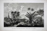
Best.-Nr. 8786Paris: 1797. No binding. Very Good. 270 x 410 mm. in good condition. This is a view of the town of Buru in Indonesia recording the visit of the French Admiral and explorer le Comte de La Pérouse. Jean-Francois de Galoup Comte de La Perouse led a French scientific expedition to the Pacific in 1785-88. He was one of the most noted naval commanders and navigators in France and was selected by King Louis XVI to complete Captain James Cook's exploration of the western Pacific. In a rare moment of co-operation the British Admiralty furnished scientific equipment to measure variations in magnetic north and for determining longitude. Fortunately for us La Perouse was meticulous in sending copies of his detailed logs and surveying via other ships as well as overland. His last contact was in the spring of 1788 with a British ship in Botany Bay Australia. The expedition was never heard from again. When the French Government realised that it had been lost they decided to publish an account as in many other ways it is regarded as one the greatest French voyages of exploration. It was not until 1827 that their fate was known. Howes USIana L93; Nordenskiold Collection v. 2; Phillips 688; Sabin 38960; Shirley 'Atlases in the BL' G.LPR-1a. 1797 unknown
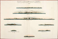
1797Best.-Nr. 56369Paris: 1797. Eight profiles showing Mt. la Touche Baie de la Touche present Englefield Bay C. Hector present Cape St. James I. Kerouard Iles Sartine Scott Islands and Cap Blanc. The map is from the Voyages of La Pérouse who set sail from France in 1785 to continue the discoveries of Captain Cook. He was shipwrecked in 1788 but his narrative maps and views survived and were published in 1797. Thirty-eight years later the scattered remains of La Boussole and L'Astrolabe was discovered wrecked on a vicious reef on an atoll in the New Hebrides. Atlas Du Voyage De La Pérouse. Paris: Copper engraving. Very good condition; slight browning along the centrefold and foxing to wide margins a tear to the bottom margin along the centrefold not affecting the image. Hand coloured. Size: 58.5 x 43 cm. unknown
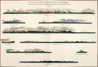
1797Best.-Nr. 56368Paris: 1797. Nine profiles showing Mt. Beautems Mt. Crillon Mt.St. Hyacinthe Port Guibert Iles des Espagnols Iles Necker Necker Islands Ile Sn. Carlos Pointe des Brisants present Estevan Point and Baie Clonard Beresford Bay. The map is from the Voyages of La Pérouse who set sail from France in 1785 to continue the discoveries of Captain Cook. He was shipwrecked in 1788 but his narrative maps and views survived and were published in 1797. Thirty-eight years later the scattered remains of La Boussole and L'Astrolabe was discovered wrecked on a vicious reef on an atoll in the New Hebrides. Atlas Du Voyage De La Pérouse. Paris: Copper engraving. Very good condition; slight browning along the centrefold and foxing to wide margins a tear to the bottom margin along the centrefold not affecting the image. Hand coloured. Size: 58.5 x 43 cm. unknown
1987Best.-Nr. BN257250Stuttgart ; Wien : Ed. Erdmann 1987. 1987. Zu den Klippen von Vanikoro : Weltreise im Auftr. Ludwigs XVI. 1785 - 1788. Jean-François de Lapérouse. Nach Lapérouses Tagebüchern aufgezeichn. von M. L.-A. Milet-Mureau. Übers. bearb. u. hrsg. von Klaus Fischer Alte abenteuerliche Reiseberichte Zu den Klippen von Vanikoro : Weltreise im Auftr. Ludwigs XVI. 1785 - 1788. Jean-François de Lapérouse. Nach Lapérouses Tagebüchern aufgezeichn. von M. L.-A. Milet-Mureau. Übers. bearb. u. hrsg. von Klaus Fischer Alte abenteuerliche Reiseberichte La Pérouse Jean-François de Galaup und Klaus Fischer Stuttgart ; Wien : Ed. Erdmann unknown
1971Best.-Nr. 15648Gelly 1971 Un ensemble de sept volumes in-8 reliure d'éditeur sous emboitage en plein chagrin maroquiné rouge, sur vergé, exemplaires réservés aux artisans de l'édition (H.C.), parfait état.
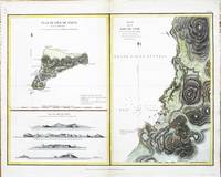
Best.-Nr. 8108London: G. G. & J. Robinson. 1799. No binding. Good. 380 x 500 mm. recent wash colour in good condition. This map features Easter Island in the Pacific Ocean. From the English edition of the 'Atlas du Voyage de La Perouse' published by G. G. & J. Robinson. The island is best known for the famous stone heads. This map records the visit of the French Admiral and explorer La Pérouse. Jean-Francois de Galoup Comte de La Pérouse 1741-88 led a French scientific expedition to the Pacific in 1785-88. He was one of the most noted naval commanders and navigators in France and was selected by King Louis XVI to complete Captain James Cook's exploration of the western Pacific. In a rare moment of co-operation the British Admiralty furnished scientific equipment to measure variations in magnetic north and for determining longitude. Fortunately for us La Perouse was meticulous in sending copies of his detailed logs and surveying via other ships as well as overland. His last contact was in the spring of 1788 with a British ship in Botany Bay Australia. The expedition was never heard from again. When the French Government realised that it had been lost they decided to publish an account as in many other ways it is regarded as one the greatest French voyages of exploration. It was not until 1827 that their fate was known. They had been shipwrecked on the island of Vanikoro and many of the survivors were killed. Hill p. 174; Howes 1962 L93; Howgego 2003 L20; Suarez 2004 p. 169 fig. 164. G. G. & J. Robinson. 1799 unknown
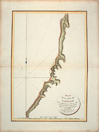
1797Best.-Nr. 55866Paris: L'Imprimerie de la Republique.Atlas Du Voyage De La Pérouse. 1797. From the Voyages of La Pérouse who set sail from France in 1785 to continue the discoveries of Captain Cook. He was shipwrecked in 1788 but his narrative maps and views survived and were published in 1797. Tomari Region Russia ; Sakhalin Russia Full Title: Plan de la Baie de Langle. Situee a la partie ouest de l'Ile de Tchoka par 47048'36" de latitude nord et 139057'54" de longitude orientale. L. Aubert scripsit. Atlas du Voyage de la Perouse no. 49. Paris: L'Imprimerie de la Republique An V 1797. Engraved by AUBERTL. Size: 255 x 400 mm. Copper engraving. Hand coloured. Very good condition. unknown
1797Best.-Nr. 55648Atlas Du Voyage De La Pérouse. 1797. Scene showing the locals attacking voyagers as they disembark from their boats. From the Voyages of La Pérouse who set sail from France in 1785 to continue the discoveries of Captain Cook. He was shipwrecked in 1788 but his narrative maps and views survived and were published in 1797. Copper engraving. Very good condition. slight browing around edges but not effecting image Uncoloured. Size: 40 x 25.5 cm. 15½ x 10 inches unknown
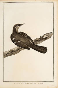
1797Best.-Nr. 55672Paris. 1797. Print of an Alaskan Merle Bird. From the Voyages of La Pérouse who set sail from France in 1785 to continue the discoveries of Captain Cook. He was shipwrecked in 1788 but his narrative maps and views survived and were published in 1797. Atlas Du Voyage De La Pérouse. Size: 255 x 400 mm. Copper engraving. Uncoloured. Very good condition. Slight browing around edges but not effecting image. unknown