La Perouse, J F G, Comte de:Biblio.com
178 Ergebnisse
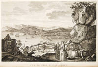
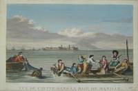
1797Best.-Nr. 3921Paris c. 1797. Copper engraving by Simonet after Duche de Vancy and J.M. Moreau le Jeune approx 29 x 42 cms trimmed to platemark left-hand margin extended hand-coloured blank verso. Map unknown
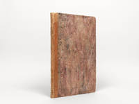
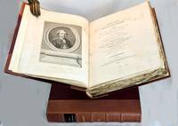
1798Best.-Nr. 000252Atlas to the English edition of the report of the famous voyage around the world by La Pérouse who - in addition to Bougainville and Cook - contributed decisively to the exploration of the Pacific region. Without the two text volumes. Description: Contemporary quarter calf with marbled paper boards. Flat spine lettered and decorated in gilt. Quarto: 44 × 28.5 cm; unpag. 1 engr. frontispiece 1 engr. title page and 67 full-page copper-engraved plates thereof are: 37 plates and 30 maps 20 fold-outs. Ref.: Boucher i p. 149-54; Cox i 67; Sabin 3896 Condition: Binding a bit scuffed and with a few surface abrasions at edges. Light waterstains to the gutter of first few leaves. Contents occasionally somewhat soiled more noticeable in the first few leaves slight tanning at edges. Three small brown spots on plate 29 visible between plates 27-37. Lacking plates 1 map of the world and 36 male and female Partridge of California. Some offsetting from plates. Despite the occasional minor blemish a good copy. Notes: La Pérouse 1741-1788 a French naval officer and explorer was appointed in 1785 to lead a scientific expedition to explore the Pacific. The expedition stopped in Chile Hawaii Alaska California Mauritius Réunion Macau Japan Russia and Australia. However his journey ended tragically. In January 1788 he reached Botany Bay. He sent his final notes to France from there before sailing on towards Tonga in March. When no further reports arrived in France for a long period of time the first search expedition was launched in 1791. However it remained unsuccessful. It was not until 1826 that Peter Dillon an Irish sea captain proved that the island of Vanikoro was the site of the accident where the expedition's ships met a tragic end on the reef. The first English edition was published in two volumes in octavo format by John Stockdale in London in 1798. Two other translations were published by two different publishers in 1798 and 1799: J. Johnson's first edition appeared in 1798 and J. Robinson's in 1799. Regarding these editions Edward Cox writes in his Reference Guide to the Literature of Travel: "On the unexpected publication of this famous voyage at Paris in the previous year 1797 there was considerable competition among English publishers to bring out the English translation. Three different translations were made and published during 1798-99 and different engravers were employed for making the plates. Stockdale's appeared first in June 1798. Robinson's edition of 1799 is the most esteemed edition in English later editions being usually based on it." G. G. & J. Robinson hardcover
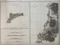
1797Best.-Nr. 299774Paris: L'Imprimerie de la Republique 1797. Map. Engraving with hand coloring. Sheet measures 21 1/4" x 28" This chart depicts Easter Island with a close-up of Cook's Bay. Relief is depicted by hachure and elevation is shown from several vantage points. Points and peaks of the elevation views correspond to labels on the map. The Bay shows depths and various structures are labeled. The map appeared as Plate 10 in "Atlas du Voyage de La Perouse." It is in very good condition. Stain to upper margin minor foxing marks. Jean Francois de Galaup 1741-c.1788 was a French Navy officer and explorer known for his travels in Oceania. In 1787 he explored the northeast and mainland Asian coasts in the area of Korea. Other voyages included Alaska Japan Australia and the South Pacific. This map demonstrates some of the many observations and findings made on his journeys. L'Imprimerie de la Republique unknown
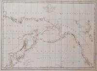
1797Best.-Nr. 016791Paris: La Perouse 1797. Map. Very good condition. Unbound. First Edition. Folio. A large map in black and white. The map is included in the Atlas volume of La Perouse's Voyages. The west coast of North America is shown as south as Baja California and north to above 70 degrees latitude. Shows part of China and all of Japan and Kamtschatka and an attractive depiction of the Behring Straits and the Alaskan Archipelago. There are about a dozen small dark spots and dozens of others that are tiny but the map remains quite clean retaining large margins. La Perouse Paperback
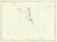
1797Best.-Nr. 016788Paris: La Perouse 1797. Map. Very good condition. Unbound. First Edition. Folio. A large map beautifully decorated with original outline color. The map is included in the Atlas volume of La Perouse's Voyages but was drawn from Spanish manuscripts as it was thought that it might be a part of the Northwest Passage. The map has an extra vertical crease from mis-folding but is quite clean and has large margins which are lightly soiled here and there. La Perouse Paperback
1786Best.-Nr. 24580Paris 1786. Other. In excellent condition. 490 by 860mm 19¼ by 33¾ inches. Copper engraving uncolored as published. unknown
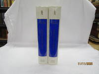
1968Best.-Nr. 55058Amsterdam And NY: N. Israel and Da Capo Press. Near Fine. 1968. Hardcover. Two volume set; lacks atlas volume. Faux vellum gilt. Facsimile edition. Corners lightly bumped. Contents fine. The clear plastic DJs have some chips/tears. ; quarto . N. Israel and Da Capo Press hardcover
1799Best.-Nr. 101564London: A. Hamilton for G. G. and J. Robinson J. Edwards and T. Payne. 1799. First thus two text volumes quarto later half-leather binding with gilt title labels and raised bands spines cloth sides Vol. I: pp. x lvi 539; Vol. II: pp. viii 531 plus index and errata page pp xiii. Engraved frontis portrait plate of La Perouse by Heath in first volume light water stain to upper plate and title page all edges untrimmed some unopened at top edge very light scattered foxing mostly to title pages minor scuffs to leather spine. The two text volumes without the Atlas volume complete and unabridged. Very good condition. The first quarto unabridged and "best edition" in English. A translation of La Perouse's scientific voyage around the world which departed France in 1785 and visited Chile and Hawaii Alaska California Japan Russia the South Pacific and Australia visiting Botany Bay in 1788 before sailing on and eventually discovered to have been wrecked in the Solomon Islands. A landmark work of exploration. 1st thus. Half leather. A. Hamilton for G. G. and J. Robinson, J. Edwards and T. Payne, hardcover
Best.-Nr. 1385831642.Ghardcover. Good. Access codes and supplements are not guaranteed with used items. May be an ex-library book. hardcover
1968Best.-Nr. 50398Amsterdam and New York: N. Israel and Da Capo Press 1968. Later printing. Hardcover. Very good condition. Quarto. 25391; 253117pp. Index. Plus facsimiles of the original 1799 title pages and 56 facsimile pages of the original prefaces and introductions. Publisher's mylar dust jackets. Faux vellum boards with gilt lettered blue labels on front covers and spines. "Bibliotheca Australiana #27 and #28." The text is complete in two volumes but this set lacks the atlas volume and is priced accordingly. Mylar with wear small chips and tears some tears larger. N. Israel and Da Capo Press hardcover
1968Best.-Nr. 208132Amsterdam. Nico Israel. 1968. 4to. 539547pp. Publisher's mylar djs on text volumes. Sl.discolouration to the spine of the atlas volume. Scarce. Bibliotheca Australiana nos. 27 28 & 29 Facsimile re-issue of the London edition of 1799. An interesting French perspective on the arrival of the First Fleet in 1788. Amsterdam. Nico Israel. unknown
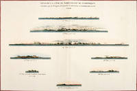
1797Best.-Nr. 56369Paris: 1797. Eight profiles showing Mt. la Touche Baie de la Touche present Englefield Bay C. Hector present Cape St. James I. Kerouard Iles Sartine Scott Islands and Cap Blanc. The map is from the Voyages of La Pérouse who set sail from France in 1785 to continue the discoveries of Captain Cook. He was shipwrecked in 1788 but his narrative maps and views survived and were published in 1797. Thirty-eight years later the scattered remains of La Boussole and L'Astrolabe was discovered wrecked on a vicious reef on an atoll in the New Hebrides. Atlas Du Voyage De La Pérouse. Paris: Copper engraving. Very good condition; slight browning along the centrefold and foxing to wide margins a tear to the bottom margin along the centrefold not affecting the image. Hand coloured. Size: 58.5 x 43 cm. unknown
1797Best.-Nr. 55649Paris. 1797. View of Brazil from the Voyages of La Perouse who set sail from France in 1785 to continue the discoveries of Captain Cook. He was shipwrecked in 1788 but his narrative maps and views survived and were published in 1797. Atlas Du Voyage De La Pérouse. Copper engraving. Very good condition. slight browing around edges but not effecting image. Uncoloured. Size: 40 x 25.5 cm. unknown
Best.-Nr. 0274860783.Ghardcover. Good. Access codes and supplements are not guaranteed with used items. May be an ex-library book. hardcover
Best.-Nr. 0274860805.Ghardcover. Good. Access codes and supplements are not guaranteed with used items. May be an ex-library book. hardcover
Best.-Nr. 0274860791.Gpaperback. Good. Access codes and supplements are not guaranteed with used items. May be an ex-library book. paperback
1799Best.-Nr. 38451London: G.G. & J. Robinson 1799. Original copper engraving. This detailed map shows the south eastern part of Alaska. A fine copy of this engraving from Robinson's edition "usually considered to be the best one in English . and is extremely rare" Hill picturing and charting La Perouse's ill-fated voyage round the world. "La Pérouse's expedition was one of the most important scientific explorations ever undertaken to the Pacific and the west coast of North America . The charge to the expedition which took place between 1785 and 1788 was to examine such parts of the region as had not been explored by Captain Cook; to seek for an interoceanic passage; to make scientific observations on the various countries peoples and products; to obtain reliable information about the fur trade and the extent of Spanish settlements in California; and to promote the inducements for French enterprise in that quarter . La Pérouse and his men did important geographical research . The voyage also included the first foreign scientific group ever to visit California. La Pérouse sent dispatches back to France from Kamchatka and Botany Bay. The two ships then set sail from Botany Bay in 1788 and were never heard from again" Hill. It was not until the 1820s that the wrecks of his ships were discovered on a reef in the Santa Cruz group. When it became clear that something had happened to the expedition a decision was made to publish the journals he had transmitted home. Cowan p.383; Ferguson 288; Hill 2004 975; Howes L93 'b'; Lada-Mocarski 52; Sabin 38962; TPL 596; Wagner Cartography of the Northwest Coast 837-848 pp.199-201; Zamorano 49. G.G. & J. Robinson unknown
Best.-Nr. 2012632394.Gpaperback. Good. Access codes and supplements are not guaranteed with used items. May be an ex-library book. paperback
Best.-Nr. 2012632386.Gpaperback. Good. Access codes and supplements are not guaranteed with used items. May be an ex-library book. paperback
Best.-Nr. 2019162024.Gpaperback. Good. Access codes and supplements are not guaranteed with used items. May be an ex-library book. paperback
Best.-Nr. 2012632408.Gpaperback. Good. Access codes and supplements are not guaranteed with used items. May be an ex-library book. paperback
Best.-Nr. 2019162040.Gpaperback. Good. Access codes and supplements are not guaranteed with used items. May be an ex-library book. paperback
Best.-Nr. 0274860775.Gpaperback. Good. Access codes and supplements are not guaranteed with used items. May be an ex-library book. paperback
1800Best.-Nr. 21185London 1800. Very good overall. Copper engraving of two Tlingit women of the Pacific Northwest. Port des Francais is now known as Lituya Bay in southeast Alaska. The engraving depicts the women at the sea coast seated under trees wearing fur cloaks one viewed in profile each with lip plates or labrets. Engraved by Deeves after a drawing by Prior. From Voyage de La Perouse Autour du Monde. 4to 8x 10" paper; 6 1/4 x 8 1/2" image. unknown
1798Best.-Nr. 496London: G & T Robinson 1798. The English edition of a map published to accompany La Perouse' Voyage. G&T Robinson Nov. 1st 1798. Covers from the Gulf of Carpentaria to the Solitaire Islands to the Navigator Islands in the east and to above New Guinea. Charts Maurelle's tracks. G & T Robinson unknown